
Stand on the waterfront at Mochlos, and the island opposite seems to explain itself. It looks like a small rocky islet that happens to lie close to the Cretan shore, sheltering the village from the worst of the sea. A few boats cross the narrow channel, people swim in the clear water, and the remains of an ancient settlement can be seen climbing the southern slope.
Yet the scene is misleading. The island we see today was not an island when the first great settlement grew there. It was the end of a peninsula, joined to Crete by a narrow neck of land that has since disappeared beneath the sea.
That lost connection changes the entire story.
Mochlos was not a community stranded on a barren rock. Its people did not have to carry every jar of water, every basket of grain and every animal across a strip of open water. They could walk between the settlement, the harbour and the fertile coastal plain. The rocky headland protected them from the north, while the narrow isthmus helped to create sheltered water on either side.
In other words, the vanished strip of land was not a minor detail. It was the reason Mochlos worked.
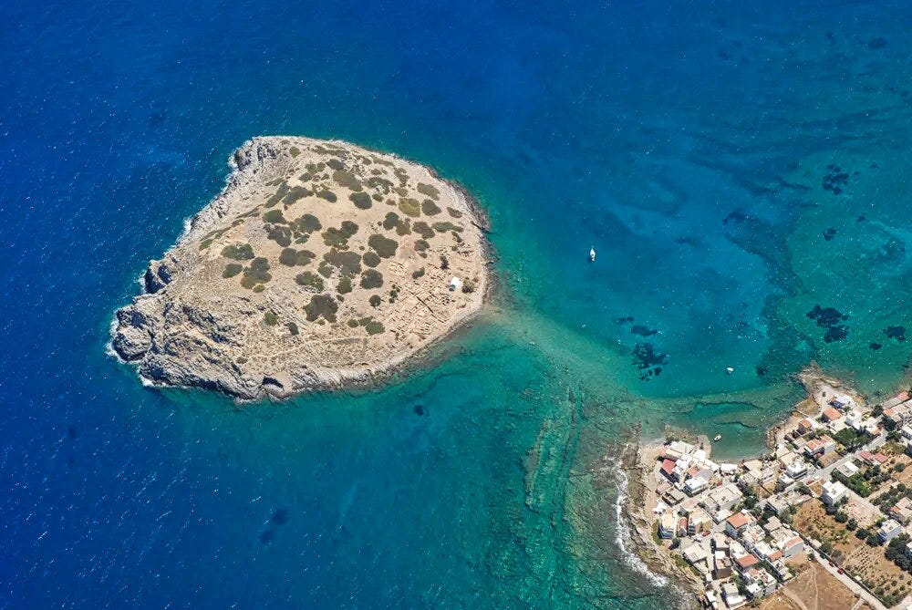
The newer work on the ancient shoreline has strengthened something I have felt for a long time. The island, the mainland workshops, the harbour and the coastal plain belong together. Mochlos Island was not an isolated place looking helplessly towards Crete. It was attached to Crete, physically and economically, and it formed part of a much larger working network across eastern Crete.
Once we put the land back where it was, Mochlos begins to make sense.
The channel between the modern village and the island is only about 150 metres across. On a calm day, particularly when the sun is high, darker shapes and changes in the colour of the water can be seen below the surface. They are traces of the submerged ridge that once joined the two sides.
The idea of a lost isthmus is not completely new. Underwater investigations in the 1950s identified ancient coastal remains and Roman fish tanks that were now below their original working level. Archaeologists realised that the relationship between land and sea had changed substantially since antiquity. Later surveys, bathymetric measurements and the study of submerged walls, beachrock and ancient shorelines made the picture much clearer.
The newest reconstruction brings several kinds of evidence together. The seabed preserves the shape of the former connection. Ancient walls continue towards water that would once have been dry land. Streets in the settlement face towards the former isthmus, as if directing movement towards it. The position of buildings on the mainland also shows that the ancient community occupied both sides of what is now a channel.
There is geological evidence as well. The Mochlos plain lies within a tectonic depression, a long block of land affected by faults on either side. Eastern Crete has not remained still while the sea has risen around it. The land itself has moved, sometimes gradually and sometimes during earthquakes.
This is why it is safer to speak of relative sea level. The water has risen in relation to the land, but that does not mean the change came from one steady rise of the Mediterranean. Global sea-level change played a part, especially after the last Ice Age, but local subsidence and sudden tectonic movements were also important.
Reconstructions suggest that during parts of the Bronze Age the sea around central and eastern Crete stood several metres lower in relation to the land than it does now. Around the beginning of the second millennium BC, the difference may have approached four metres in some calculations. By the height of the later Minoan town it was closer to three metres, although precise figures vary according to the evidence used and the date being reconstructed.
Later levels appear at roughly one and a quarter metres below the present sea, followed by another level a little more than half a metre below it. This does not describe a smooth line. It suggests a landscape altered in stages, with long periods of stability interrupted by movements of land and water.
The great earthquake of AD 365 is often connected with the final separation of Mochlos from the mainland. It certainly transformed the coasts of Crete, raising parts of the west dramatically while changing the relationship between land and sea elsewhere. Yet we should be cautious about making it the single moment when the isthmus vanished. Some evidence suggests that later subsidence, including movements in the seventeenth century and more recent centuries, completed a process that had already begun.
The exact date when a person could no longer cross with dry feet may never be known. The important fact is that, throughout the great Bronze Age life of Mochlos, the connection was there.
The word peninsula does not quite capture how useful the place was. Mochlos was a natural harbour system.
The rocky headland faced the open sea like a shield. Its northern side is steep, rough and exposed. Waves driven across the Cretan Sea strike the rocks with considerable force, and a boat approaching carelessly from that direction can still find itself in trouble. On the southern side, however, the headland slopes towards quieter water.
The isthmus acted as a low natural breakwater. It prevented the sea from driving straight through the gap, while the rocky mass of Mochlos protected the anchorage from the north. Depending on the wind, boats could find shelter on one side or the other. They could be hauled onto a beach, unloaded in shallow water or held safely while the weather passed.
This did not require a monumental harbour with stone quays and grand warehouses. Bronze Age boats were comparatively light and could be pulled ashore. What their crews needed was a dependable landing place, protection from dangerous winds, access to fresh water and food, and a community able to exchange, repair, store and redistribute goods.
Mochlos offered all of that.
The headland also provided a lookout. Anyone on the higher ground could watch vessels approaching from the north and west. The settlement on the southern slope remained less visible to ships passing offshore, giving it some protection from raiders. At the same time, the inhabitants were close enough to the open sea to launch quickly when conditions were right.
Behind the peninsula lay the Mochlos plain. This was not empty scrubland but the agricultural body that sustained the port. Seasonal streams carried soil and water down from the Ornos mountains, forming cultivable strips and small deltas. Grain, pulses, olives, grapes, figs and almonds could be grown there. Sheep and goats provided meat, hides, milk and wool.
The people of Mochlos therefore had the best of two worlds. They possessed a secure maritime doorway and a productive landscape immediately behind it. The isthmus joined those worlds so closely that they became one place.
The human story around Mochlos may go back far beyond the Bronze Age. Geological work on the alluvial fans east of the village has revealed stone objects that resemble tools of the Lower or Middle Palaeolithic.
At Mavroseli, about two kilometres east of Mochlos, a handaxe and another bifacial object were found deep within an exposed bank of ancient sediment. They were made from milky quartz and lay about nine metres below the modern surface. Their sharp, angular condition suggested that they had not been rolled a great distance by water.
At Loutres, closer to Mochlos, quartz flakes, a small biface, a cleaver and a possible Levallois core were found within or near ancient soils. One of those old soil horizons resembles deposits elsewhere in Crete that have been placed around 114,000 years ago, although the Mochlos sequence itself has not been securely dated.
These finds must be treated carefully. They are isolated objects in complex geological deposits, not the remains of a camp with hearths, bones and a clear occupation floor. Even so, they raise a remarkable possibility.
Crete has been separated from the surrounding mainlands for millions of years. If archaic humans reached the Mochlos coast during the Palaeolithic, they almost certainly crossed open water to get there. That would make this quiet corner of eastern Crete part of a far older story of seafaring than anything represented by the later Minoan town.
The coastline then was very different. During the cold phases of the Ice Age, vast quantities of water were held in glaciers, and the sea lay far below its present level. The alluvial fans east of Mochlos extended towards a shoreline that is now several kilometres offshore.
Even then, however, Crete was not connected to Greece or Asia by a convenient land bridge. Reaching it required some form of water crossing. Long before Mochlos became a harbour town, people may already have been looking out from this coast and treating the sea as a road.
The clearer history begins around 3100 BC, when the first permanent settlers established themselves at Mochlos. Some appear to have come from the Cyclades, probably through connections with Melos.
Their most telling material was obsidian. This black volcanic glass could be fractured into blades with exceptionally sharp edges, but it did not occur naturally at Mochlos. Much of it came from Melos, which meant that the people working it were already tied into an organised maritime route.
They were not merely using imported blades. Evidence suggests that raw obsidian arrived at Mochlos and was worked there before being distributed to other parts of Crete. From the beginning, then, Mochlos was doing what it would continue to do for centuries. It received material from overseas, transformed it through skilled labour and sent the finished product onwards.
A later movement of people, perhaps from central Crete, enlarged the settlement. Houses appeared along the southern shore and on the western terraces. By about 2600 BC, Mochlos had become a substantial village.
Estimates suggest that the settlement may have covered around eight-tenths of a hectare. Its population may have been between 220 and 330 people, and perhaps close to 500 if the houses on the mainland side of the isthmus are included. That is not a city by modern standards, but it was a significant community for Early Bronze Age Crete.
The peninsula explains how such a population could live there. The rocky headland itself had little soil and no dependable spring. The plain had the water, crops and grazing. The harbour brought trade. The isthmus held the arrangement together.
Mochlos became one of the most accomplished craft centres in early Crete. Its people worked obsidian, gold, silver, stone and faience. They produced objects that were not simply useful but beautifully made.
Stone vase makers selected coloured and patterned stone and shaped it with astonishing patience. Gold workers hammered thin sheets into diadems, ornaments and jewellery. Some pieces were decorated with simple raised designs, but simple does not mean crude. The work required a sure eye, steady hands and an intimate understanding of the material.
This is the part of the Minoan world that interests me most. The word Minoan is convenient, but it can tempt us into seeing everything through palaces, goddesses and the imagination of Arthur Evans. Mochlos gives us something more solid. It gives us workers, traders, sailors, farmers, potters, metalworkers and stone cutters.
It shows us how civilisation was maintained.
The cemetery on the western side of the headland reveals that success brought differences in wealth and status. More than twenty built tombs were found, together with burials in large jars, rock shelters and simple pits. Some tombs were modest, while two monumental groups stood apart on a terrace.
The largest contained a central chamber and adjoining spaces used as ossuaries. A body could be laid in the central room until the flesh had gone, after which the bones were moved to one side to make room for another burial. This allowed the tomb to serve a family or lineage over several generations.
Gold diadems, silver vessels and other symbols of rank suggest that certain families had acquired unusual authority. They may have controlled trade, organised religious ceremonies or negotiated between households. Yet the settlement does not look as though one ruler owned everything. It appears to have been a community of households that cooperated while maintaining their separate identities.
That balance matters. Mochlos was neither an equal little paradise nor a miniature palace state. It was a developing Cretan community in which wealth, religious standing and access to foreign goods were beginning to create a hierarchy.
Between about 1900 and 1670 BC, the political landscape of Crete changed. Large palace centres appeared, production became more standardised and regional economies became more closely organised.
Mochlos had no palace of its own. It seems to have entered the sphere of Malia, whose influence reached across the Gulf of Mirabello. Pottery at Mochlos began to follow forms and techniques found within that wider region. The potter’s wheel encouraged faster production, while drinking cups, tumblers and storage vessels became more regular in shape.
This did not mean that Mochlos lost its character. Local pottery production continued and expanded. The harbour still connected the community with islands and eastern Mediterranean routes, while the plain continued to feed it.
Recent excavation has given this period a new importance. A Middle Minoan building survived a major earthquake that destroyed much of the surrounding settlement. The house and nearby installations remained in use, with changes and repairs, for close to five centuries.
Beside it was a remarkable water-management system. Channels collected water from the bedrock slope and carried it into basins and reservoirs. When an earlier aqueduct was damaged, a new channel and cistern were created. Water was captured, diverted, stored and reused with the practical intelligence of people who knew that every reliable supply mattered.
Among these structures were large deposits of crushed Hexaplex trunculus shells, the shellfish once generally called murex. One deposit contained about 37.5 kilograms of washed shell fragments. Other concentrations were found near the house shrine and in the open area between the aqueducts.
These were not the remains of an unusually large seafood dinner. The shells had been deliberately broken to reach the gland that produced a powerful dye. The work involved unpleasant smells, careful control of liquids and considerable experience. Wool also had to be washed and stripped of grease before it could take the colour properly, which explains the value of the reservoirs and working tanks.
The evidence points towards a purple-dye industry, although parts of the actual workshop may still await discovery. The location is perfect. The sea provided the shellfish, the plain and surrounding hills provided wool, and the harbour connected the finished product with buyers elsewhere.
This also links Mochlos to the wider eastern Cretan network. Purple dye was produced or used at places such as Chryssi and Alatzomouri Pefka, while pottery, metal and other goods moved between Gournia, Pseira, Mochlos, Kavousi and settlements across the Gulf of Mirabello. These were not isolated dots on an archaeological map. They were parts of a working regional economy.
After about 1670 BC, Mochlos entered its most visible phase. The town was rebuilt and organised into blocks divided by paved or rock-cut streets. Houses rose in terraces up the southern slope, some with two or three storeys.
The streets are important because they show direction and purpose. They ran downhill towards the coast and the isthmus. People carrying jars, baskets, tools and imported material moved through a town physically aligned with its harbour.
On the mainland side stood the Artisans’ Quarter. Its buildings contained evidence for pottery making, textile production, metalworking, ivory carving and the manufacture of stone vessels. Farther east at Chalinomouri was a farmhouse that helped manage agricultural production on the plain.
This spread of activity across both sides of the isthmus is one of the strongest reasons for restoring the peninsula in our minds. The settlement was not confined to the rocky end. Workshops, houses, farms and harbour facilities formed a single landscape, connected by a strip of land people crossed every day.
One of the finest buildings was the House of the Metal Merchant. It had three levels, living rooms, staircases and basement storerooms packed with large storage jars. Two metal hoards were found inside.
One appears to have been a merchant’s stock. Another contained broken tools and pieces of copper kept for recycling. Bronze was too valuable to throw away. A broken axe, chisel or blade was not rubbish. It was material waiting to become something else.
Fragments of copper oxhide ingots point towards Cyprus, one of the great copper sources of the eastern Mediterranean. Tin was present too, although the ultimate source of ancient tin remains more difficult to establish. Together, these finds place Mochlos inside a chain of exchange reaching far beyond Crete.
The house also produced a bronze sistrum inspired by Egyptian instruments. It may have been made locally by someone who had seen such an object abroad, or who understood its form through travellers and imported ideas. Either way, it is a small sign of how open Mochlos was to the wider world.
Another remarkable find was a bronze trident. It was a working fishing implement, with barbs to hold the catch and fittings for a shaft and rope. It reminds us that the same people who dealt in imported copper still depended on the sea immediately outside their doors.
The largest building, known as B.2, was not a palace, but it borrowed features used in palatial architecture. It had a formal hall, a basin, columns, dining spaces, a kitchen and two pillar crypts reached by a staircase of fourteen surviving steps. It was probably a ceremonial and administrative centre where feasting, offerings and community gatherings took place.
Elsewhere, an open sacred enclosure held olive trees planted in large jars. Food and drink were prepared in nearby rooms, while cups and lamps suggest gatherings that continued after dark. A new study of plant remains from Mochlos is showing how closely ordinary subsistence and ritual were connected. Olives, grapes, grain and pulses were daily foods, but the same plants also carried meaning in ceremonies, offerings and communal meals.
This was not a town divided neatly into religion, business and domestic life. The activities overlapped. A merchant could take part in ritual. A workshop could stand beside a shrine. Wine could be both a drink and an offering. An olive tree could be agricultural, sacred and political at the same time.
Mochlos lay roughly 130 kilometres from Thera, and ash from the great volcanic eruption reached the town. A deep layer was found beneath the floor of a house built after the eruption.
That discovery helped to overturn the old story that Thera erupted and instantly destroyed Minoan civilisation. Mochlos recovered. People cleared, repaired and built new houses above the ash. The town continued to flourish for generations.
This does not mean the eruption had no effect. Earthquakes, ash fall, crop damage, disrupted shipping and fear may all have placed pressure on eastern Crete. Yet the people adapted. Mochlos records resilience, not immediate collapse.
The town suffered several earthquakes during the later Bronze Age. Walls were repaired, and streets resurfaced. Water systems were altered when channels broke. Houses were rebuilt, sometimes on the same foundations.
Then, around 1430 BC, the great working town was destroyed by fire. The cause remains debated. Earthquake, political conflict, attack and the expansion of Mycenaean power may all belong to the explanation. What we should avoid is replacing one simple catastrophe story with another.
The metal hoards give the destruction a human edge. Some may have been workshop stock or material stored for recycling, but others could have been hidden during danger. Their owners did not return for them.
After several thousand years, the tools were still waiting.
Mochlos was resettled around 1400 BC, but the new community was smaller and poorer. Thirteen houses have been identified, ranging from one-room structures to the much larger House Alpha.
The carefully paved streets of the earlier town were not restored. New buildings stood among the Minoan ruins, often using old walls without respecting the original plans. Workshops did not return on the former scale, although the harbour continued to support trade and fishing.
House Alpha belonged to someone of unusually high status, perhaps a telestas, a title associated with rank and landholding in the Mycenaean world. An older double-axe stand was reused there, suggesting that objects from the previous town still carried authority.
The cemetery at Limenaria lay on the mainland, south of the settlement. Thirty-one chamber tombs were excavated, almost all undisturbed. The dead were placed in decorated clay coffins or large jars, accompanied by pottery, jewellery, seals, weapons and ritual vessels.
Several tombs contained male and female couples. One burial might be moved when the second person was added, suggesting relationships that remained important after death. Painted coffins show octopuses, architectural patterns and mysterious figures, including one wearing what looks like an animal mask.
The isthmus still mattered. The harbour remained usable, and the mainland cemetery was easily reached. Mochlos had lost its old industrial power, but its geography continued to hold people there until the wider collapse of the Late Bronze Age world around 1250 BC.
For several centuries Mochlos fell quiet. Small-scale activity returned on the summit in the seventh century BC, and again in the fifth century. These occupations were limited, but the high ground remained valuable as a lookout and perhaps as a place connected with memory and ritual.
A much larger settlement appeared in the Hellenistic period. Houses and industrial buildings spread across the southern slope, although without the carefully ordered streets of the earlier town. A defensive circuit enclosed part of the settlement.
By then Mochlos was probably under the power of Hierapytna, ancient Ierapetra, which was expanding across eastern Crete. Hierapytna needed access to the north coast, and Mochlos provided a harbour where goods could be landed, taxed and transferred. Once again, its purpose came from its position.
Outside the wall stood a large industrial building containing a beam press. The press was used mainly for olive oil, though other agricultural processing may also have taken place. Amphorae and cooking vessels show busy practical activity, while animal bones, shells and plant remains reveal what people ate and produced.
Mochlos was no longer an independent centre. It was a useful harbour controlled by a stronger city. Customs dues collected there may have contributed to Hierapytna’s income, while oil and perhaps wine left in transport jars.
The complex was destroyed around 69 BC, close to the period of the Roman conquest of Crete. Overland routes across eastern Crete were also improving, and ports with easier inland access began to compete with Mochlos. Geography had made the settlement important, but new roads could change the value of that geography.
Roman activity continued in the area, although much of the evidence was removed by early excavators eager to reach the Bronze Age buildings below. Submerged walls and fish tanks show that the coast was still being used when the sea stood lower in relation to the land.
The fish tanks are valuable because they had to operate at a precise level. Water needed to enter and circulate without drowning the dividing walls. Their present position below the surface proves that the coast has subsided since they were built.
As the isthmus disappeared, the old harbour lost part of its protection. Water could pass across the former land bridge, bringing currents and waves into a space that had once been enclosed. The headland still offered shelter, but the harbour machine was damaged.
This helps explain why occupation on the island became less attractive. The disappearance of the connection did not make landing impossible, but it removed the easy route to water, fields and mainland roads. A place designed around walking and hauling goods across land had become dependent on boats.
Byzantine activity followed, including buildings near the shore and a fortified enclosure on the summit. The fortification had a long wall across the high ground, small towers and side walls descending towards the sea. Its date is not completely secure, but it may belong to the centuries of Arab raids and conflict before or during the Emirate of Crete.
From the summit, watchers could survey a long stretch of sea. Mochlos had returned to one of its oldest purposes, but now as a place of warning and defence rather than trade.
The remains continue into the Middle Byzantine period, perhaps as late as the twelfth century. By then the ancient town was a ruin beneath later walls. The peninsula had become an island, and its long life as an inhabited harbour settlement was ending.
During Venetian and Ottoman rule, the Mochlos plain continued to be cultivated, but permanent settlement moved towards the foothill villages of Lastros, Sfaka, Tourloti and Myrsini. From higher ground, people could watch the coast and remain less exposed to piracy and raids.
Farmers still descended to work the plain. They grew grain, olives, vines and pulses, maintained terraces and used seasonal watercourses. Small coastal boats continued to fish and carry produce, even when no formal town stood beside the ancient harbour.
By the nineteenth century Mochlos again served as a calling place for coastal vessels, including ships connected with Athens and Alexandria. It never became a great modern port, but its anchorage remained useful.
The present village was tiny at the beginning of the twentieth century. A census in 1900 recorded only eight inhabitants. Fishing, farming and small-scale trade gradually gave it a more permanent life, and tourism later added tavernas, rooms and seasonal employment.
During the Occupation, eastern Crete was first controlled by Italian forces. After Italy’s collapse in September 1943, German forces took over the region. The coast became a watched and dangerous boundary where boats, fishing and ordinary movement could attract suspicion.
Mochlos was not one of the main battlefields of the war, but that should not make us imagine that it stood outside events. Requisitions, shortages, military control and fear reached even the smallest coastal communities. Once again, the same sheltered water that offered opportunity in peace created anxiety during conflict.
Richard Seager began systematic excavation on the island in 1908. At times he employed more than a hundred workers, uncovering tombs, houses and a wealth of objects in a remarkably short season.
Seager understood the importance of the finds, but he concentrated on beautiful objects and pottery rather than carefully recording every building. Later Greek and American archaeologists had to return to the island, identify his trenches and reconstruct the architecture he had left poorly described.
Jeffrey Soles began a new study of the cemetery in the 1970s. In 1989, a long-running Greek-American excavation started under Soles and Costis Davaras, later joined and continued by a wider team of Greek and international specialists. Campaigns on the island and mainland have transformed our understanding of the settlement.
This work has done more than add spectacular finds. It has studied streets, workshops, storerooms, animal bones, charred seeds, residues in pots, metals, stone, shell, water channels and building materials. That is how a real town returns to life.
The excavation has also corrected the old habit of treating later remains as an inconvenience. Hellenistic, Roman and Byzantine Mochlos now receive the attention they deserve. Each period used the place differently, and each tells us something about changing power, technology and landscape.
Most importantly, the archaeological work has crossed the modern water. Excavation on the mainland, underwater observation and reconstruction of the ancient coast have reunited parts of Mochlos that the sea divided.
Mochlos is worth knowing because it teaches us to distrust the modern view. Landscapes change, and if we place an ancient settlement inside the wrong landscape, we can misunderstand almost everything about it.
Seen as an island, Mochlos appears difficult and inconvenient. Seen as a peninsula, it becomes an intelligent choice. It had a natural harbour, a protected settlement, a lookout, direct access to farmland and a narrow point through which goods and people could be managed.
It also shows that the civilisation of Bronze Age Crete did not live only in palaces. Palaces depended on places such as Mochlos. Copper did not walk from Cyprus to Knossos. Obsidian did not shape itself into blades. Purple cloth did not emerge from the sea ready to wear.
People sailed, unloaded, carried, hammered, crushed, washed, dyed, fired, stored and traded. Mochlos allows us to see those people.
The peninsula also makes the eastern Cretan network visible. Gournia, Pseira, Mochlos, Kavousi, Chryssi and the workshops of the Mirabello region were not separate worlds. Boats and paths joined them. Farmers supplied craftspeople, craftspeople supplied traders, and traders connected small Cretan communities with Cyprus, the Cyclades, Egypt and the eastern Mediterranean.
There is a modern lesson here, although it should not be forced. Mochlos shows how a relatively small change in sea level can redraw an entire human landscape. A rise measured in metres turned a peninsula into an island, altered a harbour and helped make an ancient settlement less practical.
The sea did not simply cover a strip of empty ground. It covered a road, a working shoreline and part of the town itself.
That is what I find most compelling about Mochlos. The water between the village and the island looks empty, but it is full of history. Beneath it lies the missing piece that joins the settlement to its farms, its workshops and its harbour.
When we put that piece back, the famous objects from Mochlos no longer look like treasure that somehow appeared on a lonely rock. They become the products of a capable, organised and thoroughly maritime Cretan community.
The island opposite the tavernas is still beautiful. Yet it is more interesting when we stop seeing it as an island and begin to see the drowned peninsula beneath it.
That narrow road under the water explains why people came, why they stayed, why they prospered and why, when the relationship between land and sea finally changed, ancient Mochlos gradually fell silent.
Comments
Nothing yet. Say the first thing.
Sign in to join the conversation.