
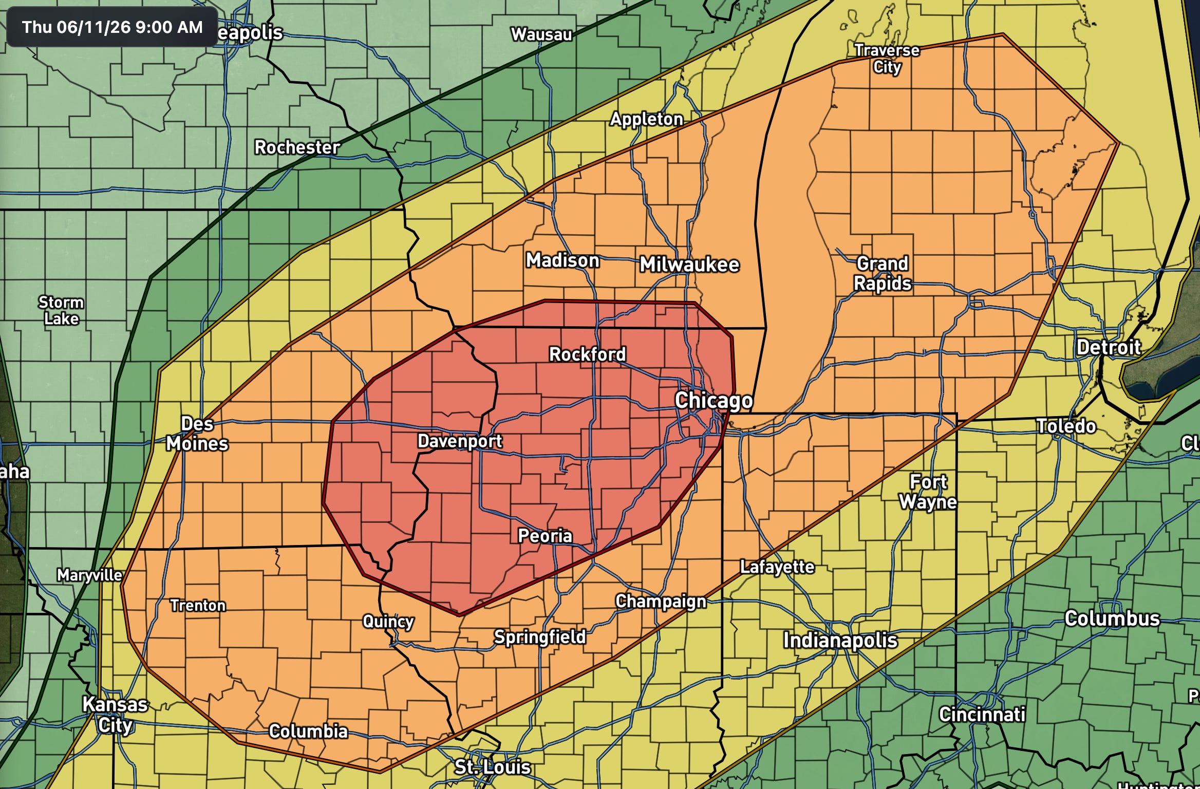
Moderate Risk Issued Today. SPC has upgraded part of the Midwest into the Great Lakes to a Moderate Risk, level 4 of 5. Damaging wind is the primary and most widespread threat, large hail comes with the stronger afternoon cells, and a corridor of strong tornado potential is on the table if storms stay discrete long enough. The risk area runs from Iowa and northeastern Missouri across northern and central Illinois, southern Wisconsin, northern Indiana, and central and southern Lower Michigan.
The setup. A potent mid-level trough is ejecting across the Upper Midwest into the Great Lakes, and it is dragging unusually strong mid-level winds along with it, on the order of 80 to 100 knots out of the southwest. That kind of flow in mid-June is the engine for today. At the surface, a low is deepening and lifting north out of the central Plains, with a trailing cold front to its south and a warm front (reinforced by leftover outflow from this morning’s storms) lifting north into the upper Midwest. The strengthening low-level jet keeps feeding moisture and warm air northward, which is what lets the atmosphere recover quickly behind the morning activity.
Timing and evolution. A severe MCS, meaning a large organized cluster of storms, is already ongoing this morning from southern Iowa into western Illinois. That is your first wind threat, with potential for significant gusts in the 70 to 75 mph range pushing east, possibly reaching Michigan by mid-afternoon. The afternoon is the more conditional part. As the warm front settles into northern Illinois and southern Wisconsin, new storms should fire along the front and near that boundary. Strongly sheared profiles favor supercells right out of the gate, capable of very large hail and tornadoes, a few of which could be strong to intense. The catch is mode and longevity: how long those cells stay discrete before they grow upscale into a bowing, wind-dominant line into the evening.
Where the uncertainty lives. The wind threat is high confidence. SPC carries a 45% wind probability with a significant (hatched) component, and that is well supported given both the morning MCS and a likely second round of bowing segments later. The tornado story is the wild card. It hinges on boundary placement and how cleanly the warm sector recovers behind the morning convection. If a sharp, well-positioned warm front sets up and supercells stay discrete through peak heating, a focused tornado corridor could come into better view in later outlook updates. The current 10% tornado and 15% hail numbers reflect that conditional ceiling, not a locked-in outcome.
What to watch. The single most important variable today is that warm front. Its exact latitude decides where the best low-level shear overlaps the strongest instability, and that overlap is where any strong tornado would come from. Keep an eye on where this morning’s storms leave their outflow, since that often anchors the afternoon boundary.
If you are in the footprint, treat the wind threat as the baseline and the tornado threat as the upside risk. Make sure warnings can reach you, and do not let the line’s arrival after dark catch you off guard.
No posts
Comments
Nothing yet. Say the first thing.
Sign in to join the conversation.