
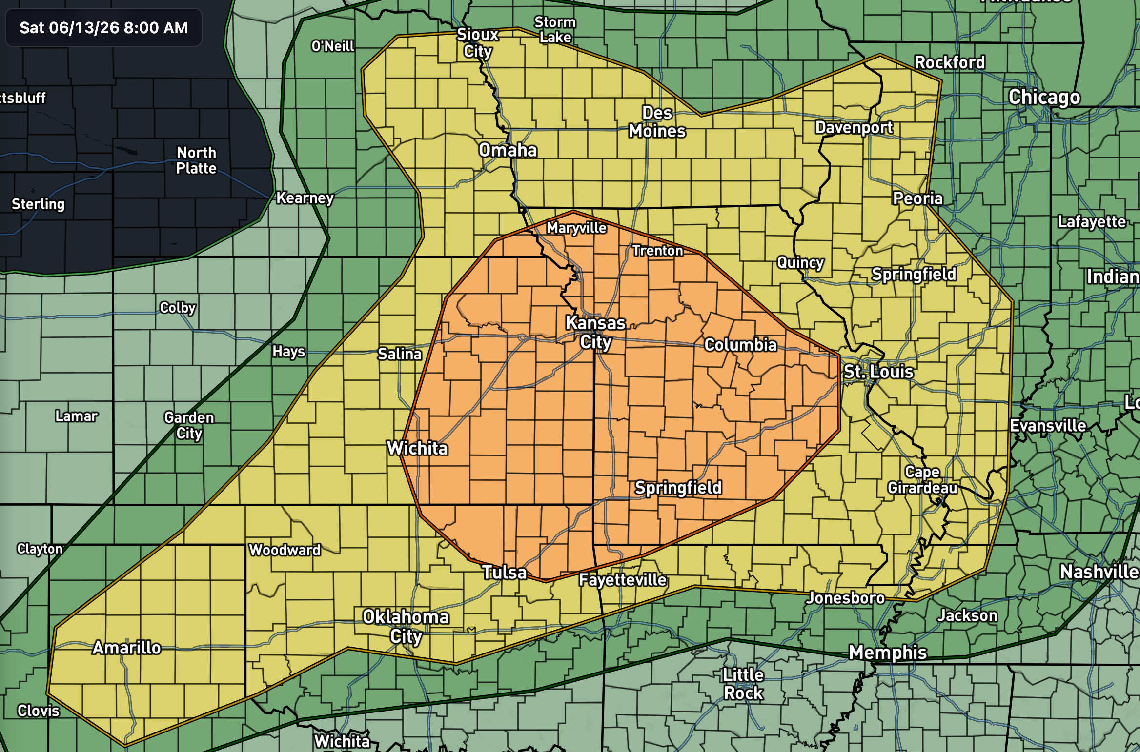
Moderate Risk in Place. SPC has an Enhanced Risk (level 3 of 5) for today covering eastern Kansas, much of western and central Missouri, and northeastern Oklahoma. Damaging wind is the headline threat, with large hail and a couple of tornadoes filling out the rest of the card. The evening hours along the cold front are the part of the day to circle.
We’re working in the base of a broad, large-scale trough draped across the northern CONUS, with a strong belt of midlevel westerlies running through it. An embedded shortwave (a smaller ripple in that flow) of positive tilt swings across the northern Plains through the day. At the surface, a weak low drifts slowly east across western and central Kansas before a cold front overtakes it this evening. That front is the main focusing mechanism for the better-organized storms later on.
The thermodynamics cooperate. Steep midlevel lapse rates, meaning temperature falling off quickly with height, which lets updrafts accelerate, sit on top of a rich, moist boundary layer. That stacking builds a strongly unstable air mass by peak heating. Effective shear around 40 knots is enough to organize storms into clusters and semi-discrete supercells.
Early in the period, a cluster of elevated storms tracks east from Nebraska into Iowa along the nose of a weakening nocturnal low-level jet. Steep lapse rates and 40 to 50 knots of effective shear favor large hail with that activity, though it stays mostly north of the main risk area.
Closer to the heart of the threat, a midlevel impulse and leftover convection push east from eastern Kansas into Missouri through the morning. Daytime heating of the moist air mass should build coverage and intensity along the resulting outflow into the afternoon. Moderate surface-based instability and 30 to 40 knots of effective shear support organized clusters and a few supercell structures, both capable of damaging wind and large hail.
Farther west, strong heating ahead of the surface low fires scattered storms from the central Plains into the lower Missouri Valley. These begin as semi-discrete supercells with large hail and locally damaging wind. As the cold front advances southeast into the evening, expect upscale growth into one or more organized clusters tracking east-southeast through a corridor of strong instability. That’s when the wind threat peaks, with some gusts potentially reaching 75 mph or higher.
Damaging wind. The evening upscale-growth scenario along the front is the primary concern, with the potential for a swath of strong gusts as clusters consolidate and ride the instability gradient east-southeast.
Large hail. Best odds with the more discrete storms earlier in the cycle, before everything congeals into lines and clusters.
Tornadoes. Lower-end but not zero. Despite the lean toward upscale growth, embedded supercells stay possible, and with ample low-level shear and rich moisture in place, a brief tornado or two can’t be ruled out.
Confidence is high that severe storms occur somewhere inside the Enhanced area. The wind and hail threats are well-supported by the instability and shear profiles. The open question is storm mode: how fast storms grow upscale into clusters versus how long they stay discrete. Some guidance leans toward earlier upscale growth, which tilts the day toward wind over tornadoes. If storms hold discrete longer than expected, the hail and tornado threats both tick up. Either way, the evening along the front is the time that matters.
This is a meat-and-potatoes Plains severe setup for mid-June: good instability, enough shear to organize, and a front to pull it together by evening. Nothing about it screams high-end, but Enhanced days earn their keep, especially after dark when storms are toughest to see coming. If you’re in the zone, keep warnings within reach tonight. I’ll update if the mode question tips one way or the other.
No posts
Comments
Nothing yet. Say the first thing.
Sign in to join the conversation.