
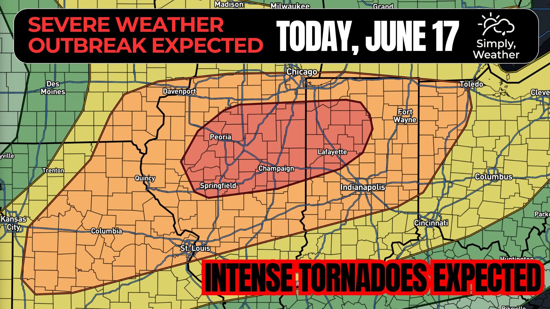
The Storm Prediction Center carries a Moderate Risk (category 4 of 5) from central Illinois into northwest Indiana, with a 15% hatched tornado probability. Hatched means a 10% or greater chance of EF2 to EF5 tornadoes within 25 miles of any point inside it, which is the language SPC reserves for days with real strong-tornado potential. The outlook is explicit: an outbreak of severe storms is expected, with intense tornadoes, damaging gusts to 80 mph, and hail to 2.5 inches. A second, lower-end corridor runs along the cold front from southeast Kansas into Missouri.
A strong mid-level jet streak (a core of fast winds aloft) overspreads the Midwest and lower Great Lakes today. A deep surface low over the Upper Midwest tracks toward the lower Great Lakes and into Ontario and Quebec through the period. Ahead of the trailing cold front, a strong low-level jet advects rich Gulf moisture northward, and a warm front, reinforced by this morning’s convection, lifts into central and northern Illinois and northern Indiana. The wind fields here are potent for mid-June. The Day 1 reasoning notes roughly 70 knots of mid-level flow, 100-plus knots at upper levels, and a 60-plus knot low-level jet. That combination of deep-layer shear and strong low-level shear is the kinematic backbone of the strong-tornado threat.
Convection is already ongoing this morning across eastern Iowa, riding the nose of the low-level jet. That cluster shifts east-southeast through northern and central Illinois into Indiana and carries a damaging-wind threat, but it begins in a drier, less unstable airmass with eastward extent and most likely weakens through mid to late morning. The more substantial threat develops by early to mid afternoon and depends heavily on how that morning activity evolves. Given the strength of the moisture advection, expect relatively rapid airmass recovery from the Quad Cities vicinity into central Illinois. Storms forming near the surface low and warm front in that window should be discrete and tap into strong low-level shear. The threat then continues eastward into Indiana through the evening, with low-level moisture improving with time, which means it does not end at sunset.
Mode is the whole story today. Discrete supercells near the warm front are the primary tornado concern, with large to very large hail, significant wind gusts, and strong to intense tornadoes all possible in the same storms. As activity congeals and pushes into Indiana overnight, expect a transition toward a more linear, damaging-wind-dominant structure, though embedded rotation and a tornado or two remain possible in that phase. Along the cold front from southeast Kansas into Missouri, storms should be supercellular for a few hours before the effective shear vectors, which have a large component oriented along the front, encourage upscale growth. Steep mid-level and low-level lapse rates there favor large to very large hail and 75-plus mph gusts, and despite sitting west of the low-level jet core, the low-level wind fields still support a tornado risk, some potentially strong.
This is the part worth slowing down on. The ingredients that produce significant tornadoes are stacking in the same place this afternoon: rich boundary-layer moisture pooling along a lifting warm front, strong storm-relative helicity (a measure of the spin available to a storm’s inflow) inside that 60-plus knot low-level jet, and a setup that favors discrete cells rather than a quick line. Discrete supercells in a high-shear, moisture-rich warm-frontal environment are the classic recipe for strong, long-track tornadoes. The hatched 15% is SPC telling you the EF2-plus potential is not hypothetical today.
Pattern confidence is high. The jet structure, the surface low, and the moisture return are locked in, and the broad footprint of a significant severe day is not in question. Placement confidence on the discrete tornado threat is lower and tied to one lever: how cleanly this morning’s convection exits and how much the airmass recovers behind it. If the morning storms scour out the warm sector or leave widespread cloud cover, the afternoon underperforms. If the sun comes out behind them across central Illinois, that is where the most dangerous storms go up. Watch the warm front position and the clearing line through midday. That is your tell.
If you are in the risk area, today is a day to have multiple ways to receive warnings, especially ones that will wake you tonight, and to know your safe place before a warning arrives.
No posts
Comments
Nothing yet. Say the first thing.
Sign in to join the conversation.