
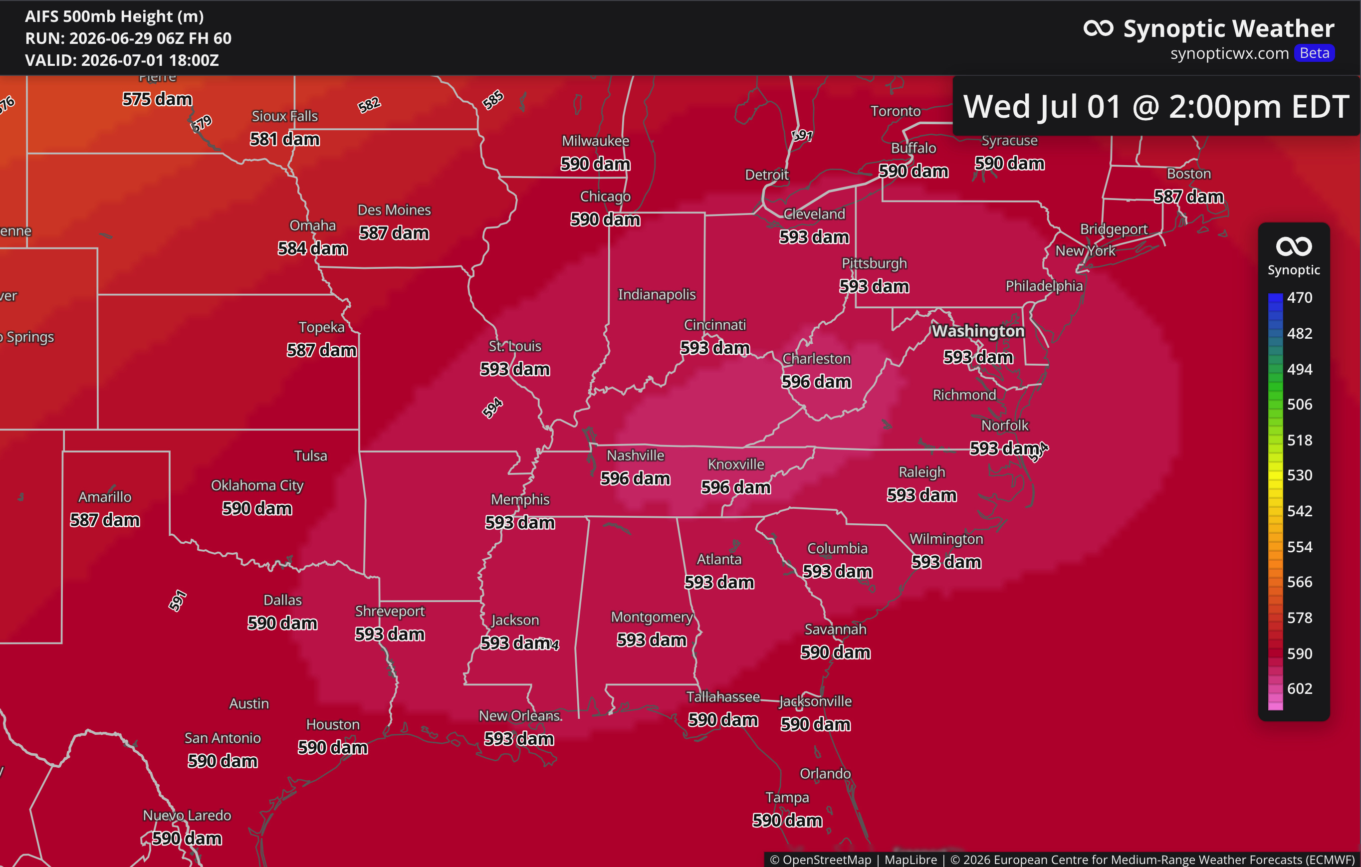
A strong upper-level ridge, a textbook heat dome, has taken over the eastern half of the country and holds through at least Thursday. Somewhere around 230 million people sit under dangerous heat, with heat index values of 105 to 110 across a wide swath from the Midwest to the Mid-Atlantic. The headline is not really the afternoon high. It is the combination of relentless daytime heat, oppressive humidity, and overnight lows that refuse to drop, several days in a row.
The Synoptic Setup
This is a dipole pattern, two opposite features working as a pair. A deep trough (a southward plunge in the jet stream) has dug into the Pacific Northwest and the West, dropping temperatures there and, unfortunately, ramping fire weather back up across Utah, Colorado, and Arizona as winds pick up. Downstream, the flow amplifies into a tall ridge of high pressure over the eastern US. Mid-level heights are building into the 594 to 596 decameter range, which is a very strong ridge for this part of the country.
The ridge is the engine. Beneath it, the air subsides, meaning it sinks. Sinking air warms adiabatically (it heats up simply from being compressed as it descends), it caps off cloud development, and it leaves the surface exposed to full late-June insolation with the longest days of the year doing the rest. The anticyclonic flow around the ridge also chokes off some of the deep Gulf moisture transport, which is why a few areas closer to the Appalachians may trend toward a drier heat. For most of the footprint, though, low-level moisture is plenty high, and that is what drives the heat index well above the air temperature.
Timing and the Westward Drift
The dome’s eastern flank pushed into the Midwest and Great Lakes Monday and Tuesday, with Chicago and the Ohio Valley seeing heat index values near 110. The Northeast loads up Tuesday into Thursday, with Washington, Philadelphia, and Richmond in the mid to upper 90s and the feels-like climbing to 100 to 110. Some forecasts put Philadelphia near the century mark on multiple days and Washington at or above 100 for as many as four. Late this week the ridge axis retrogrades, drifting back toward St. Louis and then toward the Four Corners into next week. That retrogression is what eventually opens the door for relief in the East, New England first, the Mid-Atlantic last.
Why the Overnight Lows are the Story
The National Blend of Models is signaling widespread record high minimum temperatures across much of the eastern US, with lows only sinking to the mid or upper 70s and the big-city heat islands holding near or above 80. Pavement, brick, and concrete soak up solar energy all day and bleed it back out after dark, and the long July-adjacent nights are too short to flush it. Physiologically, this is the dangerous part. The human body relies on the overnight dip to recover. Remove that recovery window for three, four, five nights running and core heat load accumulates, which is the mechanism behind most heat-related deaths. This is why heat is the deadliest weather hazard in the country in an average year, and it does it quietly.
Confidence and What Could Change
Pattern confidence is high. The ridge is real, it is strong, and the multi-day heat is locked in. The lower-confidence piece is the timing of the breakdown. Models agree the dome retrogrades west toward the holiday weekend, but exactly when each city crosses back to the cool side is still in play. Boston may turn the corner before the Fourth. Washington may not get there until late on the Fourth or into Sunday. The other lever is the ring-of-fire convection riding the periphery of the ridge, storm complexes tracking from the northern Plains into the Great Lakes and Northeast, plus Gulf Coast storms. Where those clusters hit, they can shave a few degrees off an afternoon, but they are hit-or-miss and not a reliable break.
One bit of context worth keeping honest: this is happening at the same time Europe sits under its own heat dome, a blocking pattern that has been breaking June records from Spain to the UK. Two major heat domes on both sides of the Atlantic in the same week is unusual, and the long-term trend toward more frequent and more intense heat is well established in the data.
For now, treat the nights as seriously as the afternoons, check on the people who do not handle heat well, and find your cooling option before you need it.
No posts
Comments
Nothing yet. Say the first thing.
Sign in to join the conversation.