
Recently a report on the biology of Blood Run became available. It’s packed with valuable details about specific species and their organization into plant communities. Although “ethnobotany” usually focuses on uses of plants rather than the distribution of plants, it would have been appropriate to have at least some mention of Native American perspectives. After all, the status of the National Historic Landmark is based on the Native American aspects of the landscape. In contrast in the last post, we looked at an example of an approach to landscape research that starts with the cultural perspectives available from Native Americans, especially the descendants of the people who once lived at Blood Run. That would be the Dakota, Omaha, Ponca, Iowa, and Ho Chunk people now living in the Big Sioux and Missouri Watersheds.
The biology report pretty much follows standard “scientific” methodology to provide a useful base line of taxonomic information. The report also provides recommendations for management using fairly conventional conservation practices. Although it mentions prescribed burning, grazing, mowing, and interseeding, the recommendations tend to emphasize spraying herbicides. That’s an unfortunate short-term eradication rather than taking the long view of a multi-generation approach. The data collection and recommendations would have benefitted from indigenous perspectives because conventional “colonial” conservation practices tend toward the gratification of seeing immediate results. Those conservation practices rely on the standard recipe of “mow-it, spray-it, plow-it, and plant-it”. There are other ways to do things.
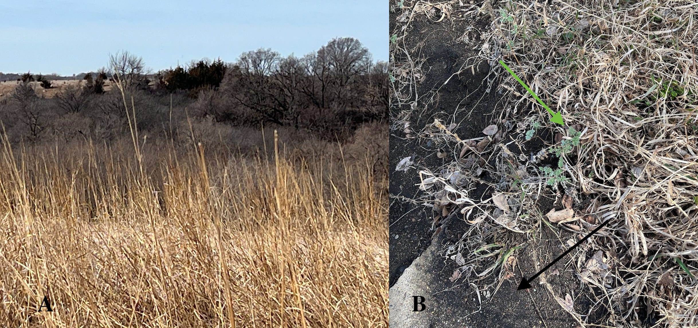
Figure 1----Photos from my “walkabout” on the first day of Spring. A) Dry big blue stem and the view across Blood Run Creek. B) Green sage (green arrow) at the end of the abandoned sidewalk (black arrow).
Things were all pretty brown when I visited Blood Run last month. This view (Figure 1-A) is taken from the southwest corner of the restored prairie on the upland above the Sacred Spring. The native grass in the foreground is dead and dry and there are no leaves on the trees on the slope leading up to the main mound group across the creek. There are invasive buckthorn shrubs around those trees and the dark green cedar trees on the upper part of the slope may also be perceived to be a conservation “problem”.
However, the Spring season is inescapable! There’s also a touch of green “where the sidewalk ends” (remember the kids’ book by Shel Silverstein?) near the renovated Sacred Spring (Figure 1-B). I thought that this early green plant was sage, but the biology report raises some doubts about that. In fact, there’s confusion and controversy about exactly what species of sage is the one that is sacred for Native Americans. But, before we explore that mess, let’s take a look at the map of plant communities that are present in the Blood Run NHL.
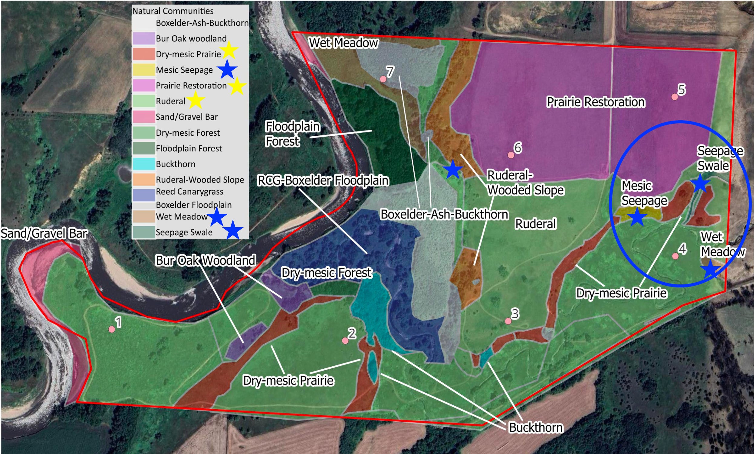
Figure 2----Map of plant communities in Blood Run National Historic Landmark (Marty, Harry, and Griggs, 2025).
There are fifteen natural communities of plants shown on this map. About half mainly have trees and we’re not going to discuss those. Similarly, there are seven stations marked with pink dots where observations of bird populations were made; we’re not going to talk about those either. We’ll concentrate on the Dry-mesic Prairie, the Prairie Restoration, and the Ruderal (yellow stars, Figure 2). In addition, we’ll look at the Mesic Seepage, the Wet Meadow, and the Seepage Swale (blue stars, Figure 2) in some detail. The blue circle emphasizes the concentration of those wet communities at the eastern side of the study area.
The Dry-mesic Prairie is a remnant prairie generally confined to the hillslopes that are marginal to the uplands. That’s a pattern that we also saw across the river in Good Earth State Park. One of the upland surfaces is host to the Prairie Restoration in the northeastern part of the study area. But by far the largest area is covered by the Ruderal community that extends as a mass of green throughout the map. “Ruderal” is not a term that I was familiar with. Wikipedia says that ruderal species are the first to colonize land disturbed by humans or natural events. In Blood Run the mapped Ruderal Community includes the Big Sioux floodplain (around bird station1, Figure 2), the main mound group (station 2), the “restored” abandoned gravel pit (between stations 3 and 6), and the floodplain along Blood Run Creek (station 4). So, it covers a wide variety of landforms.
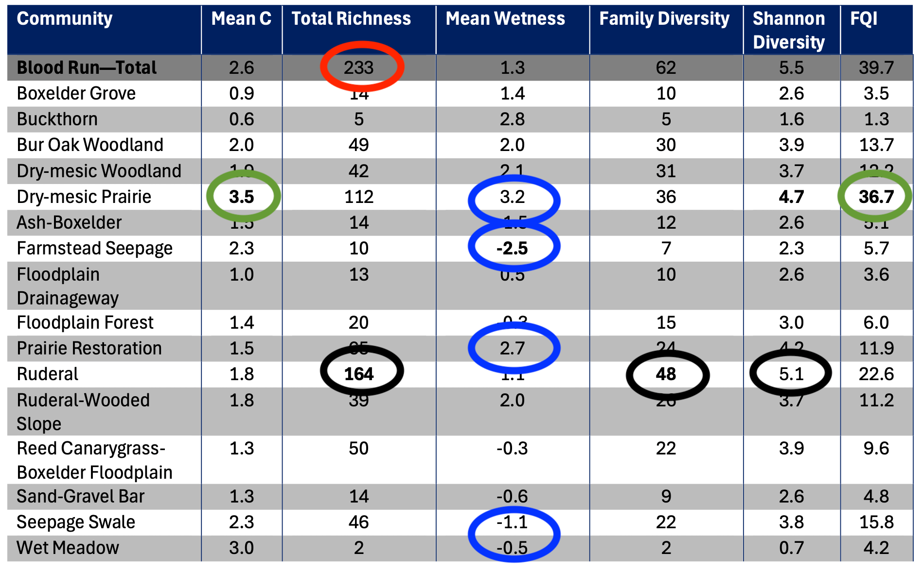
Figure 3----Table summarizing the results of ecological assessment for each plant community (Marty, Harry, and Griggs, 2025).
My apologies for dumping a whole lot of numbers on you. It’s easiest to show you the whole summary table (Figure 3), but we’ll focus on just the few communities. But first there are some general things to talk about. The data appendix of the report lists 261 individual species and about half of them are non-native invasive plants. “Total Richness” in Figure 3 is defined as the ….”total number of plant species in this community”. I’m not clear why that total for Blood Run is tabled at 233 (red circle, Figure 3) rather than 261. Maybe the calculations for other table components are based on those 233 species?
But let’s focus on some specific plant communities. We’ll start with the Ruderal Community; it has the highest Total Richness, Family Diversity, and Shannon Diversity (black circles). That means that it has the largest total number of plant species and families spread evenly over the area. Maybe those high scores in part reflect the fact that this is a very large area? In contrast, the remnant Dry-mesic Prairie Community has the highest Mean C and FQI (green circles), which are measures of ecological quality and similarity with the original prairie plant communities. The numbers for the Restored Prairie Community are all relatively low which I would intuitively expect to be close to the remnant Dry-mesic Prairie Community. The Mean Wetness (-5 is wettest and +5 is dryest) has the expected higher values for the Dry-mesic Prairie and Prairie Restoration and lower values for the Farmstead Seepage, Seepage Swale and Wet Meadow (blue circles).
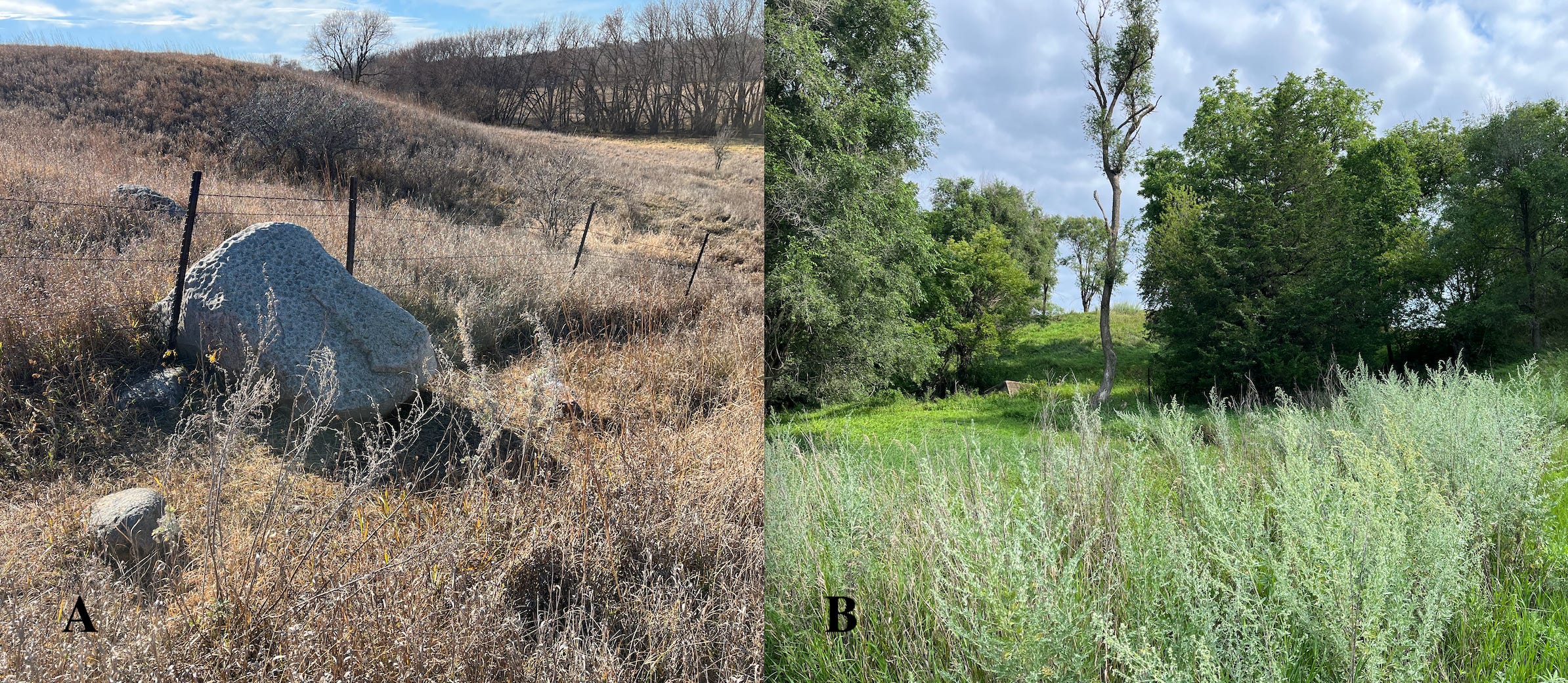
Figure 4----Photos of sage at iconic archaeological surface features in Blood Run NHL. A) Pitted Boulder on the first day of Spring, 2026. B) Sacred Spring late this past summer.
We’re going to pay particular attention to sage because I went on a hunt for it here in Blood Run. The biology report says (p. 23) that the Dry-mesic Prairie is the only community that has sage. The Pitted Boulder is located in the Dry-mesic Community and does have sage (Figure 4-A). But on my hunt, I found what I thought was sage at several places in the area of the mapped Ruderal Community (Figure 2) including the Sacred Spring (Figure 4-B). However, maybe I’m not doing the plant identification correctly or maybe there are other varieties of sage? The report says that it’s white sage that’s only found in the remnant Dry-mesic Prairie.
I remember hearing a story about a panel discussion at a meeting of professional archaeologists that was organized to talk about the importance of sage in Native American cultures. The storyteller was amused that the conversations stalled because they were basically arguing about what “sage” was! There are probably several different kinds of sage that may have different cultural purposes. We should ask the ancestral descendants.
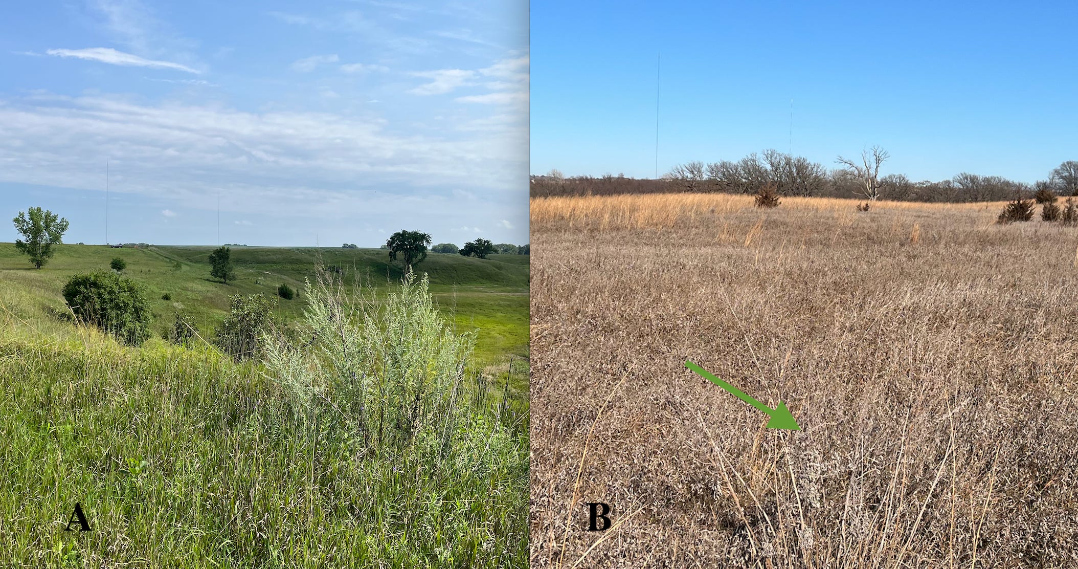
Figure 5----Photos of sage in the Ruderal Community. A) Late last Summer on a hill where significant cultural material has been observed. B) First day of Spring, 2026 on a mound in the main mound group (green arrow points to the subtle silvery sage).
A couple other examples of what I thought was sage are shown in Figure 5. Like the Sacred Spring, both of these locations are in the mapped Ruderal community. The question is: are these definitely white sage or is white sage found in communities other than the Dry-mesic Prairies preserved on the steep hillsides? That’s probably also a question about the viability of the Ruderal community as a functional map unit. It feels like it’s more of a “grab bag” of what’s left over after the other more diagnostic communities are defined and mapped.
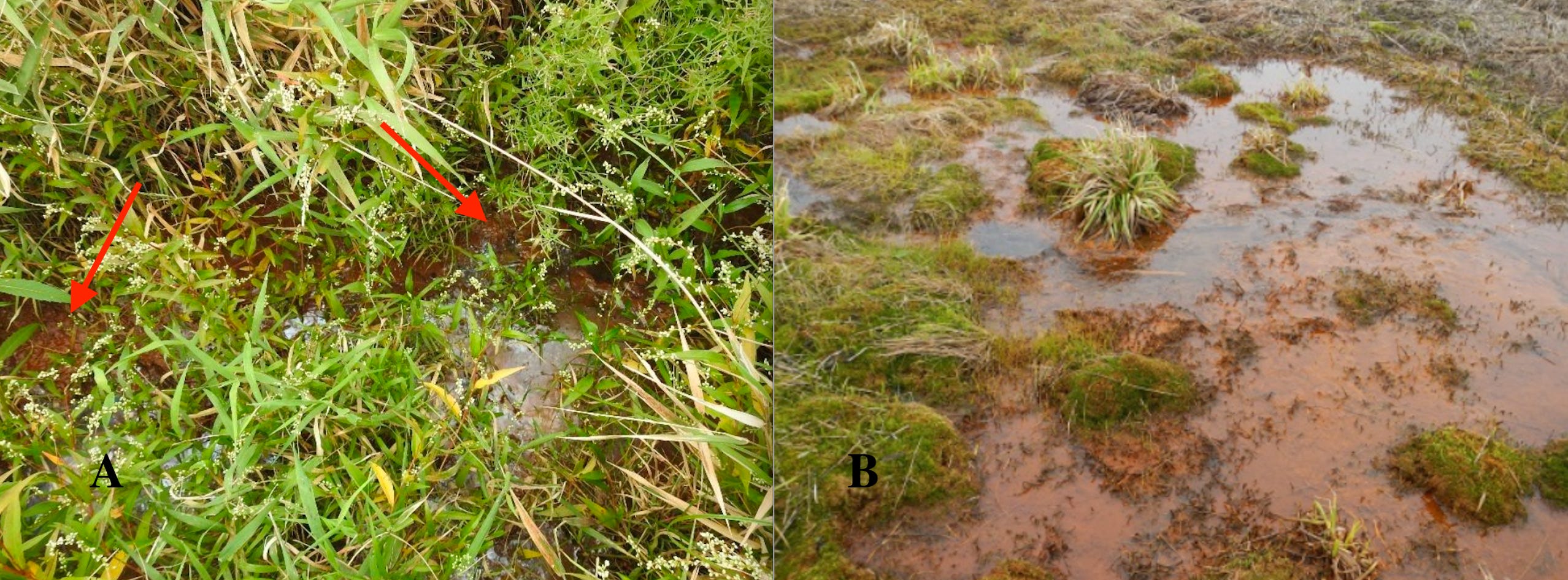
Figure 6----Photos of rust-colored iron oxide deposits associated with springs. A) Blood Run NHL (Marty, Harry, and Griggs, 2025). B) Southwestern Minnesota (Minnesota Board of Water and Soil Resources, 2014).
I think that one of the most important and interesting aspects of the biology report is the identification of the several wetland communities on the eastern map margin (blue circle, Figure 1). Those communities strongly suggest that there’s another complex of natural springs located in the Blood Run NHL, in addition to the Sacred Spring. I don’t recall ever visiting that area, but I definitely intend to now! I’d like to see that rust-colored iron oxide (Figure 6-A) and the groundwater seep that produces it. There have been lots of ideas about the origin of the name “Blood Run”, but one persistent one has been iron oxide associated with the water. The biology report documents a plant community that’s been identified with iron staining in a nearby state (Figure 6-B). For me that confirms the name origin because there are no known outcrops of red rock and no known battlefields. But we can see the rust-colored sediments and that explains how Blood Run Creek probably got its name!
The report does raise some interesting questions: 1) Is the Ruderal Community a useful map unit? It covers a variety of landforms over a very wide area and includes a lot of native as well as invasive plant species. 2) Are there several different varieties of sage or have a number of occurrences been overlooked? 3) How extensive is the iron staining in the wet communities on the eastern side of the map area? 4) Are there other seeps and springs that have not been recognized in the NHL?
In summary, this biology report has lots of technical taxonomic information potentially useful in understanding the landscape and also has some suggestions about conservation practices. However, any Native American perspective is conspicuously absent. Of course, that may not have been part of the original request for proposals (RFP), but the oversight is striking for a National Historic Landmark based on archaeological significance. Ideas provided by the living descendants of the Oneota culture would have added a powerful component toward understanding both the landscape and potential approaches to conservation management.
No posts
Comments
Nothing yet. Say the first thing.
Sign in to join the conversation.