
A regular reader of this Substack posted a comment on the last essay that really resonated with me. She asked, “Think before dig?” That’s a perfect summary of the “See-Count-Dig-Think” recipe for archaeology that came out of our world tour! It also reminds me of the “Call before you dig” advertising that conjures up images of folks in fluorescent vests putting flags up in and around construction sites. The summary cuts through any of the possible confusion dealing with the circles and numbered, curved red arrows that were used in an attempt to illustrate the recipe. I hope that you stuck it out reading that post long enough to down get into the example of alignments, measurements, and counting that we looked at in Gitch Manitou State Preserve located a couple of miles north of Blood Run National Historic Landmark (NHL). Because that’s what we’re going to do at Blood Run in this post.
The discussion at Gitchie Manitou involved measurements and counts of mounds in two well-documented alignments. The measurements suggested the “Hopewell Measurement Unit” (HMU = 1,054 feet or 321.3 meters) may be an integral aspect of the site and that mounds are clustered in groups of 4 which is a number with cultural significance for Siouan speakers. The contemporary Dakota, Omaha, Ponca, and Ho Chunk people currently living in the Big Sioux Watershed are the descendants of traditions that share a heritage of ties back to the Hopewell sites in the Ohio River Valley and to Cahokia in the Mississippi River Valley. We will see that the number 4 and the HMU are also present at Blood Run NHL and that in addition there’s evidence for another measurement unit called the “Cahokia Yard” (3.425 feet or 1.044 meters). All of these “Counting” exercises were done in the context of the first day of Spring (the Vernal Equinox in “science speak”) so we’ll also have an update on recent changes at Blood Run NHL.
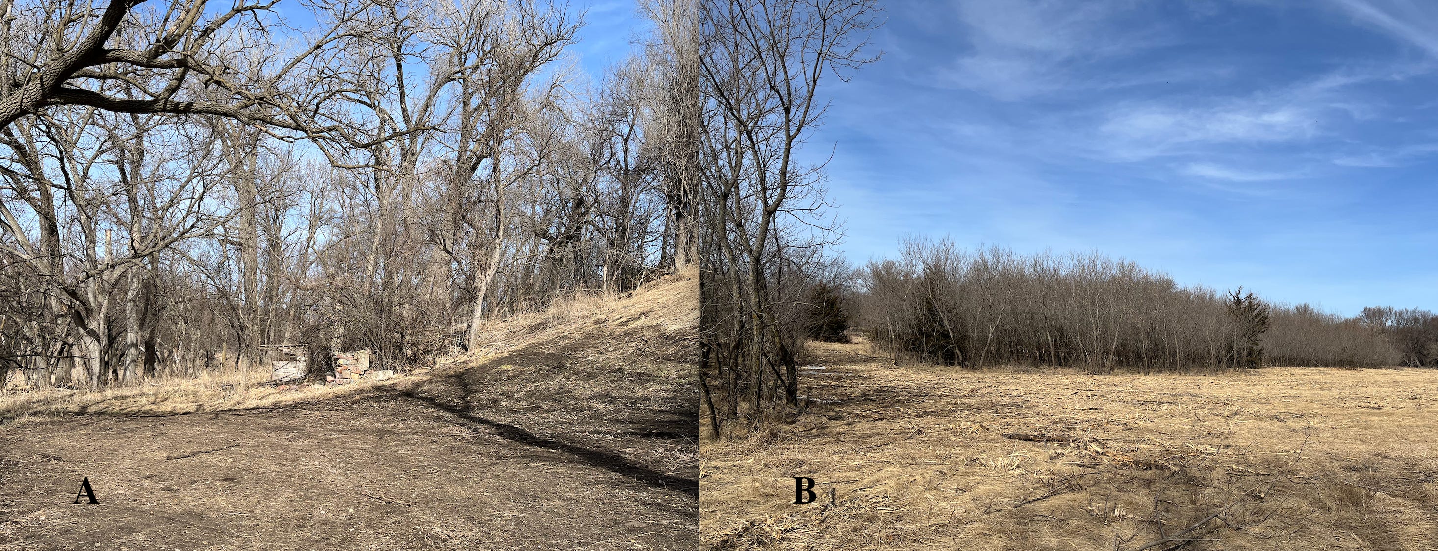
Figure 1----Photos from my walkabout on the first day of Spring. A) Status of the modifications at the Sacred Spring. B) Aftermath of the removal of small trees on the floodplain and terrace west and south of the Sacred Spring.
Things are still pretty brown along the Big Sioux River, but it’ll be greening up soon. Early last Fall the Sacred Spring at Blood Run was freed from a confining concrete foundation and returned to a somewhat more natural state. Although there was initially moisture seeping to the surface, this Spring the area is dry (Figure 1-A). It’s dry everywhere! There was more activity last Winter when the ground was relatively frozen. A state agency came in with a machine that essentially “mowed down” a field of small trees that had originally been planted as a part of conservation efforts. The remaining trees were probably too big for the machine to handle, but you can see where the process left light-brown debris to the right of the larger trees (Figure 1-B). I’m not sure what’s planned next, but we’re now headed across the creek on the new bridge to look at “counts” in the main mound group.
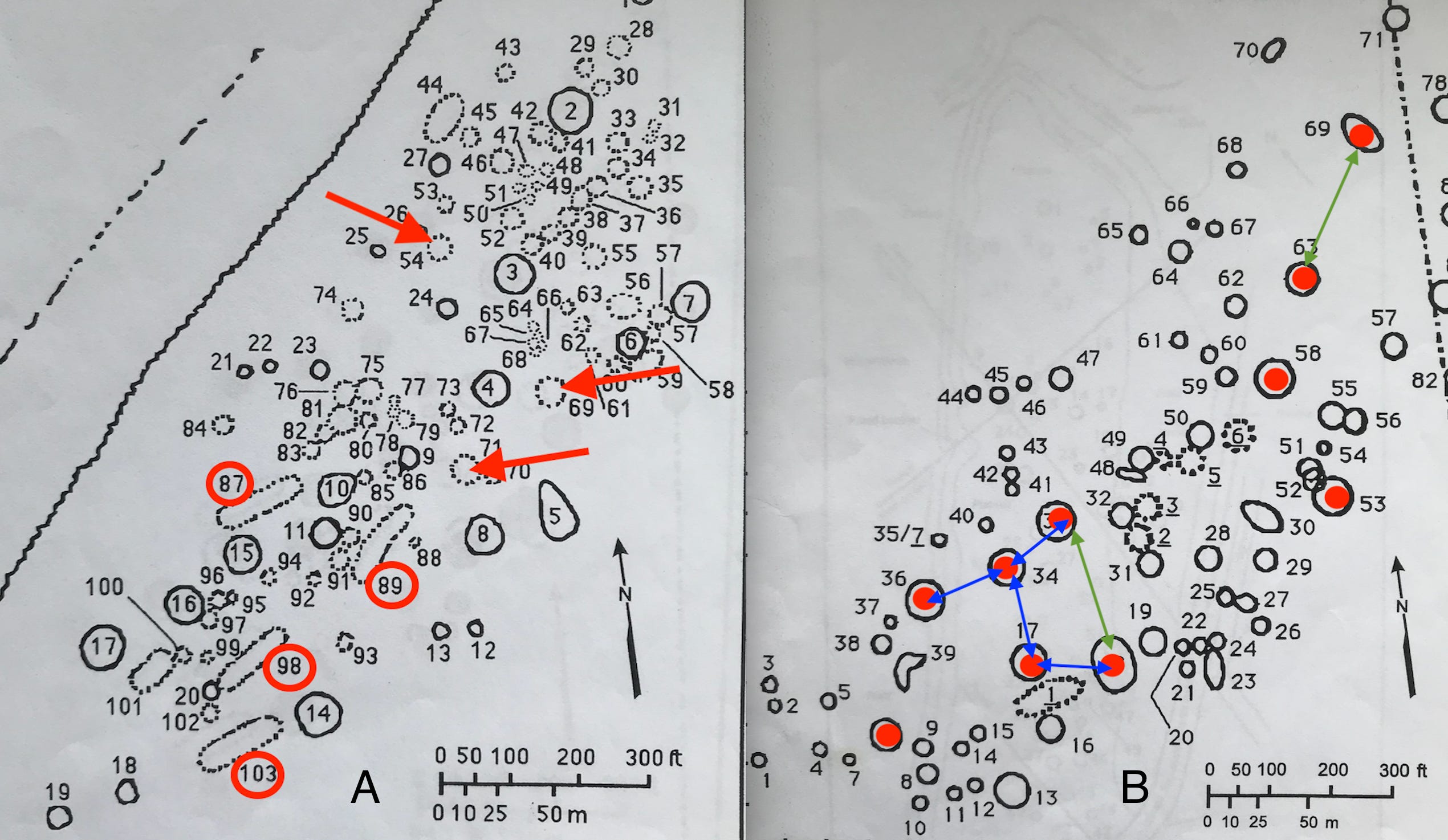
Figure 2----Historic maps of the main mound group at Blood Run NHL. A) Cahokia Yards seem to be used in the elongate boulder outlines with circled numbers and boulder counts divisible by 4 are marked with arrows (Pettigrew, 1889). B) Some large mounds with red dots are separated by 1/4 or 1/8 Cahokia yard (Lewis, early 1890s).
Two historic maps are available in a published compilation (Lueck and others, 1995) that includes tables of dimensions and counts of boulders. The oldest map (Figure 2-A) has outlines of boulder arrangements as well mounds. There are five elongate boulder outlines and four of those have at least one dimension that conforms with whole number multiples (specifically, multiples of 4) of the Cahokia Yard. In addition, there are boulder counts for four circular outlines and three of those have whole number multiples of the number 4. A slightly newer map (Figure 2-B) has 10 large circular mounds with diameters greater than 50 ft. Four pairs of those mounds are separated by distances equivalent to 1/8 Cahokia Yard (blue arrows) and two pairs are separated by 1/4 Cahokia Yard (green arrows). There may be other distances that can be recast in equivalents of Cahokia Yards divided by multiples of 4, but this first look at just the largest mounds suggests that the potential is there to keep hunting. The marked items in Figure 2 are only diagrammatic; accurate distances should be measured on the ground or using geographic information systems (GIS).
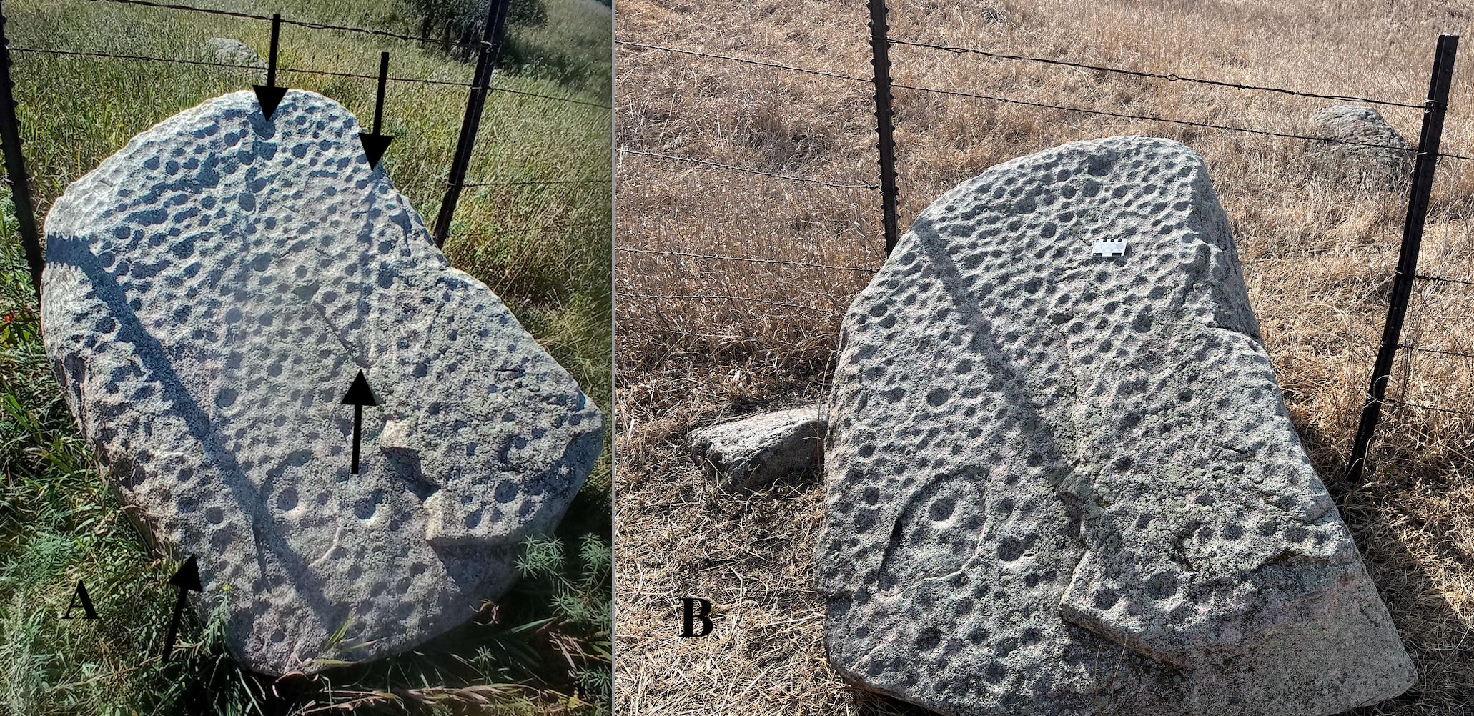
Figure 3----Pitted boulder. A) At noon around the first day of Fall, 2023. Photo by Jim Zangger. B) At noon the first day of Spring, 2026. Photo by George Shurr.
One of the most prominent surface features in Blood Run NHL is the iconic Pitted Boulder (Figure 3). Although there’s been a lot of speculation about why the “cups” were put into the boulder, there seems to be some pretty clear astronomical significance. I’ve described observations made by Jim Zangger on the first day of Winter and also on the first day of Fall (Figure 3-A). The linear shadows weren’t as conspicuous on my walkabout last week (Figure 3-B). Maybe that’s because the camera angle was different or possibly because the “noon” times weren’t exactly the same.
However, I did measure a compass orientation on the relative flat sides on the east and west sides of the boulder, and both are very close to trending north-south. That’s probably important if this is a marker for observations made on equinox days. In addition, a local farmer counted 753 pits or “cups” on the boulder back in the day (Henning and Schermer, 2004, p. 433). If he counted one cup twice, the number 752 is divisible by 4. If he missed three cups, the number 756 is a multiple of 4 and of 7. Both 4 and 7 have important cultural significance in the traditions of the descendants!
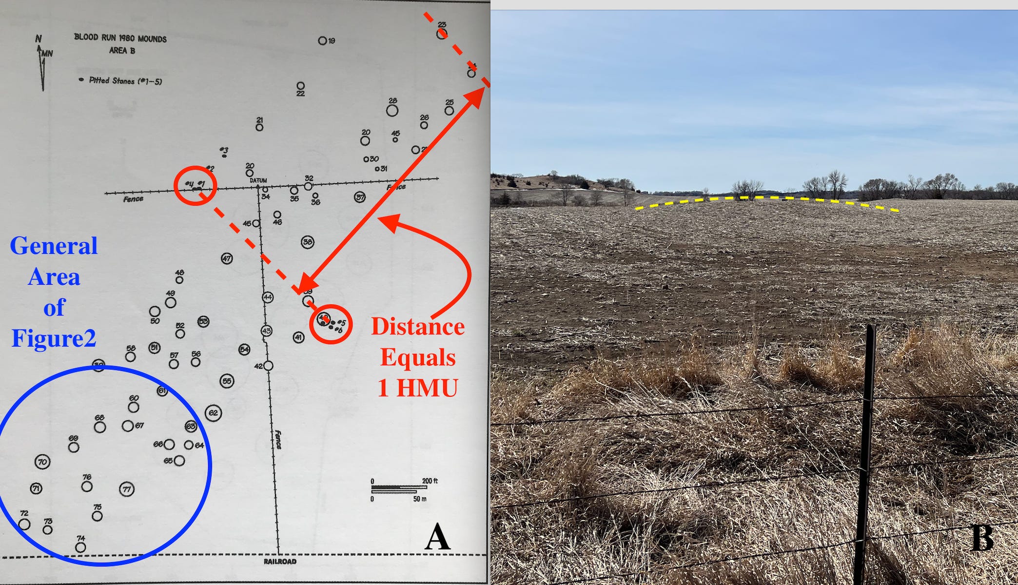
Figure 4----A) One HMU in the north part of the main mound group. Map modified from Henning and Schermer, 2004. B) Mounds in the cultivated field, March 20, 2026. Photo by George Shurr.
The Pitted Boulder anchors the northwest end of a line that subdivides the main mound group into “neighborhoods”. The southeast end of the line is a cluster of several smaller pitted boulders (Figure 4-A). The distance from that line to the northeast end of the mound group is equivalent to 1 HMU. I tried to find multiples or 1/4 fractions of HMUs to the southwest toward the general area of Figure 2, but there didn’t seem to be anything that was an easy fit. The photo in Figure 4-A shows the mounds in the cultivated field; it was taken along the fence just to the east of the Pitted Boulder. I added the yellow dashed line on one mound because they’re not all that easy to see. And every year field cultivation wears them down a little more. The main mound group is still not protected!
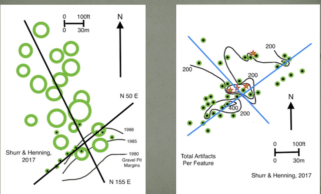
Figure 5----Linear patterns in the north mound group. A) Mounds and circular features at the gravel pit edge. B) Linear patterns in circular features.
The mound group north of Blood Run Creek was partially destroyed by gravel pit operations in the 1980s. But there are linear patterns preserved in both the mounds and in the small circular features that were storage and trash pits with concentrations of artifacts. Although I looked for HMU multiples or fractions in the distribution of mounds (Figure 5-A), I couldn’t find any obvious ones. Naturally, only part of the overall length is preserved, but I couldn’t find any HMU multiples or fractions across on the widths either. Maybe need to “sort” mounds further by size or multiples of 4 like we did down in the main mound group?
Measurements are available (Henning and Schermer, 2004) for the small circular features excavated as a part of salvage operations (Figure 5-B). There are eighteen that have a depth of greater than 1.64 feet (.50 meters) and those eighteen have an average diameter of 6.76 feet (2.06 meters). Two “Cahokia Yards” would be 6.86 feet (2.09 meters) so the average diameter of the eighteen features is “about” that value. The similarity is not statistically significant at the 95% probability level, but in my experience that significance level is pretty rare in field observations. Sometime I should probably “suck it up” (I hate statistics!) and find out at exactly what significance level the two numbers are similar.
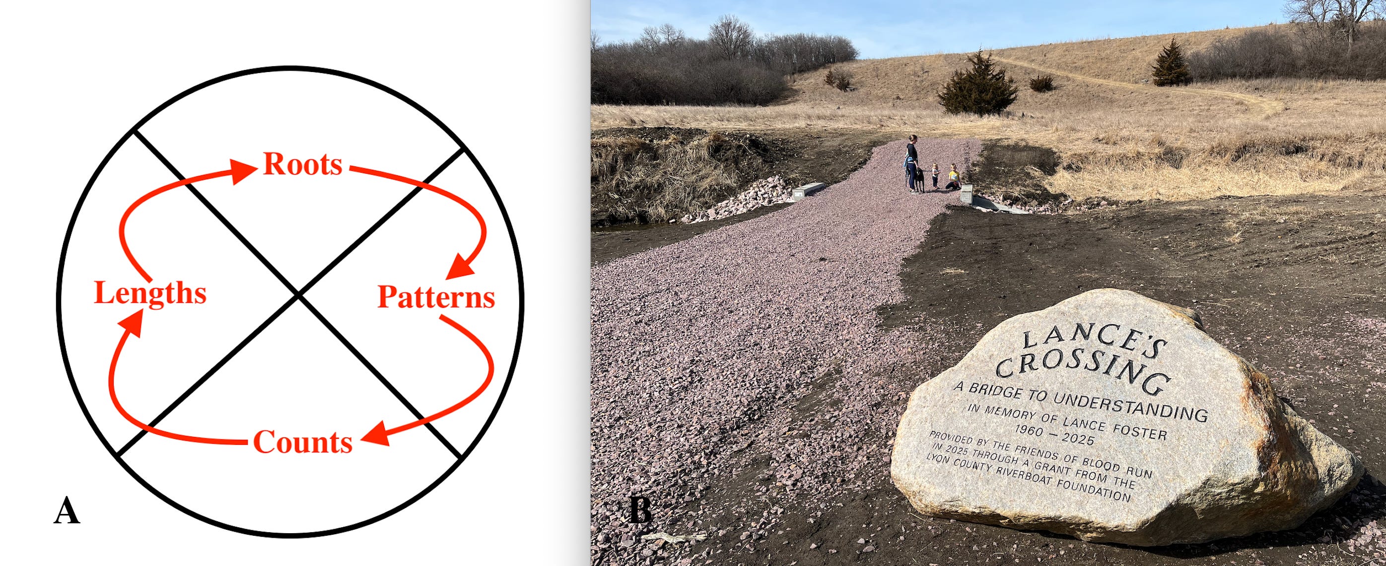
Figure 6----A) Summary of the hike around Blood Run after the first day of Spring. B) New bridge with boulder marker and visitors.
Here’s the bottom line (Figure 6-A). The people who once lived here have descendants still living in the Big Sioux Watershed. And those descendants carry shared traditions of linguistic and cultural Roots back to the centers at Cahokia and Hopewell. We can still see the Patterns in the landscape that people observed and then replicated in the Counts and Lengths of the alignments and mounds that they constructed.
Good Earth/Blood Run will continue to mean a lot in people’s lives. On my hike on the first day of Spring, I encountered a young family enjoying the day at the new bridge that now crosses Blood Run Creek (Figure 6-B). There’s also a new boulder that’s a landmark dedicated to the memory of Lance Foster who passed away last year. It’s good to know that there’s a Place that honors Nature and the People who have lived here in the past and who are living here now. In these unsettled and troubling times, we need a Place like this.
No posts
Comments
Nothing yet. Say the first thing.
Sign in to join the conversation.