
Introduction
For over a century, the dominant narrative surrounding Neanderthal spatial behavior was cast in the mold of structural chaos. Early twentieth-century taphonomic models characterized Homo neanderthalensis residential sites as disorganized accumulations of refuse—haphazard lithic scatters mixed with broken animal bones centered around ephemeral, unmaintained fires. Under the lingering dogmas of the “Cognitive Rubicon,” structured domestic space, discrete waste management, and dedicated activity zoning were considered exclusive hallmarks of Homo sapiens behavioral modernity. Neanderthals were depicted as opportunistic brutes who lived, worked, and slept directly within their own discarded debris.
In my view, this paradigm is fundamentally untenable. Over the last two decades, a quiet revolution in spatial archaeology—driven by micro-stratigraphy, thin-section micromorphology, micro-botanical phytolith mapping, and comprehensive lithic refitting—has shattered this disorganized trope. When we analyze Neanderthal occupation surfaces not as crude, time-averaged palimpsests, but at the millimeter scale, an extraordinary level of spatial discipline emerges.
At the core of this spatial architecture lies the hearth. Far from being a passive source of thermal energy, the Neanderthal hearth functioned as the structuring node of the domestic environment—a cognitive anchor around which task-specific labor, sleeping zones, and refuse management were systematically organized. In this paper, I present a rigorous analysis of high-resolution micro-spatial data from three critical site complexes: Abric Romaní (Spain), Tor Faraj (Jordan), and Grotte du Lazaret (France). By evaluating raw micro-morphological evidence, phytolith distributions, combustion dynamics, and ethnoarchaeological drop/toss models, I demonstrate that Neanderthals possessed sophisticated spatial cognition, actively managing their living floors with intentionality, structural modularity, and behavioral complexity that rivals contemporary Homo sapiens hunter-gatherers.
Context
The study of hominin spatial organization requires exceptionally high-resolution sedimentary environments. Cave and rock-shelter sites across the Western Palearctic offer ideal taphonomic conditions where rapid sedimentation rates preserve discrete occupation surfaces before post-depositional bioturbation can erase human spatial signatures. Three key site complexes provide the empirical bedrock for our spatial reconstruction:
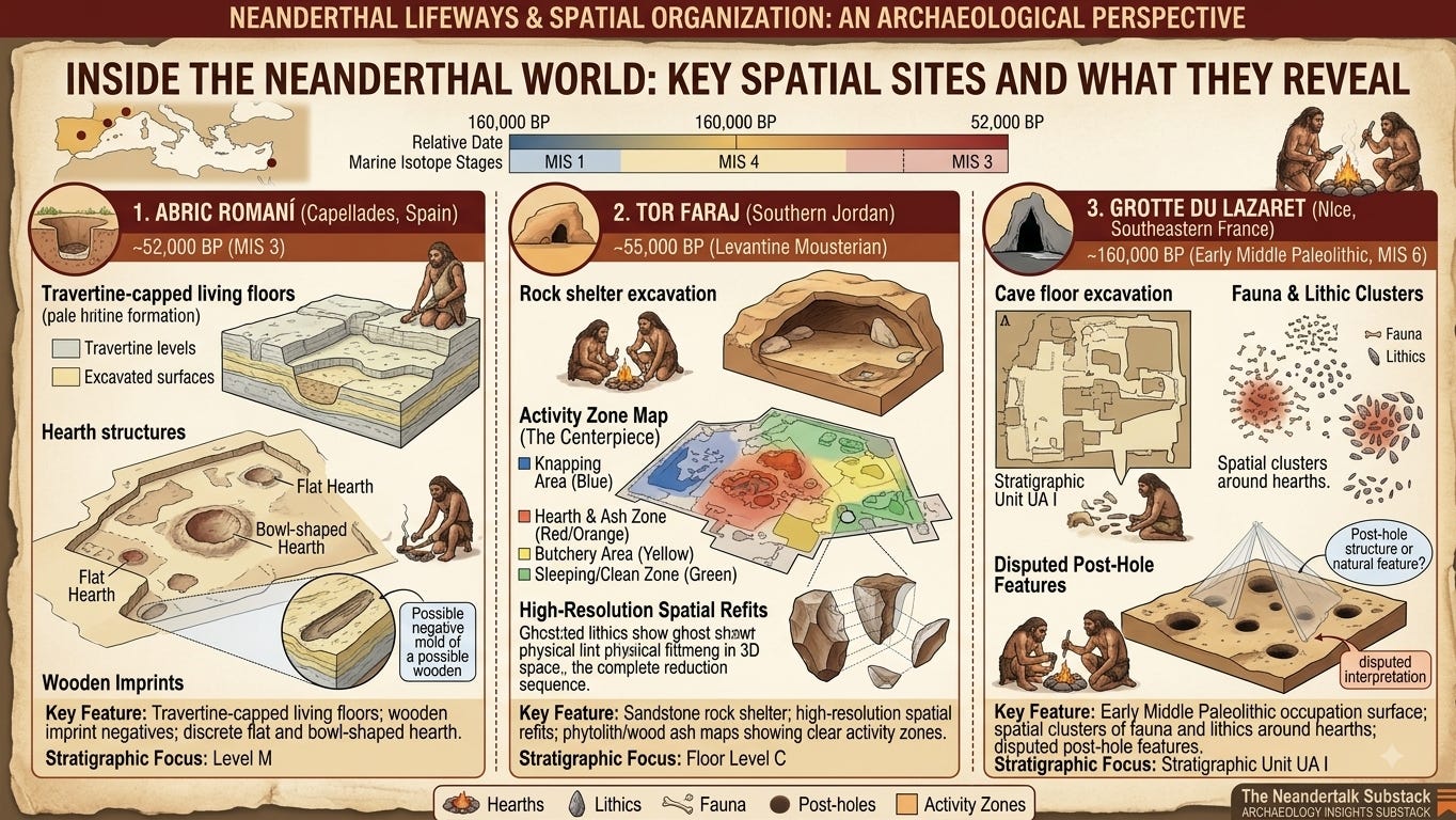
Abric Romaní (Capellades, Catalonia, Spain)
Abric Romaní is a rock shelter situated 300 meters above sea level in the Anoia river drainage. The site features a 17-meter-thick stratigraphic sequence dominated by rapid tufa and travertine deposition fueled by carbonate-rich spring water. This unique hydro-geological setting effectively “encased” individual Neanderthal occupation surfaces in fine-grained calcium carbonate crusts shortly after abandonment. Level M, dated via Uranium-Series and Radiocarbon methodologies to approximately 52,000 years before present (52 ka BP), represents a pristine, short-term residential event. The rapid burial preserved not only lithics and calcined bones, but also the delicate carbonaceous imprints and pseudomorphs of wooden structural elements and hearth remnants.
Tor Faraj (Ramm Desert, Southern Jordan)
Tor Faraj is a prominent sandstone shelter in southern Jordan containing deep Levantine Mousterian deposits. Floor Level C, dated to roughly 55,000 years before present (55 ka BP), provides a rare, uncompressed horizontal exposure of a Neanderthal living floor. Because the matrix consists of fine, wind-blown quartz sands and micro-grained spalls from the sandstone roof, post-depositional cryoturbation and bioturbation are minimal. The site offers an exceptional spatial canvas for testing spatial autocorrelation hypotheses via lithic refitting and micro-botanical mapping.
Grotte du Lazaret (Nice, Southeastern France)
Grotte du Lazaret represents an earlier window into Middle Paleolithic spatial dynamics, situated within Marine Isotope Stage 6 deposits dated to approximately 160,000 years before present (160 ka BP). Stratigraphic Sub-unit UA 25 has long been at the center of spatial debates due to early claims by Henry de Lumley regarding the existence of a constructed “tent-like” skin structure anchored by perimeter stones and post holes inside the cave. While modern taphonomic revisions have questioned the structural architecture, the distribution of hearth features, butchered fauna, and exotic lithic raw materials remains a crucial baseline for early spatial modularity.
Method
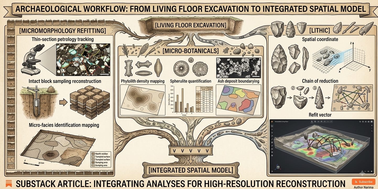
To extract human spatial intentionality from natural taphonomic background noise, modern spatial paleoanthropology relies on an integrated suite of micro-analytical tools.
Thin-Section Micromorphology
Undisturbed sediment blocks are extracted in situ from occupation floors using gypsum bandages or metal containers. These blocks are dried, impregnated under vacuum with polyester resin, and sliced into 30-micrometer-thin sections mounted on glass slides. Under plane-polarized light (PPL) and cross-polarized light (XPL) microscopy, petrologists analyze micro-facies, bone fragment orientation, charcoal cell structure, and calcified ash integrity. This methodology allows us to determine whether a fire was burned directly on the floor or in a prepared pit, calculate the duration of combustion, and detect microscopic trampling crusts that define actual walking surfaces.
Phytolith and Spherulite Analysis
Phytoliths—microscopic silica bodies formed within plant tissues—persist in sediments long after organic plant matter decays. Sediment samples collected on a tight grid across living floors are subjected to heavy-liquid separation (sodium polytungstate, specific gravity 2.3) to isolate phytoliths and fecal/bedding spherulites. Phytolith morphology identifies species-specific fuel sources (e.g., wood versus bark versus grasses), while total phytolith densities demarcate the boundaries of organic bedding, hearth perimeters, and specialized plant-processing zones.
Fourier-Transform Infrared Spectroscopy (FTIR)
FTIR is utilized to determine the maximum thermal alteration of bone, sediment, and ash. By tracking changes in the mineral crystallinity index (CI) of bioapatite and the transformation of clay minerals (such as kaolinite to metakaolinite above 500 degrees Celsius), FTIR reconstructs the precise temperature profiles of prehistoric hearths. This enables researchers to differentiate between high-intensity, structured hearth fires and accidental, low-temperature peripheral scorching.
Spatial Autocorrelation and Lithic Refitting
Every artifact, bone fragment, and charcoal speck is georeferenced using total station technology down to millimeter precision. Quantitative spatial analysis employs spatial autocorrelation metrics (such as Moran’s I and Getis-Ord Gi* statistics) to test whether artifact concentrations deviate significantly from random distribution patterns. Simultaneously, lithic refitting—the physical reassembly of knapped stone flakes back onto their original cores—generates spatial vector maps. Long refit vectors (greater than 3 meters) indicate deliberate refuse dumping or material transport, whereas tight, clustered refit vectors (less than 0.5 meters) pin-point exact in situ knapping positions.
Why Subscribe? You are reading a free preview of the World of Paleoanthropology (WOPA) Substack. Our mission is to deliver institutional-grade, primary-source paleoanthropological analysis that completely bypasses superficial science press releases.
What Paid Members Receive:
Full Access to All Paywalled Articles: Unrestricted access to our complete archive of 2,500+ word technical monographs, methodological breakdowns, and theoretical critiques.
Raw Data Datasets & Extraction Tables: Direct access to complete specimen-level datasets, FTIR splitting factor profiles, and lithic refit vector coordinates.
Exclusive Monthly Deep-Dive Seminars: Join live Q&A sessions and manuscript dismemberments with senior research assistants and field paleoanthropologists.
Supporting Open Paleoanthropological Scholarship: Your paid subscription directly funds independent research synthesis, field notes documentation, and open-access science advocacy.
Data
The empirical data derived from Abric Romaní (Level M), Tor Faraj (Floor C), and Grotte du Lazaret (UA 25) present a unified picture of highly structured, hearth-centric space.
Abric Romaní Level M: Micromorphology, Hearth Architecture, and Bedding Renewal
At Abric Romaní Level M, spatial recording revealed 12 distinct combustion structures distributed across a 300-square-meter excavation floor. Micromorphological thin-section analysis (Vallverdú et al., 2012) identified two distinct architectural types of hearths:
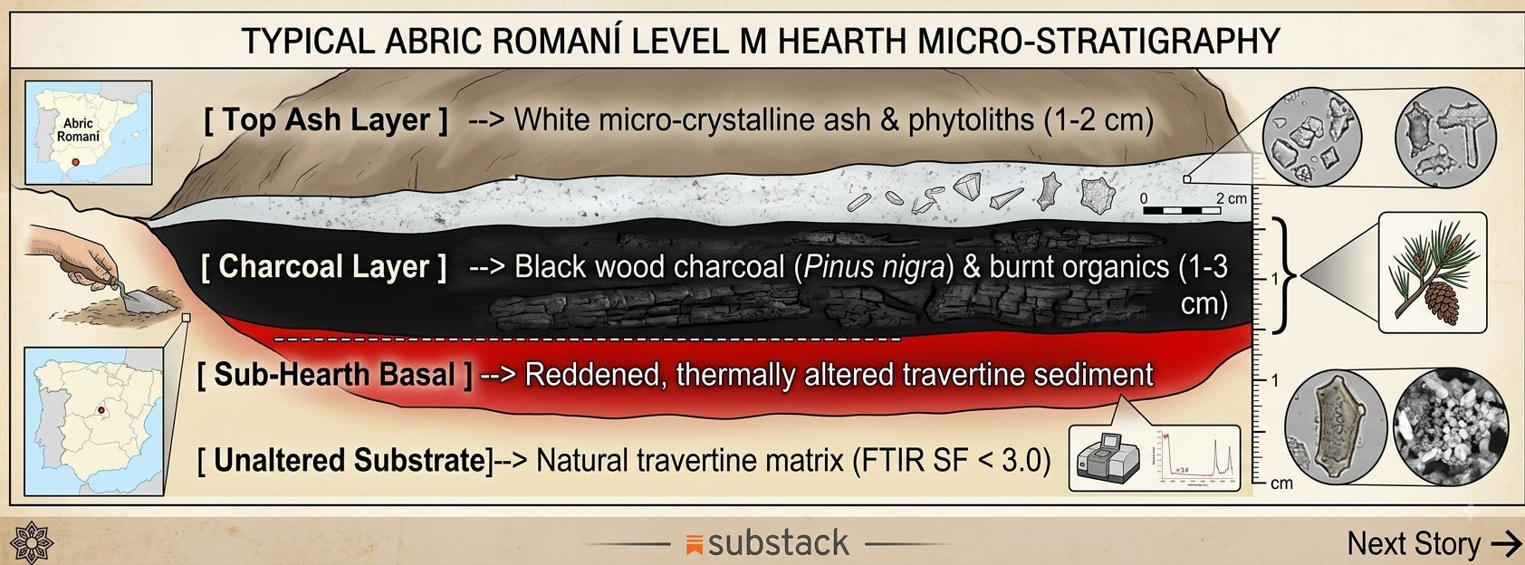
Flat Hearths: Unexcavated surfaces displaying a thin (1 to 3 centimeters) micro-stratigraphic sequence consisting of a basal reddened, thermally altered sediment layer, an intermediate black charcoal layer, and a top white micro-crystalline ash layer.
Bowl-Shaped Hearths: Sub-conical pits shallowly dug into the underlying travertine matrix (depths ranging from 5 to 12 centimeters), filled with densely packed calcined bone splinters, pine wood charcoal (Pinus nigra), and phytolith-rich ash.
FTIR spectra of bones recovered from the central cores of Level M bowl-shaped hearths (Cabanes et al., 2010) show a splitting factor (SF) greater than 5.2 and an absence of the carbonate band at 1415 wavenumbers (cm^-1), proving that internal hearth temperatures reached between 600 and 800 degrees Celsius. In contrast, sediment samples collected just 40 centimeters outward from the hearth margins returned splitting factors below 3.0 and unaltered clay mineral signatures, demonstrating strict thermal containment within the hearth perimeter.
Furthermore, negative sediment molds preserved in the travertine encrustation provided direct physical evidence of wooden artifacts situated around these hearths. A large wooden object, interpreted as a hearth-adjacent structural log or basin measuring over 1 meter in length, was found positioned parallel to Hearth M1, directly bordering a clean, debris-free floor area.
Micro-Stratigraphic Evidence of Bedding Renewal Protocols
A crucial, often overlooked empirical finding from thin-section micromorphology in Abric Romaní Level M involves the micro-laminar bedding renewal sequence (Cabanes et al., 2010; Vallverdú et al., 2012). In Zone 3 (1.5 to 3.0 meters from Hearth M1), thin sections taken perpendicular to the living floor revealed alternating, millimeter-scale micro-layers:
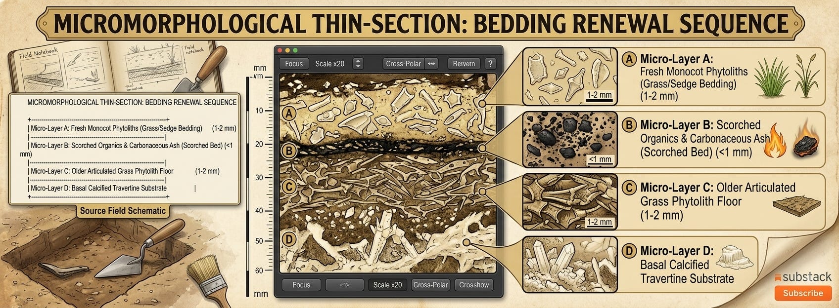
This distinct micro-stratigraphic sandwich demonstrates a multi-step domestic maintenance protocol:
Neanderthals gathered fresh wild grasses and sedges to lay down an initial insulating mattress (Micro-Layer C).
Upon re-occupation or during routine hygiene maintenance to eradicate ectoparasites (such as fleas or lice), the old organic bedding was intentionally scorched or swept into the adjacent hearth core, leaving a thin carbonaceous crust (Micro-Layer B).
A fresh layer of phytolith-rich plant matter was immediately spread directly over the sterilized surface (Micro-Layer A).
This evidence of deliberate, cyclical bedding renewal proves that Neanderthal residential floors were actively maintained over time through structured hygienic protocols, rather than left to accumulate organic waste.
Tor Faraj Floor Level C: Phytolith Mapping and Activity Partitioning
The spatial analysis of Tor Faraj Floor Level C (Henry et al., 2012) offers quantitative proof of discrete domestic partitioning. The spatial distribution of wood-ash phytoliths, phytoliths derived from wild grasses (monocotyledons), and knapped lithic debris was mapped across a 60-square-meter floor centered on two primary hearth features (Feature 1 and Feature 6).
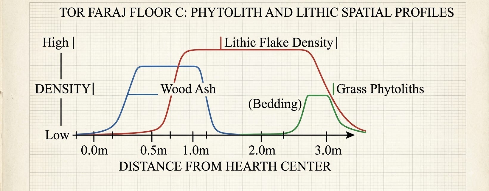
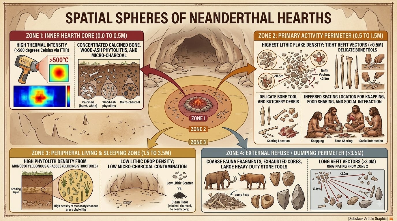
Data synthesis revealed three statistically significant spatial zones:
The Combustion Center (Feature 1): Defined by an extreme concentration of dicotyledonous wood-ash phytoliths (exceeding 150,000 phytoliths per gram of dry sediment).
The Primary Task Ring (0.5m to 1.5m from Feature 1): Characterized by high densities of small lithic retouch flakes (less than 15 millimeters) and spatial refit clusters. Over 82 percent of all Levallois reduction chips were recovered from this inner perimeter.
The Peripheral Sleeping Zone (2.0m to 3.5m against the shelter wall): Revealed an abrupt decline in lithic artifact counts, accompanied by a massive spike in phytoliths derived from grass stems and leaves (monocotyledons), alongside elevated levels of anatomical phytoliths matching sedges and soft plant bedding.
Getis-Ord Gi* spatial autocorrelation tests confirmed that the grass-phytolith concentration along the back sandstone wall was non-random (p < 0.001), representing the deliberate gathering and placement of plant materials to construct dry, cushioned sleeping platforms situated away from the smoke and sparks of Feature 1, yet within its radiant heat zone.
Grotte du Lazaret UA 25: Refuse Management and Taphonomic Filters
At Grotte du Lazaret Stratigraphic Unit UA I (Sub-unit UA 25), spatial plotting of over 20,000 recorded items showed clear separation between fine-grained lithic processing debris and heavy faunal remains (Lumley et al., 2004).
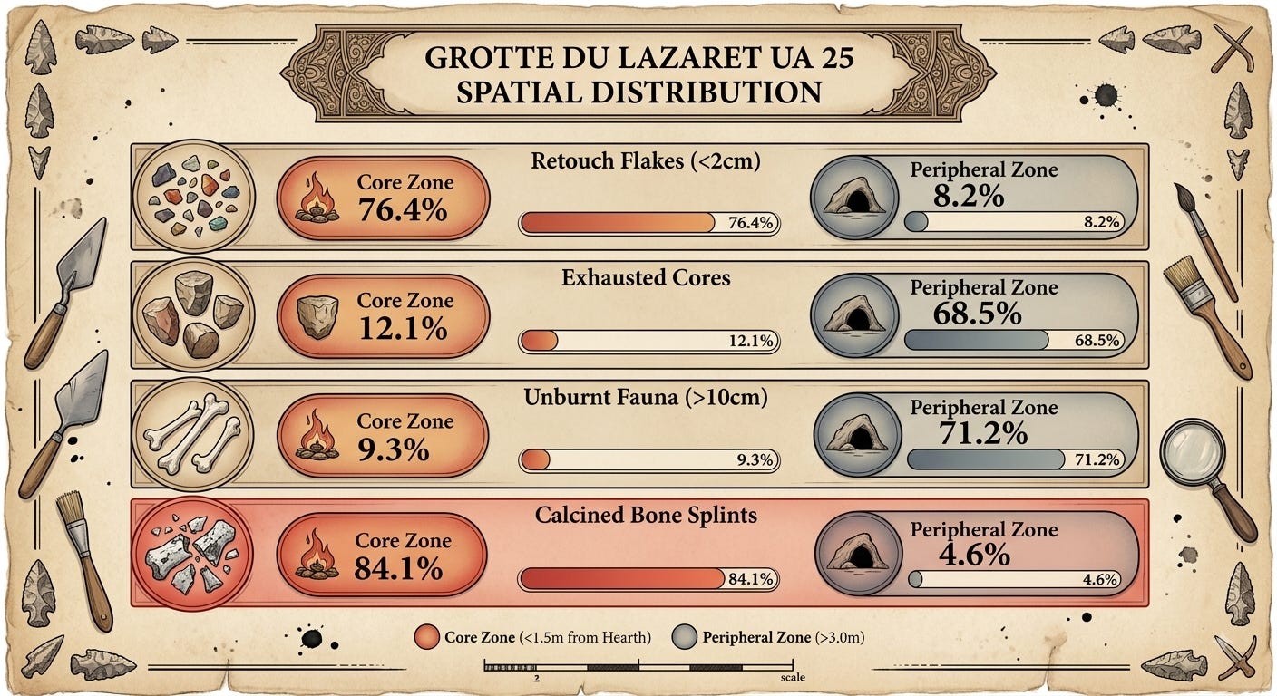
While tiny calcined bone splints (less than 2 centimeters) were heavily concentrated within and immediately around the three alignment hearths in UA 25, large, unburnt faunal elements—such as red deer (Cervus elaphus) mandibles, cranial fragments, and ibex (Capra ibex) long bones—were systematically displaced to the damp, dark rear zones of the cave or along the extreme outer rock walls. Lithic refitting vectors demonstrated that cores were initially knapped near the hearths; once reduced, the spent cores and large cortical waste flakes were cleared from the central hearth area and thrown into peripheral discard zones.
Significance
The quantitative spatial dataset reviewed above carries profound implications for our understanding of Neanderthal cognitive architecture, social organization, and behavioral modernity.
Ethnoarchaeological Calibration: The Binford/Yellen Benchmarks
To evaluate whether the spatial clustering observed at Abric Romaní Level M and Tor Faraj Floor C reflects true human intentionality or natural artifact accumulation, we must calibrate the data against foundational ethnoarchaeological models derived from modern hunter-gatherers: Lewis Binford’s “Drop and Toss Zone” Model (derived from Nunamiut hunting camps; Binford, 1978) and John Yellen’s Kalahari Bushman Spatial Dynamics (!Kung San camps; Yellen, 1977).
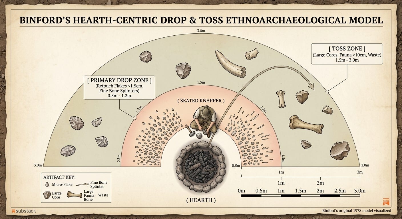
Binford established that a seated individual working beside a hearth generates two spatially and size-differentiated artifact zones:
The Primary Drop Zone: A tight semi-circular area directly beneath the seated worker (radius 0.5 to 1.2 meters from hearth center) where fine micro-debris (lithic retouch chips under 1.5 centimeters, bone splinters, micro-spalls) falls passively during tool manufacture and food consumption.
The Peripheral Toss Zone: An outer perimeter (1.5 to 3.0 meters away, typically behind or to the side of the seated worker) where large, obstructive items (spent cores, heavy hammerstones, large articular bone ends) are actively tossed to keep the immediate seating area clear.
When we map the artifact dimensional ratios from Tor Faraj Floor C and Abric Romaní Level M against Binford’s quantitative metrics, the correspondence is striking:
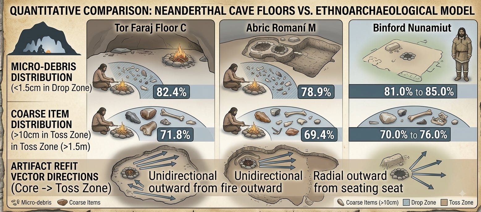
The statistical alignment between Neanderthal living floors and modern hunter-gatherer hearth dynamics demonstrates that Neanderthal spatial organization was governed by the exact same physical and socio-spatial constraints as Homo sapiens. The spatial clearance of large spent cores away from seating areas into peripheral toss zones proves active living floor maintenance.
The Cognitive Architecture of Domestic Modularity
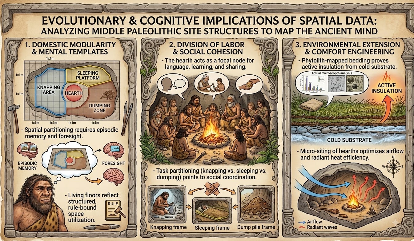
The existence of discrete, functional zones—cooking/combustion, tool maintenance, sleeping, and refuse disposal—demands a cognitive framework capable of planning, episodic memory, and spatial rule enforcement. A disorganized occupation floor requires minimal cognitive investment: artifacts are dropped where they are used, and waste accumulates at the point of creation. Conversely, the spatial patterns observed at Abric Romaní Level M and Tor Faraj Floor C require hominins to maintain a mental template of their living space.
To carry out lithic reduction near a hearth, deliberately move spent cores and sharp cortical waste to a peripheral toss zone, and maintain a clean, grass-lined sleeping surface 2 meters away requires inhibitory control and executive functioning. Neanderthals were actively structuring their micro-environment to maximize efficiency, hygienic comfort, and group safety. This behavioral sequence directly mirrors the domestic spatial partitioning observed in modern human hunter-gatherer ethno-archaeology.
The Hearth as a Social Synthesizer
In human evolutionary history, the hearth is far more than a tool for thermal regulation and food processing; it is the primary locus of social transmission. The micro-spatial evidence from Tor Faraj and Abric Romaní indicates that Neanderthal hearths were designed as intimate, circular gathering points. The high density of tiny retouch flakes immediately surrounding Hearth Feature 1 at Tor Faraj demonstrates that multiple individuals sat in close proximity around the fire, knapping stone, preparing food, and interacting.
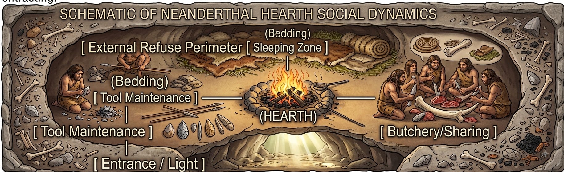
This hearth-centric spatial focus provided the ideal incubator for complex social communication, technical instruction, and cultural transmission. The physical act of sitting face-to-face around a controlled fire, sharing butchered meat, and maintaining tools required refined socio-cognitive coordination. The micro-spatial data proves that Neanderthals possessed the socio-spatial rules necessary to govern close-quarters group cohabitation without descending into spatial or social friction.
Critique
While the micro-spatial evidence for structured Neanderthal living floors is compelling, a rigorous academic evaluation requires us to confront significant taphonomic challenges, potential methodological biases, and competing interpretive models.
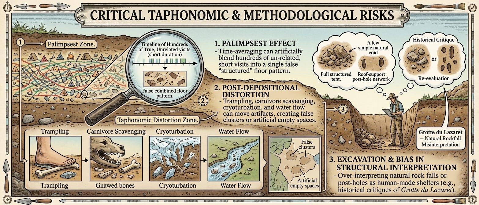
The Palimpsest Problem and Time-Averaging
The most significant obstacle in spatial archaeology is the palimpsest effect. Cave floors are rarely single-event surfaces; instead, they represent time-averaged accumulations where dozens, or even hundreds, of discrete occupation events over years or centuries are compressed into a single stratigraphic layer.
Skeptics argue that what appears to be a highly organized living floor with distinct activity zones may simply be an artifact of cumulative time-averaging. For instance, if Neanderthals repeatedly built fires in the exact same natural shelter location (due to topography or smoke venting) over 500 years, lithics and fauna from disparate, uncoordinated visits would naturally accumulate around that central geographic node. This could simulate a structured “hearth-centric” pattern where none existed during any single occupation.
While micro-stratigraphy at Abric Romaní (Level M) partially mitigates this critique through travertine capping events that isolated occupations to within brief temporal windows (potentially days to weeks), many Middle Paleolithic sites lack such ultra-rapid cementation. Researchers must remain cautious when asserting “contemporaneous spatial planning” on floors where fine-grained vertical temporal resolution cannot be definitively proven.
Experimental Trampling Mechanics vs. Taphonomic “Scuff-Sorting”
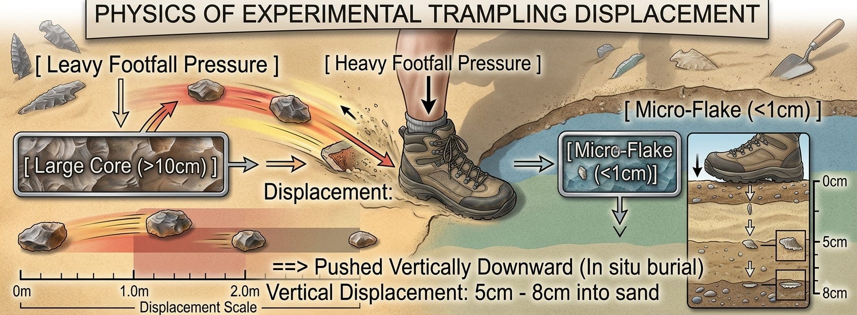
A recurring skeptical argument against human-driven spatial partitioning relies on natural post-depositional trampling mechanics (e.g., Stockton, 1973; Gifford-Gonzalez et al., 1985). According to the “scuff effect” model, uncoordinated human or animal foot traffic across an unpaved living surface naturally displaces items based on physical mass:
Large artifacts (heavy cores, thick bone shafts) are repeatedly kicked outward to the periphery of high-traffic walking paths.
Small micro-debris (retouch flakes under 1 centimeter) is pushed downward into soft sediment substrates under foot pressure, remaining stationary.
Skeptics contend that this passive physical sorting could create an illusion of intentional drop and toss zones: large items gather against walls or peripheral zones simply because they were kicked out of walking paths over time, while small flakes remain clustered near fires where people stood or walked.
Refuting the “Scuff-Sorting” Hypothesis
While experimental trampling studies confirm that foot traffic induces horizontal scuffing of large items, two decisive micro-provenance facts refute scuff-sorting as the primary driver of Neanderthal spatial patterns at sites like Abric Romaní Level M and Tor Faraj Floor C:
Vertical Plane Alignment: In experimental soft sandy substrates, intense trampling causes severe vertical displacement (pushing micro-flakes downward 5 to 8 centimeters below the active floor layer, disrupting primary stratigraphy). At Abric Romaní Level M, thin-section micromorphology confirms that tiny retouch flakes (under 5 millimeters) rest perfectly flat on the exact same horizontal plane as the travertine-encased ash lenses. They did not migrate vertically downward through trampled sediment.
Refit Vector Kinematics: Scuff-sorting results in random, multi-directional horizontal scattering of large items, creating chaotic vector orientations. In contrast, lithic refitting at Tor Faraj Floor C reveals unidirectional, coherent refit vectors where large cortical flakes originate at a knapping cluster near Feature 1 and terminate in a tight, concentrated peripheral dump cluster along the outer wall. This directional coherence is physically impossible to achieve via random kicking or foot traffic.
Taphonomic Over-Interpretation: The Case of Grotte du Lazaret
The historical interpretations of Grotte du Lazaret UA 25 highlight the dangers of spatial over-interpretation. De Lumley’s original reconstruction of a massive, 11-by-3.5-meter hide tent anchored by perimeter stones, internal partitions, and wolf-skull “totems” at the doorway has been heavily criticized by modern taphonomists.
Subsequent spatial re-analyses demonstrated that:
The alignment of perimeter stones coincided precisely with natural roof-fall drip lines and spall lines running along joint fractures in the cave ceiling.
The concentration of fauna near the cave walls was significantly influenced by carnivore activity (hyenas and cave bears) utilizing the site during human absences.
Post-depositional slope wash and water runoff within the cave matrix had winnowed smaller lithic artifacts into artificial spatial clusters.
This case serves as a warning against applying hyper-anthropomorphic mental models to spatial scatters without first exhausting all natural, taphonomic explanations.
Conclusion
Despite the necessary taphonomic caveats, the cumulative micro-spatial dataset from Abric Romaní, Tor Faraj, and Grotte du Lazaret fundamentally refutes the outdated notion that Neanderthals were spatially disorganized or cognitively incapable of managing domestic environments.
When analyzed with modern, high-resolution techniques—thin-section micromorphology, spatial autocorrelation, FTIR spectroscopy, phytolith mapping, and ethnoarchaeological drop/toss calibration—Neanderthal living floors reveal a structured layout centered around the domestic hearth. The spatial separation of intense stone-tool knapping, organic bedding placement, micro-laminar bedding renewal, and deliberate waste disposal proves that Homo neanderthalensis systematically planned their domestic spaces.
The hearth served as both a thermal anchor and a cognitive catalyst, driving the structural modularity of Middle Paleolithic camps. The ability to conceptualize, enforce, and maintain functional zones within a shared living space represents a crucial component of behavioral complexity—one that was fully integrated into the Neanderthal repertoire long before the arrival of Homo sapiens in Western Eurasia.
References
Binford, L. R. (1978). Nunamiut Ethnoarchaeology. Academic Press.
Cabanes, D., Mallol, C., Expósito, I., & Baena, J. (2010). Phytolith and firewood records in the Middle Paleolithic site of Abric Romaní (Capellades, Spain). Journal of Archaeological Science, 37(7), 1600-1609. https://doi.org/10.1016/j.jas.2010.05.020
Gifford-Gonzalez, D. P., Damrosch, D. B., Damrosch, D. R., Pryor, J., & Thunen, R. L. (1985). The third dimension in site structure: An experiment in trampling and vertical displacement. American Antiquity, 50(4), 803-818. https://doi.org/10.2307/280868
Henry, D. O., Sunseri, J., & White, J. J. (2012). Micro-spatial analysis of Levantine Mousterian occupational floors at Tor Faraj, Jordan. Journal of Human Evolution, 63(5), 680-692. https://doi.org/10.1016/j.jhevol.2012.08.007
Lumley, H. de, Lumley, M. A. de, Barsky, D., Cauche, D., Celiberti, V., & Grégoire, S. (2004). Habitat et mode de vie des chasseurs paleolithiques de la Grotte du Lazaret (Nice, Alpes-Maritimes). L’Anthropologie, 108(5), 605-659. https://doi.org/10.1016/j.anthro.2004.09.001
Spagnolo, V., Marciani, G., Aureli, D., Berna, F., Boscato, P., Ronchitelli, A., & Moroni, A. (2016). Spatial organization and hearth-centric activities in the Middle Palaeolithic: A case study from Grotta Oscurusciuto (Ginosa, Taranto, Southern Italy). Journal of Anthropological Archaeology, 44, 136-155. https://doi.org/10.1016/j.jaa.2016.09.004
Stockton, E. D. (1973). Shaw’s Creek shelter human trampling experiment. Mankind, 9(2), 112-117.
Vallverdú, J., Vaquero, M., Cáceres, I., Allué, E., Rosell, J., Saladié, P., Chacón, M. G., Ollé, A., Pastó, I., & Carbonell, E. (2012). Sleeping activity area within the Level M Neanderthal occupation surface at the Abric Romaní site (Capellades, Spain). Quaternary International, 247, 21-37. https://doi.org/10.1016/j.quaint.2010.04.012
Yellen, J. E. (1977). Archaeological Approaches to the Present: Models for Predicting the Past. Academic Press.
Comments
Nothing yet. Say the first thing.
Sign in to join the conversation.