
Heads up! It is increasingly likely that, starting this fall, the world will experience one of nature’s more disruptive phenomena. Based on previous experience, it will have serious implications for regions of the US, and for other parts of the globe. Preparing now could avoid some of its more costly impacts.
The underlying process is the El Niño Southern Oscillation or ENSO, a cycle in the tropical Pacific that involves regular reversals in trade winds and ocean heat distribution. Its phase when warmer water is brought to the South American coast was named El Niño (the Christ child) because this tends to happen around Christmas.
If you are not familiar with ENSO, the UK Met Office has prepared a useful 4-1/2 minute explanatory video.
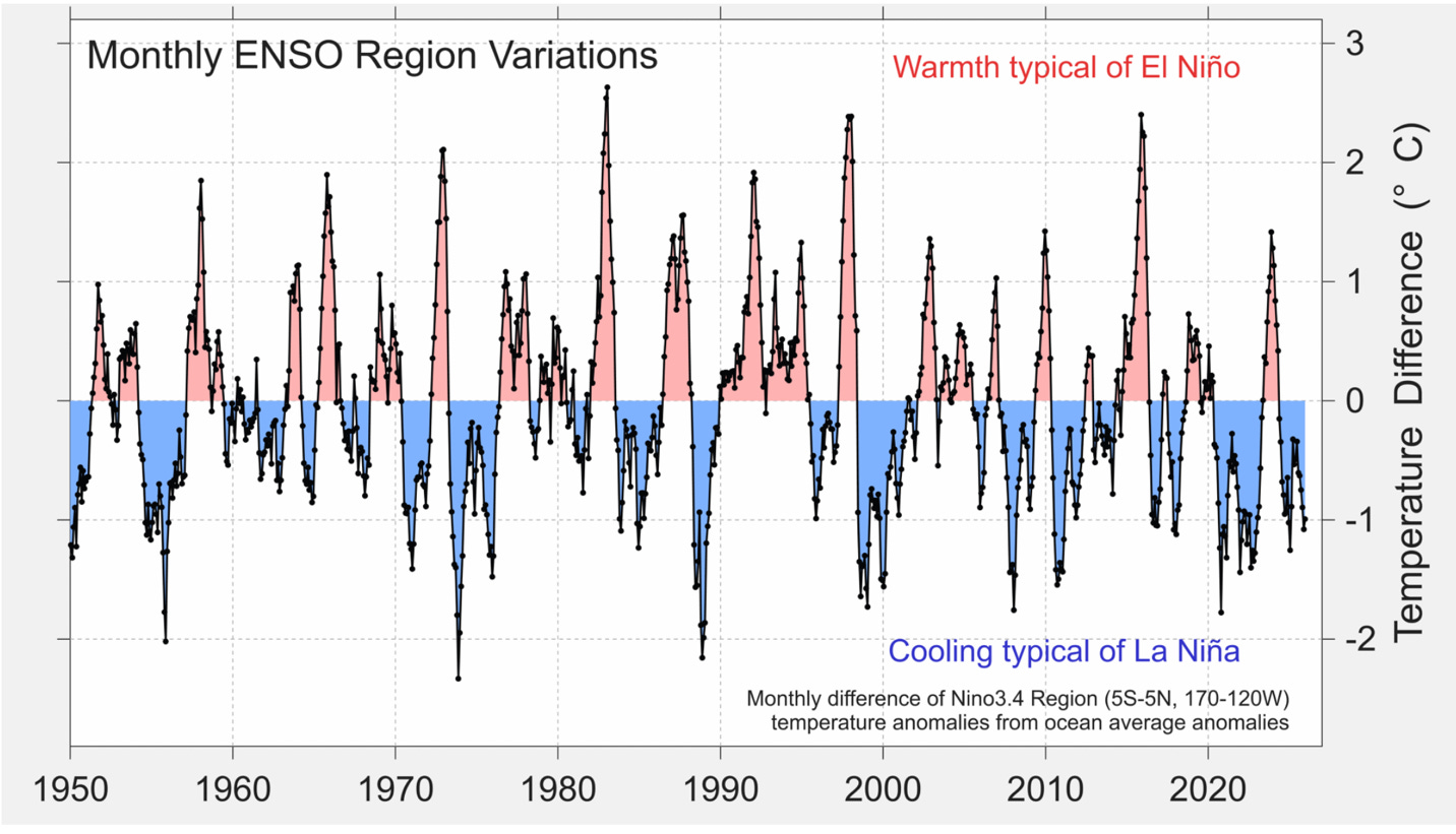
The Pacific goes into its El Niño phase approximately every 2 to7 years, as can be seen in this figure from the March 2026 Temperature Update from Berkeley Earth.
These oceanic and atmospheric cycles alter weather around the globe. The details differ from event to event, but one common pattern is increased rainfall and flooding in some regions and drought and increased fire risk elsewhere (as suggested by the puffy clouds in the Met Office video). Also, during these events the surface of the Pacific is warmer, feeding heat into the lower atmosphere and raising its temperature.
A commonly used measure of the strength of an El Niño is the increase in ocean temperature in a region of the central Pacific (called El Niño-3.4). It is the one used in the figure. Warming in this region between 1.5°C and 2.0°C is generally classified as a “strong” El Niño, and a rise over 2.0°C is a “very strong” one.
The NOAA Climate Prediction Center (part of the National Weather Service) prepares forecasts of these events. A build-up of heat in the subsurface ocean and a weakening of the trade winds are leading indicators that an El Niño is coming. Month to month the latest measurements of these changes, plus other ocean and atmospheric conditions, are fed into Atmosphere–Ocean General Circulation Models to forecast its strength.
This next figure shows NOAA’s estimate as of June. In August through January it is certain that ENSO will be in its El Niño phase. In November-December-January (NDJ) when NOAA estimates a 88% chance the El Niño will be strong (over 1.5°C) and a 63% chance that it will not be just strong but very strong (over 2.0°C).
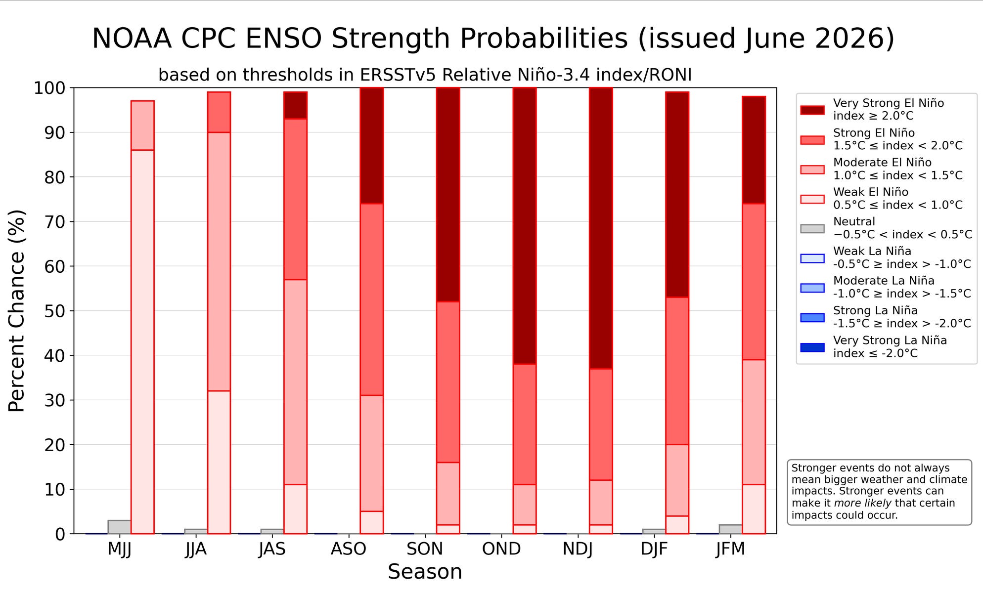
More concerning, NOAA’s forecast is relatively conservative compared to estimates by other groups in the US and around the world. The average of ENSO forecasts by 13 of these efforts shows an 80% chance of a very strong El Niño in NDJ 2026. The average estimate of the peak rise in Niño-3.4 temperature is around 3°C.
Next fall, therefore, there is a disturbingly high likelihood of worldwide disruption. In the US. for example, experience shows that a strong El Niño portends extreme rainfall and flooding in California and other parts of the Southwest. But the biggest economic and social impact will be drought in South and Southeast Asia, and perhaps in Australia and southern Africa.
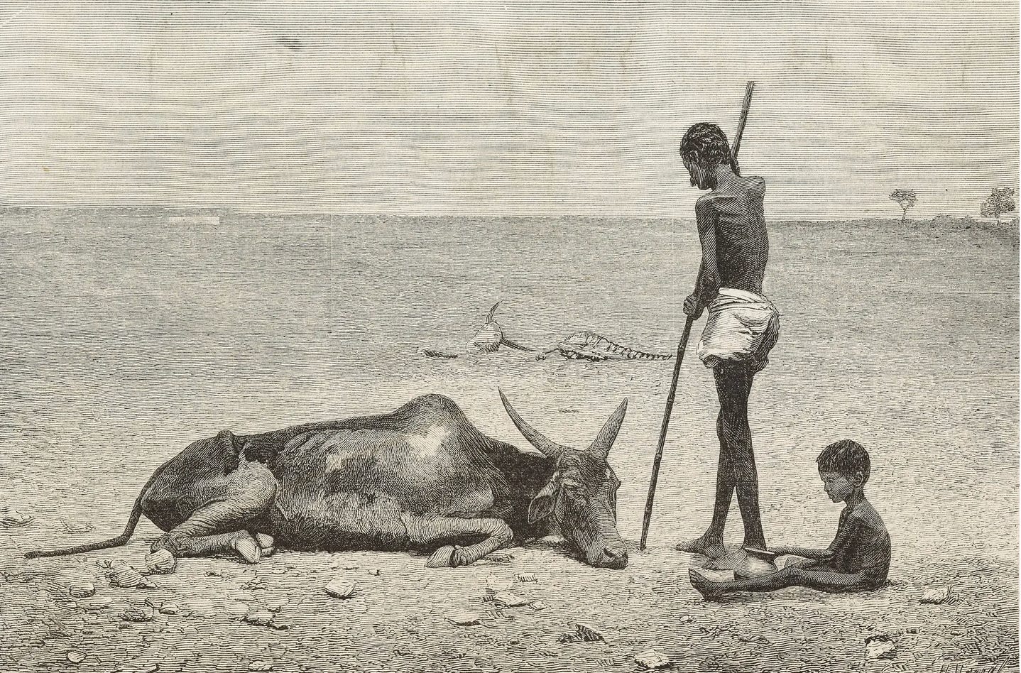
To convey how damaging a strong El Niño can be for these regions, studies often refer to The El Niño of 1877-78 in which millions died. (It is the origin of the picture at the top of the article.) The conditions leading to that disaster will not likely be repeated. Global food systems have improved over the last 150 years because of expanded global trade, national food stocks, and development of international aid agencies.
Nevertheless, experience of the strong El Niños of 1982-83, 1997-98 and 2023-24 (easily seen in the first figure above) shows that the resulting water scarcity can still create food insecurity and other disruption in many countries. Moreover, compared to previous decades, two other conditions combine to produce poorer agricultural output under an El Niño now. Rising global temperatures diminish crop yields in some regions. And the closing of the Strait of Hormuz has cut off a key source of fertilizer and raised the price of diesel fuel. Even when the Strait is opened, it will take months for these markets to return to normal. In the meantime, farmers will be left either without, or priced out of, needed inputs.
As of early June, the strength of the growing El Niño is yet uncertain, but the risk is very great. Just sitting and watch it happen is foolish, and there are areas of preparation the US and other nations should be about.
First is to document the experience to inform responses to future events like this. For example, a scientific experiment was carried out during the 1997-98 El Niño that produced vital insights into how drought-driven diarrheal diseases in some Pacific Island countries could be successfully managed with education and capacity building. Also, the study revealed ways that flooding risks could be mitigated through proactive planning, attention to supply chains, and protection of health care facilities. The upcoming El Niño is an opportunity to augment this work by monitoring the changing risks during and after the event, and evaluating the effectiveness of interventions to protect human and natural systems.
Where extreme rainfall is the main risk, efforts should start now to increase resilience to the coming risks of flooding. An example is the effort of some US cities to warn institutions and individuals about what is coming and provide guidance about how to prepare.
Preparing for a potential food crisis in Asia and other regions is more challenging. Organizations like the World Food Program have early warning systems to alert populations at risk, and it and other UN agencies are attempting preparatory action. Unfortunately, these organizations are already strained by ongoing international and civil conflicts, climate shocks, economic slumps, disease outbreaks and other disasters.
Worse, the Trump Administration (with some other nations following) has drastically reduced national support for food assistance and other international aid programs. The Famine Early Warning Systems Network (FEWS NET), run by the US Agency for International Development (AID), was a leading organization monitoring food insecurity worldwide for more than 40 years. It was gutted along with the rest of the Agency in the early months of the new administration. The US contribution to food aid, also earlier an AID function, was shifted to the Agriculture Department with a reduced budget—plus an “America First” provision requiring that any US contribution come from domestic commodities.
News of widespread hunger could lead to a reversal of some of these cuts and perhaps to an emergency program of food aid. But timing will be crucial: mounting such an effort could take weeks to months. If a very strong El Niño continues to develop as forecast, signs of coming famine will appear in spiking future prices of staple commodities like wheat, rice, palm oil and sugar. If the nations that could help are not now preparing to respond to these signals, any response will likely come too late.
______________________
Henry Jacoby is William F. Pounds Professor of Management (emeritus), M.I.T.
Kristie Ebi is a principal in ClimAdapt, LLC.
Gary Yohe is the receiving agent of Gary W. Yohe, LLC and Huffington Foundation Professor of Economics and Environmental Studies (emeritus), Wesleyan University.
Richard Richels lead author for multiple chapters of IPCC studies in areas of mitigation, impacts and adaptation.
No posts
Comments
Nothing yet. Say the first thing.
Sign in to join the conversation.