
Happy weekend! I want to start off my newsletter this morning with a quick follow up to my post several days ago about the NWS national IT/comms failure during a severe weather event. I shared in the post excerpts from the NWS directive on declaring “critical weather days” during which any changes and upgrades to IT/comms systems are halted.
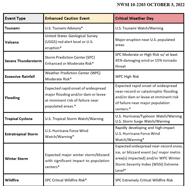
A Balanced Weather reader shared with me yesterday that there is actually a more recent NWS Directive on this topic that I missed in my research for my post. This directive more clearly outlines specific criteria based on NWS national outlooks for various hazardous weather threats — which as an aside is another demonstration of the importance of those outlooks. Based on these criteria, the enhanced SPC severe weather outlook and moderate WPC excessive rainfall outlook on this day would not have justified a critical weather day declaration, but rather an “enhanced caution event.” Per the directive, this is defined as:
Some significant weather or events may warrant more targeted caution, allowing most NOAA/NWS enterprise Information Technology (IT) operational changes and service upgrades to proceed, while taking steps to ensure availability of critical operational services and applications that are the most crucial to protecting life and property.
My interpretation of this is that an “enhanced caution event” would mean that NWS staff responsible for major IT upgrades on that day would be alerted of the potential for impactful weather events, and monitoring would be occurring for weather developments that might necessitate postponing changes to some critical systems if high impact weather was ongoing. Again, as I pointed out in the my original posts, I know that these sorts of decisions are very complicated with a lot of factors having to be considered — which is why it is important that critical agencies like NWS be adequately resourced and have leadership at all levels that supports a strong organization with a solid culture and open communication.
In preparation for a trip to the Florida Space Coast, I just finished reading an excellent book about the history of the Kennedy Space Center. I was struck by the clear parallels between NOAA and NASA and their challenges with balancing both research and operational responsibilities. The authors detailed the three major operational loss of life failures that NASA has suffered — Apollo 1, Challenger, and Columbia — and in none of these events was any one person or decision responsible. They were all the result of a chain of failures and problems that resulted from serious organizational challenges.
Due to a variety of their own organizational challenges — some caused by recent events but others much more long term and chronic — I and many colleagues I talk to are concerned that NOAA/NWS are in a place where operational failures have become more of a concern. I hope that agency officials are looking at episodes like the IT/comms failure last week to try to learn and help ensure that the organization can be strengthened to reduce the likelihood of future events.
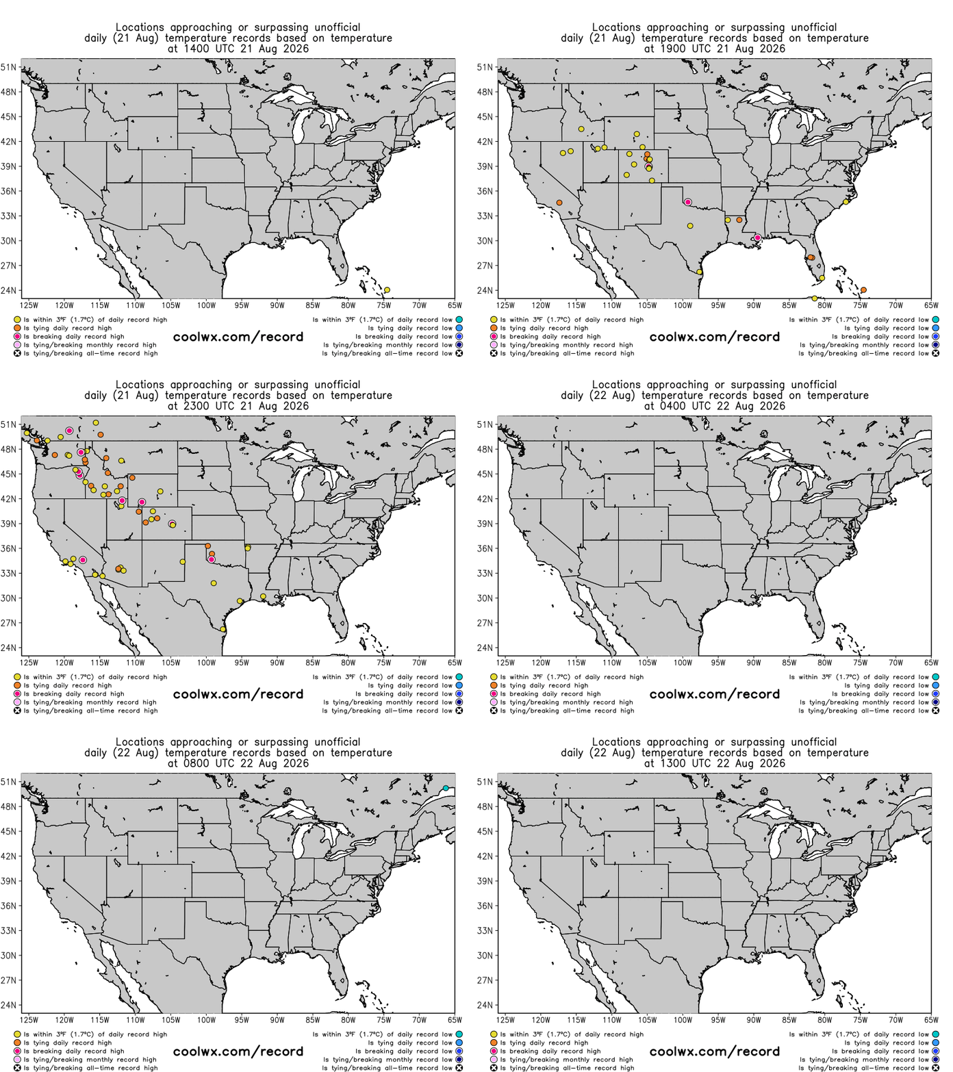
The heat continues to be the major story in US weather, with numerous record highs set on Friday from the Southern Plains to the Pacific Northwest.
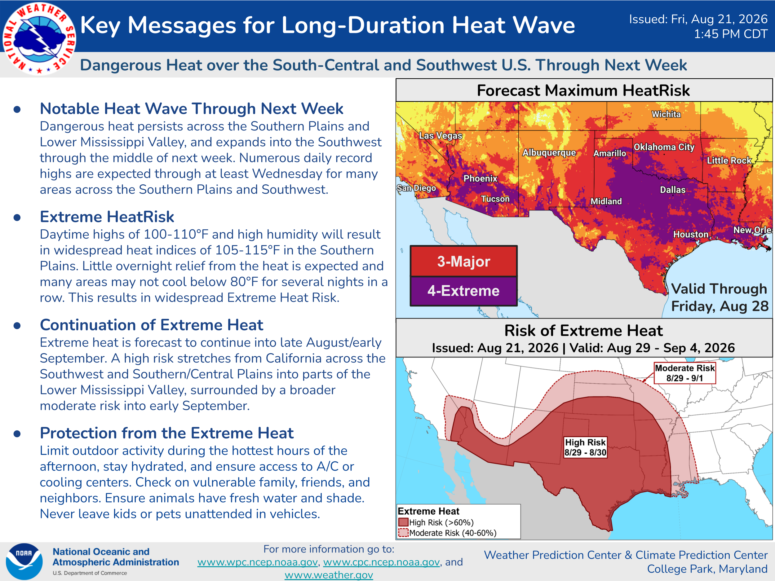
The southwest and south-central US will continue to deal with serious heat and periodic record warm temperatures for the foreseeable future as an upper level dome of high pressure remains locked over the region for at least the next 7-10 days.
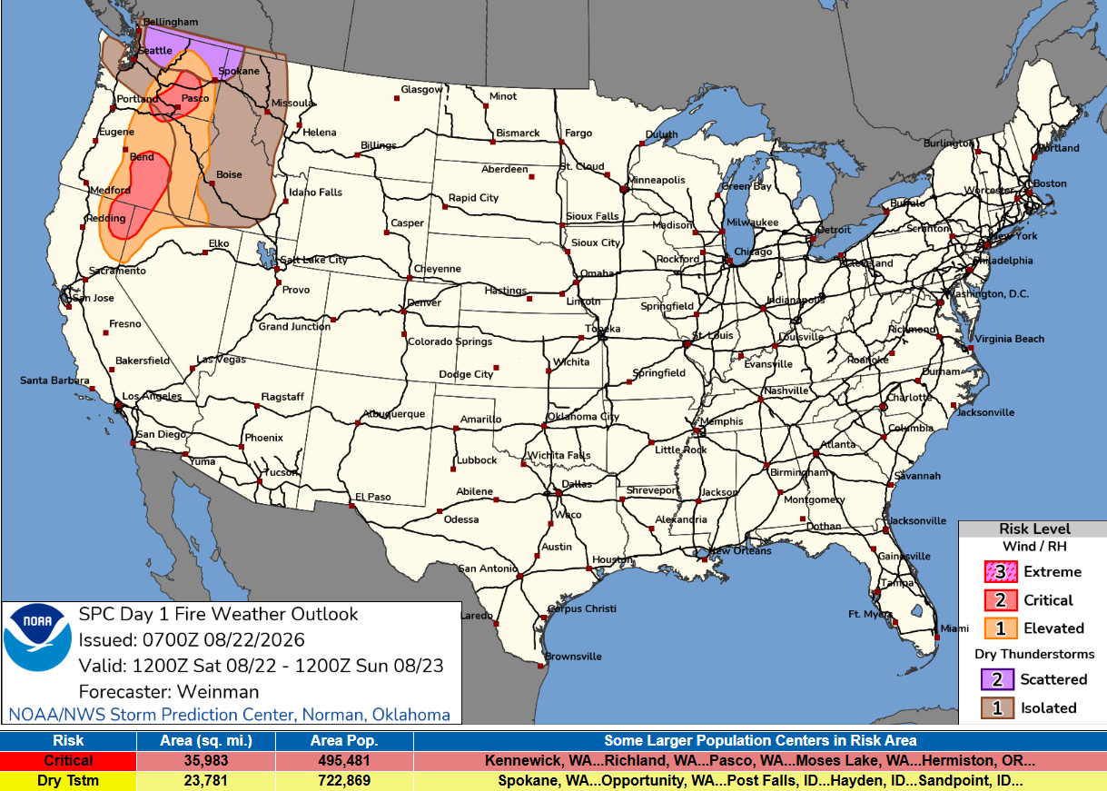
After a somewhat more favorable weather period in which progress was able to made on many wildfires in the West, critical fire danger will return today, with a combination of windy, dry weather and isolated to scattered dry thunderstorms yielding the potential for wildfire issues today.
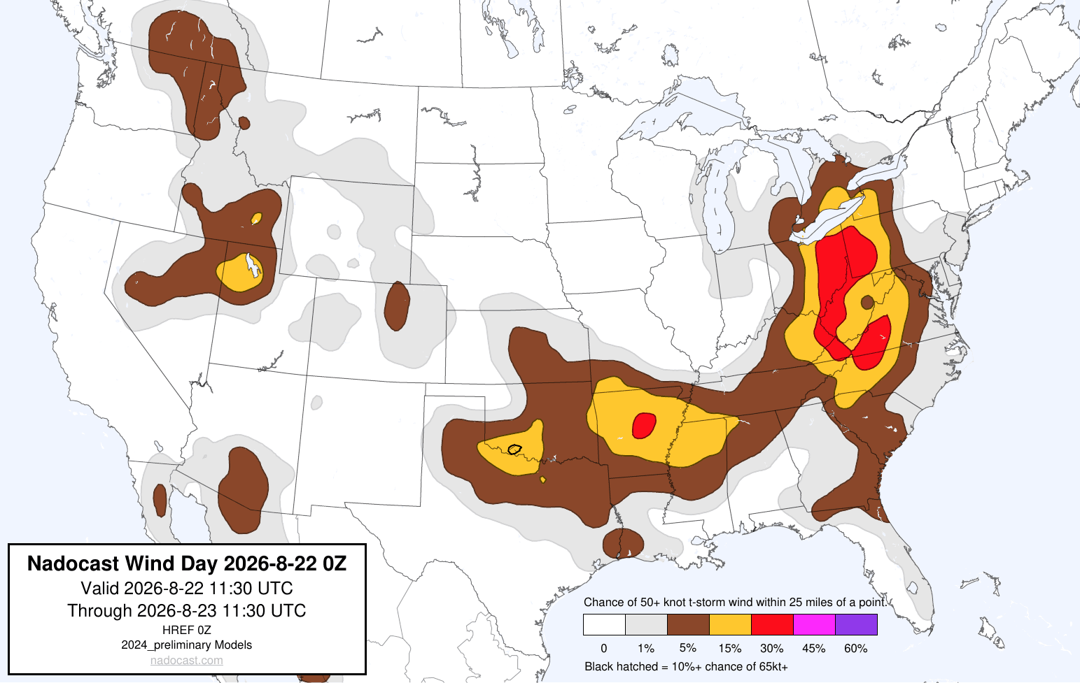
Severe weather will remain a concern over parts of the Ohio Valley and Appalachians today as a disturbance moving through upper level trough of low pressure over the East produces thunderstorms with potential for strong winds. Another disturbance moving through the southwest part of this trough will feed off the heat and humidity across the south central US to produce some strong to severe storms over parts of the Mid-South, while a few severe storms will be possible in the West from monsoonal moisture on the west side of the upper high.
![[Key Messages]](https://substackcdn.com/image/fetch/$s_!zMri!,f_auto,q_auto:good,fl_progressive:steep/https%3A%2F%2Fsubstack-post-media.s3.amazonaws.com%2Fpublic%2Fimages%2Fa3528b4f-f8a0-478b-af66-88a19578009d_897x736.png "[Key Messages]")
The tropical depression southeast of Hawaii strengthened into Tropical Storm Moke yesterday, and this morning it is moving west-northwest with maximum sustained winds of 45 mph. While the intensity forecast for Moke has come down some, the overall forecast scenario has not changed much for Hawaii as shown above.
Programming note: we are going to be busy with some fun stuff the next couple of days, so I am going to take some time off. If something really crazy happens weatherwise I may do a quick post or two — otherwise, I will be back sometime Tuesday. Hope everyone has a great weekend!
Balanced Weather is made possible by the generous support of paid subscribers, who as thanks get access to live Balanced Weather chats and videos as well as the ability to post comments and ask questions on posts. To become a paid subscriber or a free subscriber (also very much appreciated and you will automatically receive new posts in your email), please click below.
No posts
Comments
Nothing yet. Say the first thing.
Sign in to join the conversation.