
In the years following the Battle of Culloden, British forces imposed a brutal crackdown across the Highlands and Scotland. As primary evidence unearthed and transcribed by the Stennis Historical Society and freely available at Military Cantonments of the British Army in Scotland, 1745-56 have shown the British Army, usually with its Scottish Regiments sent abroad to fight and die, garrisoned Scotland from top to bottom, border to firth and beyond, in a full scale military occupation.
The Jacobite cause had been defeated militarily, but the war on memory was just beginning. Symbols were targeted. culture was suppressed. The kilt was banned. The aim was not merely to punish rebellion — but to extinguish the cultural and political identity that had sustained it.
One of the most remarkable acts of defiance from this period came not from the battlefield, the street or the pulpit, but from a copperplate. It came in the form of a map. A map quietly engraved, but charged with grief, and embedded with protest.
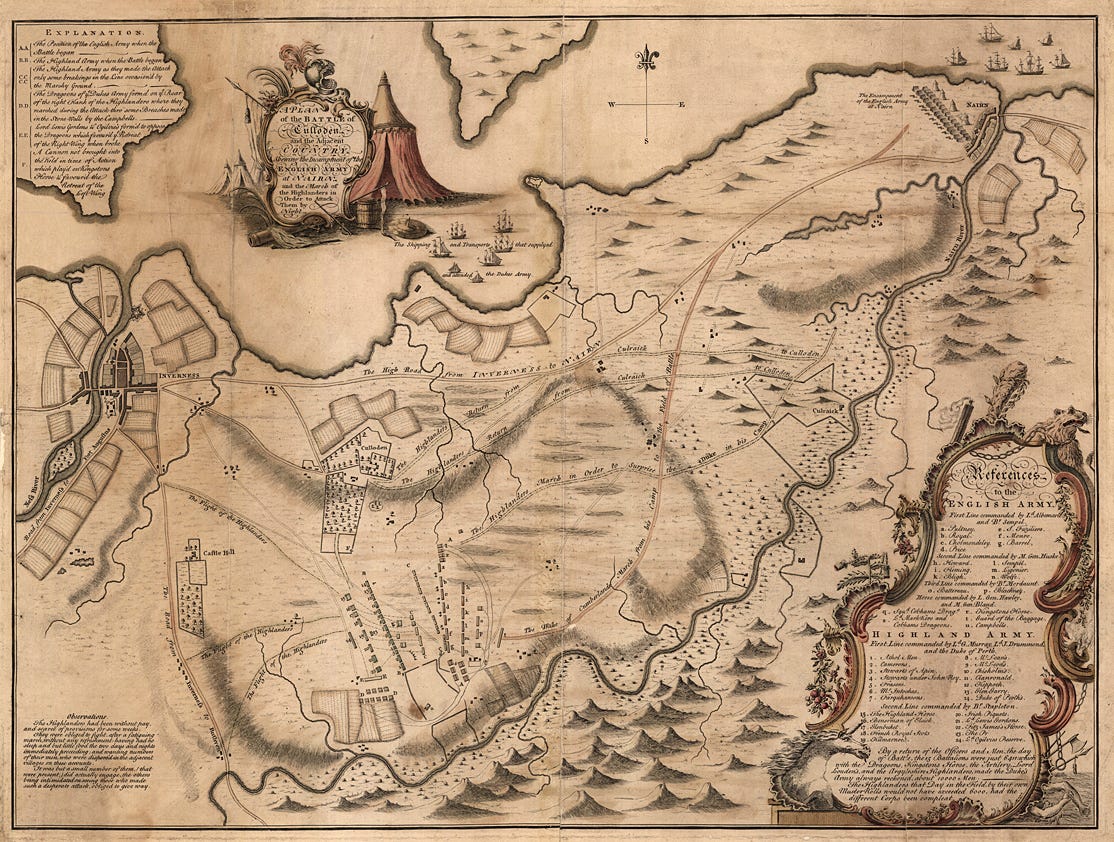
This is the story of John Finlayson, Jacobite artillery officer turned cartographer, and the map he created that tried to tell the truth about what Scotland had lost.
John Finlayson fought at Culloden in April 1746:
“Finlayson, a 'mathematical instrument-maker' at Edinburgh, acted as commander of the Jacobite artillery at Culloden after Colonel James Grant (who would also produce maps of the Jacobite campaign himself) had been struck by a ball at the siege of Fort William in March.”
T. Pollard (Ed.), Culloden. The history and archaeology of the last clan battle, Barnsley, 2009. p.
After the defeat, unlike many of his comrades who were executed or forced into exile, Finlayson eventually returned to Edinburgh.
“Finlayson appears to have been captured immediately after the battle, as a 24-year-old 'John Findlason, Engineer, Artillery, [of] Edinburgh' is listed in 'A Return of the Rebel Officers and soldiers now Prisoners in Inverness, 19th April 1746' in the Cumberland Papers at Windsor Castle. He was trans- ported on board the Jane of Alloway to Tilbury Fort but was released and back at home by August 1747.”
T. Pollard (Ed.), Culloden. The history and archaeology of the last clan battle, Barnsley, 2009. p.
Once home he resumed work as an engraver.
This choice might seemed like retreat from active opposition to the British regime. It was not. Instead of taking up arms again, he picked up engraving tools. And he used them to record, and encode, the trauma of national defeat.
Around 1750, Finlayson published a map titled A Plan of the Battle of Culloden. At first glance, it appears to be simply a military and topographical map, depicting troop positions and terrain. But to a careful eye, it reveals far more. Embedded within the map’s border are a series of symbols that transform the work from cartography into elegy.
Finlayson's map is unique not just for its detail, but for the rich symbolic frame he engraved around the written details. This border is often mistaken for decorative flourish, but it is nothing of the sort. Every image is a metaphor for what Scotland had endured:
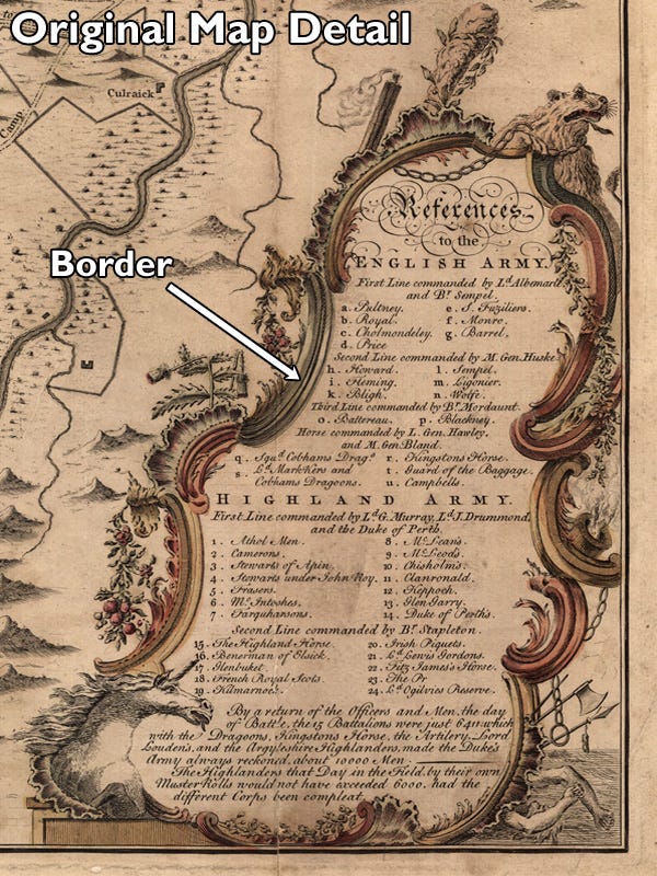
The Chained Lion: Traditionally a symbol of Scottish courage and sovereignty, the lion appears shackled and with its mane shorn. This isnʼt merely a defeated beast — it is humiliated, bound and mutilated.
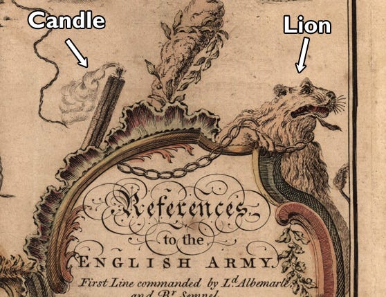
The Snuffed Candle: Often associated with life, knowledge, or divine light, the extinguished candle possibly symbolises the end of a political tradition, a line of kings, even a way of life. It certainly symbolises an end of hope.
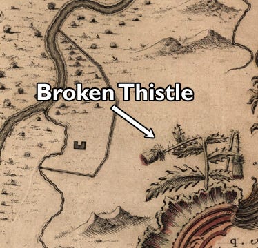
The Broken Thistle: The thistle, long a symbol of Scotland, appears snapped and crushed. It represents not just military defeat, but the trampling of national identity.
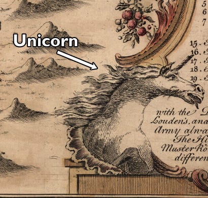
The Shattered Unicorn: The unicorn, Scotland’s national animal and a heraldic emblem of untamed spirit, is shown with its horn broken. Its power has been destroyed; a clear allegory for the end of independent sovereignty.
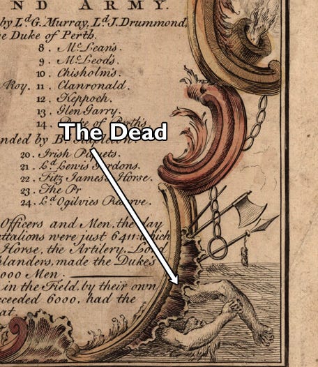
The Dead at the Border: Perhaps most poignantly, arms of the slain are shown reaching or sprawling across the geographical boundary between England and Scotland — a visual reminder that the consequences of defeat were not just political, but mortal.
These images werenʼt included for aesthetic balance. They were acts of resistance, encoded into the very language of print. In an age when direct political protest was met with imprisonment and sometimes death, symbolism became the last refuge of truth.
The British authorities recognised the significance of Finlayson's map. It wasnʼt a neutral document. It challenged the legitimacy of the post-Culloden settlement and implicitly accused the state of injustice and erasure. For this, Finlayson was arrested. His engraving plates were seized and destroyed. Only a few prints of the map survived, smuggled out or hidden by sympathisers.
The reaction speaks volumes. This wasn’t the suppression of a mere map — it was the silencing of a witness.
That the British state felt threatened by a map says much about its content, but even more about the climate of repression in which it was created. The goal wasn’t simply to defeat Jacobitism as a political force, but to annihilate its memory. Finlayson’s work defied that.
Finlayson’s map does more than document a battle. It memorialises a lost sovereignty. It wasn’t created in the heat of conflict but in its cold aftermath, when the smoke had cleared and the consequences had begun to settle in. Its message is simple but devastating: something sacred has been broken, and no official map, no Act of Parliament, no royal proclamation can make it whole again.
That message directly undermines the central myth of post-Union Britain: that the Union was final, that Scotland had been peacefully integrated, and that resistance was a backward relic of feudalism. Finlayson knew otherwise. He had lived through a brief return of sovereignty in 1745–46. He had seen the Union declared null. He had served a functioning alternative government. He had watched it fall.
His map remembers what the official histories tried to forget.
Today, Finlayson’s map survives only in rare reproductions and academic references. Most Scots have never seen it. Fewer still have been taught to read it. And yet it stands as one of the most powerful visual documents of Scotland’s colonial condition.
It doesn’t shout or argue.
It mourns.
And in doing so, it preserves the truth: that Scotland was free, and then it was broken.
We still live with the consequences. But Finlayson ensured that we wouldnʼt live without memory.
Original surviving copies of Finlayson's map are held in private and institutional collections. Scans are publicly available via various historical archives:
A plan of the battle of Culloden and the adjacent country, shewing the Incampment of the English Army at Nairn and the March of the Highlanders in order to attack them by night National Library of Scotland (Retrieved 14 Aug 2025).
Military Maps: JOHN FINLAYSON (ACTIVE 1746-1753) Plan of the Battle of Culloden, 1746 (Retrieved 14 Aug 2025).
T. Pollard (Ed.), Culloden. The history and archaeology of the last clan battle, Barnsley, 2009.
For more on the legal framing of Scotland’s sovereignty in 1745–46, see Scotland Was Free: The Forgotten Months of Jacobite Sovereignty, Angry Pict, Substack, 6 August 2025.
This article continues from:
Scotland Was Free: The Forgotten Months of Jacobite Sovereignty.
If you’d like to support my research into Scotland’s true history, you can chip in for running costs (and the coffees that keep me going) here: https://ko-fi.com/angrypict
No posts
Comments
Nothing yet. Say the first thing.
Sign in to join the conversation.