
Welcome to new readers of the American Geographical Society’s weekly, the AGS Globe! The Globe shares articles on geography and geospatial, along with exciting opportunities and news from our network. Our pieces fall under four categories: Exploring the World, Championing Geography, Mapping the News, and EthicalGEO. As the world revolves, geography evolves. The mission of the AGS Globe is to bring our storied legacy of exploration and thought leadership into the frontiers of the future.

By Betty Huang
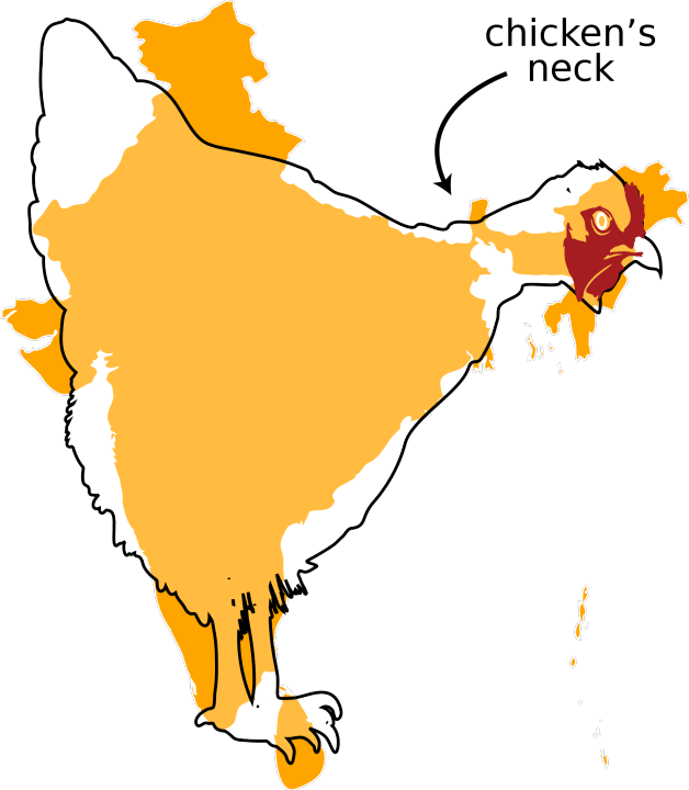
In northeastern India lies a sliver of land just 13 miles (~21 km) wide at its narrowest point, connecting mainland India to its eight northeastern states: Arunachal Pradesh, Assam, Manipur, Meghalaya, Mizoram, Nagaland, Sikkim, and Tripura. If it were ever cut off, more than 40 million people would be isolated from the rest of their country and the daily goods they depend on.
The Strait of Hormuz, the Malacca Strait, and the Suez Canal are all examples of chokepoints. These are places where the flow of people, goods, and military power gets funneled into a single passage. Whoever controls the terrain controls everything that depends on it. The Siliguri Corridor is one of these areas, bordered by Nepal to the west, Bhutan to the north, Bangladesh to the south, and China to the northeast. It sits at the intersection of four international borders within roughly 62 miles (100 kilometers).
Before 1947, British India was one continuous landmass. Upon independence, Bengal was divided and the eastern portion became East Pakistan, later Bangladesh. This cut off eight states of India–Assam, Nagaland, Manipur, Meghalaya, Tripura, Mizoram, and Arunachal Pradesh Sikkim– referred to regionally as “the Northeast”, leaving them connected to the rest of the country only by the narrow strip of West Bengal.
This corridor serves 40 to 50 million people, carrying major highways, trunk railways, oil and gas pipelines, and broadband infrastructure The two national highways running through the corridor, NH 17 and NH 27, carry the bulk of goods moving between mainland India and the northeast. A broad-gauge railway line carries passengers, freight, and petroleum supplies. The national power grid runs through it, and so do oil and gas pipelines. Roughly 95 percent of exports from the northeastern states pass through this single strip of land.
China is the corridor’s primary threat. A southward advance from the Chumbi Valley would place Chinese forces on the Jampheri Ridge, giving them a direct line of sight over the entire corridor below. China’s growing diplomatic influence in Nepal and Bangladesh adds further pressure. In response, India has heavily militarized the corridor, including stationing Rafale jets at Hasimara, deploying S-400 air defense systems and BrahMos missiles, and building three new army bases in 2025 at Bamuni, Kishanganj, and Chopra.
Beyond security, the corridor is the economic backbone of Northeast India, carrying goods, energy supplies, and trade to/from Nepal, Bhutan, and Bangladesh. Over the last several years, India has been trying to reduce its dependence on this single passage through a series of regional connectivity projects: the BBIN Motor Vehicle Agreement, the India-Myanmar-Thailand Trilateral Highway, and the Kaladan Multimodal Project. None of these projects have been fully delivered. The BBIN agreement stalled when Bhutan’s parliament declined to ratify it. The Kaladan corridor through Myanmar has been held up by ongoing conflict there. For now, the corridor remains the only bridge between mainland India and its northeast.
Further complicating matters, for most of the past decade, India’s relationship with Bangladesh was stable. Sheikh Hasina, who led the country until August 2024, kept close ties with India. When her government fell, her replacement, Muhammad Yunus, took a harder approach. During a visit to Beijing in early 2025, Yunus described India’s northeastern states as “landlocked” and positioned Bangladesh as a gatekeeper. In 2025, Yunus gifted Pakistan’s top military official a book whose cover featured a map appearing to show India’s northeastern states as part of Bangladesh. This incident deepened tensions between Bangladesh and India.
Facing threat, India has been closely watching a proposed airbase at Lalmonirhat in northern Bangladesh, reportedly being built with the assistance of China, just 84 miles (135 kilometers) from the corridor. While these changes do not mean conflict is imminent, India's southern flank has shifted quickly, with a less friendly neighbor, growing Chinese involvement nearby, and new infrastructure going up close to the corridor.
BorderLens. (2024, October 17). The strategic lifeline: Securing the Siliguri Corridor amid escalating Chinese expansion. https://www.borderlens.com/2024/10/17/the-strategic-lifeline-securing-the-siliguri-corridor-amid-escalating-chinese-expansion/
Barman, S. (2026). The Siliguri Corridor in geostrategic perspective: Security imperatives and the politics of connectivity in South Asia. The Asian Quarterly, 2(1), 116–125.
eGrow Foundation. (n.d.). The Siliguri Corridor. https://egrowfoundation.org/blog/the-siliguri-corridor/
Geopolitical Monitor. (2025, December 12). Siliguri Corridor: The Achilles’ heel of India. https://www.geopoliticalmonitor.com/siliguri-corridor-the-achilles-heel-of-india/
India Today. (2025, December 13). Siliguri Corridor: A more muscular Chicken’s Neck. https://www.indiatoday.in/magazine/defence/story/20251222-siliguri-corridor-a-more-muscular-chickens-neck-2834912-2025-12-13
Indica Info. (n.d.). Why Northeast India depends on the Siliguri Corridor. https://indicinfo.in/why-northeast-india-depends-on-the-siliguri-corridor/
New Indian Express. (2025, May 25). Why Chicken’s Neck is a perennial security challenge.https://www.newindianexpress.com/explainers/2025/May/25/why-chickens-neck-is-a-perennial-security-challenge-3
Thanks for reading The AGS Globe! This post is public, so feel free to share it.
Did you enjoy reading this? Support the American Geographical Society today with a donation of $50 to help us support Geography education.

Members of the American Geographical Society enjoy reduced-price access to AGS events and free access to the online version of Geographical Review.


Attention APHG Teachers - Join AGS in New York City this November as a Geography 2050 Teacher Fellow! In addition to regular symposium sessions, our fellows participate in two days of specialized workshops where they can connect with other educators, get access to new classroom tools, and learn about college and career pathways for their students. Applications are open until June 14th and can be found on the Geography Educator Initiative page of our website.
This year’s Geography 2050 venue and themes have been announced! Save the date for our annual fall symposium, Geography 2050: Africa Shaping Tomorrow, taking place this November 19-20, 2026, at the Schomburg Center for Research in Black Culture in New York City! By 2100, over one-third of the world’s population will live in Africa, already the world’s youngest and fastest-growing continent, with profound implications for the interconnected human and environmental facets of the transformative demographic and technological boom across Africa. You can view this year’s Geography2050 website here.
Comments
Nothing yet. Say the first thing.
Sign in to join the conversation.