
Welcome to new readers of the American Geographical Society’s weekly, the AGS Globe! The Globe shares articles on geography and geospatial, along with exciting opportunities and news from our network. Our pieces fall under four categories: Exploring the World, Championing Geography, Mapping the News, and EthicalGEO. As the world revolves, geography evolves. The mission of the AGS Globe is to bring our storied legacy of exploration and thought leadership into the frontiers of the future.

Read the piece by Dorothy Janick on our EthicalGEO Blog here.
In September 2024, Hurricane Helene made landfall in Florida and caused catastrophic flooding far beyond the coastline. While coastal areas experienced storm surge and flooding, the storm’s most destructive impacts occurred inland as intense rainfall spread north and west into the Appalachian region. Across Appalachia, rivers overflowed, small creeks turned into fast-moving torrents, and homes were swept from their foundations. More than 200 people died, thousands of homes were damaged or destroyed, and some towns were nearly wiped out by the flooding.
The disaster shocked many residents in inland communities such as Asheville. Asheville had long been described as a “climate haven,” or a place expected to be safer from climate-related disasters. FEMA’s flood maps, which are the main flood-risk reference used in the United States, suggested that only about 2 percent of properties in western North Carolina faced significant flood danger. As a result, many residents did not realize how vulnerable they actually were.
This was not an isolated event. During Hurricane Sandy in 2012, more than half of the homes damaged in New York City were located outside FEMA’s designated flood-hazard zones. Similar disasters have occurred across the country, from Dallas to Barre, where severe flooding struck areas not officially considered high-risk. According to FEMA, about 40 percent of flood insurance claims between 2017 and 2019 came from properties outside mapped flood-hazard zones or from places FEMA had not yet mapped.
These events reveal major problems with how flood risk is calculated and communicated. FEMA’s flood maps are largely based on historical data and define “Special Flood Hazard Areas” as places with a 1 percent annual chance of flooding. While this method worked better in the past, climate change is rapidly altering weather patterns, increasing heavy rainfall, and raising sea levels. This makes future flooding much harder to predict using older data alone.
There are also technical limits to flood mapping. FEMA’s maps mainly focus on river flooding and coastal flooding because those hazards are tied to visible geographic features like rivers and shorelines. People who live far from water often assume they are safe. However, FEMA maps usually do not show flash-flood risk. Flash floods can develop within hours during intense rainfall and can happen almost anywhere, even in places far from rivers or coasts. They are especially dangerous because they are fast-moving and difficult to predict.
Flood disasters are often made worse when multiple types of flooding happen at the same time. During Hurricane Helene, a storm surge nearly 15 feet high hit Florida’s Big Bend region while heavy rain caused additional flooding inland. As the storm moved into the mountains of Appalachia, the terrain intensified river flooding throughout the region. Experts describe these overlapping disasters as “compound flood events,” where different hazards interact and amplify one another, making the destruction even more severe.
Flood maps themselves simplify a very complex reality. No single map can fully capture every possible flood risk, especially as climate conditions continue to change. Experts argue that flood-risk communication needs to become more flexible and transparent about uncertainty.
Another major issue is how FEMA’s maps are used. Although many people now rely on them to understand flood danger, the maps were originally designed mainly to support infrastructure rules and the National Flood Insurance Program. Buildings located within FEMA flood zones must follow flood-protection standards, such as elevating equipment or using flood-resistant materials. However, these regulations are based on current flood risk, not future conditions. A building constructed today in a “safe” area could face much greater flood danger decades from now as climate change worsens.
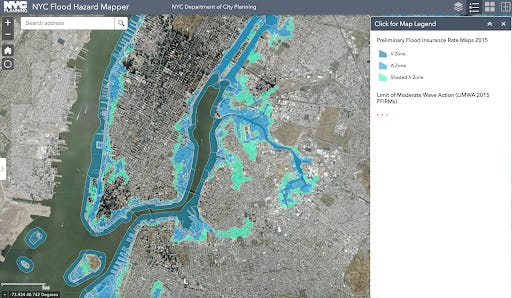
Flood maps also directly affect insurance costs. Homeowners in FEMA flood zones are often required to purchase flood insurance if they have federally backed mortgages. Because updated flood maps can increase insurance rates and construction costs, local governments and developers sometimes resist expanding flood-hazard zones. In 2015, when FEMA proposed expanding New York City’s floodplain by 80 percent, the city challenged the proposal and worked with FEMA to revise the maps.
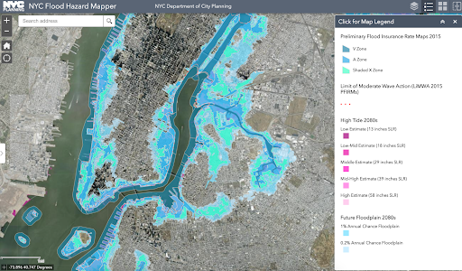
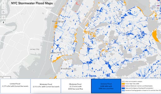
Some cities are now creating additional flood tools to address these shortcomings. New York City, for example, has developed maps that show future climate-related flooding and stormwater flooding in addition to FEMA’s insurance maps. These tools help residents better understand long-term risks to their neighborhoods.
Flooding also exposes deep social and economic inequalities. Lower-income households are less likely to have flood insurance, savings, or resources to recover after disasters. Studies have shown that FEMA mitigation funding has often been distributed unevenly, with wealthier and majority-white communities receiving more support because their property values are higher. Research in North Carolina also found that towns with larger non-white populations were less likely to receive flood insurance benefits than wealthier white communities in the same counties.
Experts argue that better flood maps alone will not solve these problems. Even the most accurate forecasts cannot protect vulnerable communities if resources, insurance access, and disaster aid remain unequal. As climate change increases the frequency and intensity of flooding, many researchers believe communities will need not only better maps, but also stronger planning, fairer policies, and more direct action to protect people before disasters occur.
Crowe, K. et al. (2024, October 13). Federal flood maps underestimated risk in areas hit hardest by Hurricane Helene. Washington Post. https://www.washingtonpost.com/weather/2024/10/13/fema-flood-maps-hurricane-helene/.
Flavelle, C. et al. (2020, June 29). New data reveals hidden flood risk across America. New York Times. https://www.nytimes.com/interactive/2020/06/29/climate/hidden-flood-risk-maps.html.
Hassan, A. and Taft, I. (2024, October 6). What we know about Hurricane Helene’s destruction so far. New York Times. https://www.nytimes.com/2024/09/29/us/helene-destruction-florida-north-carolina.html
Kruczkiewicz, A. et al. (2023). Are underserved populations left out of national flood mitigation efforts and facing greater impact? A method to assess racial inequality at the census tract level. Journal of Climate Resilience & Climate Justice, 1, 78–92. https://doi.org/10.1162/crcj_a_00005
Landau, M.D. (2024, October 11). Many Americans are buying homes in flood zones—and don’t realize it. National Geographic. https://www.nationalgeographic.com/science/article/flood-maps-fema-risk-insurance
McGee, K. (2021). A place worth protecting: Rethinking cost-benefit analysis under FEMA’s flood-mitigation programs. University of Chicago Law Review, 88.8. https://lawreview.uchicago.edu/print-archive/place-worth-protecting-rethinking-cost-benefit-analysis-under-femas-flood-mitigation
NYC Hazard Mitigation Plan (n.d.). New York City Emergency Management. https://nychazardmitigation.com/documentation/hazard-profiles/flooding/
Oakford, S. et al. (2024, December 6). America underwater: Extreme floods expose the flaws in FEMA’s risk maps. Washington Post. https://www.washingtonpost.com/climate-environment/interactive/2022/fema-flood-risk-maps-failures/.
Rook, T. (2023, August 8). FEMA maps said they weren’t in a flood zone. Then came the rain. Grist. https://grist.org/extreme-weather/federal-maps-said-they-werent-in-a-flood-zone-then-came-the-rain/.
Shaw, A. et al. (2013, December 6). Federal flood maps left New York unprepared for Sandy — and FEMA knew it. ProPublica. https://www.propublica.org/article/federal-flood-maps-left-new-york-unprepared-for-sandy-and-fema-knew-it.
Slowey, K. (2015, December 10). Flooded with controversy: Developers, owners challenge new FEMA floodplain maps. Construction Dive. https://www.constructiondive.com/news/flooded-with-controversy-developers-owners-challenge-new-fema-floodplain/410537/
Tempus, A. (2020, November 19). Presto chango: How flood map revisions allow building in risky areas. Investigative Reporting Workshop. https://archive.investigativereportingworkshop.org/news/presto-chango-how-flood-map-revisions-allow-building-in-risky-areas/.
Thanks for reading The AGS Globe! This post is public, so feel free to share it.
Did you enjoy reading this? Support the American Geographical Society today with a donation of $50 to help us support Geography education.

Members of the American Geographical Society enjoy reduced-price access to AGS events and free access to the online version of Geographical Review.


Attention APHG Teachers - Join AGS in New York City this November as a Geography 2050 Teacher Fellow! In addition to regular symposium sessions, our fellows participate in two days of specialized workshops where they can connect with other educators, get access to new classroom tools, and learn about college and career pathways for their students. Applications are open until June 14th and can be found on the Geography Educator Initiative page of our website.
This year’s Geography 2050 venue and themes have been announced! Save the date for our annual fall symposium, Geography 2050: Africa Shaping Tomorrow, taking place this November 19-20, 2026, at the Schomburg Center for Research in Black Culture in New York City! By 2100, over one-third of the world’s population will live in Africa, already the world’s youngest and fastest-growing continent, with profound implications for the interconnected human and environmental facets of the transformative demographic and technological boom across Africa. You can view this year’s Geography2050 website here.
Comments
Nothing yet. Say the first thing.
Sign in to join the conversation.