
Welcome to new readers of the American Geographical Society’s weekly, the AGS Globe! The Globe shares articles on geography and geospatial, along with exciting opportunities and news from our network. Our pieces fall under four categories: Exploring the World, Championing Geography, Mapping the News, and EthicalGEO. As the world revolves, geography evolves. The mission of the AGS Globe is to bring our storied legacy of exploration and thought leadership into the frontiers of the future.

By Joel Pomeroy
Most of the world’s great cities share a common trait: water. One recent study found that, among 513 cities with populations exceeding one million, 53% sit within 100 km (60 mi) of a coastline, accounting for 59% of the global urban population. Access to freshwater is even more fundamental; another study estimated that approximately 90% of the world’s population lives within 10 km of a freshwater body.
Yet one major city appears to defy both trends. With a metropolitan population of more than six million people, Johannesburg is located far from any coastline, major river, or lake. Rather, the city is situated within the Highveld, South Africa’s vast inland plateau of grasslands and rolling terrain. How did this sprawling metropolis develop in such a peculiar location? Part of the answer may lie in a meteor impact over 2 billion years ago.
An Ancient Origin
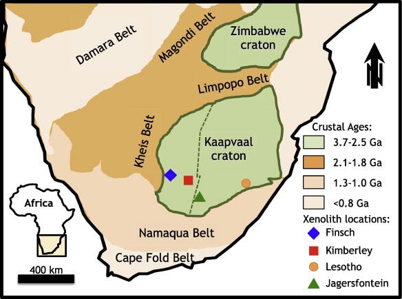
Around 2.8 billion years ago, Earth looked very different from today. Plate tectonics, the process that today builds mountains and forms continents, was just beginning. This mechanism began welding large masses of rock (cratons) into the first proto-continents. In what is now South Africa, broad muddy floodplains and shallow ponds collected layers of mud, sand, and small amounts of metals.
These calm waters were home to communities of microbes that lived in dense mats on the sediment surface. As they carried out their everyday life processes, they changed the chemistry of the water and mud around them. This created the right conditions for a mineral called pyrite, often known as “fool’s gold,” to grow. As the pyrite crystals formed, they trapped tiny particles of sediment and gold within their layers. Over time, these gold-bearing pyrite grains were buried and cemented together into conglomerate rocks.
The Asteroid Makes Impact
Around 2.02 billion years ago, an asteroid approximately 10–15 km in diameter—longer than 150 football fields—hurtled toward Earth at an estimated speed of about 15 km per second (roughly 54,000 km/h or 33,500 mph). More recent studies suggest the impactor may have been even larger and/or traveling faster than these early estimates. The asteroid struck what is now the Vredefort region of South Africa, creating the Vredefort impact structure, the largest known impact crater remnant on Earth. The immense energy released by the collision exceeded that of the asteroid impact linked to the extinction of the dinosaurs and likely caused widespread environmental disruption, with possible consequences for early life on the planet.
While the initial impact created a bowl-shaped crater, the ancient basement rock beneath it soon rebounded, pushing the surrounding rocks downward into a broad ring-shaped depression. The enormous energy released by the collision also fractured the rocky crust, creating pathways for hot, mineral-rich fluids to circulate underground. According to recent hypotheses, this impact-driven hydrothermal system was most geochemically active around the edges of the goldfields, roughly 90–100 km (~60 mi) from the center of the crater. There, temperatures were ideal for dissolving, transporting, and redepositing gold, concentrating it into reefs, thin, laterally continuous layers of gold-bearing rock.
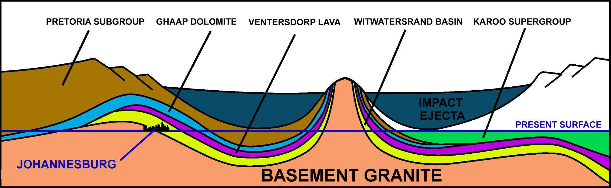
Over the next two billion years, erosion removed most of the original crater, leaving only subtle traces of the impact at the surface. It has been proposed that the impact helped preserve the gold reefs of the Witwatersrand Basin by pushing some of them deeper into the crust, where they were protected from erosion. At the same time, deformation around the crater uplifted and tilted other portions of the gold-bearing layers, bringing them closer to the surface. As erosion continued, these reefs became exposed and accessible, making them easier to discover and mine.
A Fortuitous Discovery
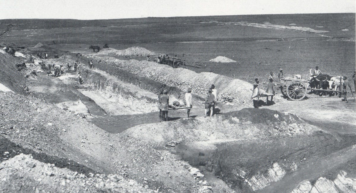
In 1886, that process ultimately paid off. Prospector George Walker discovered exposed gold-bearing conglomerates in the Witwatersrand, triggering a gold rush as prospectors, entrepreneurs, and investors flocked to the region in search of wealth. While much of the gold was “low-grade,” relatively poorly concentrated, the timing of the discovery was fortuitous. Gold was in high demand in global markets, and recent innovations had made mining low-grade reefs profitable. As thousands of miners journeyed to Witwatersrand, camps were set up to house them.
The Growth of a City
As the camps grew, they developed more infrastructure–transportation, plumbing, government–eventually transforming into small municipalities. Located directly parallel to the main gold reef emerged the largest of these places, the city of Johannesburg. The boom drew people from across rural South Africa, including both European-descended settlers and indigenous Black Africans, in search of employment and economic opportunity.
As the city grew, however, development was highly unequal. Much of the wealth generated by the colonial mining industry was concentrated in the hands of powerful businessmen known as “Randlords,” who built vast mining enterprises that relied on large numbers of poorly paid workers. The mines themselves operated under a rigid racial hierarchy: Black Africans mostly performed the manual labor, while white supervisors and skilled workers occupied higher-paying positions. Housing was segregated too, with many black laborers forced to live outside the city limits, a pattern that the apartheid (“separateness”) system would later formalize and intensify.
Nonetheless, the city continued to grow, remaining heavily tied to the gold industry during the early 20th century and coexisting with apartheid. Then, in 1939, South Africa entered the Second World War under the influence of the British Commonwealth. The fighting forced a diversification of the economy towards manufacturing, which would continue in the decades that followed. Thus, even as mines gradually began to close, Johannesburg remained the industrial capital of South Africa, a position it still holds today.
Perhaps Johannesburg should not exist. For a city of six million and the economic engine of a nation, the Witwatersrand offers neither a major river nor an obvious water source. Yet the geological legacy of a two-billion-year-old impact made that disadvantage irrelevant. Where gold was exposed, people followed, and a metropolis grew where geography suggested none should.
Agangi, A., A. Hofmann, C. Rollion-Bard, J. Marin-Carbonne, B. Cavalazzi, R. Large, and S. Meffre. 2015. Gold accumulation in the Archaean Witwatersrand Basin, South Africa — evidence from concentrically laminated pyrite. Earth-Science Reviews 140:27–53. https://doi.org/10.1016/j.earscirev.2014.10.009.
Allen, N. H., M. Nakajima, K. Wünnemann, S. Helhoski, and D. Trail. 2022. A revision of the formation conditions of the Vredefort Crater. Journal of Geophysical Research: Planets 127 (8): e2022JE007186. https://doi.org/10.1029/2022JE007186.
Gibson, R. L., and W. U. Reimold. 2026. Impact structures and deposits of South Africa. South African Journal of Geology 129 (1): 265–300. https://doi.org/10.25131/sajg.129.2746.
Hansen, K. 2018. Vredefort Crater. NASA Earth Observatory, September 1. Accessed June 4, 2026. https://science.nasa.gov/earth/earth-observatory/vredefort-crater-92689/.
Kummu, M., H. de Moel, P. J. Ward, and O. Varis. 2011. How close do we live to water? A global analysis of population distance to freshwater bodies. PLoS ONE 6 (6): e20578. https://doi.org/10.1371/journal.pone.0020578.
Macrotrends. 2026. Johannesburg, South Africa metro area population (1950–2026). Accessed June 4, 2026. https://www.macrotrends.net/global-metrics/cities/22486/johannesburg/population.
Marchi, S., A. Alexander, A. Trowbridge, and C. Koeberl. 2024. Impact-generated permeability and hydrothermal circulation at the Vredefort Impact Structure, South Africa. Earth and Space Science 11 (1): e2024EA003065. https://doi.org/10.1029/2023EA003065.
Mathieu, L., D. Mole, Z. Tóth, K. Rubingh, R. Haugaard, S. White, C. Ma, B. Frieman, R. Lodge, R. Sherlock, and B. Lafrance. 2023. The Neoarchean, a turning point for geodynamic and magmatic processes within the Superior Craton? In Laurentia: Turning points in the evolution of a continent, ed. S. J. Whitmeyer, M. L. Williams, D. A. Kellett, and B. Tikoff, Special Paper 220. Boulder, CO: Geological Society of America. https://doi.org/10.1130/2022.1220(03).
Notteboom, T., A. Pallis, and J.-P. Rodrigue. 2026. Port economics, management, and policy. 2nd ed. London: Routledge. https://doi.org/10.4324/9781003585367.
Patel, K. 2023. Ancient craters teach us Earth’s history, but scientists can’t find them. Washington Post, August 9. Accessed June 4, 2026. https://www.washingtonpost.com/climate-environment/2023/08/09/earth-impact-craters-vanishing-erosion/.
South African History Online. 2011a. Johannesburg, the segregated city. Accessed June 4, 2026. https://sahistory.org.za/article/johannesburg-segregated-city.
South African History Online. 2011b. Second World War and its impact, 1939–1948. Accessed June 4, 2026. https://sahistory.org.za/article/second-world-war-and-its-impact-1939-1948.
Unknown author. 1886. Ferreira’s Gold Mine in 1886. Photograph. Retrieved from Wikimedia Commons. Source: “1900 Colonial Rivalries” slideshow, Washington and Lee University.
Thanks for reading The AGS Globe! This post is public, so feel free to share it.
Did you enjoy reading this? Support the American Geographical Society today with a donation of $50 to help us support Geography education.

Members of the American Geographical Society enjoy reduced-price access to AGS events and free access to the online version of Geographical Review.


Attention APHG Teachers - Join AGS in New York City this November as a Geography 2050 Teacher Fellow! In addition to regular symposium sessions, our fellows participate in two days of specialized workshops where they can connect with other educators, get access to new classroom tools, and learn about college and career pathways for their students. Applications have been extended until June 21st! Apply today on the Geography Educator Initiative page of our website.
Submit Lightning Talk and Exhibition Poster Proposals Today! Speak at our annual fall symposium, Geography 2050: Africa Shaping Tomorrow, taking place this November 19-20, 2026, at the Schomburg Center for Research in Black Culture in New York City! By 2100, over one-third of the world’s population will live in Africa, already the world’s youngest and fastest-growing continent, with profound implications for the interconnected human and environmental dimensions of the transformative demographic and technological boom across Africa. Submit proposals to speak at Geography2050 here.
Comments
Nothing yet. Say the first thing.
Sign in to join the conversation.