
Welcome to new readers of the American Geographical Society’s weekly, the AGS Globe! The Globe shares articles on geography and geospatial topics, as well as exciting opportunities and news from our network. As the world revolves, geography evolves. The mission of the AGS Globe is to bring our storied legacy of exploration and thought leadership into the frontiers of the future.

By Lynn Cai
Few cities have shaped the field of urban planning as profoundly as Barcelona. For more than 2,000 years, the city’s streets have reflected the evolving relationship between geography, politics, public health, and urban design. From its Roman origins around the 1st century BCE to its revolutionary 19th-century expansion and today’s internationally celebrated superblocks, Barcelona has repeatedly reimagined what a city can be.
Its story demonstrates that great cities are not built by chance. They are shaped by the landscapes they occupy, the challenges they face, and the vision of planners willing to rethink the urban environment.
Barcelona's history begins in the first century BCE, when Roman settlers established the colony of Barcino on a strategic coastal plain along the Mediterranean. The compact Roman settlement formed the nucleus of what is now the Gothic Quarter, and over centuries expanded into the Ciutat Vella (Old City), creating the dense medieval urban fabric that still defines Barcelona's historic core.
What makes Barcelona especially fascinating from a geographic perspective is how strongly its physical landscape has directed its urban evolution. The city is framed by four natural boundaries: the Collserola Mountains to the northwest, the Llobregat River to the southwest, the Besòs River to the northeast, and the Balearic Sea to the east. These features concentrated development within a relatively narrow coastal plain, influencing everything from transportation routes to population density.
Following the War of the Spanish Succession, military authorities enclosed Barcelona within massive defensive walls and constructed a citadel in 1714. Intended to strengthen imperial control, the fortifications also prevented the city from expanding beyond its medieval footprint.
As the Industrial Revolution transformed Barcelona into one of Europe's manufacturing centers, the consequences became severe. Population surged while development remained trapped inside the city walls. By the mid-19th century, Barcelona had become one of the continent's most densely populated cities, plagued by overcrowding, inadequate sanitation, poor air quality, and recurring public health crises.
After much uproar from the citizens, the walls eventually came down in the mid to late 19th century, allowing for urban expansion. The city had reached the limits imposed by both its walls and its landscape. When the fortifications were finally demolished, Barcelona had a rare opportunity: rather than expanding haphazardly, it could redesign itself from the ground up.
That opportunity gave rise to one of history's most influential urban planning projects.
In 1859, engineer and planner Ildefons Cerdà proposed an entirely new vision for Barcelona’s expansion, known as the Eixample (”Expansion”). Although another design won the city’s planning competition, the Spanish government ultimately selected Cerdà’s proposal—a decision that would forever change urban planning.
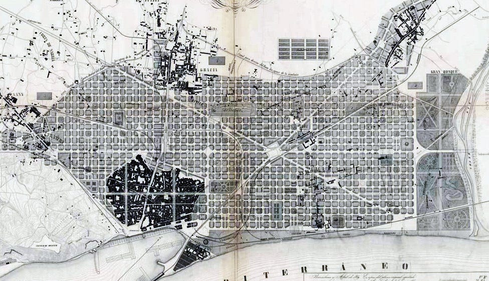
Often regarded as the father of modern urban planning, Cerdà approached the city scientifically. Rather than relying solely on aesthetics or monumentality, he carefully mapped Barcelona’s topography, transportation networks, housing conditions, and social inequalities. His work recognized that successful cities depend as much on geography and public health as on architecture.
His groundbreaking treatise, The General Theory of Urbanization (1867), even introduced the word urbanization, helping define an entirely new field of study.
Unlike the radial city plans common throughout Europe, which concentrated growth around a historic center, Cerdà envisioned an egalitarian grid that integrated old and new neighborhoods while distributing light, air, mobility, and public space more equitably.
Cerda collected data on the living conditions throughout the city, noting major discrepancies between the wealthiest and poorest parts of the city. He took detailed surveys of the topographical features and landscape of Barcelona. By compiling meticulous notes on both the physical and human geography of Barcelona, Cerda aimed to create a new city that alleviated the ills of urbanization.
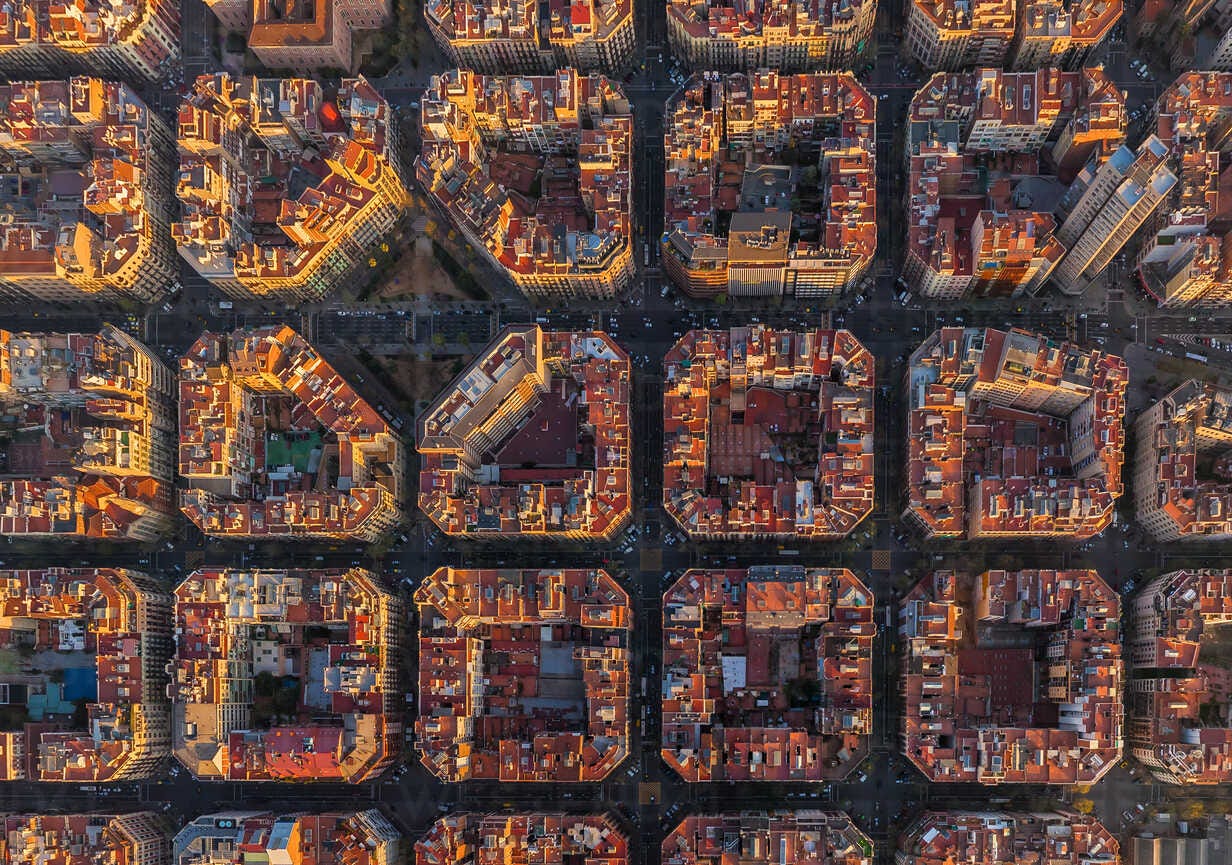
At the heart of Cerdà’s vision were the iconic manzanas, or city blocks, that today define Barcelona’s urban landscape.
Each block featured chamfered corners, creating distinctive octagonal intersections that improved visibility, circulation, and maneuverability. Streets were oriented approximately 45 degrees to maximize sunlight, while building heights were carefully limited in proportion to street widths to ensure ventilation and reduce overcrowding.
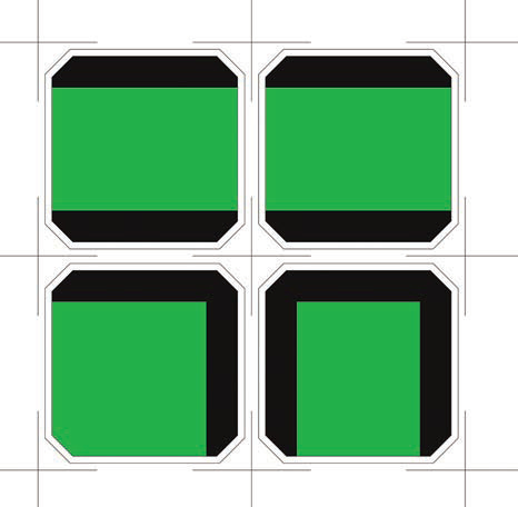
Perhaps most remarkably, Cerdà planned for every block to contain interior gardens and green spaces. Buildings only occupied some of the edges of the manzanas to allow for adequate green spaces on the interior, creating a series of green corridors. These interconnected courtyards would create a network of green corridors throughout the city, bringing nature into everyday urban life while improving public health and quality of life. New diagonal roads were also constructed across the Eixample, bisecting the blocks. Some previously existing roads remained, or were extended to connect with the old city- two notable examples include Passeig de Gracia and Ramblas de Catalunya.
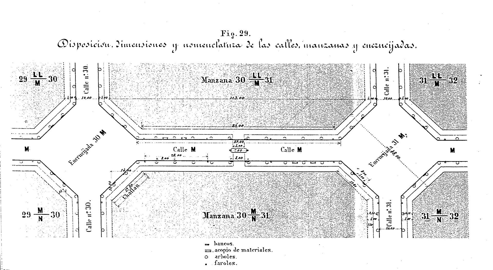
His design also anticipated future transportation needs. The chamfered intersections allowed horse-drawn vehicles—and, as Cerdà predicted, future “private locomotion carriages”—to navigate the city more efficiently. Although he could not have foreseen the rise of the automobile, his flexible street design proved remarkably adaptable more than a century later.
Like many ambitious planning projects, Cerdà’s vision was never fully implemented.
Although Cerdà had good intentions, some parts of his original plan were never fully realized due to real estate pressures. For example, most manzanas had all four sides occupied with buildings, oftentimes even taking up the interior space. This left very little room for green space and green corridors. In addition, many of the buildings were built taller than the original plan had envisioned.
Even so, the framework he created proved extraordinarily resilient. The generous street widths, regular grid, and adaptable block structure enabled Barcelona to respond to new urban challenges long after Cerdà’s lifetime.
By the late 20th century, Barcelona faced a familiar crisis.
Automobile traffic had transformed the city into one of Europe’s noisiest and most polluted urban environments. Congestion, declining air quality, and shrinking public spaces echoed many of the same challenges that had inspired Cerdà’s reforms more than 150 years earlier.
Rather than abandon its historic urban form, Barcelona adapted it.
Out of the dust arose the concept of the superblock (or superilla in Catalan), first attributed to architect Salvador Rueda in 1987. The superblock arranged manzanas in a 3 x 3 block, redirecting traffic around the outer edges and closing off the interior streets to cars. Tree canopy was increased throughout the city, including on major roadways. Within the superblock, the area was redeveloped for public spaces, including benches, playgrounds, and green spaces.
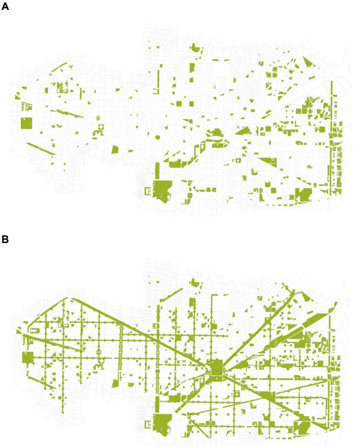
The first superblock was implemented in 1993, and 23 years later, in 2016, a long-term plan was implemented. Though the project is still currently in process, there have been notable improvements in areas that have already been superblock-ed.
The transformation has been dramatic. Streets once dominated by cars now accommodate playgrounds, public plazas, trees, cycling infrastructure, and community gathering spaces. In neighborhoods such as Sant Antoni, nitrogen dioxide concentrations have declined significantly while traffic volumes have dropped by nearly 90 percent, creating quieter, healthier, and more livable communities.
Barcelona’s greatest achievement is not simply its distinctive architecture or famous boulevards—it is its ability to continually reinvent itself without abandoning the geographic logic that shaped its past.
From the Roman street grid of the Gothic Quarter to Cerdà’s revolutionary Eixample and today’s internationally recognized superblocks, each era has responded to new social and environmental challenges through thoughtful urban design.
For urban planners, geographers, and city leaders, Barcelona offers an enduring lesson: the most successful cities are those that understand geography not as a constraint, but as the foundation for innovation. By integrating physical landscapes, public health, transportation, and human-centered design, Barcelona has become more than a beautiful city—it has become one of the world’s most influential laboratories for urban planning.
Castrezzati, Michele. “Barcelona’s Superblocks: Putting People at the Centre.” 28 Mar. 2023. https://citychangers.org/barcelona-superblocks/
Daniel Steiner. “Barcelona’s Map, Explained.” 29 Nov. 2025.
Nieuwenhuijsen, Mark, et al. “The Superblock Model: A Review of an Innovative URBAN Model for Sustainability, Liveability, Health and Well-Being.” Environmental Research, vol. 251, no. 1, 1 Mar. 2024, pp. 118550–118550, 10.1016/j.envres.2024.118550. https://www.sciencedirect.com/science/article/pii/S0013935124004547
Postaria, Ronika. “Superblock (Superilla) Barcelona—a City Redefined.” 31 May 2021. https://www.citiesforum.org/news/superblock-superilla-barcelona-a-city-redefined/
Rueda, Salvador. “Superblocks for the Design of New Cities and Renovation of Existing Ones: Barcelona’s Case.” Integrating Human Health into Urban and Transport Planning, 14 July 2018, pp. 135–153, 10.1007/978-3-319-74983-9_8. https://link.springer.com/chapter/10.1007/978-3-319-74983-9_8
Urbano, Judith. “The Cerdà Plan for the Expansion of Barcelona: A Model for Modern City Planning.” Focus, vol. 12, no. 1, 26 Feb. 2016, 10.15368/focus.2016v12n1.2. Accessed 4 Aug. 2026. https://digitalcommons.calpoly.edu/cgi/viewcontent.cgi?article=1323&context=focus
Thanks for reading The AGS Globe! This post is public, so feel free to share it.
Did you enjoy reading this? Support the American Geographical Society today with a donation of $50 to help us support Geography education.

Members of the American Geographical Society enjoy reduced-price access to AGS events and free access to the online version of Geographical Review.


You are invited to our 175th Anniversary globe signing event on September 15th at the Explorers Club in New York City, featuring renowned explorer, oceanographer, and astronaut Dr. Kathy Sullivan. Support the Society’s 175 Campaign with a gift of $175 or more and receive an invitation to this exclusive event, where you’ll have the opportunity to see one of the world’s most extraordinary historical artifacts gain its newest signature. Join us on September 15 as we celebrate the explorers who have shaped our understanding of the world—and help ensure that the spirit of exploration continues to inspire future generations.
Submit Lightning Talk and Exhibition Poster Proposals Today! Speak at our annual fall symposium, Geography 2050: Africa Shaping Tomorrow, taking place this November 19-20, 2026, at the Schomburg Center for Research in Black Culture in New York City! By 2100, over one-third of the world’s population will live in Africa, already the world’s youngest and fastest-growing continent, with profound implications for the interconnected human and environmental dimensions of the transformative demographic and technological boom across Africa. Submit proposals to speak at Geography2050 here!
Our Geography 2050 Trip Planning Page is Up! You can view information about this year’s venue and our partner hotels with Special Symposium Rates. Early birds can register for the lowest ticket price and book their stay at Aloft Harlem or the Renaissance New York Harlem Hotel at this special rate TODAY by going to the Geography 2050 Trip Planning page.
Comments
Nothing yet. Say the first thing.
Sign in to join the conversation.