
Welcome to new readers of the American Geographical Society’s weekly, the AGS Globe! The Globe shares articles on geography and geospatial topics, as well as exciting opportunities and news from our network. As the world revolves, geography evolves. The mission of the AGS Globe is to bring our storied legacy of exploration and thought leadership into the frontiers of the future.

By Lynn Cai
When people think of pre-Columbian cities in the Americas before European colonization, examples such as Tenochtitlan, Chichen Itza, or Cusco usually come to mind. However, few know that there is another pre-Columbian city located in the present-day United States: Cahokia. Known for its impressive mounds, Cahokia in the 12th century CE was the largest metropolitan area and the most complex political system in North America north of Mexico.
Cahokia was a dynamic urban center with large-scale cultural influence. That cultural influence is called the term “Mississippian.” The Mississippian culture in the Eastern Woodlands depended on an area of high natural and agricultural productivity, and absorbed much of the rural population in the development of Cahokia, transforming their labor from agriculture to public works. Archaeologists use “Mississippian” to refer to people who were part of a cultural tradition whose maximal expression occurred at Cahokia, and that was widespread across major portions of the Mississippi River valley, the Southeastern U.S., and beyond toward the Gulf Coast and as far north/northwest as Wisconsin and South Dakota. Cahokia had religious, political, and cultural exchanges over this vast area.
At its peak, the population of Cahokia was believed to be roughly between 10,000 and 40,000 people, rivaling the size of many European cities at the time. As it collapsed, its population reoccupied the countryside, and later, left the region. The ability to study the full course of a city’s life from development to collapse and abandonment is rare, and studying Cahokia reveals important insights on early urban life at the hub of a vast riverine trade network spanning North America. Despite the ancient city’s prominence in the Eastern Woodlands area during the Mississippian Period (900 - 1600 CE), much has yet to be uncovered about this settlement.
Cahokia is located in the American Bottom, a floodplain situated on the confluence of the Missouri, Illinois, and Mississippi Rivers in present-day Illinois. This is the tremendously fertile region of the Mississippi floodplain in Illinois, near the city of Saint Louis (Missouri state border). The floodplain can be nearly 11 miles (~18 km) wide. Cahokia is located near the confluence of the Missouri, Mississippi, and Illinois Rivers. The fertile soil of this area encouraged agriculture, with maize (corn) a particularly popular crop.
Settlement within this region dates back to the Late Woodland period (~600 CE). Since the American Bottom was frequently inundated with flooding from the nearby rivers, Indigenous peoples built their homes on nearby higher ground. Late Woodland society changed dramatically around 1000 CE when maize became an important agricultural food staple and was produced more intensively. Population rapidly expanded, and Cahokia, which had been an ordinary Late Woodland settlement, grew enormously in size and complexity. The early stages of moundbuilding eventually began around the 10th-11th century CE.
At its peak, between approximately AD 1050-1150, Cahokia was composed of three neighboring precincts on either side of the Mississippi River: the Cahokia core and the East St. Louis precinct were located on the east side of the river (Illinois), while the St. Louis precinct was located on the west side of the river (Missouri). These precincts covered approximately 6 square miles (15.5 sq km). The three precincts were all major mound centers, meaning they had civic-ceremonial structures in the form of earthen mounds. The earthen mounds were used for burials, and the largest ones, such as Monks Mound, were also stages for great religious ceremonies with temples on their platforms and houses of the chiefs. Greater Cahokia (combining the three centers) comprised over 120 earthen mounds. There were hundreds of houses around these mounds. Perhaps 15,000–20,000 people resided in Greater Cahokia. Another 30,000-40,000 people lived in the surrounding rural countryside.
If one thinks about Europe at the time of Cahokia’s peak occupation, it is notable that Cahokia was larger than Paris and London. Indeed, there was not another city of Cahokia’s size in what is now the U.S. until the city of Philadelphia in the late 18th century. With no metal tools, horses, or wheeled carts, Indigenous Mississippian builders constructed a vast, 6-square-mile (15.5 sq km) urban center featuring 120 earthen mounds, the largest ancient civilization between the deserts of Mexico and the Arctic.
Cahokia was built and organized around particular cosmological worldviews. The city’s built landscape, including major mounds, a causeway, and woodhenge, all enacted a cosmology based on celestial alignments, sacred materials, and burial practices.
The settlement of Cahokia initially consisted of individual villages. The layout and the development of the villages were considered one of the earliest forms of centralized urban planning within the present-day United States. The history of Cahokia mirrored typical urban development patterns, beginning as a small village or collection of villages, growing to a town, and finally urbanizing into a bustling metropolis, in addition to processes of suburbanization. Archaeologists and historians divide the history of Cahokia into 5 distinct phases: The Emergent Mississippian (925-1050 CE), Lohman (1050-1100 CE), Stirling (1100-1200 CE), Moorhead (1200-1275 CE), and Sand Prairie (1275-1350 CE).
During the Emergent Mississippian Phase, each village was centered around a courtyard with communal buildings that were used for several purposes ranging from storage to religious. Eventually, the villages developed into a centralized town with hierarchical power and complex urban planning. This coincided with a big increase in population. A pivotal point occurred in 1050 CE when Cahokia saw explosive population growth, ushering in the Lohman Phase. During this era, civilization became more urbanized and complex with a concentrated hierarchy. Power was centralized, and this was reflected in the architecture. The built landscape of Cahokia demonstrates that social hierarchies existed amongst its population.
Massive monuments were constructed, continuing work that was started from the Emergent Mississippian phase. This included Monk’s Mound, the largest monumental structure of Cahokia. Monk’s Mound held significant religious, political, and ceremonial power- it was the residence of the polity’s leader. The massive monument was flanked by plazas on all four sides, including the Grand Plaza. The orientation of the mounds and the plaza followed traditional Native American cosmology, with Monk’s Mound acting as the axis mundi, or the center of the universe. A palisade, or a fence, was constructed around this structure during the Stirling Phase, and rebuilt multiple times well into the Moorhead Phase. The enclosure of Monk’s Mound physically and symbolically separated the ruling elite from the commoners. The rest of the settlement radiated from the mound and the grand plaza.
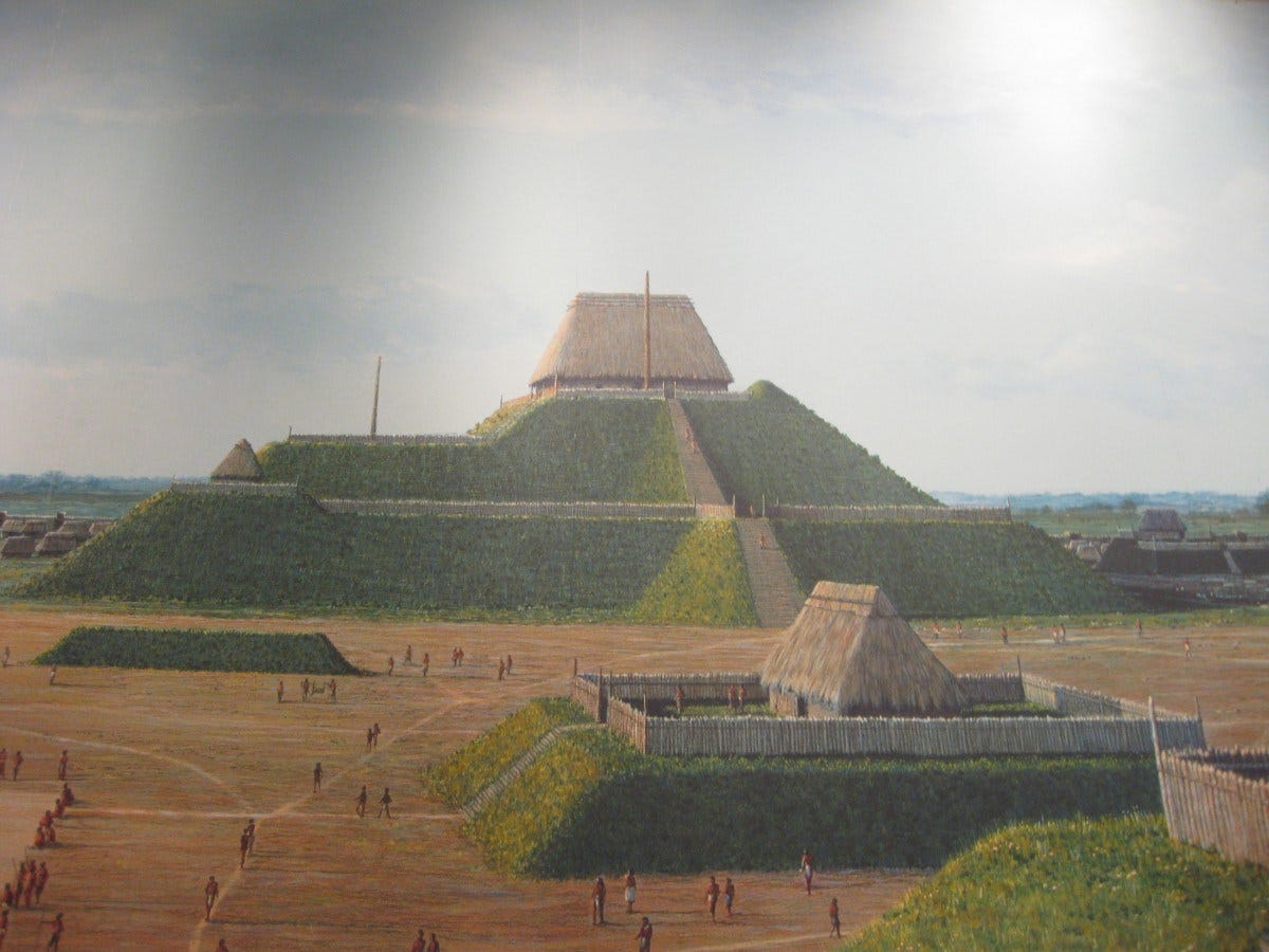
The construction of mounds was labor-intensive, with workers transporting and piling dirt with baskets. The dirt was collected from nearby dug-out pits (aka borrow pits) utilizing hoes and spades made from chert, a kind of sedimentary rock. After dirt was harvested, the remaining pit acted like a landfill, filled with trash. An estimated 615,000 cubic meters (21,718,520 cubic feet) of dirt was used to construct Monk’s Mound. Buildings constructed on top of the mounds usually consisted of simple wattle and daub (straw and mud) structures. Besides the political and religious/ceremonial purposes, the mounds were also used for practical purposes including storage and communal gathering.
In addition to mounds, the inhabitants of Cahokia also constructed 5 woodhenges. These wooden structures consisted of red cedar posts arranged in a circle and had calendrical functions, measuring summer and winter solstices in addition to holding cosmological symbolism. By tracking celestial cycles using wooden posts aligned to the equinoxes and solstices, Cahokians organized their agricultural calendar.
After approximately AD 1200, construction of massive works continued well into the Stirling and Moorhead phase, even though the population started to decline. As more people moved to the nearby rural areas, the elites were no longer able to wield extensive power as they did during the previous eras. The population decline followed by migration resulted in a labor shortage, increasing the workload demands on residents who remained.
Anthropologist Joseph Tainter offers an influential theory of diminishing returns to complexity (Tainter and Taylor, 2014) that could explain the collapse of Cahokia. Tainter’s model helps explain why an increasingly centralized political system may have become unsustainable as agricultural productivity and available labor declined. Ultimately, the energy and labor costs of maintaining its political structure exceeded the agricultural benefits it provided, resulting in regional abandonment.
Cahokia was eventually abandoned around 1350 CE. While there are several theories for the abandonment, ranging from socio-political unrest to environmental factors such as flooding, a definitive answer remains elusive. Nonetheless, it was likely a mix of both environmental and political factors that led to the city’s eventual demise. The remaining residents migrated out to the Midwest and the Mid-South. Today, various tribes within the region share possible ancestral ties to the original inhabitants of Cahokia, including the Choctaw, Osage, Chickasaw, Omaha, Peoria, and Pawnee peoples.
References
Benson, Larry, et al. Cahokia’s Boom and Bust in the Context of Climate Change. 2009.
Kelly, John E., and James A. Brown. “Cahokia: The Processes and Principles of the Creation of an Early Mississippian City .” Space and Place in Early Urban Societies, edited by Andrew Creekmore and Kevin Fisher, Cambridge, 2014.
Puaketat, Timothy. “Cahokia: A Pre-Columbian American City | Gilder Lehrman Institute of American History.” Gilderlehrman.Org, 2024, https://www.gilderlehrman.org/history-resources/essays/cahokia-pre-columbian-american-city. Accessed 13 July 2026.
Smith, Jen Rose. “The US’ Lost, Ancient Megacity.” Www.Bbc.Com, 13 Apr. 2021, https://www.bbc.com/travel/article/20210412-the-us-lost-ancient-megacity. Accessed 13 July 2026.
Tainter, Joseph A. “Cahokia: Urbanization, Metabolism, and Collapse.” Frontiers in Sustainable Cities, vol. 1, 3 Dec. 2019, 10.3389/frsc.2019.00006. Accessed 14 July 2026.
Tainter, J. A., Taylor, T. G. (2014). Complexity, problem-solving, sustainability and resilience. Build. Res. Inf.42, 168–181. 10.1080/09613218.2014.850599
Thanks for reading The AGS Globe! This post is public, so feel free to share it.
Did you enjoy reading this? Support the American Geographical Society today with a donation of $50 to help us support Geography education.

Members of the American Geographical Society enjoy reduced-price access to AGS events and free access to the online version of Geographical Review.


Submit Lightning Talk and Exhibition Poster Proposals Today! Speak at our annual fall symposium, Geography 2050: Africa Shaping Tomorrow, taking place this November 19-20, 2026, at the Schomburg Center for Research in Black Culture in New York City! By 2100, over one-third of the world’s population will live in Africa, already the world’s youngest and fastest-growing continent, with profound implications for the interconnected human and environmental dimensions of the transformative demographic and technological boom across Africa. Submit proposals to speak at Geography2050 here!
Our Geography 2050 Trip Planning Page is Up! You can view information about this year’s venue and our partner hotels with Special Symposium Rates. Early birds can register for the lowest ticket price and book their stay at Aloft Harlem at this special rate TODAY by going to the Geo2050 Trip Planning page.
Comments
Nothing yet. Say the first thing.
Sign in to join the conversation.