
Life in the USA is not normal. It feels pointless and trivial to be talking about small looks at the fascinating natural world when the country is being dismantled. But these posts will continue, as a statement of resistance. I hope you continue to enjoy and learn from them. Stand Up For Science!
Post #438
Earth’s continents are not simple blocks occupying the land areas we call “continents.” Each of them is an amalgamation of smaller pieces that have come together over time to produce the large, more-or-less stable continents we have today. Those pieces include cratons, old, strong, stable cores, and intervening or surrounding material attached to each other during collisions. Craton, you recall, is from a Greek word meaning strong.
Those collisions (orogenic belts, where orogeny means mountain building) are sites of deformation where separate plates and terranes interact. For relatively recent collisions, like those between Siberia and Baltica (the East European Craton), the evidence is still obvious – the Ural Mountains, formed from about 320 to 190 million years ago. But the likely Himalayan-sized mountain range that resulted when the Wyoming and other small cratons collided with the central core of North America is gone – it underlies the surface of western North Dakota and eastern Saskatchewan, with no significant evidence on the surface, because it formed 1,800 million years ago – long enough for even huge mountains to be eroded away.
In many places the positions where these various blocks attached to each other are marked by zones called sutures. Like medical sutures, they attach discrete terranes together but with igneous bodies, complex faulting, metamorphism, and chemical exchange. Sutures are narrow, usually elongate features that are often discernible in various data sets. Because in many cases oceanic crust may be caught between two blocks and can be part of the suture, magnetic data often reveal sutures in the subsurface because oceanic crust is typically magnetic (contains a lot of magnetite) compared to other rocks.
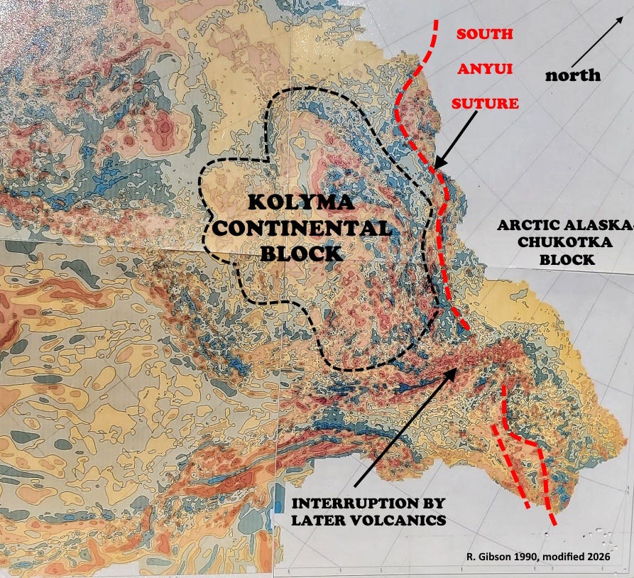
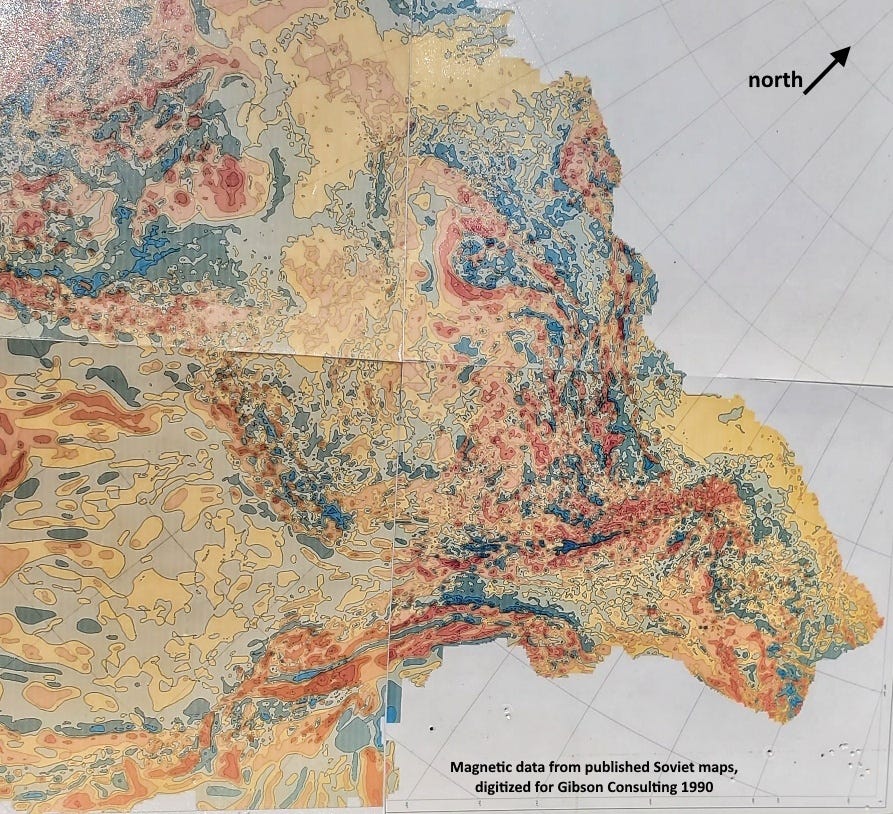
The magnetic map of the former Soviet Union reveals the South Anyui Suture, where the Chukotka and Kolyma blocks came together as a small Mesozoic ocean closed, about 115 million years ago. The linear zone of discontinuous magnetic highs marked as the red dashed line on my interpreted map above is the remnant of oceanic crust trapped between the two more or less continental blocks.
When I worked on these magnetic maps in 1990, the South Anyui zone was known, but the plate-tectonic framework of it and all of far northeastern Siberia were still being worked out (Churkin, 1983, Tectonostratigraphic terranes of Alaska and northeastern USSR – a record of collision and accretion: in Accretion Tectonics of the Circumpacific Regions, Hashimoto and Uyeda, eds., Terra Scientific Publishing, Tokyo; and Stavsky, 1990, Plate tectonic and palinspastic reconstructions of the Anadyr-Koryak region, northeast USSR: Tectonics 9:1, p. 81-101).
At the time I was working on this region there were suggestions that the Chukotka and Arctic Alaska terranes were parts of one larger body, but more recent work supports that idea strongly (Amato and others, 2015, Tectonic evolution of the Mesozoic South Anyui suture zone, eastern Russia: A critical component of paleogeographic reconstructions of the Arctic region: Geosphere 11(5): 1530-1564).
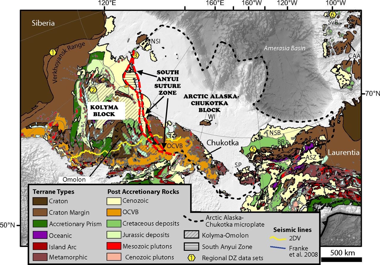
Most of this region today is tectonically part of North America, as we saw in this earlier post about the Sea of Okhotsk. The diffuse, ill-defined boundary goes approximately through the Verkhoyansk Range, brown at upper left on the map above, making Kolyma and Chukotka tectonically connected to Alaska. This boundary is not a very active one today, and to a large extent North America and Siberia/Eurasia are locked together along it.
The Brooks Range-North Slope in Alaska has often been interpreted as a block that rotated away from Arctic Canada to form the Amerasia Oceanic Basin (upper right on map above; often called the Canada Basin). If that terrane was attached to Chukotka, it’s reasonable to see the South Anyui zone as a consequence of the rotation of the Chukotka portion so as to collide with Kolyma.
We’ve looked at some other sutures in previous posts, one in Georgia (USA) and one in northwestern Russia.
Comments
Nothing yet. Say the first thing.
Sign in to join the conversation.