
In Part 2 of my series on the Empire Prairie, I mentioned that the prairie we now call the “Empire Prairie” has had a number of other names: “Fountain Prairie,” “Arlington Prairie,” and “Sun Prairie,” to name a few. I also put forth the hypothesis that “Empire Prairie” really referred to a smaller fragment of the prairie as it existed in the mid- to late-1800s rather than the original prairie that was surveyed in the 1830s. But if “Empire Prairie” referred to the smaller section of prairie that existed in the Poynette area after decades of woody encroachment and plowing had fragmented the original grassland into smaller pieces, what, then, was the name for the full prairie, as it existed in the 1830s?
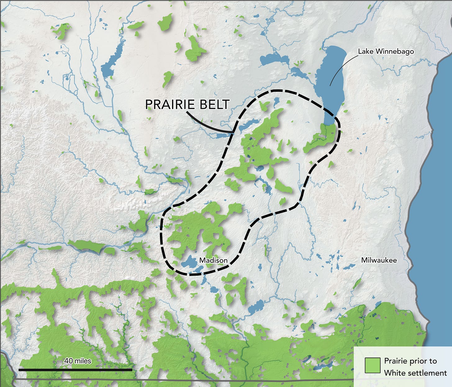
To answer that question, we first need to establish what prairie we’re talking about. On the one hand, it is possible to discern a discrete 200-square-mile grassland from the 1830s land survey. But while that shape exists on paper, the decision to consider just that single treeless expanse as the prairie is arbitrary. In the 1830s, a belt of prairie stretched from Madison to Lake Winnebago (see figure below).1 Although 1830s surveys show that there were interruptions to the prairie, these interruptions were largely oak savanna (and sometimes very thinly timbered oak savanna at that). So when we read descriptions of the prairie north of present-day Madison, we can’t be sure if writers were describing the 200-square-mile chunk of uninterrupted grassland that was captured on early survey maps, or the belt of prairie running to Lake Winnebago.
As for the original name of the prairie (whatever its boundaries may be), one of the earliest names I’ve been able to track down comes from Juliette Augusta Kinzie’s 1856 memoir, in which she chronicles her 1831 return trip to Fort Winnebago from Chicago. That journey included a trip across the prairie belt (in the area now considered the Empire Prairie), which she says was known as the “Twenty-mile Prairie.”2 While the name “Twenty-mile Prairie” might suggest to modern readers that the prairie extended twenty miles in every direction, I’d argue it’s equally plausible that it was named simply for the fact that it took twenty miles to cross traveling north–south, with no judgment on its northeast–southwest length.
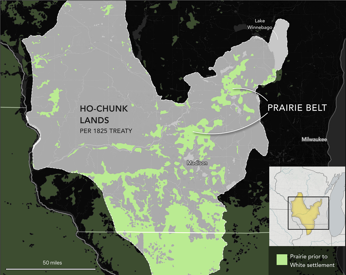
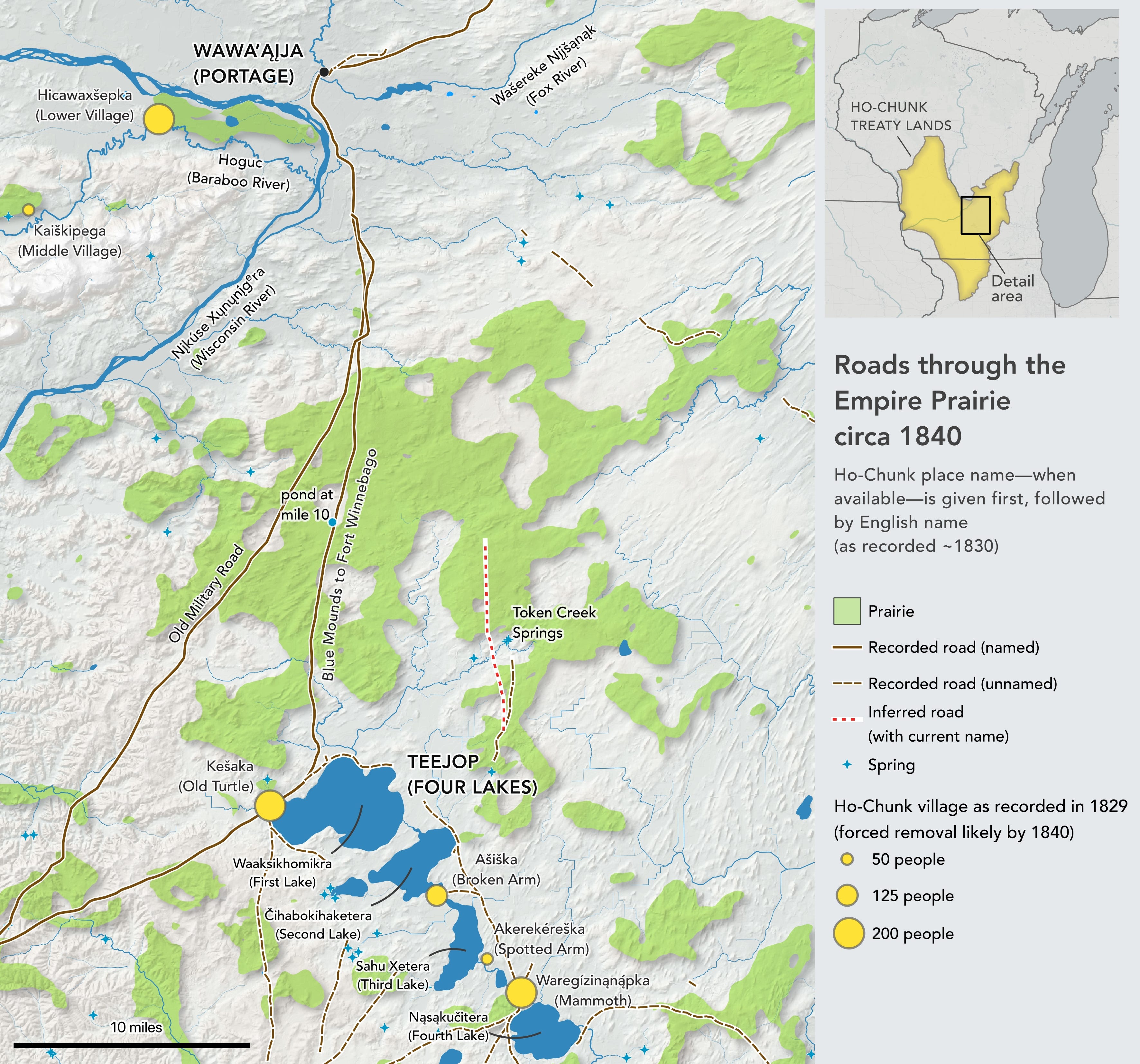
The earliest recorded name for the prairie that I’ve found comes from Starin’s 1840 diary of his travels in Wisconsin. In addition to writing about the poor moral character of Madison’s residents (“The people are very avaricious, are professed enemies & take every possible advantage of strangers”), he also describes a twenty-three-mile journey across what he calls “Winnebago prairie.”3 “Winnebago” is an exonym for the Ho-Chunk people, and was commonly used in the 1800s by White settlers. So translated to contemporary language standards, Starin was really calling the grasslands north of Lake Mendota “Ho-Chunk Prairie.” It’s not clear to me if that was a commonly-used name for the prairie, but it’s not surprising that the grassland would come to be associated with the Ho-Chunk. As shown in the map below, at the time of White settlement in Wisconsin, the Empire Prairie—and the rest of the prairie belt it belonged to—was within Ho-Chunk lands.
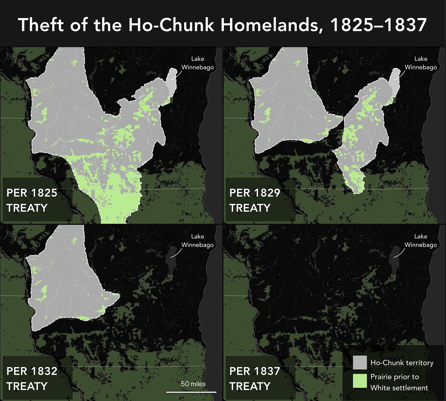
By 1832, the U.S. government had coerced the Ho-Chunk into ceding all of their territory east of the Wisconsin River (including the prairie belt mentioned above), and in 1837 the U.S. government coerced the Ho-Chunk to cede all remaining territory within present-day Wisconsin (see map below). Despite the theft of their lands by the U.S. government, many Ho-Chunk remained in—or continued visiting—lands east of the Wisconsin River. It’s not clear whether the grassland Starin called “Winnebago Prairie” was named in recognition of its location on Ho-Chunk soil, or because of continuing Ho-Chunk presence in its vicinity. In his 1877 history of Burke Township, John Douglas, writing about a trail through the prairie, claims that “early settlers frequently saw as many as five hundred to one thousand Indians, with their wives and little ones, pass and repass in a week.”4 I’m reluctant to take Douglas’s words at face value (late 1800s recollections of American Indian history can be a bit imaginative), and Douglas provides no insight into which Indigenous nation the travelers belonged to. But taken with Starin’s naming of the “Winnebago Prairie,” it suggests a Ho-Chunk presence in the grasslands north of Madison.
I have not yet found any Ho-Chunk names for the so-called “Empire Prairie,” or for the band of highland prairie that stretched northeast from present-day Madison. But the Empire Prairie lay between two areas with significance to the Ho-Chunk: Teejop (the Four Lakes area) and Wawa’ąįja (the portage between the Fox and Wisconsin rivers). In the early 1830s, Teejop was home to at least four Ho-Chunk villages, and the area west of Wawa’ąįja was home to at least three villages along the Hoguc (Baraboo River).
Beyond Douglas’s claim of Indigenous travelers on the prairie between Four Lakes and Portage, I have found additional indirect evidence that Ho-Chunk people traveled across the so-called “Empire Prairie” with relative frequency. In an 1829 map, a path is drawn between Four Lakes and Portage, which certainly suggests a Ho-Chunk road. It’s possible this was a road created by White settlers to get from Portage to Blue Mounds, but given that the first White settler had arrived in Blue Mounds only the prior year (to illegally occupy and mine unceded Ho-Chunk lands), that seems less likely.
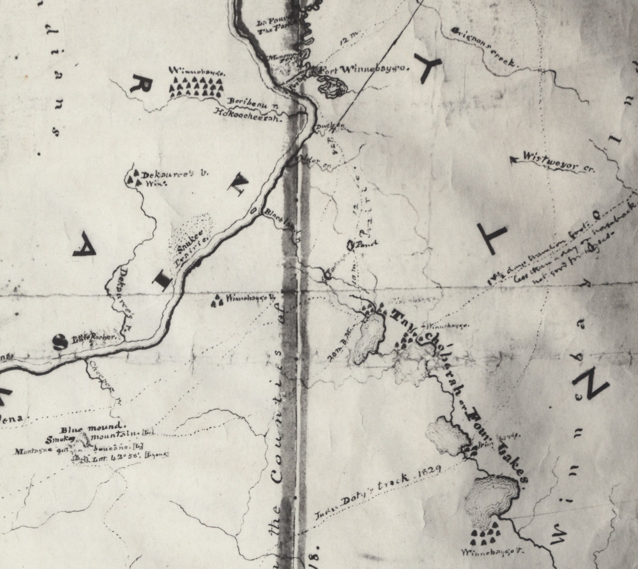
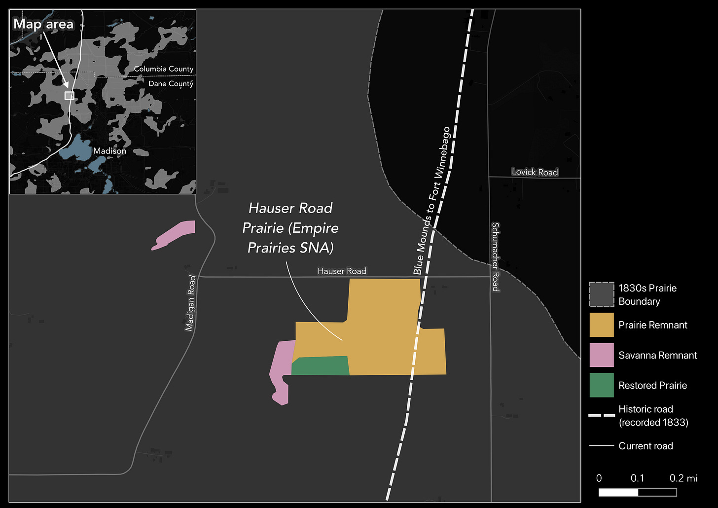
When the Empire Prairie region was surveyed in the early 1830s, a road between Four Lakes and Portage was included on official plat maps and labeled as the road between Fort Winnebago and Blue Mounds. I cannot say with certainty that the Blue Mounds–Fort Winnebago road is the same trail as in the 1829 map, but there is strong evidence: the 1829 map labels a pond ten miles north of Four Lakes, and the Blue Mounds–Fort Winnebago road intersects a pond ten miles north of Four Lakes (and ponds are very rare in the upland prairie). We also know that a road from Blue Mounds to Fort Winnebago existed in 1829, because that road was used to define the western boundary of Ho-Chunk territory in the 1829 treaty in which the Ho-Chunk ceded one-third of their lands to the U.S. government. Amazingly, the path of this historic road runs right through Dane County’s largest remnant of the Empire Prairie: Hauser Road Prairie (see map below).
Parts of the Blue Mounds to Fort Winnebago road would later be incorporated into the Old Military Road, which connected Fort Howard (in Green Bay) and Fort Crawford (in Prairie du Chien) by way of Fort Winnebago. I have seen many claims that the Old Military Road largely followed established Ho-Chunk trails, but I have not been able to verify these claims. H. E. Cole, for instance, in his 1925 article on the Old Military Road, writes that the road largely followed “well-trodden Indian trails,” but Cole also claimed that the road skirted the northeastern shore of Lake Mendota, which Durbin and Durbin show to be false.5 So Cole is not a reliable source. Durbin and Durbin, for their part, make their own claims about roads replacing Ho-Chunk trails, describing an “existing wagon trace running along the Indian trail from Prairie du Chien.” But their supporting evidence mentions only an existing road and makes no mention of its origin (Ho-Chunk or otherwise).6 So while it’s probable that the trail existed before White settlement, I have not found direct evidence of that fact.
James Doty, one of the road’s planners, made a point of contrasting the straight line of the Old Military Road with the existing trails, writing that “travelling has been blindly confined to the old Indian trails, which frequently lead, by very circuitous and unfavorable routes, from point to point, visiting in their course villages and other points out of the general course of the line.”7 Doty, for his part, may have been exaggerating the state of existing roads for the sake of drumming up support for his new road. But if Doty is reliably reporting the existence of Indigenous trails, then perhaps the path from Blue Mounds to Fort Winnebago, with its detour to Four Lakes, is one of the “circuitous” Indigenous routes Doty bemoaned.
The other major recorded route through the prairie—possibly a Ho-Chunk road—is a trail passing Token Creek Springs, first attested to in an 1845 deed of sale as the “Fort Winnebago road.”8 Plat maps from the early 1830s show an unnamed road running from Four Lakes to Token Creek Springs, but do not show it as extending north beyond that point (see image above). I have not found any historical maps clearly labeling that road, but there still exists a road called “Portage” running through Token Creek, so we can hypothesize it follows the old route to Portage. I’m not sure that this route to Portage followed the original trail, given that the trail recorded in the early 1830s from Four Lakes to Token Creek Springs is a bit east of the road currently known as Portage, but it seems plausible that there was a Ho-Chunk road in that general area. John Douglas, writing in 1877, claimed that “the Indian trail from Koshkonong and Third lakes [sic], to Fort Winnebago (now Portage City), passed through the town, near the Indian Spring, on section 26. It was a well beaten track, and is still seen, where cultivation has not obliterated its traces.”9 The road from Third Lake (present-day Waubesa) to Token Creek Springs is recorded in the 1830s survey, so there is corroborating evidence for that leg of the road, and it seems highly plausible that it was a Ho-Chunk travel corridor. The leg from Token Creek Springs to Fort Winnebago is not recorded on early maps, so we’d have to take Douglas at his word (which, as mentioned, I’m reluctant to do).
Douglas goes on to claim that the area around Token Creek Springs, which lies along one edge of the prairie, had once been an “old Indian camping ground.”10 Again, Douglas is not very precise, and it’s not entirely clear what he means by that. He could be saying that the Ho-Chunk had resided there in recent memory, or possibly he means that archaeological evidence (such as mounds) suggested prior habitation. Indeed, he does mention two circular mounds within a mile of the putative camping ground.11 Either way, while it seems entirely plausible that it was a camping ground at some point, we cannot be sure that the Ho-Chunk had resided there in recent centuries.
Anyway, that’s all I have for today. I’ve done my best to research the Ho-Chunk history of the Empire Prairie, but there’s more work to be done. Let me know in the comments if there’s anything I’ve missed!
One contemporaneous verbal description of this prairie belt comes from politician and land speculator James D. Doty, who described a “rolling prairie, extending from the latter point [Lake Winnebago], with but few interruptions, to Fort Crawford [in Prairie du Chien].” T. D. Doty and A. J. Center, “Report of the commissioners appointed, by direction of the Secretary of War, to locate and survey the route for a military road from Fort Howard to Fort Crawford, via Fort Winnebago,” enclosure in Thomas S. Jesup to Lewis Cass, February 4, 1835, in Roads in Michigan. Letter from the Secretary of War, Transmitting the Information Required by a Resolution of the House of Representatives of the 26th Ultimo, in Relation to Certain Roads in the Territory of Michigan, 23d Cong., 2d sess., H. Doc. 132 (Washington, DC: Gales & Seaton, 1835), 3.
Kinzie observes that it was actually only sixteen to eighteen miles to cross it. Juliette Augusta Kinzie, Wau-Bun: The Early Day in the Northwest (Carlisle, MA: Applewood Books, 2010), facsimile of the 1873 edition (Philadelphia: J. B. Lippincott & Co., 1873; originally published New York: Derby & Jackson, 1856), 258.
Frederick J. Starin, “Diary of a Journey to Wisconsin in 1840,” The Wisconsin Magazine of History 6, no. 2 (1922): 212.
John Douglas, “Burke,” in Madison, Dane County and Surrounding Towns (W. J. Park & Co., 1877), 393.
Richard D. Durbin and Elizabeth Durbin, “Wisconsin’s Old Military Road: Its Genesis and Construction,” The Wisconsin Magazine of History 68, no. 1 (1984): 25, note 86.
Road—Green Bay to Prairie du Chien. Letter from the Secretary of War, Transmitting Further Information in Relation to the Road from Green Bay to Prairie du Chien, 22nd Cong., 1st sess., H. Doc. 83 (Washington, DC, 1832): 1–2 (Cass to Andrew Stevenson, January 28, 1832; J. H. Plympton et al. to Cass, [undated]); and American State Papers: Military Affairs, vol. 4:815–16, 849–50 (Wool to Cass, December 23, 1831; Garland to Cass, December 15, 1831; Brevoort and Doty to Macomb, January 20, 1829 [extract]; Cass to Stevenson, January 4 and January 28, 1832; Plympton et al. to Cass, [undated]).
Doty and Center, “Report of the commissioners,” 2.
George A. Spaulding and Mary Spaulding to Charles Lawrence, deed of sale, June 21, 1845, excerpt reproduced in “Record Center Highlights,” Dane County Historical Society Newsletter 35, no. 1 (Spring 2017): 5.
He also mentions that, due to plowing, they had already begun to disappear. Douglas, “Burke,” 394.
No posts
Comments
Nothing yet. Say the first thing.
Sign in to join the conversation.