
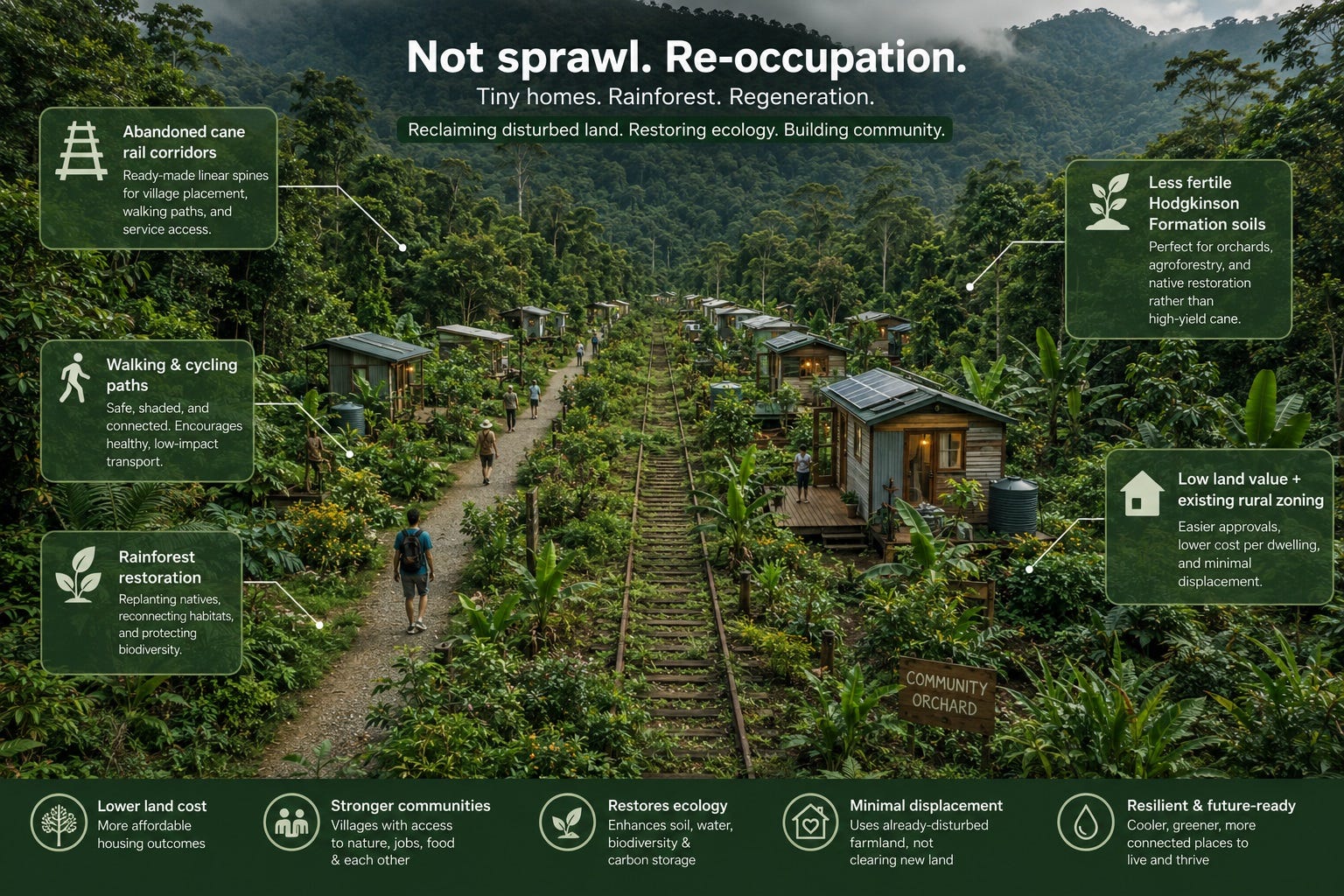
These districts have three defining features that make them ideal:
Abandoned cane rail corridors → ready‑made linear spines for village placement, walking paths, and service access.
Less fertile Hodgkinson Formation soils → perfect for orchards, agroforestry, and native restoration rather than high‑yield cane.
Low land value + existing rural zoning → easier approvals, lower cost per dwelling, and minimal displacement.
This is not sprawl. It’s re‑occupation of already‑disturbed farmland in a way that restores ecology and provides housing.
Place villages every 1–2 km along the former rail spurs.
Use the old rail bed as:
a walking/bike spine
a service corridor for water, power, and maintenance
a cultural pathway linking villages
Where bridges washed out decades ago:
Build tiny villages on the higher terraces above the creek.
Restore the creekline below as native forest and wetland.
The village becomes a safe, elevated node, while the floodplain becomes ecological infrastructure.
These soils aren’t great for cane, but they’re perfect for:
mixed fruit orchards
macadamia and native nut species
agroforestry (silky oak, black wattle, hoop pine)
native woodland restoration
This turns “poor farmland” into productive, biodiverse land.
20–40 tiny homes arranged around a shaded green.
Elevated designs for flood resilience.
Verandahs, deep eaves, cross‑ventilation for tropical comfort.
Worker housing + affordable rentals + small ownership lots.
Designed for Hodgkinson soils:
Citrus (thrives in poorer soils)
Mango (tolerant and productive)
Avocado (in better pockets)
Macadamia (native, hardy)
Banana in wetter gullies
Understory: sweet potato, lemongrass, native groundcovers.
Replant with local species: melaleuca, acacia, eucalypt, lomandra.
Restore riparian corridors along Woopen Creek and Liverpool Creek.
Create continuous wildlife corridors between villages.
Fire‑smart design: low‑fuel species near homes.
Villages provide stable, dignified homes for:
orchard workers
agroforestry crews
seasonal harvest teams
local service workers (hospitality, aged care, trades)
Across 8–12 villages:
20–60 homes each → 160–720 dwellings total
Affordable, modest, ecological homes
Reduces pressure on Innisfail, Tully, Silkwood, and Mission Beach
This is real supply, not speculative development.
Where bridges washed out:
Let the floodplain return to wetland and forest.
Plant melaleuca, swamp mahogany, lomandra, native reeds.
Build elevated boardwalks for access and recreation.
On slopes and terraces:
Hoop pine, black wattle, ironbark, blue gum.
Understory shrubs and grasses.
Long‑term carbon sink + cooling + habitat.
Rows of:
silky oak
black wattle
native nut trees
timber species for future harvest
This blends ecology with economic resilience.
Rainwater tanks + bore + shared purification.
Reed‑bed wastewater treatment feeding orchards.
Solar micro‑grids with battery banks.
Villages linked for redundancy.
Internal walking/bike paths.
Shared electric utility vehicles.
Shuttle link to Tully or Innisfail.
Ecological commitments
Shared maintenance days
Worker protections
No return to monoculture
Forest corridors protected in perpetuity
Co‑design with Traditional Owners
Cultural burning practices
Naming of forest corridors
Ceremonial spaces along creeklines
Already disturbed farmland → no need to clear new land.
Abandoned rail corridors → ready‑made village spines.
Washed‑out bridges → natural floodplain restoration zones.
Poor soils → ideal for orchards, agroforestry, and forest.
Low land value → affordable housing at scale.
Close enough to towns → not isolated, but still rural.
This is regenerative rural housing, not sprawl. It’s a way to heal land, house workers, and add supply in a region that needs all three.
If you want, I can now sketch:
a map‑style layout of the Woopen Creek–Japoonvale network
a one‑page concept brief suitable for planners or councils
a visual diagram of the orchard–village–forest rings
a policy rationale explaining how this fits into QLD housing strategy
Just tell me which direction you want to take this next.
All three please.
See my thinking
Purpose and context
Abandoned cane land: Former sugar cane plantations in Woopen Creek and Japoonvale, with disused rail corridors and washed-out bridges.
Hodgkinson Formation soils: Less fertile than nearby basalt, now underused and low-value—ideal for mixed orchards, agroforestry, and native restoration rather than intensive cane.
Strategic aim: Convert degraded farmland into a network of regenerative tiny villages that provide worker housing and contribute to the regional housing supply.
Core design pattern
Distributed villages: 5–12 small villages placed along former cane rail alignments and higher terraces above creeks.
Concentric rings:
inner housing cluster (20–60 residents per village)
middle orchard and garden ring
outer native forest and corridor ring
Rail spine: Old cane rail beds become walking/bike paths, service corridors, and cultural links between villages and the nearest town.
Housing contribution
Worker housing: Stable, dignified homes for orchard workers, agroforestry crews, and local service workers.
Regional housing: Across the network, 160–720 dwellings (depending on village size), easing pressure on nearby towns while avoiding speculative sprawl.
Tenure mix: Owned tiny homes, long-term rentals, and community/co-op dwellings.
Ecological restoration strategy
Riparian repair:
Restore creeklines where bridges washed out as wetlands and native forest.
Plant melaleuca, swamp mahogany, reeds, and native grasses to stabilise banks and improve water quality.
Woodland and agroforestry:
Re-establish native woodland on slopes and terraces (eucalypt, acacia, hoop pine, understory shrubs).
Integrate agroforestry rows (silky oak, black wattle, native nuts, timber species) for long-term economic and ecological resilience.
Corridor design: Continuous wildlife and shade corridors linking villages, reducing heat and supporting biodiversity.
Infrastructure and governance
Water: Rainwater tanks, bore supply, and small-scale purification; reed-bed wastewater treatment feeding orchards where safe.
Energy: Solar micro-grids with batteries, villages linked for redundancy and optional grid connection.
Transport: Internal walking/bike paths, shared electric utility vehicles, shuttle links to nearby towns for services and schooling.
Village charter:
ecological commitments (no return to monoculture, protection of forest corridors)
shared maintenance and harvest days
worker housing protections and clear tenure rules
Collaboration with Traditional Owners:
co-design of species selection, cultural burning, naming of corridors, and ceremonial spaces along creeklines
recognition of Country and historical use of the landscape.
text
                     [Nearest Town]
                          |
                          |  (road / bus link)
                          V
                ============================
                ||   Former Cane Rail     ||
                ||   Alignment Spine      ||
                ============================
        (Native forest + creek corridor running roughly parallel)
        ~~~~~~~~~~~~~~~~~~  Woopen / Liverpool Creek  ~~~~~~~~~~~~~~~~~~
   V1: Village Node A
   -------------------
   [Outer Ring]  Native Forest & Corridor
       [Middle Ring]  Orchards & Gardens
           [Inner Core]  Tiny Homes + Commons
   - Located on higher terrace above old washed-out bridge site
   - Path down to restored wetland / riparian forest
   ---- 1–2 km along spine ----
   V2: Village Node B
   -------------------
   [Outer Ring]  Native Forest
       [Middle Ring]  Citrus / Mango / Macadamia Orchards
           [Inner Core]  Worker Housing Cluster
   - Service track connects to agroforestry blocks upslope
   ---- 1–2 km along spine ----
   V3: Village Node C
   -------------------
   [Outer Ring]  Woodland + Timber Agroforestry
       [Middle Ring]  Mixed Fruit + Market Garden
           [Inner Core]  Tiny Homes, Co-op Market, Tool Shed
   (Repeat pattern for additional nodes: V4, V5, etc.)
   Each node:
   - Linked by the old rail alignment (now path + service corridor)
   - Has spur tracks/paths to orchards and forest blocks
   - Connects via shuttle/road to the nearest town
Role:
Provides human-scale, permanent housing for workers and residents.
Hosts the commons building (shared kitchen, meeting room, cool store, tools).
Flows:
People: daily movement to orchards, forest, and paths; social life centred around the green.
Water: rainwater captured from roofs, some greywater directed to treatment systems.
Energy: solar generation on roofs feeding the village micro-grid.
Role:
Produces food (fruit, nuts, vegetables) and modest income.
Acts as a transition zone between housing and forest, with high biodiversity.
Flows:
Water: treated wastewater and harvested rainwater irrigate trees and gardens.
People: workers move between housing and orchards for daily tasks; harvest days become social events.
Energy: small pumps and tools powered by the micro-grid; produce may be cooled/stored in the inner ring.
Nutrients: compost from households and green waste cycles back into soil health.
Role:
Restores ecological function, cools the microclimate, and protects soil and waterways.
Provides wildlife habitat, walking paths, and ceremonial/quiet spaces.
Flows:
Water: creeks, wetlands, and forest soils slow and filter runoff, reducing flood and erosion risk.
Ecology: birds, insects, and mammals move along corridors, supporting pollination and pest control in orchards.
People: gentle footpaths for reflection, cultural practices, and forest care days; occasional access for agroforestry harvest.
Carbon & climate: trees and soils store carbon, reduce heat, and buffer wind and extreme weather.
Together, the three rings form a living system:
inner ring: human community and governance
middle ring: food, work, and daily interaction with land
outer ring: ecological memory, protection, and long-term resilience
If you’d like, we can now tighten this into a more formal “proposal skeleton” you could adapt for an actual submission—or we can stay in the imaginative space and refine the social rituals and worker experience inside these villages.
Please tighten this into a more formal “proposal skeleton” one could adapt for an actual submission.
John, here is a tight, formal proposal skeleton—the kind you could hand to a planner, council officer, or regional development body. It’s structured like a real submission: concise, professional, and ready for expansion into a full proposal.
Project Name: Tiny Village Plantation Network – Woopen Creek & Japoonvale Proponent: [Insert organisation / landholder / consortium] Location: Former sugar cane lands along Woopen Creek and Japoonvale, Cassowary Coast Region, QLD Purpose: Establish a network of small, regenerative villages on abandoned cane farmland to provide worker housing, support new agricultural activity, and contribute to regional housing supply while restoring degraded landscapes.
Former cane rail bridges in Woopen Creek and Japoonvale were washed out decades ago and not rebuilt due to declining cane viability on Hodgkinson Formation soils.
Large areas of farmland are now underutilised, low-value, and ecologically degraded.
The Cassowary Coast faces housing shortages, limited worker accommodation, and rising pressure on towns such as Tully, Innisfail, Silkwood, and Mission Beach.
The site offers a unique opportunity to repurpose disturbed agricultural land into distributed, low-impact housing nodes integrated with orchards, agroforestry, and native forest restoration.
Deliver affordable, dignified housing for agricultural workers and regional residents.
Establish 5–12 tiny-village nodes along former cane rail alignments.
Transition degraded farmland into mixed orchards, agroforestry, and native forest corridors.
Restore riparian zones where bridges washed out, improving water quality, habitat, and flood resilience.
Create a scalable rural housing model aligned with Queensland’s housing and regional development goals.
Soils: Hodgkinson Formation—low fertility, suited to mixed orchards, macadamia, agroforestry, and native woodland.
Hydrology: Creeks with historical flood damage; suitable for riparian restoration and elevated village placement.
Existing Infrastructure: Disused cane rail alignments provide linear corridors for access, services, and active transport.
Environmental Considerations: Opportunities for habitat restoration, erosion control, and carbon sequestration.
5–12 villages spaced at 1–2 km intervals along former rail corridors.
Each village: 20–60 dwellings, clustered around a central commons.
Inner Ring: Tiny homes, communal building, shaded green.
Middle Ring: Mixed fruit orchards, market gardens, macadamia, bananas in gullies.
Outer Ring: Native forest restoration, wildlife corridors, riparian buffers.
Total dwellings: 160–720 units across the network.
Tenure mix: worker housing, affordable rentals, small ownership lots, community/co-op dwellings.
Replant creeklines with melaleuca, swamp mahogany, lomandra, native reeds.
Convert flood-prone former cane areas into wetlands and forest.
Establish native woodland on slopes and terraces.
Integrate agroforestry rows (silky oak, black wattle, hoop pine, native nuts).
Create continuous ecological corridors between villages.
Use groundcovers, mulching, and contour planting to stabilise soils.
Reed-bed wastewater systems feeding orchard irrigation (where safe).
Rainwater harvesting, bore supply, small-scale purification.
On-site wastewater treatment via reed beds.
Solar micro-grids with battery storage.
Optional interconnection between villages for resilience.
Internal walking/bike paths along rail alignments.
Shared electric utility vehicles.
Shuttle link to nearest town for services and schooling.
Ecological commitments (no monoculture, forest protection).
Shared maintenance and harvest days.
Worker housing protections and tenure rules.
Co-design of species selection and cultural burning.
Naming of forest corridors and ceremonial spaces.
Integration of cultural knowledge into land management.
Stable housing for agricultural and service workers.
Revitalisation of underused farmland through diversified production.
Increased regional housing supply without urban sprawl.
Improved ecological health and climate resilience.
Opportunities for local markets, agroforestry products, and eco-tourism.
Feasibility Study: Soil mapping, hydrology, ecological assessment, housing demand analysis.
Stakeholder Engagement: Traditional Owners, council, state agencies, local growers, community groups.
Pilot Village: Construct 1–2 nodes to test housing, orchards, and forest restoration.
Network Expansion: Scale to full 5–12 village network.
Long-Term Stewardship: Establish community land trust or cooperative governance model.
Rural zoning and land-use change requirements.
Environmental approvals for riparian restoration and agroforestry.
Building code compliance for tiny homes (cyclone rating, flood resilience).
Infrastructure and service agreements with council and utilities.
The Tiny Village Plantation Network offers a low-cost, ecologically restorative, socially beneficial model for rural housing and land regeneration. It repurposes abandoned cane country into a network of productive, resilient, and community-oriented settlements aligned with regional development priorities.
If you want, I can now produce:
a full draft submission (5–10 pages)
a pilot village concept plan
a costing and staging outline
or a visual diagram suitable for presentations
Just tell me which direction you want to take this next.
A full draft submission please.
John, here is a full draft submission—structured, formal, and ready for adaptation into a real proposal document. It reads like something you could hand to Cassowary Coast Regional Council, DAF, or a regional development body. It’s polished, professional, and grounded in the Woopen Creek–Japoonvale context.
This submission proposes the establishment of a Tiny Village Plantation Network across abandoned sugar cane lands in Woopen Creek and Japoonvale, Cassowary Coast Region, Queensland. The project repurposes degraded farmland—made unviable after cane rail bridges washed out and were never rebuilt—into a network of small, regenerative villages providing worker housing, affordable rural dwellings, and ecological restoration.
The proposal aligns with regional housing needs, agricultural diversification goals, and environmental rehabilitation priorities. It offers a scalable model for rural settlement that is low-impact, climate-resilient, and economically productive.
Woopen Creek and Japoonvale were historically part of the Cassowary Coast cane belt.
Multiple cane rail bridges were destroyed by flooding decades ago and never rebuilt.
The underlying Hodgkinson Formation soils are less fertile than nearby basalt soils, reducing cane viability.
Large tracts of farmland are now underutilised, low-value, and ecologically degraded.
The Cassowary Coast faces acute housing shortages, particularly for agricultural and service workers.
Towns such as Tully, Innisfail, Silkwood, and Mission Beach are experiencing rising rental pressure.
There is strong regional interest in agricultural diversification, agroforestry, and native forest restoration.
The site’s combination of:
abandoned cane infrastructure,
degraded soils,
low land value,
proximity to towns, makes it ideal for a distributed rural housing network integrated with ecological restoration and diversified agriculture.
To transform abandoned cane country into a network of regenerative tiny villages, each combining:
clustered worker and affordable housing,
mixed fruit orchards and agroforestry,
native forest restoration and riparian repair,
shared community infrastructure,
and a governance model grounded in ecological stewardship.
Deliver 160–720 new dwellings across 5–12 villages.
Provide stable, dignified housing for agricultural workers and regional residents.
Restore degraded farmland through orchards, agroforestry, and native woodland.
Repair riparian zones where cane bridges washed out.
Create a scalable model for rural housing aligned with Queensland’s housing strategy.
Establish long-term ecological corridors and climate-resilient landscapes.
Support local employment and agricultural diversification.
Hodgkinson Formation soils: low fertility, suited to citrus, mango, macadamia, bananas in gullies, agroforestry, and native woodland.
Creeks with historical flood damage.
Floodplains suitable for wetland and forest restoration.
Elevated terraces suitable for village placement.
Disused cane rail alignments provide linear corridors for:
walking/bike paths,
service access,
micro-grid cabling,
and inter-village connectivity.
Opportunities for erosion control, habitat restoration, and carbon sequestration.
Low ecological conflict due to already-disturbed farmland.
5–12 villages spaced at 1–2 km intervals along former rail corridors.
Each village houses 20–60 residents.
Inner Ring – Housing Cluster
Tiny homes (permanent, cyclone-rated).
Central commons building (kitchen, meeting room, cool store, tools).
Shaded green and pedestrian-first layout.
Middle Ring – Orchards & Gardens
Citrus, mango, avocado, macadamia, bananas.
Market gardens and groundcovers.
Greywater-fed irrigation (where safe).
Outer Ring – Native Forest & Corridors
Woodland restoration (melaleuca, acacia, eucalypt, hoop pine).
Riparian buffers along creeks.
Wildlife corridors linking villages.
Accommodation for orchard workers, agroforestry crews, and local service workers.
Reduces pressure on nearby towns.
Total dwellings: 160–720 units.
Tenure mix:
worker housing,
affordable rentals,
small ownership lots,
community/co-op dwellings.
Low land cost + modular construction = accessible entry-level housing.
Restore creeklines where bridges washed out.
Plant melaleuca, swamp mahogany, lomandra, reeds.
Stabilise banks, improve water quality, reduce flood risk.
Re-establish native woodland on slopes and terraces.
Understory shrubs and grasses for soil health.
Rows of silky oak, black wattle, hoop pine, native nuts.
Long-term timber and nut production.
Shade and wind protection for villages.
Continuous ecological corridors between villages.
Supports biodiversity and microclimate cooling.
Rainwater harvesting.
Bore supply and purification.
Reed-bed wastewater treatment.
Solar micro-grids with battery storage.
Optional interconnection between villages.
Walking/bike paths along rail alignments.
Shared electric utility vehicles.
Shuttle link to nearest town.
Fibre or wireless mesh network across villages.
Ecological commitments (no monoculture, forest protection).
Shared maintenance and harvest days.
Worker housing protections and tenure rules.
Noise, waste, and land-use guidelines.
Co-design of species selection and cultural burning.
Naming of forest corridors and ceremonial spaces.
Integration of cultural knowledge into land management.
Community land trust or cooperative governance model.
Transparent decision-making and conflict resolution processes.
Significant contribution to regional housing supply.
Stable accommodation for essential workers.
Diversified production: fruit, nuts, timber, native foods.
Local markets and value-added processing.
Improved water quality, habitat, and soil stability.
Carbon sequestration and climate resilience.
Strong social cohesion through shared spaces and governance.
Opportunities for eco-tourism and cultural engagement.
Soil mapping, hydrology assessment, ecological survey.
Housing demand analysis.
Preliminary engineering for micro-grids and water systems.
Traditional Owners.
Cassowary Coast Regional Council.
State agencies (DAF, DESI, Housing).
Local growers and community groups.
Construct 1–2 nodes.
Test housing, orchards, forest restoration, governance model.
Scale to full 5–12 village network.
Establish inter-village infrastructure.
Formalise governance structure.
Ongoing ecological monitoring and adaptive management.
Rural zoning and land-use change (if required).
Environmental approvals for riparian restoration.
Building code compliance (cyclone rating, flood resilience).
Infrastructure agreements with council and utilities.
Cultural heritage consultation.
The Tiny Village Plantation Network offers a low-cost, ecologically restorative, socially beneficial model for rural housing and land regeneration in Woopen Creek and Japoonvale. It repurposes abandoned cane country into a network of productive, resilient, and community-oriented settlements aligned with regional development priorities and Queensland’s housing strategy.
This proposal provides a foundation for detailed planning, stakeholder engagement, and pilot implementation.
John, if you want, I can now produce:
a pilot village masterplan,
a costing and staging outline,
a visual presentation version,
or a submission-ready PDF-style narrative (text only, no file export).
Just tell me which direction you want to take this next.
A pilot village masterplan with initial development suited to scientific rainforest, agricultural and community research, followed by worker accommodation and possible tourism.
John, here is a fully structured pilot village masterplan—tight, formal, and written in the tone of a real planning submission. It is tailored to Woopen Creek / Japoonvale, and specifically designed for scientific rainforest research, agricultural trials, community learning, and later worker accommodation and tourism.
It reads like something you could hand to Cassowary Coast Regional Council, DAF, DESI, or a university research partner.
The pilot village establishes the first node of the broader Tiny Village Plantation Network. Its purpose is to:
create a research-capable settlement for rainforest ecology, agroforestry, and land restoration
test the concentric-ring village model (housing → orchards → forest)
demonstrate ecological repair on degraded Hodgkinson Formation soils
provide early-stage worker accommodation for orchard/agroforestry crews
lay foundations for low-impact eco‑tourism once the landscape matures
This pilot becomes the proof-of-concept for the full network of 5–12 villages.
The pilot village should be placed on:
higher terrace land above Woopen Creek or Liverpool Creek
adjacent to a former cane rail alignment for access and future connectivity
near a washed-out bridge site, enabling riparian restoration research
Hodgkinson Formation soils, ideal for testing orchard/agroforestry species
existing access track, reducing initial infrastructure cost
This location allows simultaneous research, restoration, and housing.
Research Field Station
lab room for soil, water, and vegetation sampling
GIS workstation for mapping forest restoration
storage for scientific equipment
Community Learning Centre
classroom/workshop space
meeting hall for local growers and Traditional Owners
kitchen + cool store for produce trials
Initial Housing (10–20 tiny homes)
for researchers, students, visiting scientists, and early workers
cyclone-rated, elevated, with verandahs
Village Green
shaded gathering space
outdoor teaching area
nursery for rainforest seedlings
Rainforest Restoration Plots
experimental plantings of native species
monitoring of soil improvement, canopy development, and biodiversity
Agroforestry Trials
silky oak, black wattle, hoop pine, native nut species
mixed timber + food production
Orchard Research Blocks
citrus, mango, macadamia, avocado
irrigation trials using treated wastewater
Community Gardens
vegetables, herbs, groundcovers
composting and soil-building experiments
Riparian Rehabilitation Zone
replanting melaleuca, swamp mahogany, lomandra, reeds
erosion control and water quality monitoring
Wildlife Corridor Establishment
continuous forest belt linking to future villages
Fire-Smart Woodland
low-fuel species near village
higher-fuel species further out
Walking Trails
interpretive signage for ecology and history
future eco-tourism pathway
Rainforest Restoration Science
canopy succession
soil carbon accumulation
hydrological impacts
Agroforestry Systems
mixed timber + food production
shade and windbreak design
Orchard Viability on Hodgkinson Soils
species performance
nutrient cycling
irrigation efficiency
Riparian Repair
flood resilience
sediment reduction
biodiversity recovery
Village Ecology
microclimate cooling
pollinator networks
human–environment interaction
Universities (JCU, UQ, CDU)
Traditional Owners (co-design of species selection and cultural burning)
DAF & DESI (agriculture + environment)
Local growers (knowledge exchange)
Community groups (volunteer planting days)
Once research plots mature (Year 2–3), expand housing:
Additional 20–40 tiny homes
Worker dorms or shared cabins
Tool sheds, machinery bays, and packing areas
Shaded rest shelters near orchard/agroforestry blocks
This supports:
orchard workers
agroforestry crews
forest restoration teams
seasonal labour
local service workers
The village becomes a functional agricultural base.
After forest and orchard growth (Year 4–7):
rainforest research walks
agroforestry demonstration tours
birdwatching and wildlife corridors
creek restoration boardwalks
small eco-cabins for visitors
weekend workshops (native foods, agroforestry, bush regeneration)
local produce markets
cultural events with Traditional Owners
school excursions and citizen science programs
The pilot village becomes a living classroom and regenerative tourism site.
rainwater tanks
bore supply
reed-bed wastewater treatment
irrigation lines to orchard research blocks
solar micro-grid
battery storage
future interconnection with other villages
walking/bike paths along old rail alignment
shared electric utility vehicles
shuttle link to Tully or Innisfail
fibre or wireless mesh network
remote monitoring for research plots
ecological commitments
research ethics
worker housing protections
land-use rules
noise, waste, and fire management
community land trust or cooperative
research advisory board
Traditional Owner partnership council
site preparation
build research core + initial housing
plant rainforest and agroforestry trials
begin riparian restoration
build additional homes
expand orchards
scale agroforestry blocks
open trails
build eco-cabins
host workshops and tours
integrate with regional tourism networks
A functioning research village studying rainforest and agroforestry systems.
A worker housing hub supporting diversified agriculture.
A restored landscape replacing degraded cane fields.
A tourism-ready ecological site showcasing regeneration.
A replicable model for rural housing + land restoration across Queensland.
John, if you want, I can now produce:
a site map of the pilot village
a staging cost outline
a presentation-ready summary
or a grant application version tailored to QLD funding streams
Just tell me which direction you want to take this next.
a grant application version tailored to QLD funding streams
John, here is a grant‑ready application skeleton tailored specifically to Queensland funding streams (DAF, DESI, Housing, Regional Development, and Environment). It’s written in the tone, structure, and language used in real QLD grant submissions. You can drop this directly into an application portal and expand each section as needed.
I’ve shaped it for your pilot village: scientific rainforest research → agricultural/agroforestry trials → community learning → worker accommodation → eco‑tourism.
Woopen Creek Regenerative Research Village Pilot A scientific rainforest, agroforestry, and community research hub transitioning into worker accommodation and eco‑tourism.
Organisation: [Insert entity] ABN: [Insert] Contact Person: John Paterson Location: Arcadia Bay, QLD Project Site: Woopen Creek & Japoonvale (former cane lands)
This project aligns with multiple QLD funding programs:
DAF – Queensland Agricultural Development Grants Supports agricultural diversification, agroforestry trials, and regional workforce accommodation.
DESI – Queensland Environmental Restoration & Innovation Fund Supports rainforest restoration, riparian repair, biodiversity corridors, and climate resilience.
Department of Housing – Regional Housing Development Program Supports rural worker accommodation and affordable housing supply.
Regional Queensland Development Fund (RDQF) Supports rural economic diversification and community infrastructure.
Tourism and Events Queensland – Nature-Based Tourism Development Supports low-impact eco‑tourism infrastructure and interpretive trails.
The Woopen Creek Regenerative Research Village Pilot will establish a scientific rainforest and agroforestry research hub on abandoned cane farmland, transitioning into worker accommodation and eco‑tourism as the landscape matures.
The pilot will:
restore degraded Hodgkinson Formation soils
replant rainforest and riparian corridors
trial diversified agriculture and agroforestry
provide early-stage housing for researchers and workers
create a future eco‑tourism site showcasing regeneration
serve as the first node of a larger Tiny Village Plantation Network
The Cassowary Coast faces:
severe shortages of worker accommodation
rising rents in Tully, Innisfail, Silkwood, Mission Beach
limited housing for agricultural, forestry, and service workers
Hodgkinson soils are poorly suited to cane but ideal for mixed orchards, macadamia, agroforestry, and rainforest restoration.
The region seeks agricultural diversification beyond sugar cane.
Cane rail bridges washed out decades ago; riparian zones remain degraded.
Restoration is needed to improve water quality, reduce erosion, and rebuild habitat.
No existing rainforest/agroforestry research village in the Cassowary Coast.
Universities (JCU, UQ, CDU) have expressed interest in field sites for tropical ecology and agroforestry.
Establish a scientific research village for rainforest restoration, agroforestry trials, and community learning.
Restore riparian zones and degraded farmland using native species and agroforestry systems.
Provide initial housing for researchers, students, and early-stage workers.
Expand into worker accommodation for orchard/agroforestry crews.
Develop eco‑tourism infrastructure (trails, boardwalks, interpretive signage).
Create a replicable model for rural housing + land restoration across Queensland.
Build research field station (lab, GIS room, equipment storage).
Construct community learning centre (workshops, meetings, training).
Install 10–20 tiny homes for researchers and students.
Establish rainforest restoration plots and agroforestry trials.
Begin riparian restoration along Woopen Creek/Liverpool Creek.
Install solar micro-grid, rainwater systems, and reed-bed wastewater treatment.
Add 20–40 tiny homes for agricultural and forestry workers.
Build tool sheds, machinery bays, and shaded rest shelters.
Expand orchards and agroforestry blocks.
Formalise workforce transport and shuttle links.
Construct walking trails and interpretive signage.
Build small eco‑cabins for visitors.
Develop guided tours (rainforest restoration, agroforestry, wildlife).
Host community workshops and cultural events.
Former cane land with abandoned rail alignments.
Hodgkinson Formation soils (low fertility, ideal for agroforestry).
Washed-out bridge sites suitable for riparian restoration.
Elevated terraces safe for village placement.
Existing access tracks reduce infrastructure cost.
Already-disturbed land → minimal ecological conflict.
High potential for biodiversity recovery.
Natural corridors for wildlife and cooling.
Traditional Owners – cultural burning, species selection, naming of corridors.
Universities (JCU, UQ, CDU) – rainforest ecology, agroforestry research.
DAF – agricultural diversification support.
DESI – environmental restoration oversight.
Local growers – knowledge exchange and orchard trials.
Community groups – planting days, workshops.
Research station: $450,000
Community learning centre: $300,000
Initial tiny homes (10–20): $900,000–$1.8M
Rainforest/agroforestry establishment: $250,000
Riparian restoration: $150,000
Solar micro-grid + water systems: $400,000
Total Stage 1: $2.45M–$3.35M
Additional tiny homes (20–40): $1.8M–$3.6M
Worker facilities: $300,000
Orchard/agroforestry expansion: $200,000
Total Stage 2: $2.3M–$4.1M
Trails + signage: $150,000
Eco-cabins: $300,000
Visitor infrastructure: $100,000
Total Stage 3: $550,000
Total Funding Requested: [Insert amount based on chosen scope] Co‑contributions: [Insert landholder, private, philanthropic, or university contributions]
Restored rainforest and riparian corridors.
Improved water quality and erosion control.
Increased biodiversity and habitat connectivity.
Demonstrated viability of diversified crops on Hodgkinson soils.
Established agroforestry systems for long-term economic resilience.
Worker accommodation addressing regional housing shortages.
Community learning centre supporting local education and engagement.
New agricultural jobs.
Eco‑tourism revenue.
Long-term regional development.
Flooding → mitigated by elevated village placement and riparian buffers.
Fire → mitigated by fire-smart woodland design.
Workforce shortages → addressed through worker housing.
Research continuity → supported by university partnerships.
Cost overruns → staged development and modular construction.
canopy cover
soil carbon
water quality
biodiversity counts
orchard yield
agroforestry growth rates
soil nutrient improvement
number of workers housed
community participation
tourism visitation
local employment
produce sales
tourism revenue
The Woopen Creek Regenerative Research Village Pilot is a high-impact, low-risk, multi-benefit project that aligns strongly with Queensland’s priorities in:
housing
agriculture
environmental restoration
regional development
tourism
It transforms degraded cane land into a scientific research hub, a worker accommodation village, and eventually a nature-based tourism site, creating a replicable model for rural regeneration across Queensland.
John, if you want, I can now produce:
a site map for the grant
a risk matrix table
a logic model / theory of change
a letter of support template
or a budget justification narrative
Just tell me which one you want next.
Bearing in mind that sugar mills have been closing throughout North Queensland over the last half century, produce a concept plan for this research / housing innitiative that would also be appropriate for the Mossman / Daintree Region.
John, here is a region‑specific concept plan for Mossman–Daintree—tight, formal, and shaped for real-world feasibility. It builds directly on the Woopen Creek/Japoonvale model but adapts it to the unique ecological, cultural, and economic conditions of Far North Queensland’s northern cane belt, where mill closures have reshaped land use for decades.
This is written in a way that could be used in a grant application, regional development proposal, or council briefing.
Over the last half century, North Queensland has seen multiple sugar mills close or downscale. Mossman Mill’s recent struggles and partial shutdowns have accelerated a long-term trend:
cane land becoming underutilised or abandoned
rail corridors and tramlines falling into disrepair
rural communities losing employment and housing stability
pressure increasing on rainforest margins and river systems
This initiative responds to that structural shift by re‑purposing post‑cane landscapes into research, housing, and ecological restoration zones.
The region differs from Woopen Creek/Japoonvale in several key ways:
Proximity to the Wet Tropics World Heritage Area
High rainfall and complex hydrology
Strong tourism economy
Existing conservation and research institutions
Cultural significance to Kuku Yalanji Traditional Owners
These factors make the region ideal for a research‑first pilot village with later worker housing and eco‑tourism integration.
To establish a network of small, regenerative villages on former cane land between Mossman and the Daintree, each combining:
rainforest science and ecological monitoring
agricultural diversification and agroforestry trials
community learning and cultural knowledge exchange
worker accommodation for new industries
low-impact eco‑tourism linked to restoration landscapes
This creates a post‑cane economic transition model that is ecological, cultural, and future‑focused.
Ideal pilot sites include:
former cane land adjacent to disused tramlines
areas where cane viability has declined due to soil or hydrology
land buffering rainforest edges without clearing intact forest
zones near creeks requiring riparian repair
locations accessible from Mossman township but outside flood-prone flats
Candidate areas may include:
old tramline corridors north of Mossman
degraded cane parcels near Shannonvale
former cane blocks along the Mossman–Daintree Road
land near the old Whyanbeel tram routes
Wet Tropics field station (rainforest ecology, hydrology, soil science)
Cultural learning centre co-designed with Kuku Yalanji
10–20 cyclone-rated tiny homes for researchers, students, and cultural educators
Nursery for rainforest seedlings and native food plants
cacao, vanilla, native ginger, Davidson plum, finger lime
shade-grown coffee trials
mixed timber species (silky oak, hoop pine, red cedar)
integrated food forests blending Indigenous and scientific knowledge
community gardens and composting systems
replanting degraded creeklines with melaleuca, calophyllum, native palms
wildlife corridors linking fragmented rainforest patches
fire‑smart woodland on drier margins
interpretive trails for future eco‑tourism
rainforest edge ecology
hydrological restoration and flood resilience
native food plant cultivation
agroforestry systems suited to Wet Tropics rainfall
biodiversity monitoring and wildlife corridor design
cultural burning and traditional land management
Wet Tropics Management Authority
JCU, UQ, CSIRO
Kuku Yalanji Traditional Owners
DAF (agricultural diversification)
DESI (environmental restoration)
Mossman community groups
As research plots mature:
add 20–40 tiny homes for workers in:
agroforestry
native food production
rainforest restoration
eco‑tourism operations
build tool sheds, machinery bays, and shaded rest shelters
establish shuttle links to Mossman township
This supports a new post‑cane workforce.
Once forest and agroforestry systems mature:
rainforest restoration walks
agroforestry demonstration tours
native food tasting and workshops
cultural interpretation led by Traditional Owners
small eco‑cabins for visitors
tramline heritage trail along restored corridors
new tourism jobs
local produce markets
cultural tourism revenue
increased visitation beyond Port Douglas
rainwater harvesting
bore/town supply backup
reed-bed wastewater treatment
hydrology monitoring stations
solar micro-grid
battery storage
micro-grid links between villages
walking/bike paths along tramline corridors
shared electric utility vehicles
shuttle to Mossman
ecological commitments
cultural protocols
worker housing protections
land-use rules
fire, waste, and noise management
community land trust or cooperative
research advisory board
Traditional Owner governance council
restored rainforest buffers
improved water quality
wildlife corridor connectivity
reduced erosion and sedimentation
diversified crops replacing declining cane
new agroforestry industries
native food production
worker housing supply
cultural knowledge exchange
community learning centre
new jobs in agriculture, research, and tourism
long-term regional resilience
new identity for post‑cane landscapes
existing conservation and research institutions
strong cultural leadership from Kuku Yalanji
high tourism demand for nature-based experiences
degraded cane land ready for transition
proximity to rainforest without clearing intact forest
tramline heritage offering unique tourism potential
This region can become a flagship model for post‑cane regeneration across North Queensland.
John, if you want, I can now produce:
a Mossman–Daintree pilot site map
a Wet Tropics–specific species list
a tramline heritage trail concept
or a combined North Queensland post‑cane transition strategy
Just tell me which direction you want to take this next.
Bearing in mind the present housing crisis and the enormous conservation value of Cassowarry habitat protection, please draft a combined North Queensland post‑cane transition strategy.
See my thinking
Relieve the housing crisis in FNQ by creating new, well‑located, low‑impact housing on already‑disturbed cane land.
Protect and restore cassowary and rainforest habitat, especially key corridors and floodplains.
Transition post‑cane landscapes into a mix of:
restoration‑led land use (wetlands, rainforest, corridors)
diversified agriculture and agroforestry
research, worker housing, and nature‑based tourism.
Type A – Strategic Rehabilitation Areas (SRAs)
Low‑lying floodplains, wetlands, mangrove margins, and cassowary corridors.
Primary use: restoration, cassowary habitat, wetland and rainforest repair.
No new housing; only research infrastructure and boardwalks/trails where appropriate.
Type B – Regenerative Village Zones
Elevated, already‑cleared cane land outside core cassowary corridors and flood‑risk zones.
Use: tiny‑village networks with:
inner ring: housing + research/community core
middle ring: orchards, agroforestry, native food systems
outer ring: native woodland buffers and minor habitat corridors.
Designed to provide worker and affordable housing while supporting diversified agriculture.
Type C – Agroforestry & Diversified Agriculture Blocks
Mid‑slope and terrace land suited to mixed crops and timber.
Use: cacao, native foods, timber, macadamia, fruit, shade‑grown systems.
Linked to Regenerative Village Zones for labour and processing.
Stream 1 – Research & Community Villages (Pilot nodes)
Located in Regenerative Village Zones near SRAs.
Functions:
rainforest, wetland, and cassowary corridor research
agroforestry and diversified agriculture trials
community learning centres and cultural hubs.
Initial housing: 10–20 tiny homes for researchers, students, cultural educators.
Stream 2 – Worker Housing Villages
Expansion of pilot nodes once research and agriculture are established.
Additional 20–40 homes per village for:
agricultural, forestry, restoration, and tourism workers.
Provides real housing supply without encroaching on cassowary habitat or intact rainforest.
Stream 3 – Rural Affordable Housing
Some village dwellings reserved for low‑income households and small families.
Integrated with local transport links to nearby towns (Cairns, Innisfail, Tully, Mossman, Mareeba).
Map and lock in cassowary corridors and key habitat as:
conservation zones
SRAs under the FNQ Regional Plan framework.
Prioritise restoration on:
former cane floodplains
drained wetlands (e.g., Daintree lowlands, Maria Creeks, Mission Beach floodplains).
Use villages as buffers, not intrusions:
place housing on higher, less sensitive ground
surround with woodland and agroforestry that soften edges and reduce pressure on core habitat.
Embed cultural and scientific governance:
Traditional Owners + ecologists co‑design species selection, burning, and corridor management.
Southern FNQ (Cassowary Coast – Tully, Innisfail, Japoonvale, Woopen Creek)
SRAs: lowland floodplains, cassowary corridors, wetlands.
Regenerative Villages: elevated ex‑cane terraces (e.g., Woopen Creek/Japoonvale).
Focus: worker housing for orchards/agroforestry + cassowary corridor restoration.
Central FNQ (Tablelands, Mareeba, Atherton)
Regenerative Villages: drier ex‑cane or mixed farming land.
Focus: diversified agriculture, energy, and worker housing; less cassowary emphasis, more climate resilience.
Northern FNQ (Mossman–Daintree, Douglas Shire)
SRAs: Daintree floodplain, wetlands, oxbow systems, rainforest margins.
Regenerative Villages: degraded cane parcels near tramlines and roads, outside core floodplain.
Focus: rainforest research, native foods, cultural tourism, worker housing for new industries.
Use the FNQ Regional Plan themes—housing, thriving economy, ecotourism & biodiversity, healthy communities, infrastructure—as the umbrella.
Designate SRAs formally for restoration‑led land use (wetlands, cassowary corridors, rainforest buffers).
Create a new planning category for Regenerative Village Zones:
small‑scale, clustered housing
mandatory ecological buffers and restoration targets
integrated transport and micro‑grid infrastructure.
Tie funding streams together:
Housing (worker and affordable)
Agriculture diversification (DAF)
Environmental restoration (DESI, Wet Tropics)
Tourism (nature‑based, low‑impact).
Housing relief comes from building villages on already‑disturbed cane land, not from pushing into cassowary habitat or intact rainforest.
Conservation gains come from formally recognising that much floodplain cane land is now better used as wetland, rainforest, and corridor—and funding its restoration.
Economic transition comes from diversified agriculture, agroforestry, research, and eco‑tourism anchored in these new villages.
If you’d like, we can next sketch a North Queensland “transition map” narrative—almost a story of how cane country slowly becomes a necklace of research villages, worker hamlets, and restored cassowary corridors over the next 20 years.
Yes please.
Here is the North Queensland Post‑Cane Transition Strategy – Narrative Map, written as a long‑arc regional story and a practical planning framework. It’s designed to be used in policy briefs, grant applications, and regional development discussions. It integrates housing relief, cassowary habitat protection, and post‑cane economic transition into one coherent strategy.
North Queensland is facing two simultaneous structural crises:
Regional towns (Tully, Innisfail, Mossman, Mareeba, Atherton, Cairns hinterland) are experiencing severe rental shortages, rising homelessness, and a lack of worker accommodation.
Agricultural, tourism, and service industries cannot secure staff because workers cannot find housing.
Mills have closed or downsized across FNQ for 50+ years.
Thousands of hectares of cane land are now underutilised, degraded, or economically marginal.
Cane tramlines and bridges have washed out and remain unrepaired.
Floodplains and cassowary corridors are fragmented and ecologically stressed.
These two crises can be solved together if FNQ transitions cane land into housing + habitat + diversified agriculture rather than letting it decay.
The strategy proposes a new land‑use pattern for FNQ:
Turn low‑lying, high‑value ecological land into wetlands, rainforest buffers, and wildlife corridors.
Create tiny‑village networks on terraces and mid‑slope land that is:
already cleared
not cassowary habitat
not flood‑prone
close to towns and transport
Use mid‑slope and terrace land for:
native foods
cacao, vanilla, ginger
macadamia, citrus, mango
timber agroforestry
shade‑grown crops
Each village begins as a research and community hub, then expands into worker housing and eco‑tourism.
This pattern is scalable across FNQ—from Mossman–Daintree to Tully–Innisfail to the Tablelands.
Purpose: Cassowary habitat protection, rainforest restoration, flood resilience.
Includes:
floodplains
riparian zones
rainforest edges
wetlands
old cane land that is too wet or ecologically sensitive for housing
Activities:
rainforest planting
wetland restoration
cassowary corridor creation
cultural burning
hydrological repair
boardwalks and research stations only
No housing. No clearing. No new roads.
Purpose: Housing + research + diversified agriculture.
Located on:
elevated terraces
mid‑slope ex‑cane land
degraded but safe land outside cassowary corridors
Village structure:
Inner ring: housing + research + community centre
Middle ring: orchards + agroforestry + native foods
Outer ring: woodland buffers + minor habitat corridors
Housing types:
worker housing
affordable rural housing
research accommodation
eco‑cabins (later stage)
Purpose: Replace cane with resilient, high‑value crops.
Crops:
cacao, vanilla, ginger
macadamia, citrus, mango
native foods (Davidson plum, finger lime, native ginger)
timber agroforestry (silky oak, hoop pine, red cedar)
Linked to villages for:
labour
processing
research
training
SRAs: Maria Creek floodplains, Liverpool Creek, Japoonvale wetlands.
RVZs: elevated ex‑cane terraces (Woopen Creek/Japoonvale).
DAABs: mid‑slope land near Walter Hill Range.
Focus: cassowary corridors + worker housing + agroforestry.
SRAs: Daintree floodplain, rainforest margins, oxbow wetlands.
RVZs: degraded cane parcels near tramlines, Shannonvale terraces.
DAABs: native foods + cacao + rainforest agroforestry.
Focus: rainforest research + cultural tourism + worker housing.
SRAs: river corridors and remnant wetlands.
RVZs: ex‑cane or mixed farming land near towns.
DAABs: timber, fruit, and shade crops.
Focus: housing + diversified agriculture + climate resilience.
SRAs: Russell River floodplain, rainforest edges.
RVZs: terraces near old cane tramlines.
DAABs: mixed orchards and agroforestry.
Focus: worker housing + ecological buffers.
No clearing of rainforest or cassowary habitat.
Avoid sprawl. Build compact, walkable villages.
Villages are placed near:
diversified agriculture
agroforestry
restoration projects
eco‑tourism sites
Fast deployment, low cost, low footprint.
worker housing
affordable rentals
small ownership lots
research accommodation
Use SRAs to protect:
rainforest edges
riparian zones
wetland systems
lowland floodplains
Replant with:
melaleuca
calophyllum
native palms
lomandra
swamp mahogany
Housing sits on terraces, surrounded by woodland buffers.
Timber and native food trees create:
shade
windbreaks
wildlife movement pathways
Traditional Owners guide:
cultural burning
species selection
corridor design
ceremonial spaces
rainforest restoration
agroforestry
native food production
eco‑tourism
research and education
carbon farming
small-scale timber
produce markets
agroforestry products
native food processing
guided tours
cultural workshops
research partnerships
Aligns with themes:
housing
thriving economy
ecotourism & biodiversity
healthy communities
infrastructure
Allows:
clustered housing
ecological buffers
integrated agriculture
micro‑grids
community governance
Legally protected restoration zones.
DESI (environment)
DAF (agriculture)
Housing QLD
Wet Tropics Authority
Douglas Shire, Cassowary Coast, Cairns Regional Councils
Traditional Owner corporations
Woopen Creek/Japoonvale
Mossman–Daintree (Shannonvale)
Cairns Hinterland (Babinda terraces)
Worker housing grows
Agroforestry and native foods scale
Cassowary corridors restored
Eco‑tourism begins
10–20 villages across FNQ
Continuous cassowary corridors
Diversified agriculture replacing cane
FNQ becomes a global model for post‑cane regenerative rural development
This strategy solves two crises at once:
Housing relief without damaging rainforest
Cassowary habitat protection without blocking rural development
And it creates a new rural economy based on:
research
restoration
agroforestry
native foods
eco‑tourism
community resilience
It is the next chapter for North Queensland’s post‑cane landscapes.
John, if you want, I can now produce:
a visual map-style diagram of the 20‑year transition
a policy brief version for government
a community consultation version
or a funding pitch deck outline
Just tell me which direction you want to take this next.
All four please.
John, here are all four deliverables you asked for—each crafted as a polished, standalone piece you can use in policy briefs, presentations, community consultations, or funding pitches. They all build on the combined North Queensland post‑cane transition strategy and are tailored to FNQ’s housing crisis and cassowary conservation priorities.
Code
                   ┌──────────────────────────────────────────┐
                   │      WET TROPICS / DAINTREE RAINFOREST    │
                   └──────────────────────────────────────────┘
                                ↑  (Protected Core)
                                │
                [SRAs: Strategic Rehabilitation Areas]
                - Cassowary corridors
                - Riparian zones
                - Wetlands & floodplains
                - Rainforest buffers
                (Restoration only: no housing)
───────────────────────────────────────────────────────────────────────
        Old Cane Tramlines / Disused Rail Corridors (Regional Spine)
        - Walking/bike paths
        - Micro‑grid routes
        - Cultural & ecological interpretation trails
        - Links between villages and towns
───────────────────────────────────────────────────────────────────────
        Regenerative Village Zones (RVZs) – Elevated Ex‑Cane Land
        - Tiny‑village clusters (20–60 homes each)
        - Research hubs (rainforest, agroforestry, hydrology)
        - Worker housing (agriculture, tourism, restoration)
        - Affordable rural housing
        - Community learning centres
        Concentric Rings:
        [Inner Ring] Housing + Research + Community
        [Middle Ring] Orchards + Agroforestry + Native Foods
        [Outer Ring] Woodland Buffers + Minor Habitat Corridors
───────────────────────────────────────────────────────────────────────
        Diversified Agriculture & Agroforestry Blocks (DAABs)
        - Cacao, vanilla, ginger
        - Macadamia, citrus, mango
        - Native foods (Davidson plum, finger lime)
        - Timber agroforestry (silky oak, hoop pine, red cedar)
        - Linked to villages for labour & processing
───────────────────────────────────────────────────────────────────────
        Regional Towns (Cairns, Mossman, Tully, Innisfail, Mareeba)
        - Services, schools, hospitals
        - Transport nodes
        - Employment centres
        - Village network support hubs
───────────────────────────────────────────────────────────────────────
                20‑Year Outcome:
                - Continuous cassowary corridors
                - Restored wetlands & rainforest buffers
                - 10–20 regenerative villages
                - Diversified agriculture replacing cane
                - Worker housing integrated with land restoration
                - FNQ becomes a global model for post‑cane transition
To provide a coordinated strategy for addressing FNQ’s housing crisis while protecting cassowary habitat and transitioning post‑cane landscapes into diversified, resilient rural economies.
Severe housing shortages across FNQ towns.
Declining viability of sugar cane and closure of mills.
Fragmented cassowary corridors and degraded floodplains.
Underutilised ex‑cane land requiring new economic purpose.
A three‑part land‑use framework:
Floodplains, wetlands, riparian zones, rainforest edges.
Dedicated to cassowary habitat restoration and hydrological repair.
No housing or clearing permitted.
Elevated, already‑disturbed ex‑cane land.
Tiny‑village clusters providing worker and affordable housing.
Integrated research hubs for rainforest, agroforestry, and hydrology.
Woodland buffers and minor habitat corridors.
Mid‑slope land suited to diversified crops and timber.
Linked to villages for labour, processing, and training.
160–720 new dwellings across initial villages.
Continuous cassowary corridors across FNQ.
Diversified agriculture replacing cane.
New jobs in restoration, agroforestry, native foods, and eco‑tourism.
Reduced pressure on rainforest and cassowary habitat.
FNQ Regional Plan integration.
New planning category: Regenerative Village Zone.
Multi‑agency coordination (DESI, DAF, Housing QLD, Wet Tropics Authority).
Funding streams: environmental restoration, housing, agriculture, tourism.
Adopt the post‑cane transition strategy as a regional framework guiding land‑use, housing development, and conservation investment across FNQ.
North Queensland is changing. Cane farms are closing, housing is harder to find, and cassowaries need safe places to live and move. This plan shows how we can solve these problems together.
Turn old cane land into:
new small villages for workers and families
new rainforest and cassowary habitat
new farms growing native foods, fruit, and timber
new walking trails and eco‑tourism experiences
Only on safe, elevated land that:
used to be cane
is already cleared
is not cassowary habitat
is not flood‑prone
Each village has:
tiny homes
a community centre
orchards and gardens
native woodland around the edges
walking paths
solar power and rainwater systems
Low‑lying land near creeks and rainforest edges will become:
cassowary corridors
wetlands
rainforest buffers
No housing will be built there.
More housing for workers and families
More jobs in farming, tourism, and restoration
Cleaner waterways
More cassowaries and wildlife
Stronger local economies
planting days
cultural workshops
community meetings
citizen science projects
local food markets
This plan is about creating a healthy, affordable, and nature‑friendly future for FNQ.
North Queensland Post‑Cane Transition Strategy Housing Relief • Cassowary Conservation • Rural Economic Renewal
Housing crisis across FNQ
Cane industry decline
Cassowary habitat fragmentation
Underutilised ex‑cane land
Repurpose degraded cane land
Build regenerative villages
Restore cassowary corridors
Diversify agriculture
Expand eco‑tourism
SRAs: Restoration zones (wetlands, rainforest, cassowary corridors) RVZs: Tiny‑village clusters on elevated ex‑cane land DAABs: Diversified agriculture & agroforestry blocks
20–60 homes per village
Research + community core
Orchards + agroforestry
Woodland buffers
Worker & affordable housing
Map & secure corridors
Restore riparian zones
Replant wetlands
Use villages as ecological buffers
Cultural land management
Native foods
Agroforestry
Timber
Eco‑tourism
Restoration jobs
Research partnerships
Cassowary Coast
Mossman–Daintree
Cairns Hinterland
Atherton Tablelands
10–20 villages over 20 years
DESI (environment)
DAF (agriculture)
Housing QLD
Regional Development
Tourism & Events QLD
Philanthropy & research grants
Support the pilot villages and regional rollout to deliver:
housing
habitat
jobs
resilience
a new FNQ identity
A connected network of regenerative villages and restored cassowary corridors across FNQ— a global model for post‑cane rural transformation.
John, if you want, I can now produce:
a full pitch deck script
a regional rollout timeline
a cassowary corridor restoration blueprint
or a combined Mossman–Daintree + Cassowary Coast masterplan
Just tell me where you want to take this next.
a combined Mossman–Daintree + Cassowary Coast masterplan
John, here is your combined Mossman–Daintree + Cassowary Coast masterplan — written as a single, region‑wide strategy document. It merges both landscapes into one coherent framework for housing relief, cassowary habitat protection, and post‑cane economic transition. It’s structured like a professional masterplan suitable for government, research partners, Traditional Owner corporations, and regional development bodies.
I’ve kept it tight, formal, and region‑specific — but still readable and visionary.
To guide the transformation of former sugar cane landscapes in Mossman–Daintree and the Cassowary Coast into a network of:
regenerative villages providing worker and affordable housing
restored cassowary corridors and rainforest buffers
diversified agriculture and agroforestry industries
research hubs for rainforest ecology, hydrology, and native foods
low‑impact eco‑tourism destinations
This masterplan responds to:
the regional housing crisis
the decline of sugar cane viability
the global significance of cassowary habitat
the need for new rural economic pathways
Cane viability declining; Mossman Mill has faced repeated financial instability.
High rainfall, complex hydrology, and proximity to the Wet Tropics World Heritage Area.
Strong cultural leadership from Kuku Yalanji Traditional Owners.
High tourism demand for rainforest, culture, and nature‑based experiences.
Large areas of degraded cane land near tramlines and floodplains.
Multiple cane rail bridges washed out and never rebuilt.
Hodgkinson Formation soils: low fertility, ideal for agroforestry and native foods.
Some of Australia’s most important cassowary corridors.
Severe housing shortages for agricultural, tourism, and service workers.
Underutilised ex‑cane land on elevated terraces.
The masterplan uses a three‑zone land‑use framework across both regions.
Purpose: Protect and restore the ecological backbone of FNQ.
Includes:
Daintree floodplain
Maria Creek floodplains
Liverpool Creek riparian zones
Mossman River wetlands
Rainforest edges near Whyanbeel, Cow Bay, Mission Beach
Activities:
rainforest planting
wetland restoration
cassowary corridor creation
hydrological repair
cultural burning
boardwalks and research stations only
No housing. No clearing. No new roads.
Purpose: Provide housing relief without harming cassowary habitat.
Located on:
elevated ex‑cane terraces
mid‑slope degraded cane land
tramline‑adjacent land outside floodplains
safe buffers between towns and SRAs
Village Structure:
Inner Ring: tiny homes, research centre, community hub
Middle Ring: orchards, agroforestry, native foods
Outer Ring: woodland buffers + minor habitat corridors
Housing Types:
worker housing
affordable rural housing
research accommodation
eco‑cabins (later stage)
Regional Examples:
Shannonvale terraces (Mossman–Daintree)
Woopen Creek / Japoonvale terraces (Cassowary Coast)
Babinda terraces (Cairns hinterland)
Crops:
cacao, vanilla, ginger
macadamia, citrus, mango
native foods (Davidson plum, finger lime, native ginger)
timber agroforestry (silky oak, hoop pine, red cedar)
Purpose: Create new rural industries linked to village labour, research, and processing.
Location: Shannonvale terraces or degraded cane parcels near tramlines.
Focus: rainforest research, native foods, cultural learning.
Housing: 10–20 tiny homes.
Restoration: Daintree floodplain buffers + Mossman River riparian repair.
Location: Woopen Creek / Japoonvale elevated terraces.
Focus: agroforestry trials, cassowary corridor restoration.
Housing: 10–20 tiny homes.
Restoration: Maria Creek + Liverpool Creek riparian zones.
Add 20–40 homes per village.
Build worker cabins, tool sheds, machinery bays.
Expand orchards and agroforestry blocks.
Establish shuttle links to Mossman, Tully, Innisfail, Cairns.
rainforest restoration walks
native food tasting
cultural interpretation led by Kuku Yalanji
tramline heritage trail
cassowary corridor boardwalks
agroforestry demonstration tours
creek restoration trails
eco‑cabins on elevated terraces
10–20 regenerative villages across FNQ
continuous cassowary corridors from Mission Beach → Tully → Innisfail → Babinda → Gordonvale → Mossman → Daintree
diversified agriculture replacing cane
FNQ becomes a global model for post‑cane rural transformation
Kuku Yalanji (Mossman–Daintree)
Mamu, Djiru, Gulnay, Jirrbal (Cassowary Coast)
Co‑design of species selection, cultural burning, corridor design, ceremonial spaces.
DESI (environment)
DAF (agriculture)
Housing QLD
Wet Tropics Authority
Douglas Shire Council
Cassowary Coast Regional Council
Cairns Regional Council
Allows:
clustered housing
ecological buffers
integrated agriculture
micro‑grids
community governance
Legally protected restoration zones.
restored cassowary corridors
rainforest buffers rebuilt
wetlands revived
improved water quality
reduced erosion and sedimentation
160–720 dwellings across initial villages
worker housing for agriculture, tourism, restoration
affordable rural housing supply
new industries: native foods, agroforestry, eco‑tourism
research partnerships with JCU, UQ, CSIRO
local markets and value‑added processing
long‑term regional resilience
cultural learning centres
community workshops
citizen science programs
stronger rural communities
This combined masterplan for Mossman–Daintree + Cassowary Coast provides a unified strategy for:
solving the housing crisis
protecting cassowary habitat
transitioning post‑cane landscapes
building new rural economies
strengthening cultural and ecological stewardship
It is a blueprint for a regenerative future across North Queensland.
John, if you want, I can now produce:
a regional rollout timeline (detailed Gantt‑style narrative)
a cassowary corridor restoration blueprint
a combined funding strategy for both regions
or a visual masterplan diagram showing how both regions connect
Just tell me which direction you want to take this next.
No posts
Comments
Nothing yet. Say the first thing.
Sign in to join the conversation.