
All things being equal, when the Canso Causeway was built more than seven decades ago, it was seen as an economic boon to Cape Breton Island. The 1.3 km long fixed barrier, composed of 10 million tonnes of granite—blasted from the immediately adjacent Porcupine Mountain—connected the island with the mainland of Nova Scotia, across the Strait of Canso.1
In the eyes of then Premier Angus L. Macdonald—who was a fervent champion of the project but did not live long enough to see it completed in 1955—the causeway was the “Road to the Isles,” a “gateway” for tourists in search of Scottish Highland charm. It would also help modernize the island’s coal and steel industries, and encourage industrial expansion.2
But like all infrastructure projects of this magnitude, there were bound to be ecological and environmental consequences.
As the Canso Causeway linked two landmasses, it simultaneously severed the biological connectivity of water bodies, blocking passage for many migratory marine species, including the now endangered leatherback sea turtle. As well, the creation of a physical barrier spanning the Canso Strait resulted in nothing less than the complete reconfiguration of the region’s complex oceanographic cycles.
Most of the ecological and environmental impacts of building the causeway were irreversible and unmitigated.
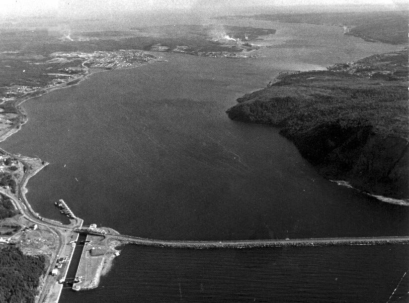
Strait of Canso, looking south towards Chedabucto Bay, with the Canso Causeway and Canal in the foreground. The mainland of Nova Scotia is on the right. (1980) Source
The federal government recognized very early on—at least a decade before the construction of the causeway began in 1952—that it would produce “as yet unknown tidal and environmental effects on the strait.”3
Before the solid rock barrier was constructed, the Canso Strait was a deep and narrow 20km long channel that connected the Gulf of St. Lawrence and the Atlantic Ocean. There was a dynamic two-way tidal flow through the strait where ocean water was flushed and exchanged, and where winter ice could freely move from the lower Gulf through the strait, to Chedabucto Bay and eventually the open ocean. But once the structure impeded the ice and water flows, the deep water south of the causeway became stagnant and ice-free—fjord-like. This ultimately created the ideal conditions for shipping, something that soon attracted a pulp and paper mill, and an oil refinery.4
Meanwhile the northern portion of the Canso Strait accumulated silt and sediment, higher concentrations of pollution, and the build-up of winter ice, which in turn lowered water temperatures, and changed the marine habitat.
The building of the causeway predated both the Fisheries Act, and the Species at Risk Act, which have provisions that deal with habitat, and protect fish passage—subjects we’ll return to later in this series. It also wasn’t until 1973 that the feds would establish an Environmental Assessment and Review Process, so when the causeway was being considered there was no legal requirement to screen the undertaking to ensure the least possible damage to the natural environment. There was also no legal requirement for public consultation.5
This means fishermen, whose livelihoods were affected by how the causeway altered the migratory patterns of commercial fish species, were not consulted.6
Using archival research as well as interviews with fishermen from the Chedabucto Bay area, Lora O’Halloran’s 2018 thesis shows that the Canso Causeway impacted the livelihoods of fishermen on both sides of the causeway. Like the leatherback sea turtle, marine fish also used to travel south from Cape Breton, down the Strait of Canso, and into Chedabucto Bay:
“We never got mackerel in the fall of that year [1955]. It never came through,” said one fisherman. “There used to be haddock and hake, but that was before they built the causeway.”
O’Halloran observed that fishermens’ local environmental knowledge (LEK) about where the fish would be at any given time of year—gained through cumulative place-based observation and experience—was no longer making sense.
O’Halloran writes:
The Canso Causeway brought with it the challenge of anticipating where the fish had gone. To continue making a viable living, harvesters were obligated to invest additional resources toward understanding the shifting conditions of their work and the [Chedabucto] Bay’s marine ecology. But along with shifting livelihood conditions, tight-knit connections to and ideas about place, space, and community were also swept up in the storm of change.
A 2024 study in Marine Ecology, noted a number of migrating fish species that seemed to be affected by the causeway including Atlantic salmon, American eel, and Atlantic saury. Striped bass had to “circumnavigate the entirety of Cape Breton island to exit and enter the Gulf of St. Lawrence.” The study authors also noted that “the change in tidal regimes disrupted the larval transport of American lobster, causing shifts in distribution and a reduction in recruitment,” and that “herring fisheries in the region collapsed.”
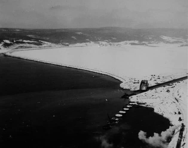
The year after the Canso Causeway was built, there was a shift in the formation and flows of ice through the now blocked Canso Strait. Ice would build up on the north side of the causeway while the south side remained ice-free. Photo: Strait Area Museum, 1956.
Fast forward to late November 2024, when researchers within the Department of Fisheries and Oceans (DFO) became aware that Dina, one of its satellite-tagged leatherback sea turtles, had been trying to exit the increasingly frigid Gulf of St. Lawrence for ten weeks, to return to her Caribbean nesting ground. According to emails obtained through Access to Information (ATIP), staff within the species at risk program (SARP) convened a Teams meeting to discuss Dina’s predicament and noted that the satellite data gathered up to that point indicated she had attempted to exit at St. Georges Bay nine times, but her passage was being blocked by the causeway.
The ATIP indicates that DFO scientists were aware that the causeway also blocks the seasonal migrations of fish and mammals, forcing them all to travel hundreds of kilometres around Cape Breton.
Mike James heads up the sea turtle unit, and it was his team that satellite-tagged Dina in the summer of 2024 and kept staff informed and updated on her whereabouts once he realized she was having trouble exiting the Gulf. He was also the one to eventually deliver the grim news that she was dead and her carcass was floating with the currents in the Laurentian Channel.
At one point, James remarks that “bluefin [tuna] researchers have a receiver there [at the causeway] and they pick up a lot of hits. So bluefin probably used to go through there.”
Branden Lapointe, a DFO fishery officer in conservation and protection (C&P) based in Antigonish points out that the causeway is also blocking the migration of the highly mobile Atlantic saury, an elongated, sharp-beaked fish that travels in schools and moves inshore during the summer and out to deep water later in the year. The species migrates from as far away as Bermuda northward to the Gulf of St. Lawrence and Newfoundland, and back again. They are food for a number of fish higher up in the food chain including tuna and cod.
Lapointe says the saury “get plugged up in the Canso [strait], [along with] thresher shark and LBT [leatherback sea turtle].”
“There’s no lack of info on it—[it’s] natural instinct to go through it,” he says.
Lapointe points to the time in 2014 when a fin whale was found dead by the causeway. The carcass was initially found stuck outside the north gate of the Canso Canal, blocking vessel traffic, according to a news report at the time. To clear the whale, the coast guard decided “to open the north and south gates, allowing the tide to move the carcass through the canal.” According to an examination of the creature, the mammal was still a juvenile, and cause of death was not known.
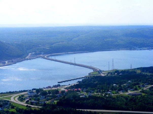
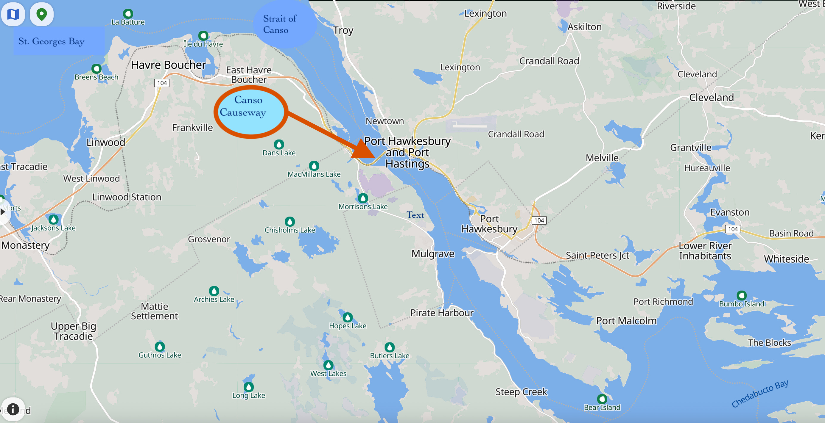
Canso Causeway spans the Strait of Canso, blocking passage between the Gulf of St. Lawrence and St. Georges Bay to Chedabucto Bay and the Atlantic Ocean.
In the last few years the Canso Causeway problem has attracted the attention of five researchers in the biology department at St. Francis Xavier University (StFX) in Antigonish, who noted that there “is little in the literature about the impacts of the causeway on the animals that relied on the strait for movement.”7
They write:
“Now, each year around November there is an annual pulse of biodiversity as fishes such as Atlantic saury and mackerel attempt to enter the strait and get trapped by the causeway. Marine mammals, sharks, and sea birds now also gather here to take advantage of the trapped fish.”
Starting in the fall of 2023, the group began studying the impacts of the barrier on marine animal passage. It’s the first time this kind of study has taken place. By collecting data on temperature, salinity, and plankton composition “before, during, and after the [saury and mackerel] migration on each side of the causeway, the researchers hope to determine factors that are driving the migration.”
They were also planning to do an inventory of species present at each time point.
“We will be collecting historical data to examine changes over time of species present and the timing of migration which is moving later and later every year based on anecdotal evidence,” they write.
I reached out to Heather Penney, the coordinator of the Aquatic Resources Program at StFX, and one of the researchers involved in the Canso Causeway study. In an interview, Penney explains that turtles are not the only animals impacted by the causeway.
“We have seen thresher and blue sharks, sunfish (mola mola), seals, humpback whales, and Atlantic saury, in addition to a lot of birds, but they aren’t affected by the causeway in the same way,” she says.
Penney says the study is still in very early stages and nothing has been published yet.
“Much of the data we do have has been collected from online sources like published papers and iNaturalist sightings,” she explains. “Our next step is to get some funding—I have a couple of grant applications out—in order to really get at what is going on. My guess is this will be 3 or 4 years from now.”
Penney tells me that while the “biggest concern” involving the causeway remains the “direct interactions potentially causing harm or mortality” to species, there is another aspect of harm that is also worrying: namely the “amount of energy that needs to be expended to get around Cape Breton once they find that they cannot get through due to the causeway.”
A case in point would be Hoody, the leatherback found on a beach near Port Hood in November 2024. Recall, the necropsy found he was emaciated and had used up his fat stores, unable to get out of the Gulf soon enough.
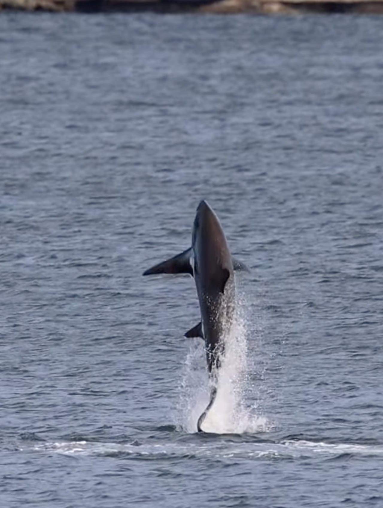
Screen grab of video of thresher shark breaching near Canso Causeway, November 7, 2022. Video posted by Simon d’Entremont to Facebook. D’Entremont notes that the annual migration of Atlantic saury has attracted shark, eagles, a humpback whale, and a leatherback sea turtle.
As previously reported, when Dina was frantically trying to find passage to the open ocean, scientists with SARP—which is responsible for protecting and recovering aquatic species listed under Canada’s Species at Risk Act—were aware that the causeway posed a threat to leatherback sea turtles.
At one point in the email thread, the causeway was referred to as a “death trap.”
During the Teams meeting, Clair Evers, an aquatic science biologist with SARP writes, “There are papers that show the causeway inhibits animal migration and animal passage. We’ve seen tagged animals come up against it in the past where they have not been able to get through. We would like to open up a dialogue around animal passage in that area.”
Indeed, one of those papers Evers might have been referring to was co-authored by her colleague nearly a decade earlier—Mike James.
The 2017 paper appeared in the journal Aquatic Conservation: Marine and Freshwater Ecosystems and focused on entanglements in fixed fishing gear in Atlantic Canada—the leading cause of anthropogenic (human-caused) mortality for sea turtles. By tracking where these entanglements took place over a 16-year period (1998 to 2014), geographic patterns emerged—locations where higher concentrations of turtle entanglements took place—and there was a “conspicuous concentration” of entanglements “in the vicinity of the Canso Causeway.”
The researchers surmised that it could have been a result of a combination of factors. First, there may have been more “fishing effort” (fishing) near the causeway, resulting in more entanglements” or there may have been more turtles there because they were “seeking migratory routes but encountering a barrier (in this case the causeway itself), resulting in periods of increased turtle density in that area.”
The point here is that the causeway’s role in blocking leatherback sea turtle migration—an ancient, hard-wired, evolutionary instinct—was no secret within the government department charged with protecting the species.
The Northwest Atlantic subpopulation of leatherback sea turtles—of which Dina was a valuable member—was designated as endangered in 1981, and legally listed under Canada’s Species at Risk Act (SARA) in 2003. According to a 2022 assessment by the Committee on the Status of Endangered Wildlife in Canada’s (COSEWIC), the species has experienced a “precipitous” decline with the number of known nesting females reduced by 60% over the last 30 years, based on the number of nest sites. For a long-lived species like a sea turtle, 30 years is considered just one generation.
The leading threat to leatherbacks, as previously stated, is bycatch and entanglement in fishing gear, particularly fixed gear and ghost gear, but there are other anthropogenic threats, some of which are more relevant to when they are foraging in Canadian waters and others more applicable to their nesting habitat in the Caribbean. These include underwater noise, marine pollution—including plastics, oil from large-scale spills, and contaminants—coastal and offshore resource development, vessel strikes, poaching of eggs, and nesting habitat decline.8
According to COSEWIC, the “cumulative impact of these threats is large” and many leatherbacks “are simultaneously exposed to multiple threats.”
The population is believed to be “at a high risk of extinction.”9
Once any species is legally listed under SARA in Canada—as the leatherback sea turtle has been—this automatically results in the requirement for a recovery strategy and action plan for the species. The government is also required to report on progress five years after the publication of the final document on the Species at Risk Public Registry, and every subsequent five years following.
The first Recovery Strategy for the species was published in 2007, then came a Recovery Strategy Progress Report 2007-2012, and an Action Plan was finally released in 2020.
It should be noted here that there is no mention of the Canso Causeway blocking the migratory route of leatherbacks in any of these documents.
An amended Recovery Strategy for Leatherback Turtles is currently being prepared and is supposed to provide updated information on the species, threats it faces, and identify critical habitat.
Once critical habitat is identified, it will have to be protected from destruction.10
According to SARA, critical habitat for aquatic species is defined as:
… spawning grounds and nursery, rearing, food supply, migration and any other areas on which aquatic species depend directly or indirectly in order to carry out their life processes, or areas where aquatic species formerly occurred and have the potential to be reintroduced.
This begs the question, will the amended Recovery Strategy define the Canso Strait area—a habitat needed for migration—as critical habitat?
And, while there is ample evidence the Canso Causeway is blocking sea turtle migration, and implicated in indirectly killing some of them, will it be included in the amended Recovery Strategy as a human-caused, or anthropogenic threat?
I reached out to DFO communications to find out the status of the amended Recovery Strategy and they replied that “Targeted consultation and engagements will occur prior to the release of the amended recovery strategy,” but did not provide a timeline for its release.
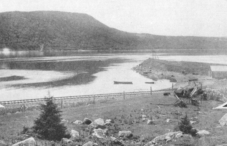
Strait of Canso, unimpeded, 1900. (View from Cape Breton side)
It’s been nearly 20 years since the first recovery strategy for leatherback sea turtles was published and its critical habitat has yet to be mapped. While the reasons for the delay are not entirely clear, what is clear is that some of the studies needed to determine critical habitat, which were outlined back in 2007, have yet to be completed. According to DFO’s recovery strategy progress report, at the time the recovery strategy was published, the studies informing critical habitat were expected to be completed within five years. While some of them have been completed, others are “still in progress.”
An unreasonable delay in mapping critical habitat—the first step in getting that habitat protected—is the subject of a recent lawsuit led by Ecojustice. The environmental law charity is taking the federal government to court over an eleven year delay in the mapping of critical habitat for the Southern Mountain caribou, which were listed as endangered for more than 20 years. As stated, mapping critical habitat is a legal requirement under SARA and according to Ecojustice lawyer Sean Nixon, by taking so long to map critical habitat, the federal government is not only “undermining the purposes of the Act, namely the protection and recovery of Canada’s threatened wildlife,” but is “causing serious harm” to the species.
To find out more about what kind of bearing this law suit could have in the case of leatherbacks, or other endangered species, I reached out to Mike Kofahl, a staff lawyer with East Coast Environmental Law (ECELAW).
“This is a huge issue with species at risk legislation generally, including federal but also provincial acts because one of the key steps is to identify habitat and then for that to be protected. So, it would certainly set a precedent if that [Ecojustice] litigation was successful and it could have ramifications for other species that have never had any of that activity begun.”
Kofahl says that while there is ongoing work to identify critical habitat for leatherbacks, “how much time do you allow to pass before you have to say, ‘well, we need something’?” But he also notes that the pressure to designate critical habitat may or may not be meaningful “with respect to the Canso Causeway.
“I don’t know if [the causeway] would be designated as part of its critical habitat,” he says.
But according to Penney, it should be. An important part of any recovery strategy is identifying the critical habitat and “areas where individuals would be at risk.” Penney says the causeway is one of those areas.
“Endangered species need to be protected from those risks.”

Heather Penney is the coordinator of the Aquatic Resources Program at St. Francis Xavier University, and one of the researchers involved in the Canso Causeway study. Penney also co-authored a 2025 study that appeared in Marine Ecology, that looked at “underappreciated threats” to connectivity for fish within the marine environment, including causeways. In it, the Canso Causeway was included as a “notable” example of how infilling the ocean environment to create a road can be highly damaging to marine connectivity. Other examples cited were located in the Florida Keys, the Johor-Singapore Causeway linking Singapore to Malaysia, and the King Fahd Causeway linking Saudi Arabia to Bahrain.
Penney points to the efforts made for the North Atlantic right whales, which are highly susceptible to vessel strikes because they rest, feed, and socialize near the ocean surface. In an attempt to protect the roughly 380 right whales that remain, mandatory measures in critical habitats involving shipping lanes and fishing areas have been enforced.
Recall, according to the ATIP, a number of DFO scientists are also on board to get the ball rolling.
“Pretty convinced it [the causeway] is definitely an issue for turtle passage,” says James. “Blocked since 1952 but in generation time of LBT [leatherback sea turtle] this is nothing. Back then there were no habitat provisions.”
Senior fisheries protection biologist, Colleen Smith, says the species at risk program has to start documenting it and get it into the recovery plans.
DFO biologists Heidi Schaefer and Katherine Hastings discuss the potential of using eDNA to measure the presence of leatherbacks near the causeway, “if washing up dead on beaches isn’t enough.”
They all seem to agree that it’s time to acknowledge the problem, and fix it.
[Stay tuned for Part 5. It will be posted sometime in mid-April. Thank you for your patience.]
In Canso Strait, the word “Canso” is believed to be derived from the Mi’kmaq word gamso’q, which means “opposite the lofty cliffs.” Ironically, the lofty cliffs of Porcupine Mountain were blasted for the granite that would create the causeway, that would block the strait.
But despite the promises to the contrary, in the short term the causeway resulted in a massive economic disruption in the Strait of Canso area, resulting in a “flurry of out-migration” especially in the Mulgrave and Point Tupper areas. As well, while Macdonald touted the benefits that would accrue to Cape Breton’s coal and steel industry by allowing better access to bigger markets, the reality was that these industries received bulk shipments, and shipped the vast majority of their product by water, via Sydney and Louisburg—something that continued even after the causeway was constructed. For more on the history of the causeway construction and the aftermath I would highly recommend Lora O’Halloran’s 2018 Masters’ thesis titled “The Political Ecology of the Canso Causeway: Development, Marine Harvesting, and Competing Notions of Progress.” (Dalhousie University), as well as “The Canso Causeway: Tartan Tourism, Industrial Development, and the Promise of Progress for Cape Breton,” by Meaghan Beaton (Trent University) and Del Muise (Carleton University).
According to this study, in 1943 a Special Committee of the House of Commons, charged with (among other things) studying the possibilities of a fixed link between Cape Breton and the mainland of Nova Scotia, heard testimony from Department of Transport staff, D.W. MacLachlan. “McLachlan concentrated on what sort of permanent link would be most appropriate: a bridge, a causeway, or a tunnel. He testified that the cost of either a tunnel or bridge, estimated at $8,000,000 and $22,000,000 respectively, might prove excessive, and that either might encounter severe weather problems posed by strong tides and unpredictable ice conditions. Construction of a causeway, on the other hand, at an estimated $10,000,000, presented few of the risks posed by a bridge or tunnel, although it would produce as yet unknown tidal and environmental effects on the strait.”
However, another study completed in 1949 by a trio of engineers—the Canso Board of Engineers Committee—concluded that a low-level bridge was the way to go and in the same year the feds and province jointly announced an agreement to start construction under a tri-party agreement between the federal Department of Transport, Nova Scotia Department of Highways and the Canadian National Railway. Funding was provided by the feds to provide a fixed link between mainland Nova Scotia and Cape Breton Island to replace a marine ferry crossing between the villages of Mulgrave and Port Hawkesbury, and Mulgrave and Point Tupper.
But the low-level bridge plan would end up being abandoned as a result of the width of road required by the new Trans-Canada Highway standards. The board of engineers was then reconvened and they recommended that a causeway be built instead. I haven’t seen the engineers’ original report, but they seemed to conclude that a bridge was in fact feasible despite the tides and ice flow, which to this day are often cited for the reasons why a bridge spanning the strait was deemed not feasible.
Also interesting to note that the granite needed for the construction of the causeway itself was sold to the provincial Liberal government by Alister Fraser, a sitting Liberal MLA who happened to own Porcupine Mountain. According to Lora Ohalloran, Fraser “eventually sued the Province for payment of the materials, arguing that he had not been fairly compensated. This led to a Supreme Court case (Fraser v. The Queen, 1963) where it was decided that the Province would pay Fraser the market value of the materials.”
Industries attracted to the new ice-free harbour included Stora Enso, a pulp and paper mill (currently Port Hawkesbury Paper), Gulf Oil, a refinery (currently EverWind Fuels), and a heavy water plant. One unforeseen consequence of the causeway was that it would create a port at Point Tupper that could accommodate the world’s largest oil tankers. In 1970, one of them—the Liberian-registered tanker SS Arrow—carrying oil from Venezuela, would run aground in high winds on Cerberus Rock in Chedabucto Bay and sink, along with spilling half of its cargo of Bunker ‘C’ oil, approximately 2.5 million gallons (8,125 metric tonnes). Then, just nine years later, the Kurdistan, on its way from Point Tupper to Sept Isles, Quebec, would split in two in the Cabot Strait area and spill another 7,500 tonnes (roughly 2 million gallons). A little known fact about these spills is that the oily debris collected in clean-up efforts of the heavily contaminated shoreline—more than 800 km in the case of the Kurdistan spill—was buried in 18 disposal sites – four in Cape Breton County, nine in Richmond County and five in Guysborough County. A study about the land based disposal of the oil from the Kurdistan was accessed through FOI and can be found here.
While there were no legal requirements to mitigate harm to migrating species by providing passage, the Navigation Act required that ship traffic through the Strait of Canso could not be impeded by the structure, so the Canso Canal was built on the causeway’s eastern end, with a swing bridge. The building of the canal was very separate from the building of the causeway. Originally, the canal was not part of the Canso Strait – it was part of Balhache Point on Cape Breton Island, though it had to be widened into the strait using cellular cofferdam and straight wall pilings. The canal bed was blasted down deep enough that commercial ships could enter. Concrete was poured and anchored to the solid rock. Once completed, water was allowed in. See here.
Lack of consultation with fishermen prior to the causeway construction is reported in Judy Peitzsche’s study, “The Canso Causeway and its Effects on its Surrounding Areas,” which she wrote as a student intern with the Guysborough County Inshore Fishermen’s Association. The study also provides data showing number of fishermen per county before and after the causeway, and lobster landings (1945-1965).
The poster was presented at the Society for Canadian Aquatic Sciences conference in early 2024.
From Recovery Strategy (2006): “There are a range of sources of anthropogenic noise in the marine waters of Atlantic Canada that produce underwater sounds within the frequency range detectable by sea turtles. These include oil and gas exploration [ie. seismic airguns] and development, shipping, fishing, military activity, underwater detonations, and shore based activities… Concerning the exposure to seismic airguns used in exploration, studies to date describe behavioural responses such as; increased swimming speed, increased activity, change in swimming direction and avoidance…startle responses and erratic swimming behaviour…a temporary reduction in hearing capability and temporarily increased physiological parameters (e.g., glucose, white blood cells and creatinine phosphokinase) which is suggestive of damaged tissues or altered physiology.”
This “will be accomplished through a SARA Critical Habitat Order made under subsections 58(4) and (5), which will invoke the prohibition in subsection 58(1) against the destruction of the identified critical habitat.” Under SARA, critical habitat must be legally protected within 180 days of being identified in a final recovery strategy or action plan.
No posts
Comments
Nothing yet. Say the first thing.
Sign in to join the conversation.