
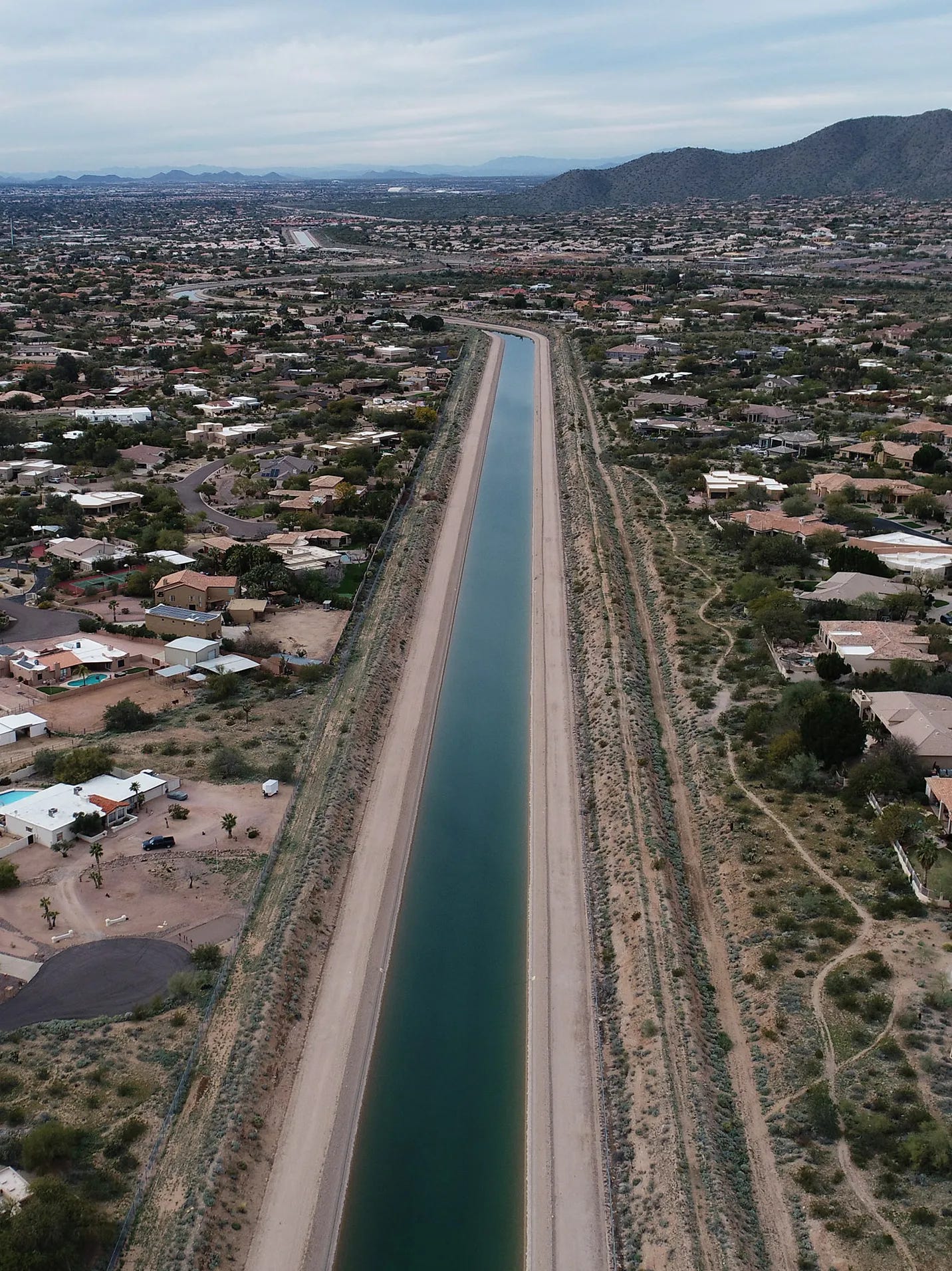
Arizona’s most important river — the long canal delivering Colorado River water to Phoenix and Tucson.
Phoenix, Arizona, is a remarkable story of human engineering—a desert oasis created by water projects, air conditioning, and explosive growth. It is also a city now approaching a crisis because of those same three forces. This week, the Department of the Interior released a proposed plan for managing the Colorado River over the next decade. It could require Arizona, California, and Nevada to reduce their combined use by as much as three million acre-feet a year, with Arizona likely to bear the deepest cuts. At almost the same moment, Phoenix endured another extraordinary heat wave, reaching 117 degrees on July 24. Arizona’s water supply, already scarce, is likely to shrink dramatically as the heat becomes more intense.
The aptly named Valley of the Sun sprawls across roughly 3,000 square miles of the broad desert basin surrounding Phoenix. It occupies the metropolitan heart of Maricopa County, although the county itself extends far beyond the Valley. Maricopa County now has nearly 4.7 million residents, including approximately 1.67 million within the City of Phoenix. The region lies near the northern edge of the Sonoran Desert and receives an average of only about seven inches of rain each year. That limited precipitation arrives in two principal seasons: winter storms from the Pacific and highly localized monsoon thunderstorms during July, August, and September. The summers are extraordinarily hot. Under the current thirty-year climate average, Phoenix experiences 111 days each year when the temperature reaches or exceeds 100 degrees.
Both of my parents were born in the Valley of the Sun during the early years of the Great Depression, and I have always felt a kinship with the region. As a child, I often spent several weeks each summer with my paternal grandmother at her house at 1326 East Brill Street, not far from what is now downtown Phoenix. My younger brothers and I struggled with the heat during those visits in the 1960s.
My grandmother’s house had a single large evaporative cooler. Water flowed across three thick pads of straw-like material while a powerful fan pulled hot, dry outside air through them. As the water evaporated, the phase change from liquid to vapor absorbed heat from the passing air and sent somewhat cooler air into the house. On the driest summer days, the system worked reasonably well. But its cooling capacity was limited, and as the temperature climbed above 100 degrees, the house still became oppressively warm.
My brothers and I would sometimes escape by walking to a nearby Bob’s Big Boy. There, in the luxury of refrigerated air, we would stretch a lunch of modest-quality hamburgers over several hours before finally making the hot walk back to our grandmother’s house.
Even as a teenager, I wondered why anyone would choose to make a permanent home in such heat. Yet the unusual geography of central Arizona has made the Phoenix Valley a magnet for human settlement for nearly two thousand years. The Valley is a vast alluvial basin crossed by rivers carrying water from mountains that are much cooler and wetter than the desert below. For millennia, floods from the Salt, Verde, and Gila Rivers spread layers of sand, silt, and clay across the basin, creating broad expanses of fertile soil. The desert offered little rain, but it possessed rich farmland—provided someone could bring the rivers to it.
More than two thousand years ago, Hohokam farmers and water engineers began doing precisely that. The Hohokam—the archaeological name for the forebears of today’s O’odham peoples—built their greatest canal systems along the Salt and Gila Rivers. The Salt flowed through the center of the Phoenix Valley; the Verde joined it along the northeastern edge of the basin; and the Gila passed south of Phoenix before receiving the Salt west of the modern city. Together, these rivers carried water from the mountains and springs of the Arizona high country and southwestern New Mexico into the Sonoran Desert.
Hohokam irrigated agriculture was established in the Salt River Valley more than two thousand years ago, but the great expansion of the canal system began between approximately A.D. 600 and 700. Over succeeding centuries, generations of workers excavated, enlarged, cleaned, repaired, and sometimes abandoned and replaced hundreds of canals. The largest main channels were engineering works of astonishing scale—some more than ten feet deep and thirty feet wide—and individual canals extended for many miles across the nearly level desert floor
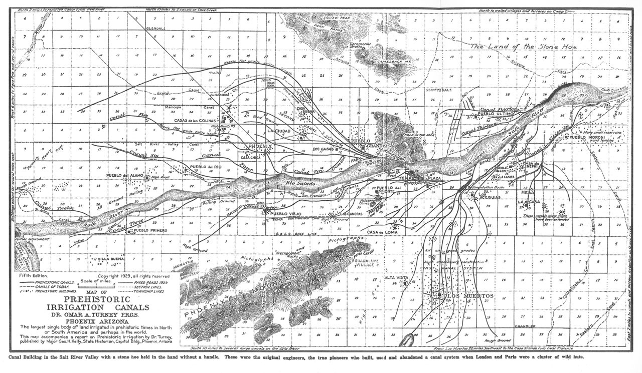
.Omar Turney’s 1929 map of the Hohokam canal system in the Salt River Valley — the map is more of less centered on the location of modern day Phoenix.
At the height of Hohokam society, the combined network contained hundreds of miles of canals—more than 700 miles across the Salt and Gila river valleys—and is thought to have irrigated more than 100,000 acres. It was the largest and most complex irrigation system known in pre-European North America and the most extensive in the New World north of Peru. Its fields produced corn, beans, squash, cotton, and tobacco, supplemented by native foods such as mesquite beans, cactus fruit, and agave. The canals sustained large villages and a settled agricultural society in one of the hottest and driest landscapes on the continent.
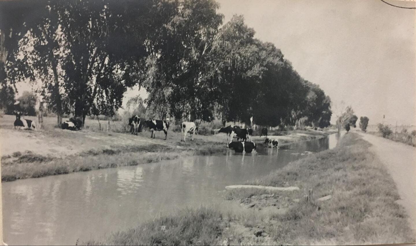
A 1912 photograph of a repurposed Hohokam cannel - the Salt River flows through the Valley of the Sun bringing life to the desert.
The Hohokam model became the blueprint for the modern Phoenix Valley. When my parents were born, Phoenix had fewer than 50,000 residents. That modest population had long depended upon the Salt River—a free-flowing but unreliable river capable of both devastating floods and near disappearance during drought. Farmers in the Valley understood that canals alone could not provide security. They advocated for a large dam in the mountains that could capture floodwater, store spring runoff, and release the river gradually when crops required it.
The Salt River Project became one of the first five projects authorized under the Reclamation Act of 1902, which established a federal role in financing and constructing waterworks across the arid West. In 1911, Roosevelt Dam was completed in a narrow canyon about 75 miles upstream from Phoenix. The original dam rose 280 feet and stretched 723 feet across the canyon. Behind it, Roosevelt Lake could store approximately 1.3 million acre-feet of water.
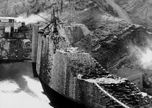
Construction of the Roosevelt dam — it was a masonry design, unlike the modern solid concrete structures of today. November 1, 1909.
Both the dam and the lake were engineering marvels of their day. Roosevelt Dam was then the highest masonry dam in the world, and Roosevelt Lake was the world’s largest artificial lake. The project could not create more water, but it did alter the timing of the river’s flow. Floods and mountain snowmelt could be captured and held until farmers and cities needed them. Roosevelt Dam allowed Phoenix to bloom—and cemented the conviction that water engineering was the future of the Valley of the Sun.
My grandmother’s house had belonged to her father, my great-grandfather. It stood only about three miles north of the Salt River channel, which was no longer a normally flowing river by the time my father was born. Yet my great-grandfather owned a citrus orchard supplied by Salt River water carried through the Valley’s canals. The river had not disappeared; it had been removed from its natural channel, placed under human control, and made to flow through fields instead.
During the first few decades of the twentieth century, the water stored behind Roosevelt Dam sustained the economy of the Valley of the Sun. The state’s principal industries were known as the “five Cs”: copper, cotton, cattle, citrus, and climate. The land surrounding Phoenix was covered by cotton fields, citrus groves—including my great-grandfather’s—and alfalfa farms. World War II began the transformation of Phoenix from an agricultural center into an industrial city. Luke Field, Williams Field, Falcon Field, and other military installations brought tens of thousands of service members and civilian workers into central Arizona. Small industries appeared to support the bases, while federal spending expanded roads, airports, utilities, and the regional economy. When the war ended, many veterans who had trained in Arizona returned with their families. Manufacturers followed, attracted by inexpensive land, a growing labor force, and the promise of almost unlimited room for expansion. Agriculture did not disappear, but it ceased to be the principal engine of the Valley’s economy. Phoenix grew from approximately 107,000 residents in 1950 to 439,000 in 1960 and nearly 582,000 by 1970—a fivefold increase in only twenty years.
Two forces were especially important in facilitating Phoenix’s growth: air conditioning and urban sprawl. Although air conditioning existed before World War II, residential units were expensive and generally installed only in the most costly homes. After the war, mass production lowered their price, and during the 1950s refrigerated air spread rapidly across the American Southwest. It fundamentally changed the meaning of summer in Phoenix. People no longer had to organize their houses and working hours around the heat. Windows could be sealed, factories could operate through the afternoon, and families arriving from cooler parts of the country could live much as they had before—provided the electricity continued to flow.
Air conditioning was not the sole cause of Phoenix’s growth. Cheap land was another essential ingredient. But refrigerated air removed the most immediate physiological barrier to living in the desert. Subdivisions spread rapidly across former farmland, and the compact agricultural city began evolving into the immense metropolitan region that occupies the Valley today.
The transformation created a new kind of dependence. Roosevelt Dam and the Salt River Project had supplied farms and a comparatively small city. They had not been designed for a metropolitan region of millions of people, nor could the Salt and Verde Rivers be expected to support limitless growth. As new homes, industries, and cities spread across the desert, wells were drilled more deeply and groundwater was pumped faster than nature could replace it. Arizona once again confronted the basic facts of the desert: its ambitions were growing more rapidly than its dependable water supply.
Arizona therefore turned toward the Colorado River. The river did not naturally pass through Phoenix or Tucson. It flowed along the state’s western boundary, carrying snowmelt from the Rocky Mountains toward Mexico. Bringing that water into central Arizona would require one of the most audacious water projects ever undertaken in the American West: an artificial river flowing uphill across the desert.
The Central Arizona Project was authorized by Congress in 1968, after decades of political struggle over Arizona’s share of the Colorado River. Construction began at Lake Havasu in 1973. The completed system would consist of 336 miles of canals, tunnels, pipelines, reservoirs, and pumping stations. Its enormous pumps would lift Colorado River water nearly 3,000 vertical feet before gravity carried it through central Arizona and south toward Tucson. CAP water reached metropolitan Phoenix in November 1985, and the main aqueduct system was substantially completed in 1993.
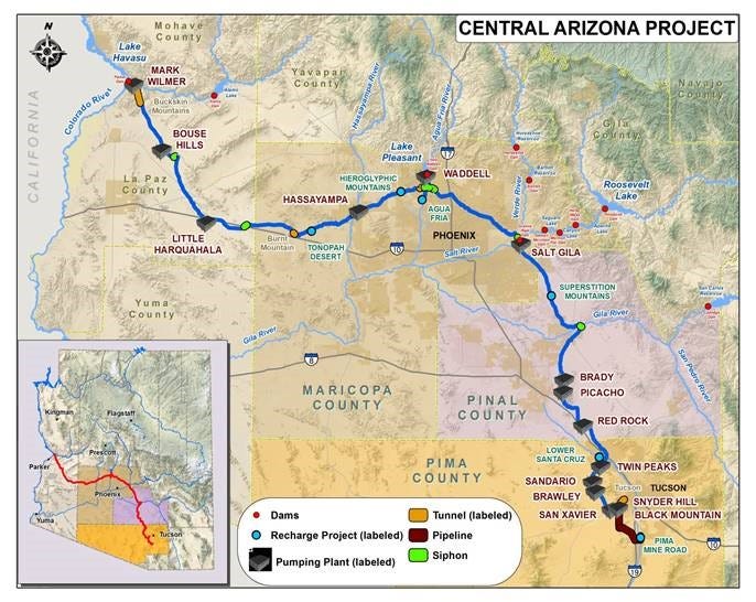
The Central Arizona Project was an extraordinary engineering achievement. It reinforced the lesson Phoenix believed it had learned from Roosevelt Dam: when the desert presented a limit, technology could provide a way to modify that limit. Air conditioning made the Valley seem cooler than it was. The CAP made the Valley seem wetter than it was. Together, they allowed Phoenix to grow on a scale that would once have been unimaginable. They also made the modern city dependent upon two vast and uninterrupted flows—Colorado River water and electrical power—neither of which can now be taken for granted.
The way Arizona uses the water flowing through canals and stored behind dams—along with the precious groundwater beneath the desert—reveals the depth of the state’s water crisis. Arizona currently uses roughly seven million acre-feet of water in a typical year, approximately 2.3 trillion gallons. Despite the state’s explosive population growth, that total is slightly lower than it was during the late 1950s, largely because farmland within and surrounding the cities has been converted to less water-intensive urban development and because farms, industries, and municipal water systems have become more efficient. Yet the statewide total conceals a striking imbalance in who uses the water.
Approximately 72 percent of Arizona’s water—about five million acre-feet in an average year—is used by irrigated agriculture. Municipal use accounts for roughly 20 to 22 percent, or approximately 1.4 to 1.5 million acre-feet. The remaining 6 to 7 percent is classified as industrial use. The industrial category is broader than manufacturing alone: it includes mines, electric-generating plants, dairies and feedlots, large cooling facilities, golf courses, and other enterprises that hold their own water rights or pump directly from wells. Manufacturing therefore consumes only a portion of Arizona’s comparatively small industrial share.
The municipal category is broader than household use. It includes water delivered by municipal systems to homes, businesses, restaurants, schools, hospitals, parks, and many industrial facilities. Most municipal water is nevertheless associated with residential use, and Arizona estimates average municipal consumption at approximately 146 gallons per resident each day. In summer, a large fraction of household water is used outdoors for lawns, landscaping, swimming pools, and other purposes.
These numbers highlight one of the most persistent misconceptions surrounding Arizona’s water crisis. Residential conservation clearly matters. Desert landscaping, efficient appliances, repaired leaks, reduced evaporation, and wastewater reuse can save substantial amounts of water. Phoenix and other Arizona cities have already demonstrated that municipal water use per person can fall even as their populations grow. But the statewide water shortage cannot be solved principally by asking residents to take shorter showers or remove another patch of grass.
Simply put, Arizona—and therefore Phoenix—faces a water crisis because agriculture occupies too much of the state’s water ledger.
Irrigated agriculture is the foundation upon which modern Arizona was built, and it remains economically and culturally important to many rural communities and tribal nations. Arizona farmers have also invested heavily in drip irrigation, laser-leveled fields, lined canals, improved scheduling, and other conservation measures. Agricultural water use has fallen from nearly 90 percent of the state total in earlier decades to approximately 72 percent today.
Nevertheless, a hotter and drier Arizona cannot continue using roughly five million acre-feet of water each year for agriculture without asking difficult questions about what is grown, where it is grown, and what water source sustains it. Some crops provide far greater economic or nutritional value per gallon than others. Some are grown in places where renewable river water is available; others depend upon groundwater accumulated over centuries or millennia. Improving irrigation efficiency alone may not solve the problem, because water saved on one field can be used to irrigate additional acreage rather than returned to the aquifer or river.
Ultimately, Arizona—and Phoenix—must address the water crisis in the realm of politics. Arizona’s political leaders have understood the problem for decades. They have debated solutions repeatedly, commissioned studies, created task forces, and proposed new groundwater laws. Yet the state has often responded to the approaching limits of its water supply by searching for another engineering miracle rather than confronting the much more difficult question of consumption.
This is the birthplace of water magic: the hope that the federal government will finance a vast desalination plant on the Gulf of California and pump fresh water hundreds of miles into Arizona; the belief that another canal, pipeline, reservoir, or groundwater-transfer project will permit growth to continue unchanged; or the assumption that the Colorado River will somehow recover the flows it carried during the unusually wet twentieth century. Climate change makes that final assumption particularly indefensible. A hotter atmosphere increases evaporation, reduces snowpack, and diminishes the fraction of precipitation that reaches the river. Arizona cannot base its future on the expectation that the Colorado will simply become larger again.
The deeper political failure lies beneath the ground. Groundwater supplies approximately 41 percent of all the water used in Arizona—roughly 2.8 million acre-feet in a typical year. Within the Phoenix, Tucson, Prescott, and other Active Management Areas, pumping is measured and subject to varying degrees of regulation. The Central Arizona Project, artificial recharge, declining agricultural acreage, and the 1980 Groundwater Management Act have slowed or reversed groundwater losses in parts of metropolitan Phoenix.
Outside these regulated areas, however, Arizona law has historically imposed remarkably few limits. A landowner may generally pump groundwater for any “reasonable and beneficial use,” even when that pumping lowers neighboring wells or depletes an aquifer that took centuries to fill. Outside an Active Management Area or Irrigation Non-Expansion Area, the Arizona Department of Water Resources ordinarily has no authority to stop one landowner from damaging another through groundwater withdrawal. The rule is effectively first come, deepest well.
The consequences are now measurable. In the Gila Bend Basin, monitored groundwater levels declined at a median rate of approximately three feet per year between 2000 and 2020. In the Willcox Basin, some areas have experienced as much as 400 feet of drawdown since 1940, while annual groundwater overdraft exceeds 100,000 acre-feet. In the Ranegras Plain of western Arizona, one monitored well has fallen more than 240 feet since the 1980s. Wells fail, the land subsides, fissures open across roads and farms, and the aquifer itself is permanently compressed.
There is no single statewide rate at which Arizona’s water table is falling. Some aquifers are relatively stable; others are retreating by several feet each year. That variation should not obscure the statewide reality. Arizona is withdrawing groundwater faster than nature replaces it in many of its most important agricultural basins. Groundwater is being treated not as renewable income but as inherited capital—and the state is rapidly spending the inheritance.
The politics of groundwater are difficult because the benefits of pumping are immediate and concentrated, while the costs are delayed and widely distributed. A farmer gains another crop, an investment company gains another tract of irrigated land, and a developer gains another subdivision. The dry domestic well, collapsing aquifer, and damaged road appear years later, often on someone else’s property. Every participant therefore has an incentive to pump before regulation arrives.
Arizona has spent nearly half a century demonstrating that groundwater regulation can work within its major metropolitan areas. Its continuing failure has been its unwillingness to extend meaningful protection to much of rural Arizona. The state does not lack scientific understanding or engineering skill. It lacks the political willingness to say that some uses must shrink, some crops should not be grown in particular basins, and some forms of growth cannot continue simply because investors demand them.
Arizona—and especially the Valley of the Sun—is a crystal-clear case study in why adaptation to climate change is so difficult. Adaptation requires immediate political action to prevent economic and ecological damage that may unfold over decades. It requires government to regulate private behavior, enforce limits, spend public money, and ask some citizens and industries to sacrifice benefits they enjoy today for a future they may never personally see.
None of those qualities is abundant in the American Southwest. The region’s political culture has long celebrated growth, private property, individual freedom, and resistance to government authority. Yet water does not respect property lines, county boundaries, or political ideology. An aquifer pumped beneath one farm lowers the wells of its neighbors. A subdivision approved today commits water that may not exist fifty years from now. A crop planted for immediate profit can consume groundwater accumulated over thousands of years.
Climate adaptation therefore demands precisely what Arizona politics has been least willing to provide: restraint. It requires the state to acknowledge that engineering cannot manufacture water, that efficiency cannot accommodate unlimited growth, and that some activities—some crops, some developments, and perhaps some visions of the future—can no longer be sustained. The physical crisis is increasingly clear. The unresolved question is whether Arizona’s political institutions can act before nature imposes its own, far harsher solution.
No posts
Comments
Nothing yet. Say the first thing.
Sign in to join the conversation.