
Today carries the more serious threat, an enhanced risk across the Upper Midwest and Great Lakes with a corridor from Iowa through Wisconsin into Upper Michigan where a couple of strong tornadoes (EF2 or greater) are possible. Tomorrow’s picture is still forming, pattern recognition points at the Ohio Valley with a damaging wind threat, but I’m not ready to hang numbers on it yet.
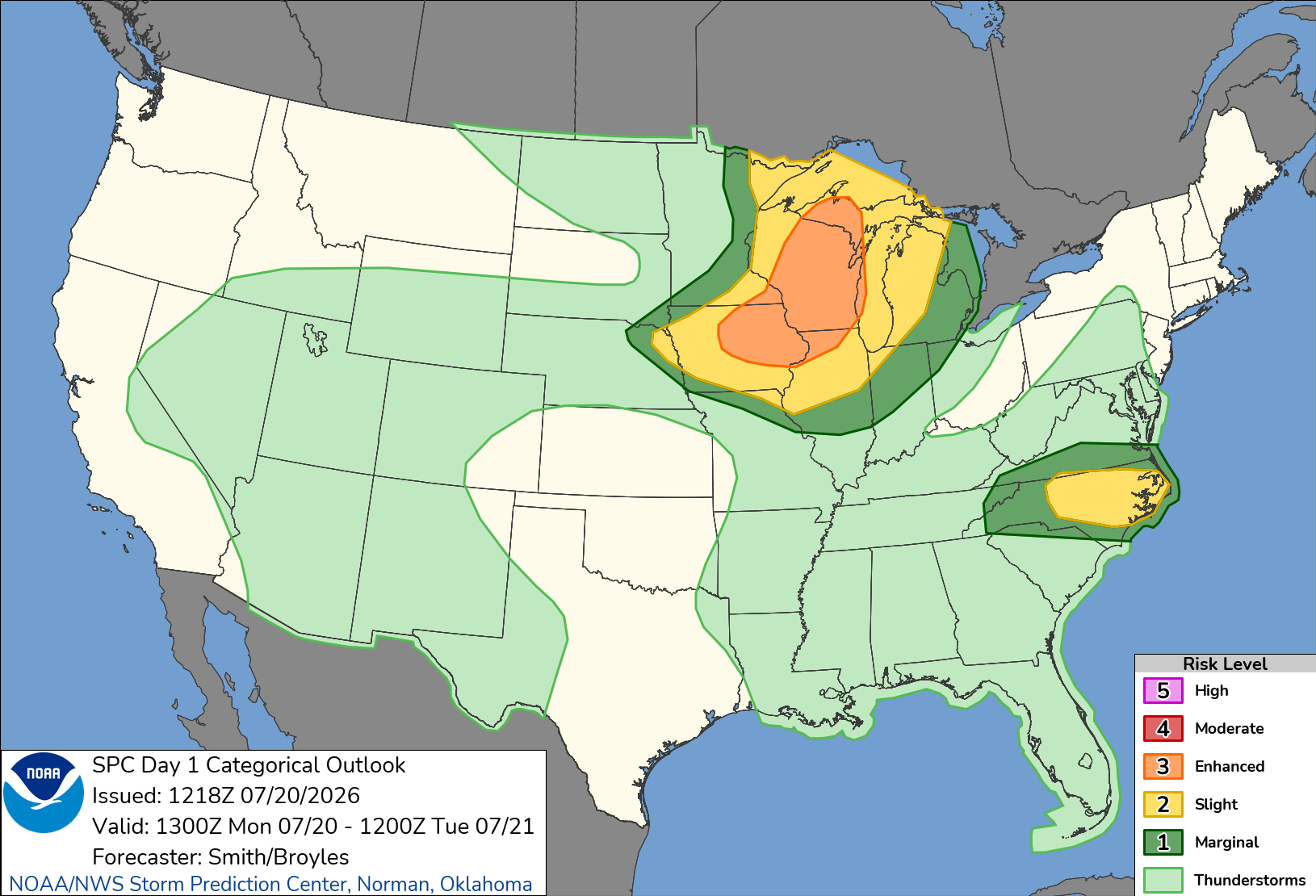
Synoptic setup: A substantial shortwave trough currently sitting over southern Manitoba is amplifying and sliding southeast toward the Lake Superior vicinity through tonight. Riding with it is a strengthening belt of west-northwesterly flow aloft, 50 to 70 knots at mid levels and a genuinely impressive 100 knots in the upper levels over Minnesota and Wisconsin. Ahead of that trough, a plume of steep mid-level lapse rates is advecting east-southeast into a warm sector holding dewpoints from the upper 60s into the lower and middle 70s. That combination of strong deep-layer shear and real instability is the setup that turns ordinary thunderstorms into supercells.
Timing: Early day storms are possible this morning across southeast Minnesota into western Wisconsin and eastern Iowa, riding elevated instability with effective shear over 50 knots, capable of hail and some strong gusts. That activity should wane through the day, opening a possible lull before more organized development kicks off by late afternoon along the cold front as it tracks toward Wisconsin, Upper Michigan, and northern and eastern Iowa. Storms should evolve into clusters through the evening, with the damaging wind and tornado threat persisting southeastward before intensity finally fades overnight.
Threats and storm mode: Initial cells today should be dominated by supercells given the strength of the deep-layer shear, with a corridor of large hail and tornado risk running east of the instability axis, from Iowa across Wisconsin into Upper Michigan. As the evening progresses, expect transition toward clusters, at which point the wind threat becomes more widespread even as some tornado risk lingers.
The strong-tornado question: This is the part worth slowing down for. Effective storm-relative helicity, a measure of the spin available to a storm’s inflow, may exceed 300 square meters per second squared across Wisconsin into Upper Michigan, supported by seasonally very strong winds in the 2 to 3 kilometer layer above ground (700 mb winds over 50 knots). That’s the kind of low-level spin that lets a supercell tighten and produce a strong, potentially long-track tornado rather than a brief spin-up. Forecasters note tornado probabilities could still be raised in later updates once this morning’s convective debris and its effect on afternoon heating gets resolved. Near-surface winds may veer some with time, which would work against the tornado threat, but the SRH numbers involved are high enough that the strong-tornado potential looks real regardless.
Elsewhere today, the Carolinas and far southern Virginia sit under a slight risk this afternoon as a moist airmass destabilizes south of a west-east front. MLCAPE over 2000 J/kg and precipitable water above 2 inches, paired with modest westerly flow aloft, points toward multicellular storms and isolated damaging gusts through sunset. And offshore, Tropical Depression Two is expected to gradually strengthen over the northeastern Gulf today and tonight, though current guidance keeps supercell-related tornado potential low given the system’s overall weakness and light winds aloft.
Confidence and what could change: Pattern confidence for today is high, this setup produces severe weather. Placement confidence within the Iowa to Upper Michigan corridor is good but not locked, and the biggest lever to watch is how much early morning convection and its cloud debris limit afternoon heating. Less heating means less instability to work with, which could shift or shrink the tornado corridor. Watch for SPC to adjust tornado probabilities through the day as that resolves.
For Tuesday, I’m working from Saturday’s medium range guidance rather than a fresh Day 2 outlook, so treat this as a lower confidence read. That guidance has an upper trough pivoting across the Ohio Valley into the Mid-Atlantic Tuesday and Wednesday, with a surface cold front sweeping through by Wednesday night.
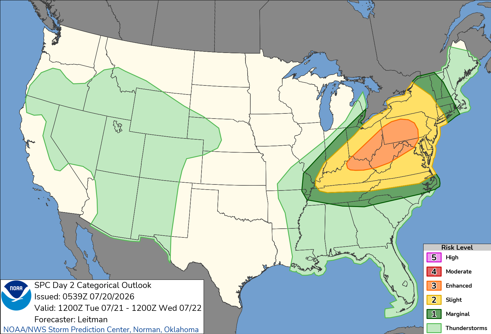
Convection may already be ongoing Tuesday morning across Illinois, Indiana, lower Michigan, and western Ohio, and the downstream airmass looks favorable for scattered severe storms Tuesday afternoon and evening, likely organized into one or more line segments ahead of the front. Damaging wind is the pattern-suggested headline threat. I’ll have a sharper read once SPC’s actual Day 2 product updates.
Thanks for reading Simply, Weather.! This post is public so feel free to share it.
No posts
Comments
Nothing yet. Say the first thing.
Sign in to join the conversation.