
This week I was startled at 1:42 AM by the MyShake app on my phone. A 4.6 earthquake occurred Southeast of Boulder Creek California and the message was drop cover and hold on. I did exactly that and waited but where I am in Oakland some 65 miles away, I didn’t feel anything and after a few minutes I crawled out from under my desk and hopped on the USGS site to find out what happened. It was enough of a wake up call to keep me up half the night. I started to wonder about what would happen if the big one, I mean the really big one, the Cascadia one happened. Would I be prepared? Would anyone be prepared?
If you work in tech, operations, project management, or any field that depends on digital infrastructure consider this is your briefing. Not because disaster is certain, but because the risk is real, the science is clear, and the conversation almost never reaches the people who need to understand it.
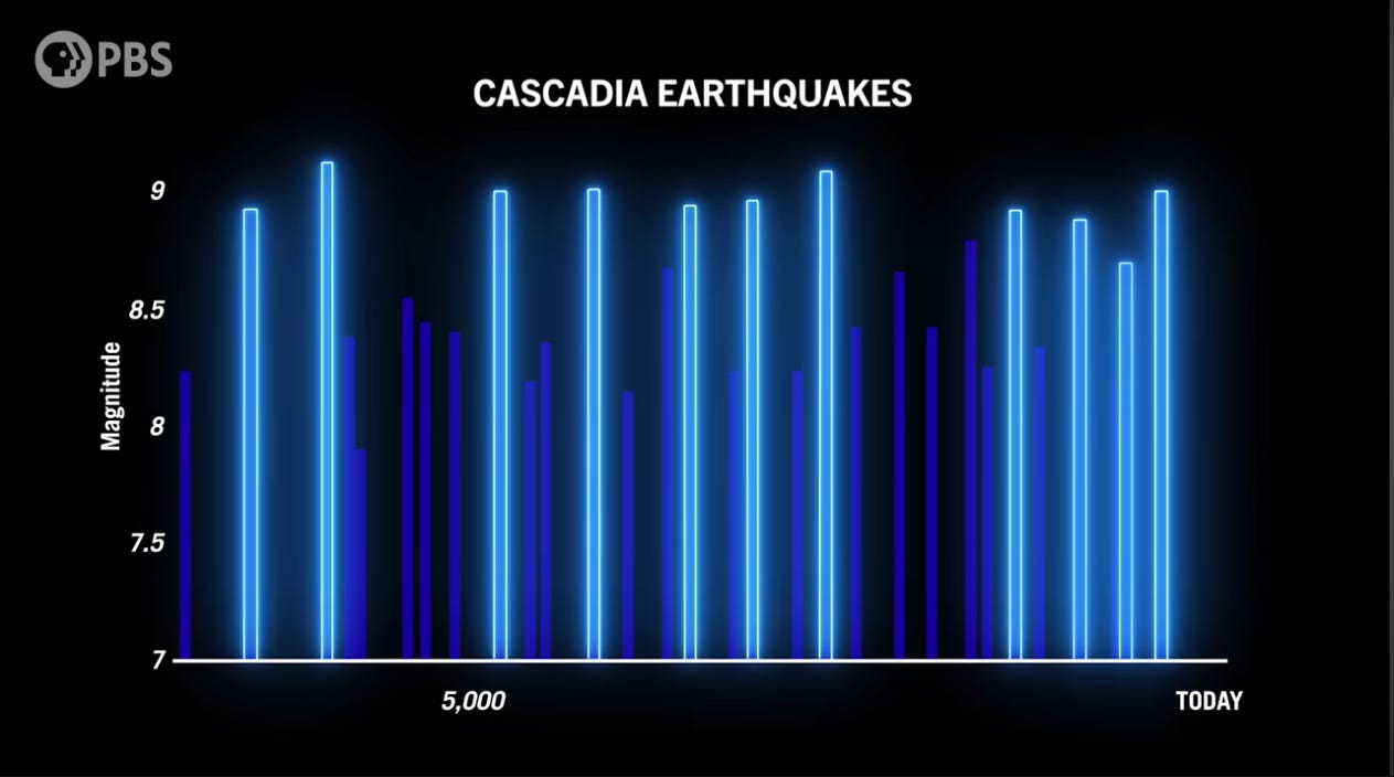
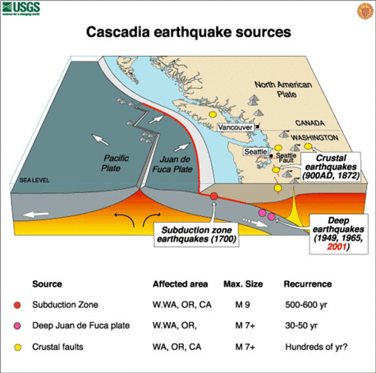
On January 26, 1700, at approximately nine-thirty in the evening, a 700 mile long fault line off the coast of the Pacific Northwest ruptured. The earthquake estimated at magnitude 9.0 shook the ground for four to six minutes across a territory stretching from what is now northern California to British Columbia. The Cascadia Subduction Zone is a megathrust fault stretching several hundred miles from Vancouver Island, Canada to Northern California. It dropped the coastline by as much as six feet in minutes, turning dry ground into tidal mudflats. It generated a tsunami that crossed the Pacific Ocean and struck the coast of Japan the following morning, where it was recorded in their historic annals as an Minashigo or ‘orphan tsunami’ because it arrived without a locally observed earthquake to explain it. We know the exact date not because anyone in North America wrote it down, but because the Japanese did.
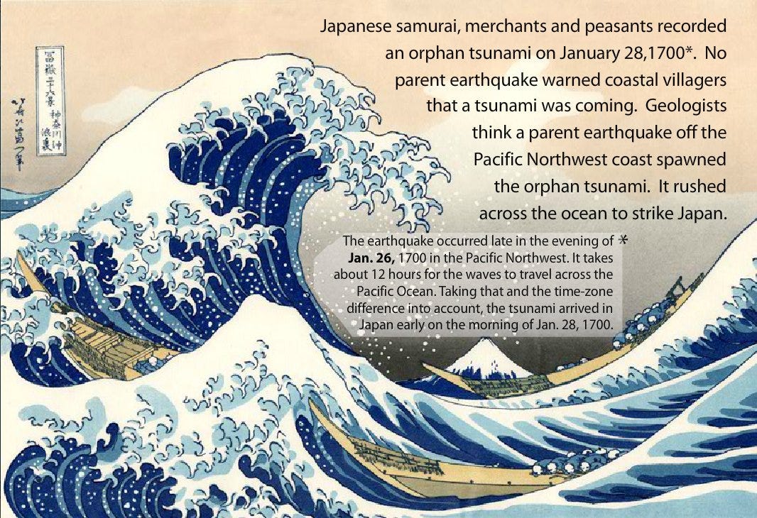
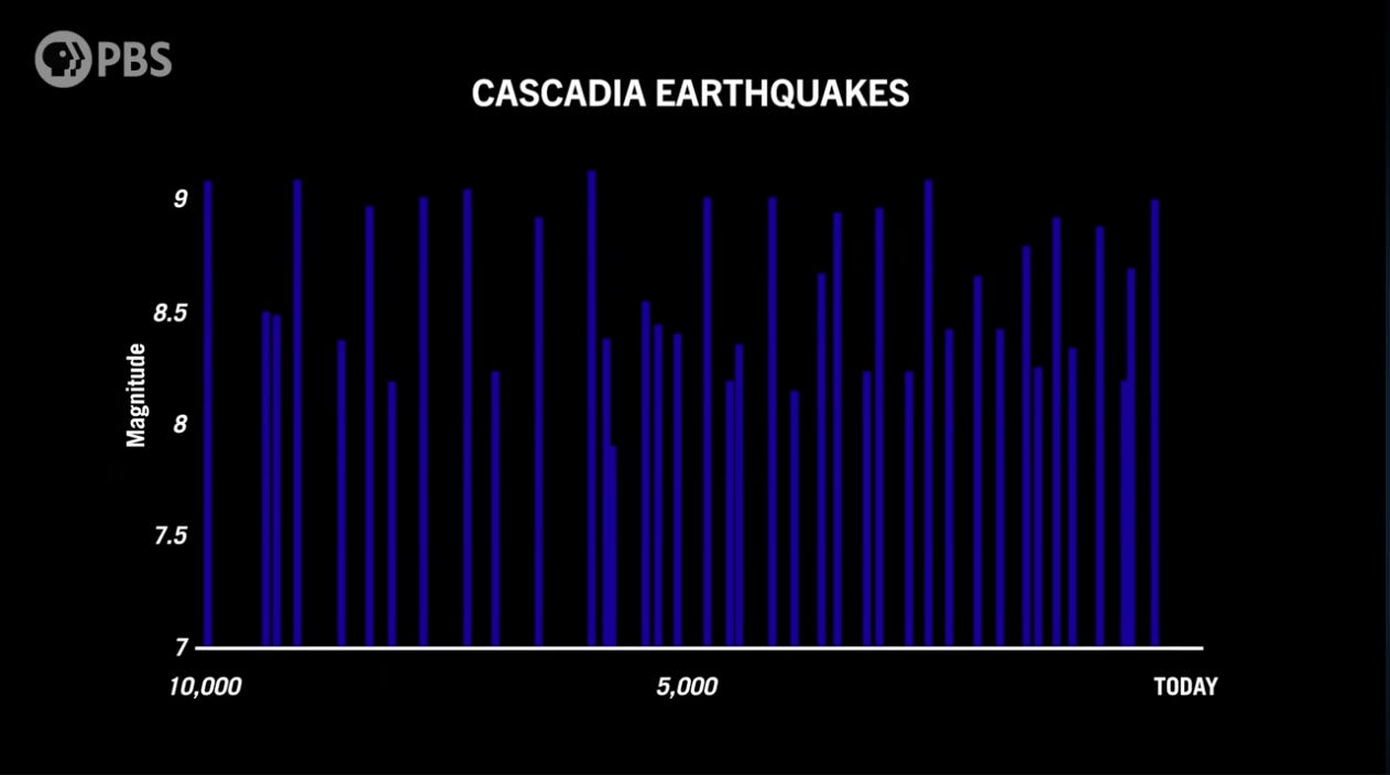
That happened 326 years ago. The Cascadia Subduction Zone has been silent ever since building pressure, storing the slow accumulation of tectonic energy that will eventually, inevitably, be released. The geologic record shows that in the past ten thousand years, the fault has produced 43 major earthquakes. The average time between each megathrust earthquake is approximately 240 years. So we are 86 years overdue by that measure. The Cascadia clock has been running for three centuries and it does not care about our infrastructure.
This article is not intended to alarm. It is intended to inform because the conversation about Cascadia almost never reaches the communities and industries that depend most heavily on the infrastructure sitting directly above, below and beside this fault zone. The technology sector, our data economy, the internet and the AI industry are at risk. This is an honest look at what the science tells us, what a major seismic event on the Cascadia Subduction Zone would mean for the digital world we live and work in and what thoughtful leaders in technology can do about it now.
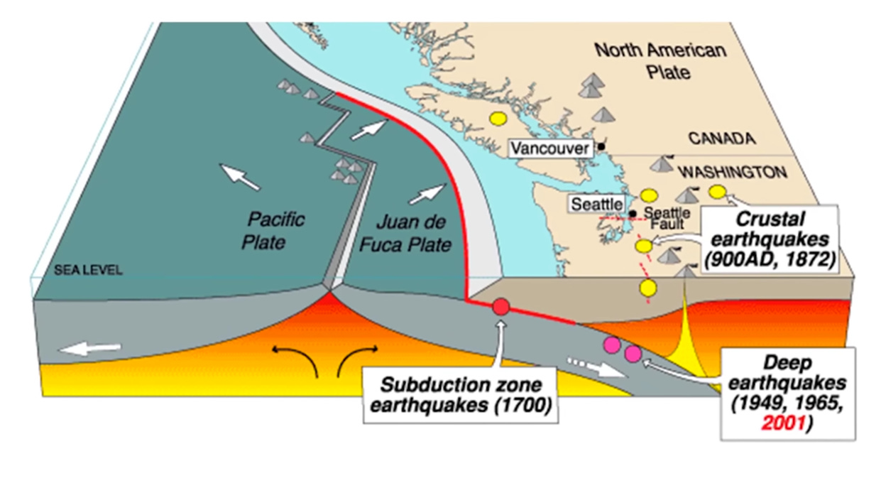
Again, the Cascadia Subduction Zone is a 700-mile megathrust fault that runs offshore along the Pacific coast from Cape Mendocino in northern California north to Vancouver Island in British Columbia. It marks the boundary where the Juan de Fuca plate is being forced beneath or subducted under the North American plate at a rate of approximately four centimeters per year. At depths shallower than about thirty kilometers, the two plates are locked together by friction. The strain they accumulate does not release gradually it builds silently and then releases all at once, catastrophically.
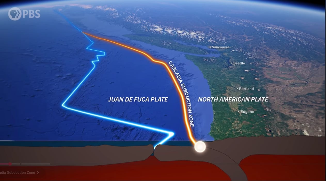
Subduction zone megathrust faults are the only faults on Earth capable of producing earthquakes greater than magnitude 8.5. The Cascadia Subduction Zone has a well-documented history of magnitude 9.0 or greater events. The 2011 Tohoku earthquake in Japan, the 2004 Indian Ocean earthquake are Cascadia’s geological cousins. When geophysicists first proposed in the 1980s that Cascadia was capable of such events, they were met with skepticism. But by the 1990s, the geologic detective work was complete. The fault had not merely produced great earthquakes in the past. It had done so repeatedly, with devastating consequences, and it will happen again.
The probabilities are compelling, because they are often either overstated in popular media or quietly dismissed by people who find them inconvenient to think about.
There is a 37 to 43 percent chance of a magnitude 8.0 to 8.6 southern margin rupture in the next 50 years, according to USGS estimates.
There is a 10 to 15 percent chance of a full-margin magnitude 9.0 rupture affecting the entire coast from northern California to British Columbia within that same timeframe.
An 85 percent chance exists that by 2060, the fault will have exceeded the recurrence interval of 85 percent of its historical earthquakes, based on analysis of 6,000 years of seismic records.
The last full-margin rupture produced shaking that lasted four to six minutes. For context, the 1906 San Francisco earthquake lasted approximately 45 to 60 seconds.
FEMA estimates that a magnitude 9.0 earthquake on the Cascadia fault would kill approximately 14,000 people in Oregon and Washington alone, displace over 27,000 from their homes, and cause economic losses in Oregon exceeding 32 billion dollars. These projections do not include California, British Columbia, or the effects of a potential triggered San Andreas event a scenario we will examine shortly.
The consequences of a Cascadia rupture extend well beyond the initial shaking. When the fault releases, the North American plate will rebound and the land that has been bowing upward under tectonic compression for hundreds of years will rapidly subside, dropping by as much as one to two meters along the coast. Dry ground will become tidal mudflat. Ports, towns, roads, and infrastructure built on what is now stable ground will find themselves permanently at or below sea level.
New research from Virginia Tech geoscientist Tina Dura, published in the Proceedings of the National Academy of Sciences, found that a Cascadia earthquake today would expand coastal floodplains by approximately 300 square kilometers immediately, tripling the number of structures exposed to regular flooding. Combined with sea level rise, that number could reach 370 square kilometers by 2100. The land does not return to its previous elevation. The flooding is permanent and those communities are not temporarily displaced, they will be geologically relocated.
The tsunami arrives on coastal areas of Oregon, Washington, and northern California within fifteen to thirty minutes of the earthquake. Wave heights along the open coast are projected at thirty to forty feet in many locations, reaching up to one hundred feet in focused bays and river mouths. Coastal populations will have almost no warning time. Oregon’s Emergency Management department is explicit: communities west of the tsunami inundation zone will be without external services and assistance for at least two weeks, if not longer.
For decades, geologists treated the Cascadia Subduction Zone and California’s San Andreas Fault as two separate systems though geologically proximate, but functionally independent. That assumption has been upended by research published in October 2025 in the journal Geosphere, led by Oregon State University marine geologist Chris Goldfinger and his team of researchers who analyzed 137 sediment cores representing 3,100 years of seismic history from both fault systems.
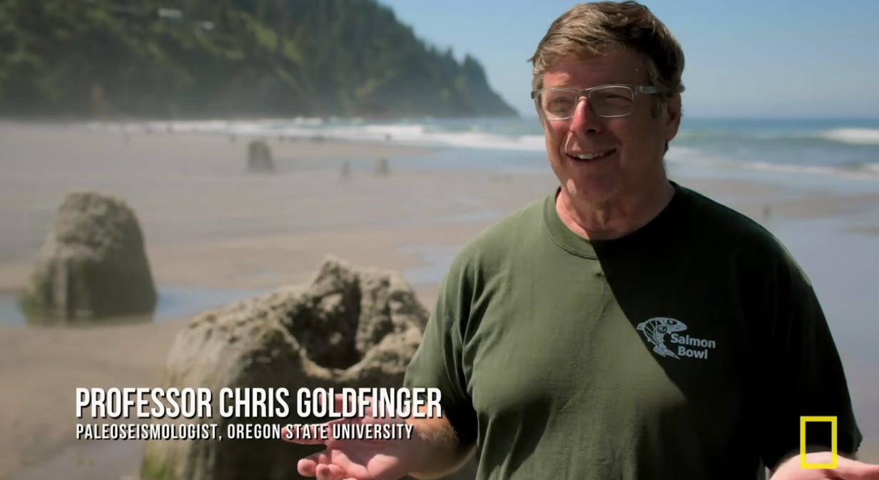
Their findings are sobering because the two fault systems appear to be partially synchronized. In the sediment record, multiple Cascadia earthquakes are followed within hours to decades by corresponding earthquakes along the northern San Andreas Fault. Of the fifteen San Andreas earthquakes identified in the record over a 3,000-year period, thirteen occurred at nearly the same time as earthquakes on the southern Cascadia Subduction Zone. The Cascadia earthquakes consistently preceded the San Andreas events, suggesting that a major Cascadia rupture may transfer stress southward along the coast, loading the San Andreas toward its own failure.
If I were in my hometown of Palo Alto and Cascadia went off, I think I would drive east. There looks to me like a very high risk the San Andreas would go off next. It is kind of hard to exaggerate what a magnitude 9 earthquake would be like in the Pacific Northwest. And so the possibility that a San Andreas earthquake would follow it is movie territory. Chris Goldfinger, Oregon State University
Goldfinger and his colleagues are direct about the implications in that a single major Cascadia earthquake would, all on its own, draw down the emergency response resources of the entire United States. FEMA’s 2019 National Threat and Hazard Identification and Risk Assessment examined exactly this scenario and estimated response times alone at over four months, with recovery measured in years.
If both occurred first Cascadia followed by a major San Andreas rupture, whether within hours, days, or years would place Seattle, Portland, Vancouver, San Francisco, and the Bay Area all in states of simultaneous emergency. No country on Earth has the response or resource capacity for a disaster of that scale affecting that many major cities in that kind of compressed timeframe.
It is important to note what the science does and does not say. Some San Andreas earthquakes, including the 1906 event, occurred independently of Cascadia. The timing intervals between any dual events range from hours to decades. This is not a prediction that both faults will rupture simultaneously. However, there is evidence that the risk of a sequential dual event is significantly higher than previously assumed and that hazard planning for the West Coast must account for that possibility.
The main thing about Cascadia is that we have essentially no level of preparation for this sort of thing. Japan is very well prepared and actually did quite well in their earthquake. But our situation is we’ve built all our major cities (you know, Vancouver, Seattle, Portland, Victoria) on Cascadia, not having any idea that this problem existed. Chris Goldfinger Oregon State University
Here is what most technology professionals working in this sector do not fully appreciate: the Pacific Northwest is one of the largest internet infrastructure hubs in the United States. It hosts major data centers for cloud providers, research networks, colocation facilities, and critically, the landing points for submarine cables that carry approximately 47 percent of international internet traffic connecting the United States to Asia and beyond.
47% of US-Asia international internet traffic passes through submarine cable landing stations sitting directly in the Cascadia tsunami inundation zone.
Research from the University of Oregon’s ShakeNet project, which developed a framework to assess the resilience of internet infrastructure in the Pacific Northwest to seismic forces, produced findings that should be required reading for every tech leader with infrastructure in the region. Their assessment is that approximately 65 percent of fiber links and cell towers between Portland and Seattle are susceptible to very strong to violent earthquake shaking in the next 50 years. The Seattle-Tacoma-Bellevue and Portland-Vancouver-Hillsboro metropolitan areas which are two of the densest concentrations of internet infrastructure on the West Coast will have a 10 percent chance of incurring severe earthquake shaking within the same period.
A Cascadia event would not simply knock out internet service in Portland and Seattle. The cascading failure would propagate through layers of interdependent infrastructure in ways that are difficult to fully model but important to understand:
Submarine cable landing stations on the Oregon and Washington coasts would be directly exposed to tsunami inundation and ground subsidence, potentially severing the trans-Pacific cable connections that carry nearly half of all US-Asia internet traffic.
Fiber-optic cable runs that follow highway and rail corridors where many would cross liquefaction-prone soils and bridge structures rated for far lower seismic loads than a magnitude 9 event would experience widespread breaks across hundreds of miles.
Cell towers, the majority of which are not seismically rated for extreme ground acceleration, would fail across the region at precisely the moment emergency communications are most critical.
Power grid infrastructure, transmission lines, substations, and generation facilities would sustain significant damage, and Washington County emergency planners estimate electricity could be offline for one to three months following a major Cascadia event.
Water and sewer systems serving data center cooling infrastructure are projected to be offline for one month to one year. Data centers without independent water supply cannot operate cooling systems for extended periods.
Telecommunications systems more broadly are expected to experience major disruptions and the Oregon Resilience Plan lists telecommunications disruption as a primary consequence alongside water, power, and highway damage.
The technology industry has spent the past several years building an AI infrastructure that is both enormously powerful and structurally concentrated. The training clusters, inference infrastructure, and cloud services that power the AI economy depend on physical data centers, physical power supply, physical cooling systems, and physical network connectivity. They also depend on the humans who operate them and those humans live somewhere.
A Cascadia event would not merely degrade AI service availability in the Pacific Northwest. It would stress the entire North American AI infrastructure by removing a significant portion of the compute, network, and human capacity that the system depends on, at exactly the moment when AI-assisted emergency response, communications coordination, and logistics optimization would be most urgently needed. The point being that the infrastructure needed to help manage a catastrophic disaster would itself be among the casualties of that disaster.
If a synchronized San Andreas event followed, the situation would extend into the Bay Area which is the home to the headquarters and significant infrastructure of virtually every major AI company in the world. The concentration of AI capability in a geographically seismically active corridor is not a theoretical concern. It is a structural vulnerability that the industry has not seriously confronted.
The submarine cable figure deserves its own discussion. Approximately 47 percent of international internet traffic connecting the US to Asia-Pacific passes through landing stations on the Pacific Northwest coast. These stations are physical buildings where undersea cables come ashore and connect to terrestrial networks and they are located in the areas most exposed to tsunami inundation and land subsidence following a Cascadia rupture.
The global internet does not have a clean failover for the loss of nearly half its trans-Pacific capacity. Traffic would reroute eventually, but with significant latency and capacity constraints. Financial markets would be severely disrupted. Supply chains, logistics and communication systems that connect North America to Asian markets would be degraded for months, potentially years, while cable infrastructure was repaired and rebuilt.
Emergency managers in Oregon and Washington are clear-eyed about what a Cascadia event will require: communities need to be self-sufficient for a minimum of two weeks, and coastal communities may be isolated for far longer. County emergency management directors describe the event not as an ‘if’ but as an absolute ‘when.’ The preparedness infrastructure being built by state and local governments — seismic retrofitting, early warning systems, evacuation planning — is serious, sustained, and deeply underfunded relative to the scale of the risk.
The technology sector, by contrast, has largely treated Cascadia as someone else’s problem. Disaster recovery planning in most tech companies focus on power outages, cyberattacks, or localized hardware failures. The scenario of a weeks-long regional infrastructure blackout affecting a 700-mile stretch of the Pacific Coast, simultaneously disrupting power, water, communications, transportation, and personnel availability, is simply not in most business continuity playbooks but know what we know now it should be.
The most immediate structural response available to technology organizations is geographic diversification of critical systems positioned away from the Cascadia impact zone. This does not mean abandoning the Pacific Northwest but it does mean ensuring that no single critical capability exists only within the earthquake and tsunami hazard zone. So data centers, cable stations, and the human teams that operate them should have genuine geographic redundancy and not the paper redundancy of two facilities both sitting on the same seismic fault.
This is not an abstract exercise. The ShakeNet research team explicitly noted that a dramatic reduction in earthquake-induced infrastructure damage is achievable through thoughtful routing restructuring in order to significantly reduced seismic exposure. The technology exists and the economic case is straightforward. What is missing is the organizational will to prioritize catastrophic risk alongside the short-duration operational risks.
The ShakeAlert Earthquake Early Warning System, which covers Oregon, Washington, and California, received a significant upgrade in 2024 with the addition of GPS-based sensors capable of detecting the magnitude 8 and 9 events the Pacific Northwest is actually at risk for. University of Oregon earthquake scientist Diego Melgar, who helped develop the GPS technology, describes it as a meaningful advance that will give people, systems, and infrastructure potentially seconds to minutes of warning before the most violent shaking happens.
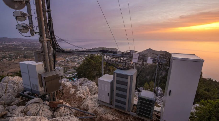
A mobile phone base station located on a mountain near the ocean. New research at the UO finds that internet and communications infrastructure could be wiped out in a Cascadia earthquake.
For technology infrastructure, those seconds and minutes matter. Automated shutdown and initiated controlled power-down sequences can help reduce the risk of fire and hardware damage. Organizations in the hazard zone should be integrating ShakeAlert triggers into their operations technology, not treating it as a consumer-facing alert system with no enterprise relevance.
Infrastructure resilience planning in technology typically focuses on systems, servers, cables, power supplies but it almost never adequately addresses the human continuity problem: what happens to the engineers, operators, and decision-makers who live in the impact zone when that zone becomes uninhabitable or inaccessible for weeks or months?
Oregon’s emergency management guidelines estimate that communities in the Cascadia impact zone should plan for a minimum of two weeks without external services. For technology teams whose members live in Portland, Seattle, or the surrounding areas, this means planning for a workforce that may be simultaneously dealing with personal displacement, family safety, and the absence of the basic utilities that remote work requires. The organizations that will recover most quickly from a Cascadia event will be those that have thought carefully about this human dimension of disaster resilience, not just the systems dimension.
For practitioners whose professional lives are organized around Agile principles, the Cascadia preparedness challenge maps cleanly onto familiar frameworks. Iterative risk assessment. Cross-functional team resilience. Retrospective learning from near-misses and historical events. Continuous improvement of systems under uncertainty. The discipline of planning for disruption rather than assuming stability.
The Agile Manifesto’s emphasis on responding to change over following a plan was written for software delivery. But rigid, plan-dependent systems fail under uncertainty, and adaptive, resilient ones survive. This also applies with equal force to infrastructure, to organizations, and to the communities technology companies serve. A fault zone does not negotiate with your roadmap. It does not wait for your next sprint. The organizations that will serve their users, employees, and communities best when the ground moves are the ones building adaptive resilience now, not the ones assuming continuity.
There is a concept in risk management called a ‘known unknown’ — a risk we are aware of but cannot precisely quantify or schedule for. The Cascadia Subduction Zone is perhaps the most consequential known unknown in North American infrastructure planning. We know the fault exists. We know it ruptures. We know roughly how often, how large, and how destructive those ruptures are. We know that our infrastructure sits directly in its path. We just don’t know when. That uncertainty is frequently used as an excuse for inaction. The 63 percent chance it will not happen in the next 50 years is treated as permission to defer it. But consider that by 2060, there is an 85 percent chance the fault go. The clock is not running in our favor. The longer the interval, the larger the accumulated strain and the larger the eventual release.
The technology industry has built genuinely extraordinary things around one of the most seismiclly dangerous fault systems on Earth. The submarine cables, data centers, cloud infrastructure, and AI systems that the global economy now depends on are concentrated in a zone whose geologic history and destiny is already written. But the potential for utter catastrophe is not a given. This is a solvable engineering and organizational problem if the conversation starts now, while there is still time to act. The science is real and the clock is ticking. Will we be ready when the ground moves?
I’d like to hear from those of you in technology, operations, and infrastructure: Is Cascadia in your business continuity planning? Are you building geographic redundancy into your systems? I’m particularly interested in what practitioners are actually doing about this.
Please feel free to drop a comment below. Share this with a colleague in the Pacific Northwest. And if you want to go deeper, the key takeaways and sources at the bottom of this article are peer-reviewed, government-sourced, and sobering.
The Cascadia Subduction Zone last ruptured in 1700. We are already 86 years past its average recurrence interval. Scientists estimate a 37 to 43 percent chance of a major rupture in the next 50 years.
Ground shaking in a full-margin Cascadia rupture would last four to six minutes across a 700-mile zone, accompanied by land subsidence of up to two meters and tsunami waves reaching 30 to 100 feet along the coast.
New 2025 research from Oregon State University’s Chris Goldfinger provides compelling evidence that Cascadia and the northern San Andreas Fault are seismically synchronized — a major Cascadia event may trigger a corresponding San Andreas earthquake, placing Portland, Seattle, Vancouver, and the San Francisco Bay Area in simultaneous crisis.
Approximately 65 percent of fiber links and cell towers between Portland and Seattle are at risk of severe damage in a major seismic event. Approximately 47 percent of US-Asia international internet traffic passes through submarine cable landing stations directly in the Cascadia tsunami inundation zone.
Power, water, telecommunications, and highway infrastructure in the Pacific Northwest may be offline for weeks to over a year following a major Cascadia event — timescales that current technology disaster recovery planning is not designed to address.
AI infrastructure is disproportionately concentrated in seismically active corridors. A Cascadia event, potentially followed by a San Andreas event, would stress global AI infrastructure at the exact moment when AI-assisted emergency response would be most needed.
Practical responses available to technology organizations include geographic diversification of critical infrastructure, integration of ShakeAlert early warning triggers into operations technology, and genuine human continuity planning for a multi-week regional blackout scenario.
Goldfinger, C. et al. (2025). Unravelling the dance of earthquakes: Evidence of partial synchronization of the northern San Andreas fault and Cascadia megathrust. Geosphere. DOI: 10.1130/ges02857.1
Dura, T. et al. (2025). Dual threats of Cascadia earthquake and sea-level rise on Pacific Northwest coast flooding. Proceedings of the National Academy of Sciences. Virginia Tech.
Mayer, J., Sahakian, V., et al. (2021). On the Resilience of Internet Infrastructures in Pacific Northwest to Earthquakes (ShakeNet). Passive and Active Measurement. Springer. University of Oregon.
USGS. (2025). Earthquake probabilities and hazards in the U.S. Pacific Northwest. U.S. Geological Survey Fact Sheet 2025-3050.
FEMA. (2019). National Threat and Hazard Identification and Risk Assessment (THIRA): Cascadia Subduction Zone M9.0 earthquake and triggered San Andreas scenario.
Oregon Department of Emergency Management. Cascadia Subduction Zone preparedness resources. oregon.gov/oem/hazardsprep
Melgar, D. et al. (2024). GPS-enhanced ShakeAlert earthquake early warning system for Pacific Northwest. USGS / University of Oregon.
Video listing
Tsunami Escape Washington’s Uphill Battle
The Cascadia Megaquake Is Inevitable. And It Will Reshape America Forever
Wait...The Worst Possible US Disaster Just Got EVEN WORSE?!? (Cascadia Megaquake)
#ProjectManagement #OperationsManagement #DisasterRecovery #BusinessContinuity #Infrastructure
No posts
Comments
Nothing yet. Say the first thing.
Sign in to join the conversation.