
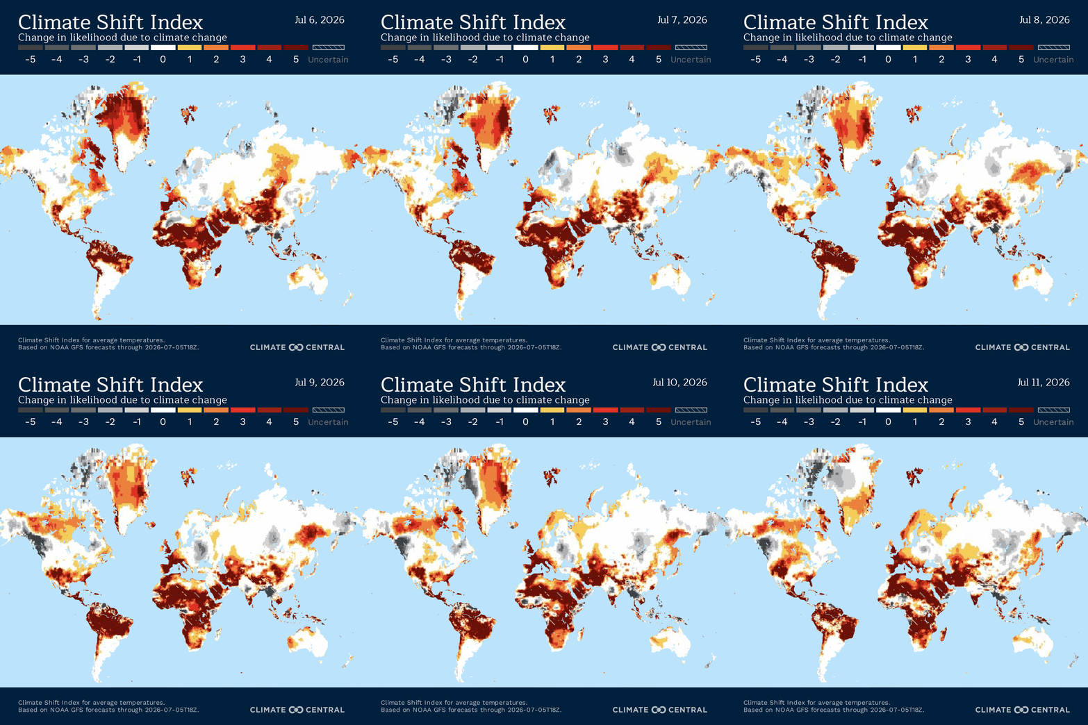
Unusual heat across several regions is overlapping with climate-linked risks to land, water, health, ecosystems, public finances, and cultural identity. In Hawai‘i, the Lāhainā fires show how hotter, drier conditions interacted with long-running changes to land, water, vegetation, and Native Hawaiian ties to ‘āina. In Kiribati, rising seas and warming ocean waters are threatening football fields, national visibility, tuna revenue, and household food security. In southern India, heat is affecting informal outdoor workers and app-based delivery workers who often have limited control over when they can stop, rest, or cool down. In Sri Lanka, changing wetland conditions could make flamingo habitat harder to sustain, while in India’s mountain regions, warmer winters, unusual rainfall, and longer warm periods are helping mosquito-borne diseases spread into places where they were previously less common.1
Need to read this in a language other than English? Try OpenL (up to 1,500 characters) or Google Translate—both offer free translations into 100+ languages.
Climate change and rapid urbanization fuel deadly floods across West Africa, exposing rising resource pressures— West Africa is enduring one of its most destructive rainy seasons in decades. Last week, catastrophic flooding hit parts of Ghana, Côte d’Ivoire, Benin, and Togo, killing dozens of people, displacing thousands, and leaving major roads and neighborhoods underwater. Ghana was among the hardest hit, where more than 140 mm (5.51”) of rain fell within a 24-hour period, making for the country’s highest single-day rainfall total in more than 30 years. Entire neighborhoods in the capital, Accra, were inundated as roads disappeared beneath floodwaters and residents swam through neck-deep water to rescue trapped neighbors. At least 13 people were killed, hundreds were rescued, and more than 38,000 people were directly affected by the flooding. In neighboring Côte d’Ivoire, weeks of relentless rainfall have killed dozens of people since the start of the rainy season in April, while Benin’s capital, Cotonou, recorded approximately 141 mm (5.55”) of rainfall, leaving major roads underwater and transportation systems immobilized. Residents in Togo also reported repeated flooding that has forced some families to abandon their homes entirely. The floods come as coastal West Africa faces increasingly intense rainfall and fast-growing cities with limited drainage capacity. For every 1°C (1.8°F) increase in global temperature, the atmosphere can hold approximately 7% more moisture, amplifying the intensity of heavy rainfall and turning seasonal downpours into destructive flash floods. These impacts are further compounded by rapid urbanization, inadequate drainage infrastructure, blocked waterways, informal settlements, and construction within floodplains, all of which reduce cities’ capacity to absorb and safely channel floodwaters. Home to more than five million residents, Accra is one of Africa’s fastest-growing metropolitan areas, with an annual population increase of more than 2%. But the city’s population has grown faster than drainage and other basic infrastructure. Poor drainage, clogged gutters, informal housing, and development along waterways have reduced the city’s ability to absorb and move stormwater during heavy rain. Following the disaster, President John Mahama ordered the demolition of structures built within waterways and authorized the immediate release of $29 million for emergency relief. Police, firefighters, military personnel, and the National Disaster Management Organization (NADMO) were deployed to rescue stranded residents, clear blocked drainage channels, and protect critical infrastructure. The Ghana National Fire Service rescued more than 470 people, while the floods also sparked a major fire at a rubber factory, further compounding the emergency.
Beyond the immediate destruction, more frequent and intense rainfall is reshaping Ghana’s ecosystems and livelihoods. Floodwaters accelerate soil erosion, stripping away fertile topsoil and degrading agricultural land, while rivers increasingly fluctuate between destructive flooding during the rainy season and prolonged low flows during droughts, making freshwater supplies less reliable for communities and farming. These disruptions threaten one of Ghana’s most important economic sectors, as more than 45% of the country’s workforce relies on rain-fed agriculture. Floods destroy crops, delay planting, damage transportation networks, and worsen food insecurity, particularly in the Northern Savannah Ecological Zone, leaving millions vulnerable to increasingly erratic climate-driven conditions. Shifting rainfall patterns can also affect grazing routes and water availability for pastoralist herders, pushing some farther south in search of pasture. These movements can bring herders into conflict with farming communities over cropland, water access, and land boundaries. Displacement also affects host communities, as families forced from flooded homes need somewhere to stay, along with access to food, work, land, schools, and basic services.
Recent flooding in Ghana threatens to deepen poverty through asset loss and debt traps — The recent wave of catastrophic flooding across West Africa shows how climate-driven disasters can be especially damaging for households with the fewest resources to recover. For many rural families and informal urban households, wealth is often held in homes, livestock, tools, crops, and small businesses rather than in savings accounts or insurance policies. Across flood-affected communities in Accra, homes built from mudbrick, timber, or corrugated iron were inundated or collapsed entirely. With insurance largely inaccessible to low-income households, rebuilding costs fall entirely on families, often at the very moment they are displaced and most vulnerable. Cattle, goats, sheep, and poultry that serve as agricultural capital or "living savings accounts" were killed in rising floodwaters, while grain stores, fertilizers, and farming tools were destroyed, wiping out both household income and future production capacity in a single event. These losses compound existing pressures facing Ghana's smallholder farmers, who already contend with volatile markets, pest and disease outbreaks, and increasingly erratic weather that undermine income security. At the same time, rapid and often unplanned urban expansion has weakened natural flood defenses. In cities like Accra, development has increasingly encroached on wetlands, reducing natural water storage and leaving drainage systems overwhelmed during heavy rainfall events. With few financial resources to absorb such losses, many displaced families are forced to rely on informal lenders offering emergency cash at high interest rates, locking borrowers into long-term debt cycles. Others may sell remaining tools, bicycles, land, or livestock at low prices to afford food and other basic needs. The economic impacts extend beyond the loss of assets that families own. Floods also damage the public and private infrastructure people depend on to earn a living, including roads, bridges, electricity networks, factories, and natural resources. Even households whose homes remain intact can lose their incomes when roads become impassable, businesses close, or agricultural land becomes unusable. While wealthier households can typically rely on savings, credit, or insurance to recover, low-income families are often left to rebuild from nothing. When floods happen again and again, each recovery can leave low-income families with fewer assets and fewer options than before.
Climate change deepened the conditions that made the Lāhainā fires so destructive, but the loss was also rooted in generations of land and water disruption — The 2023 Lāhainā fires burned an estimated 2,170 acres and killed 102 people, making them among the deadliest U.S. wildfires in more than a century. A 2025 article in the Hawai‘i Journal of Health & Social Welfare described the disaster as the result of global climate change interacting with long-running regional changes to Lāhainā’s land, water, and vegetation. Lāhainā’s leeward location already made it vulnerable to drought, and by August 2023 the area was in severe drought, with increased annual temperatures and decreased rainfall. Those hotter and drier conditions combined with strong winds and a landscape where former plantation lands had filled with invasive grasses that burn more readily than native vegetation. Those fire conditions were also shaped by a longer history of land and water disruption, including Western contact, private land ownership, whaling, sugar plantations, and tourism. Before those changes, Lāhainā was sustained by ahupua‘a, land divisions running from mountain to sea, and by ‘auwai that carried water from valleys into fish ponds, taro patches, and Native Hawaiian kuleana lands. Water diversion for sugar plantations redirected water away from loko i‘a and lo‘i kalo, and by the 1940s almost no viable taro patches remained. Mokuhinia, once a flourishing fish pond near important royal and cultural sites, was filled to make a baseball field. After plantation agriculture declined, abandoned fields became fuel for fire, while tourism placed another demand on limited water supplies, with hotels and resorts using far more water than single-family homes.
For Native Hawaiians, the destruction of Lāhainā was not only the loss of buildings. Lāhainā was the first capital of the Hawaiian Kingdom, a land of ali‘i, fish ponds, taro fields, water channels, and ancestral responsibility. In Native Hawaiian understanding, ‘āina is not just land or property; it is genealogically connected to people, and injury to the land creates ‘eha, or pain, for the community. The fire turned that relationship into physical grief, displacement, hazardous ash, unsafe water, trauma, and fear that outside buyers would use the disaster to take land from families with deep ties to Lāhainā. The response also showed why recovery cannot be separated from Native Hawaiian leadership. Community-run “kanaka Costcos,” Native Hawaiian medical and healing groups, and local families with trusted ties to the ‘āina became central to care after the fire. Rebuilding Lāhainā also means restoring water, protecting land from extraction and land grabs, preserving cultural memory, and making sure Native Hawaiians who are genealogically connected to Lāhainā help decide the future of the place.
Rising seas are threatening Kiribati’s land, football fields, and national identity — Kiribati’s effort to reach the 2030 World Cup is also an attempt to bring global attention to the climate risks facing one of the world’s most vulnerable island nations. The country is made up of 33 coral islands scattered across the Pacific, only 21 of them inhabited, with about 138,000 people and land increasingly exposed to coastal erosion, flooding, relocation, and sea-level rise. Sea temperatures around Kiribati are rising faster than the global average, affecting reefs, fisheries, shorelines, and the communities built around them. The Kiribati Island Football Federation is trying to build the domestic football structure needed to compete internationally, but the country is not yet a FIFA member and cannot play in World Cup qualifiers. Joining FIFA and the Oceania Football Confederation could bring funding for facilities and development, but Kiribati first has to meet membership standards for federation structure, leagues, development programs, and infrastructure. That creates a difficult cycle for a small, remote island nation where many fields are only a few meters above sea level and current facilities include sand pitches and beach football.
At the Te Runga Games, football still connects teams from Kiribati’s scattered atolls to Tarawa. The multisport event is held every four years, and football is the biggest draw, with 23 teams traveling by small plane or boat. The national team also reflects the movement of people away from the islands, with some players living in Tarawa and others now based in Fiji, New Zealand, and Australia. Kiribati has already encouraged migration abroad and bought land in Fiji as part of planning for climate displacement, while its immediate priorities remain coastal protection, water security, sustainable livelihoods, and infrastructure that can withstand future climate conditions. The World Cup campaign gives Kiribati a way to keep its people, culture, and public identity visible as climate change makes the land beneath homes, fields, and communities less secure.
Warming oceans are putting Kiribati’s public finances and food supply at risk — Kiribati’s climate vulnerability extends into the ocean that supports much of its public revenue and food supply. The country’s 33 islands have a combined land area about the size of New York City, while its ocean territory covers more than 3.4 million square kilometers across the Gilbert, Phoenix, and Line island groups. That ocean provides one of the country’s few major economic resources. More than 70% of Kiribati’s government revenue comes from selling tuna fishing licenses to foreign fleets, and those licenses brought in $137 million in 2024. From 2018 to 2022, they accounted for almost three-quarters of government income and about two-fifths of GDP. Warmer Pacific waters could weaken that system by shifting skipjack, yellowfin, and bigeye tuna toward cooler waters farther east, outside parts of Kiribati’s Exclusive Economic Zone. Kiribati’s Ministry of Fisheries says the country could lose more than $10 million in fishing access fees each year by 2050 under high greenhouse gas emissions, while much lower emissions would avoid a projected decrease in tuna biomass in Kiribati’s waters. Local fishers still face losses under both high- and low-emissions scenarios, with the Line Islands projected to see especially large declines.
Those losses would affect households as well as the national budget. People in Kiribati eat around 100 kilograms of fish per person each year, and fish has long been a major source of protein, especially on outer islands. Falling local catches could increase reliance on imported foods that cost more and provide less nutrition, while population growth and urbanization around Tarawa stretch limited land and resources further. Kiribati is trying to prepare through tuna forecasting, expanded processing and canning, ocean farming for species such as milkfish, snapper, and sea cucumbers, and new revenue sources including tourism, renewable energy, and its offshore sovereign wealth fund. The country has few other resources to absorb a major loss in tuna revenue. If tuna access declines, Kiribati could face less money from foreign fishing fleets, lower catches for local fishers, higher food costs, and fewer options for households already living with limited land and rising dependence on imported food.
Heat is already affecting outdoor work in southern India — In Tamil Nadu, researchers measured heat exposure and surveyed 1,560 informal outdoor workers between 2021 and 2023 across agriculture, construction, brick manufacturing, salt pans, and stone quarries in 11 districts. These are jobs where people often work in direct sun, with heavy physical workloads, limited protections, and little formal job security. Wet-bulb globe temperature, a measure that combines heat, humidity, sunlight, and wind, reached levels unsafe for many workers in both hot and cooler seasons. During summer, 88% of workers were exposed to heat above occupational safety limits, and even in winter, 42.5% were exposed above those limits. Workers in hotter conditions were more likely to report heat-related illness symptoms such as excessive sweating, thirst, tiredness, cramps, headache, nausea, fainting, and prickly heat. The study also measured signs of heat strain in the body, including core body temperature, sweat rate, and urine concentration, and found that nearly half of those measured exceeded safe limits on at least one of those indicators.
Heat-related symptoms also affected workers’ ability to get through the workday. Workers who reported heat-related illness symptoms had much higher odds of productivity loss. For about three-quarters of those workers, that meant taking longer than expected to meet daily production targets. Others missed hours or days because of fatigue or illness, lost wages, or faced medical costs. Agriculture and salt-pan workers reported especially high losses, with agricultural workers reporting more heat-related sick leave and salt-pan workers reporting wage loss and hospitalization. These risks fall on informal workers, who make up most of Tamil Nadu’s workforce and often do not have contracts, social security, paid leave, shaded rest areas, or reliable access to cooling. As temperatures rise, outdoor heat can mean headaches, dehydration, exhaustion, unsafe body strain, missed work, medical costs, and lost income for workers with little control over whether they can stop, rest, or move into cooler conditions.
Bengaluru’s delivery workers face many of the same heat risks, but app-based pay systems can make it harder to rest. In Bengaluru, where temperatures have risen by about 1.5°C over the past two decades, delivery workers described headaches, dehydration, heat rashes, exhaustion, back pain, and red eyes while working through 35–37°C heat, sudden rain, and April heat-wave conditions. Some workers said they kept delivering because breaks could mean losing incentives or missing daily targets. Others said ratings, rankings, future assignments, and insurance access can depend on completing enough orders on time. Karnataka has created new social-security protections for platform-based gig workers, but heat waves and flood risks are not yet directly addressed. For workers paid by delivery or tied to algorithmic targets, hotter days can make rest financially risky even when heat is already affecting their health.
Climate change could make Sri Lanka’s flamingo wetlands harder to use — Greater flamingos depend on shallow wetlands with the right water depth, salinity, algae, brine shrimp, crustaceans, and other small organisms to support feeding habitat. In Sri Lanka, that balance has already been disrupted in Bundala National Park, the country’s first Ramsar wetland. During the 1980s and early 1990s, Bundala’s lagoons regularly hosted large flocks of greater flamingos, sometimes numbering more than 1,000 birds. The birds largely stopped coming later after irrigation development altered the lagoon system. Freshwater released into the wetlands reduced salinity, and the small crustaceans and microorganisms that flamingos depended on disappeared. The lagoons remained physically intact, but they no longer provided the food conditions flamingos needed. Climate change could make these wetland conditions harder to maintain by shifting rainfall patterns, altering water chemistry, degrading habitat, and enabling invasive species to move into areas flamingos use to feed and breed. When wetlands become too fresh, too disturbed, or too depleted of food, they may no longer work as feeding or breeding habitat. Recovery can also be slow because flamingos live for decades, mature gradually, and do not breed every year.
Recent flamingo deaths in Mannar were tied to collisions with overhead power lines rather than climate change, but those deaths show how human infrastructure is adding pressure to wetlands that are already vulnerable. Flamingos in Sri Lanka face overlapping threats from wetland reclamation, pollution, tourism activity, industrial development, poaching, power lines, and climate-driven changes to wetland conditions. Protecting them will require more than preventing collisions. It also means keeping the water, salinity, food webs, and migration routes of Sri Lanka’s wetlands intact as climate change shifts the conditions these birds depend on.
Warmer winters are changing where mosquito-borne diseases can spread in India’s mountains — Rising temperatures in Kashmir and hilly parts of northern India are beginning to change disease risks in places where cold winters once helped limit mosquito survival and transmission. Srinagar, long known for cold winters and mild summers, recorded unusually high winter temperatures earlier this year, with February temperatures nearly 10°C above normal and reaching 21°C in some areas. The region also recorded a nearly 50% winter precipitation deficit for the second year in a row, while recent summers have brought heat that residents described as unfamiliar, including a July 2024 maximum of 35.7°C in Srinagar, the city’s highest July temperature in nearly 25 years. Public health experts warned that warmer winters, higher humidity, changing vegetation, unusual rainfall, and longer warm periods are allowing diseases such as malaria, dengue, and chikungunya to persist or spread in mountain areas where they were historically less common. Jammu and Kashmir recorded 3,381 dengue cases in 2025, nearly twice the 1,709 cases reported in 2021. Suspected chikungunya cases rose from seven in 2021 to 773 in 2025, while Himachal Pradesh went from no reported chikungunya cases in 2021 to more than 200 in 2025.
Outbreaks that used to be more closely associated with the rainy season are now being affected by unusual rainfall, warmer conditions across more of the year, and longer periods of heat. Public health experts warned that this creates problems for surveillance in hilly and remote regions, where cases may not be detected until transmission has already spread. India’s disease tracking still often responds after outbreaks begin, rather than using climate signals to anticipate where mosquitoes and disease risk are likely to increase. Temperature trends, rainfall data, satellite observations, and environmental indicators could help identify emerging hotspots earlier, especially in mountain areas that have not historically planned for sustained malaria, dengue, or chikungunya risk.
Have you noticed the impacts of climate change in your community? Whether it’s unusual weather patterns or disruptions in local ecosystems, we’d love to hear your thoughts. Share your experiences or observations in the comments below and join the conversation!
At Global Climate Dispatch, we strive to provide accurate and equitable coverage of climate change and its impacts. If you come across anything that seems inaccurate or concerning, please don’t hesitate to let us know. Your insights help us ensure that the information we share remains truthful, balanced, and relevant to all.
Locations featured are chosen based on data from Climate Central’s Climate Shift Index map. Some graphics used may also come from Climate Central’s Climate Shift Index map. Any original analyses contained in this blog or any views expressed in this blog, unless otherwise noted, are solely the expression of its authors and are unaffiliated with Climate Central or any other entity or person referenced within.
Comments
Nothing yet. Say the first thing.
Sign in to join the conversation.