
Safe water, reliable food, and routine medical care all depend on systems that are becoming harder to keep stable in a changing climate. In Nigeria, heat, power cuts, flood damage, dirty air, and rising food costs are making hypertension and diabetes harder to manage, while floods and insecurity are disrupting the fields, livestock, roads, and markets that households depend on for food. Across Togo and Benin, less reliable rainy seasons are cutting into staple crops, with delayed rains, longer dry spells, and hotter soils reducing harvests for maize and sorghum and leaving small farmers dependent on seed access, credit, irrigation, and climate information to adapt. In Egypt’s Nile Delta, sea-level rise, land subsidence, and coastal erosion are pushing saltwater farther into farmland and freshwater sources, threatening agriculture in one of the country’s most densely populated and economically important regions. In South Sudan, years of flooding around Bentiu have turned water into another layer of risk, as contamination from oil-producing areas reaches displaced families already relying on limited safe-water infrastructure. 1
Need to read this in a language other than English? Try OpenL (up to 1,500 characters) or Google Translate—both offer free translations into 100+ languages.
Heat, food costs, power cuts, and dirty air are making chronic disease harder to manage in Nigeria — Hypertension and diabetes are often treated as diseases of diet, exercise, medication, and personal routine, but climate stress is making those routines harder to maintain in Nigeria. Hotter days can raise the physical burden on people already managing high blood pressure or diabetes by increasing dehydration, stressing the heart and kidneys, and making outdoor movement more difficult. Daily exercise becomes harder to sustain when safe walking time is pushed into the early morning by dangerous heat and into the evening by insecurity. Heat can make blood pressure harder to control by changing how the body manages circulation, cooling, and fluid balance. As temperatures rise, the body has to move more blood toward the skin to release heat, while dehydration can add strain to cardiovascular regulation. That does not mean warming alone is driving the prevalence of hypertension. Still, it does make extreme heat an added burden for people already managing high blood pressure, especially where health care access, medication, water, shade, and cooling are limited. Heat can also affect diabetes by disrupting thermoregulation, adding physiological stress, and increasing risks for dehydration. Studies across low- and middle-income countries consistently find worse diabetes outcomes during hot conditions, with more ER visits, more hospital stays, and higher death rates than in people without diabetes. Studies from Brazil, the Philippines, and Thailand back this up. Diabetes-related hospitalizations rose alongside daily mean temperature in Brazil, and diabetes mortality climbed during high-temperature periods in the Philippines and Thailand. In Nigeria, that makes heat part of the same daily care problem as blackouts, insulin storage, water access, food costs, transportation, and missed clinic visits after floods. A person may have medication and medical advice, but blood-sugar control can still depend on whether food is affordable, water is available, roads are passable, and insulin can be kept safe.
Food choices are also narrowing as drought, flooding, and erratic rainfall damage farms, raise prices, and make fresh produce, beans, fish, and other healthier foods harder for some families to afford. The cheaper alternatives are often more processed, saltier, sweeter, or fried, leaving patients to manage blood pressure and blood sugar in food environments that work against the advice they receive in clinics. Electricity and air quality add more ways for climate and infrastructure to reach chronic disease. Blackouts can make insulin refrigeration unreliable, while floods can damage roads, clinics, and appointment access. Generator smoke, firewood, charcoal, traffic, gas flaring, and burning waste can expose households to polluted air that damages blood vessels and raises cardiovascular risk. African evidence is still thin, but a scoping review found that the studies available linked particulate matter, nitrogen dioxide, sulfur dioxide, and ozone with cardiovascular hospitalization, stroke, and cardiovascular mortality. Air monitoring gaps make the burden harder to see. Fewer than half of African countries, 24 of 54, can monitor air quality at all. Some studies also found stronger links between pollution and cardiovascular outcomes during warmer periods, making heat and dirty air a combined concern for people already managing high blood pressure, diabetes, or other chronic disease. For families already paying out of pocket for tests, drugs, and clinic visits, each added disruption makes disease management more expensive and less predictable. Climate change does not need to be the sole cause of Nigeria’s hypertension and diabetes burden to make that burden harder to manage. Heat, food prices, flood damage, unreliable electricity, polluted air, and household costs are all making prevention and treatment less stable for people already living with chronic disease.
Floods, resource conflict, and insecurity are weakening food access in Nigeria — In Nigeria, food security is being strained through farms, pasture, roads, markets, and household assets. A 2026 study using Nigeria’s 2018/2019 General Household Survey and 2022 National Agricultural Sample Census found that about 61% of households in the sample were severely food insecure, while 29% were food secure. Climate-disaster exposure and insecurity were both linked with lower household food security across the study’s models, pointing to hunger as a problem shaped by environmental shocks and disrupted livelihoods, not just income or food supply in isolation. These pressures are layered onto a food system already exposed to farmer-herder conflicts, banditry, communal land disputes, kidnapping, and insurgency, all of which have shaped rural life in Nigeria well before recent climate stress entered the picture. Agriculture remains central to food supply, jobs, and household income, so damage to crops, livestock, roads, markets, and labor can affect whether food is available, affordable, safe, and stable enough for families to rely on.
Conflict has many causes, and drought or heat alone does not automatically produce violence. The narrower risk is that climate shifts can reduce rainfall reliability, pasture, water access, crop yields, and livestock productivity, while weak land governance and insecurity leave farmers and herders competing over resources that are already harder to share. Land, water, and pasture disputes have a long history in Nigeria, but they’ve grown more frequent, more widespread, and more deadly since the early 2000s, a period that lines up with mounting climate variability and weakening institutions. Three causes dominate the conflict data, with land disputes making up 27.05%, livestock-related issues 24.43%, and boundary disputes 24.04%, together accounting for more than three-quarters of conflicts where a cause was identified. Livestock-related disputes made up the largest share of frequent conflicts at 32.2%, reflecting recurring tensions around grazing, seasonal movement, and farmer-herder grievances. Those conflicts affect food systems through planting, harvesting, transport, and prices. When conflict disrupts a season, farmers respond by cutting back, with smaller plots, later planting, skipped fields that feel unsafe to reach, and work abandoned mid-harvest when danger closes in. Cattle rustling and retaliatory attacks strip away livestock, cutting into both what families eat and what they earn. Market access is affected too, as unsafe rural roads raise transportation costs and discourage traders from operating in high-risk areas. Poor households are hit hardest because they spend more of their income on food and have less room to absorb price spikes, lost harvests, or missed market days.
Flooding was the most damaging disaster in the results. It accounted for 42.7% of production disruptions and 42.0% of revenue losses, along with 43.9% of crop losses, 39.7% of livestock losses, and 57.6% of aquaculture losses. Floods also accounted for the largest shares of deaths, homelessness, and displacement among the disaster categories reported. These losses do not stay on farms. Reduced production can raise prices, limit market supply, and push households toward fewer and less reliable food options just as income is falling. Asset ownership was one of the protective factors in the food-security models. Without those buffers, the same flood or lost harvest that a wealthier household absorbs can tip a poorer one straight into severe food insecurity.
Togo’s rain-dependent farms face bigger crop losses as heat and rainfall become less reliable — Togo’s food system depends heavily on seasonal rain, and many livelihoods are tied directly to farming. The country’s wetter south has two rainy seasons, the central savanna has a shorter rainy season, and the drier north depends on one rainy season followed by months of dry weather. Crops are not exposed to the same risks everywhere. Maize is grown across the country and is central to food supply and farm income; rice depends more on plains and river valleys, beans help fill nutritional needs in savanna and plateau areas, and millet and sorghum are especially important in the drier north. Losses in those crops can move quickly from fields into household food access, market prices, and rural income, especially where families rely on subsistence farming and have fewer ways to recover after a poor season. The modeled losses grow as warming increases. A lower-emissions pathway puts maize and sorghum declines around 5% to 10% by 2050, an intermediate pathway raises losses to 15% to 25%, and the highest-emissions pathway puts losses as high as 40% for maize and 35% for sorghum. In northern Togo, dry spells that stretch too long push planting back and cut into the growing window, so maize, sorghum, and millet run out of season before they’re ready. In the south, flooding wears away topsoil, wrecks standing crops, and knocks out the warehouses, irrigation systems, and roads farmers depend on to store and move what they grow. Higher temperatures also dry soils faster and raise crop water needs, while livestock face reduced pasture and more heat-related disease.
A weak harvest doesn’t stay contained to one season or one field. A failed or weakened crop can mean less food stored at home, less income from sales, fewer market trips, and higher dependence on purchased staples at the same time prices may be rising. Adaptation options are practical, but they require support beyond individual farmers changing tactics on their own. Drought- and heat-tolerant maize, sorghum, and rice varieties could help stabilize yields, while agroforestry, mulching, crop rotation, zaï pits, drip irrigation, and rainwater harvesting can keep more moisture in fields and reduce erosion. Early warning systems, mobile climate information, farmer field schools, seed and irrigation subsidies, cooperatives, better storage, and stronger local climate data all help farmers act before an unreliable rainy season becomes a food-security shock.
Benin shows a similar pattern already underway. A 2025 study combining long-term climate and yield records with farmer surveys found that average annual temperature rose 0.9°C from 1990 to 2020, while rainfall became less consistent. Maize yields fell by 18%, and sorghum yields by 12%, while cassava and yam held up comparatively well. The northern Sahelian and Sudano-Guinean zones were the most vulnerable, where later rains and longer dry periods echo what farmers in northern Togo are already facing. Farmers there have started shifting planting dates and mixing crops to cope, but thin credit access and stretched extension services mean those changes reach only a fraction of the households that need them.
Egypt’s Nile Delta is facing a compounding climate risk as sea-level rise, land subsidence and coastal erosion threaten agricultural land and freshwater resources — Deltaic cities are highly vulnerable to human-caused climate change due to their low elevation, dense populations and concentration of infrastructure. According to a recent study published in Nature, sea-level rise, land subsidence and coastal erosion are converging to create a “Critical Risk Triangle” in Egypt’s Port Said Urban Region. This overlap of flooding, erosion and saltwater intrusion threatens freshwater resources, agriculture, ecosystems and major new urban and industrial development. Port Said sits at the northern gateway to the Suez Canal, a critical artery of global maritime trade carrying approximately 12% of global commerce. The region is also rapidly expanding through the Suez Canal Economic Zone (SCZONE) and development in East Port Said, including new port terminals, logistics facilities and industrial sites. This convergence of economic growth and climate exposure makes Port Said a critical example of compounding risks in a rapidly urbanizing coastal region. One of the world’s major climate-vulnerability hotspots, the broader Nile Delta is home to more than 40% of Egypt’s population while also supporting a substantial share of the country’s agricultural production. Its extremely low-lying topography leaves the delta highly exposed to coastal flooding, while land subsidence of an estimated 4.1 to 5.3 millimeters per year further amplifies these effects. Coastal erosion compounds these pressures by compromising the fragile natural barriers that help protect Lake Manzala and the urban coastline. Projections indicate that erosion will remain a high-impact hazard under future climate scenarios, with severe shoreline retreat expected under the high-emissions RCP 8.5 scenario between 2050 and 2070. Even under the more moderate RCP 4.5 scenario, continued erosion could threaten infrastructure and narrow the remaining coastal buffer. And the consequences of a changing coastline extend beyond land loss. As relative sea levels rise, saltwater can move farther inland, threatening coastal agriculture and freshwater supplies across the Nile Delta. This process, known as saltwater intrusion, occurs when saltwater enters freshwater sources. Sea-level rise, shifts in groundwater levels and coastal flooding can push the freshwater–saltwater interface inland, while flooding can introduce seawater directly into soils and groundwater. Research published in Scientific Reports in 2024 found that 64% of topsoil samples from the northeastern Nile Delta were classified as “strongly or very strongly saline.” For the Nile Delta’s agricultural communities, these conditions threaten crop yields and degrade soil quality, while severe salinization can ultimately force farmers to alter management practices or abandon agricultural land altogether.
The threat also extends to regional water security. Increasing salinity in coastal aquifers can reduce the availability of freshwater for drinking, agriculture and industry. For Port Said, this is particularly significant as urban and industrial development expands into areas already exposed to coastal hazards. Rising demand for freshwater could therefore coincide with declining supplies, increasing reliance on alternative or more costly sources and complicating sustainable development.
South Sudan’s communities are facing a complex water-quality challenge as climate-driven flooding intersects with oil production, inadequate water infrastructure and prolonged displacement — Once home to only several thousand people, Bentiu, the capital of Unity State in northern South Sudan, became a major center for internally displaced people following the outbreak of South Sudan’s civil war. In December 2013, hostilities between government and opposition forces spread to Unity State, driving large-scale displacement and prompting the establishment of a UN Protection of Civilians (POC) site in Bentiu, where an estimated 140,000 people have since sought refuge. The settlement is situated within the Sudd, one of the world’s largest wetlands, where communities have historically adapted to seasonal flooding. But the increasing scale and persistence of recent flood events have placed additional pressure on limited water and sanitation infrastructure. In 2021, severe flooding submerged farmland across Unity State, killing livestock, destroying livelihoods and displacing communities. Five years later, floodwaters have still not fully receded in many areas, leaving families dependent on humanitarian assistance and increasingly reliant on open water sources. In oil-producing areas of South Sudan, where water-management capacity is often limited, flooding can also mobilize pollutants from oil-production facilities into surrounding water bodies. Unity State is South Sudan’s main oil-producing region, and oil accounts for more than 90% of government revenue and nearly all of the country’s exports. A 2023 geospatial analysis conducted by PAX, a Dutch peace and human-rights organization, found that 159 of more than 400 oil wells in one of the state’s oil blocks were submerged during the 2021 floods, representing about 41% of the wells in the area. Oil production can introduce metals generated during extraction such as lead and arsenic, as well as toxic petroleum hydrocarbons such as benzene, toluene, naphthalene and benzo[a]pyrene. Flooding can mobilize these pollutants beyond production sites, allowing contaminants from inundated wells, pipelines, storage facilities and wastewater infrastructure to enter surface water and potentially groundwater. Water testing around Bentiu and nearby Rotriak has identified elevated concentrations of several contaminants (including lead concentrations of up to 18 micrograms per liter in local rivers, nearly twice the World Health Organization guideline value), while hydrocarbon concentrations exceeded recommended limits by more than five times. Residents have also reported visible contamination of local water sources. Anna Nyashing Bul, who relocated to Rotriak after the 2021 flooding, told DW News in an August 2026 article that the untreated water used by her family sometimes develops a black film on its surface and has repeatedly made members of her household sick.
These risks are not distributed equally. Women and girls are responsible for collecting water in roughly four out of five households worldwide where the drinking-water source is located away from the home, increasing their exposure to unsafe sources as well as the physical burdens of water collection and household water management. A 2023 systematic review of 1,280 studies examining drinking water and gender equity and empowerment (GEE) found associations between water conditions and women’s health, psychosocial well-being, education, economic opportunities and household decision-making. Published in the International Journal of Hygiene and Environmental Health, the review identified evidence linking chronic arsenic exposure during pregnancy with increased risks of spontaneous abortion, stillbirth, neonatal death, low birth weight, preterm birth and congenital abnormalities. Water collection can also create physical health risks, with studies associating water carrying with musculoskeletal injuries including back, neck, joint, hip and foot pain. However, these impacts remain relatively understudied: only 21 studies in the systematic review examined physical injuries associated with water carrying. The authors concluded that significant gaps remain in understanding the gendered health consequences of water insecurity and contamination, with relatively little research examining the effects on women with respect to health outcomes (both physical and mental) and the socioeconomic impacts of unreliable water supplies. Evidence is particularly limited on how climate-amplified contamination affects women and girls in conflict-affected settings such as South Sudan.

Have you noticed the impacts of climate change in your community? Whether it’s unusual weather patterns or disruptions in local ecosystems, we’d love to hear your thoughts. Share your experiences or observations in the comments below and join the conversation!
At Global Climate Dispatch, we strive to provide accurate and equitable coverage of climate change and its impacts. If you come across anything that seems inaccurate or concerning, please don’t hesitate to let us know. Your insights help us ensure that the information we share remains truthful, balanced, and relevant to all.
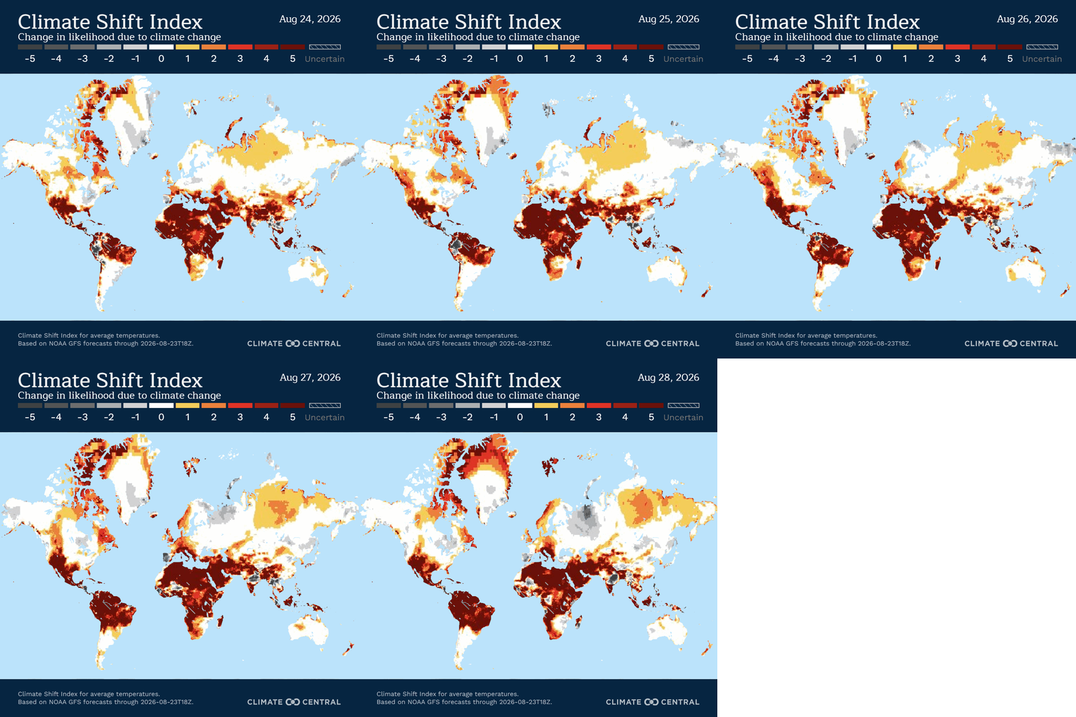
Locations featured are chosen based on data from Climate Central’s Climate Shift Index map. Some graphics used may also come from Climate Central’s Climate Shift Index map. Any original analyses contained in this blog or any views expressed in this blog, unless otherwise noted, are solely the expression of its authors and are unaffiliated with Climate Central or any other entity or person referenced within.1
Comments
Nothing yet. Say the first thing.
Sign in to join the conversation.