
Per leggere questo post in italiano (tradotto automaticamente da Google), clicca qui.
Can you help? We are working to make earthquake science accessible to the public, but this effort is entirely supported by readers like you. If you can, please consider supporting our work by upgrading to a paid subscription. If you use our Substack as part of a group, or for teaching, consider a teaching or institutional subscription. Every paid subscription makes a real difference — and unlocks access to the more than three hundred posts in our archive!
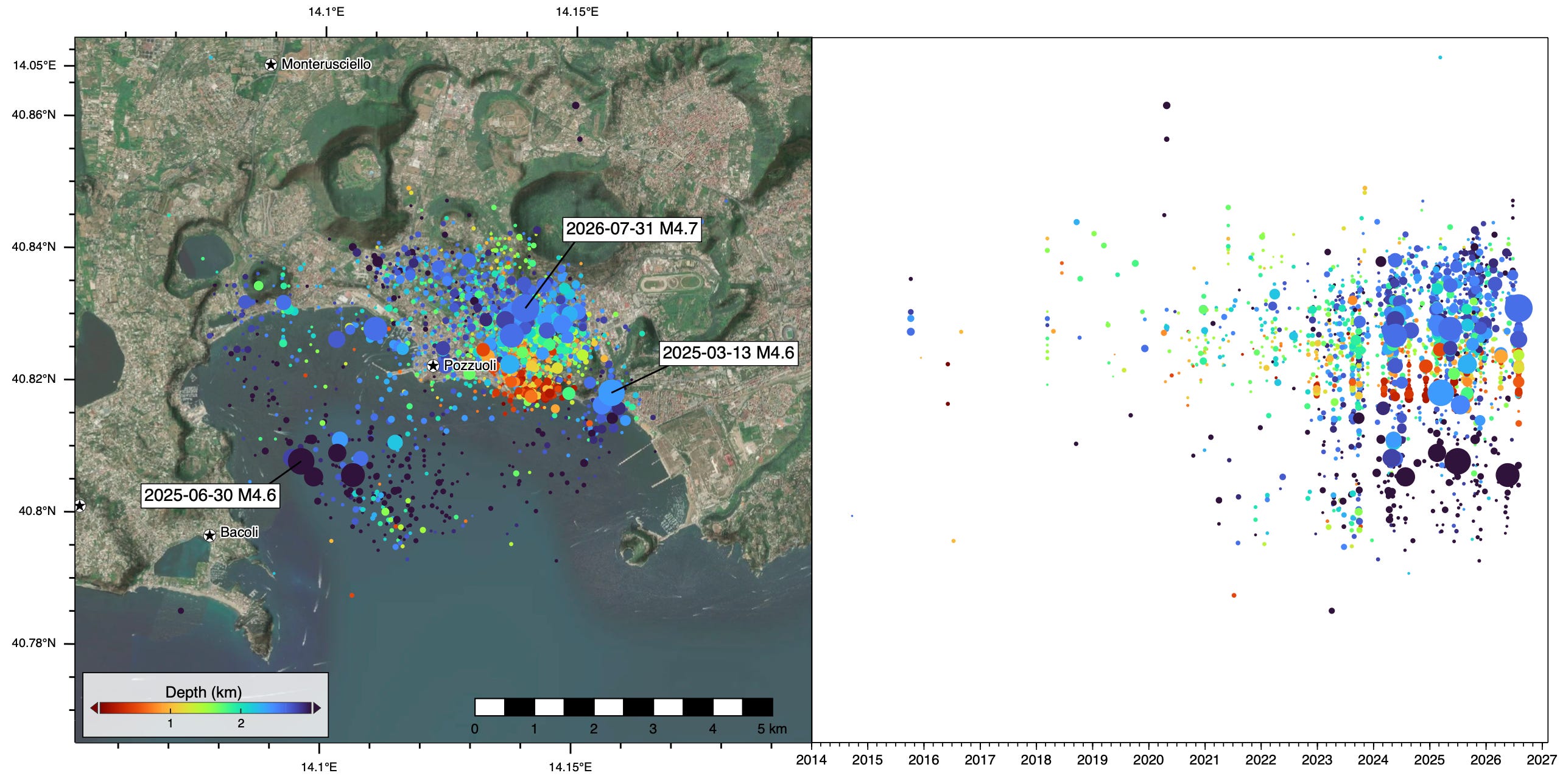
At 7:46 PM local time on July 31st, 2026, a magnitude 4.7 earthquake struck near Naples, Italy. The earthquake was shallow, and caused strong shaking locally. At least 26 people were injured, several unoccupied buildings collapsed, and part of a cliff crumbled. News reports indicate that many people spent the night outside (a very reasonable precaution in the days following an earthquake, when a large aftershock is most likely to occur).
The earthquake is notable not for its size, but for its location: it occurred within a large volcanic region known as Campi Flegrei. Campi Flegrei (in English, the Phlegraean Fields), is a coastal volcanic region defined by a large caldera, and pock-marked with 24 internal craters and volcanic edifices.
Like neighboring Vesuvius, Campi Flegrei is part the Calabrian Volcanic Arc. Often, we can simply say ‘this volcano arises from a such-and-such subduction zone’; and in fact, there is a subduction zone nearby. However, the actual link between that subduction and the Calabrian Volcanic Arc is somewhat debated. The volcanoes also lie in a region of crustal extension, driven by the dynamics of that subducting slab, which can itself cause significant volcanism. So, we must leave the discussion of the magmatic origin of Campi Flegrei to the experts.
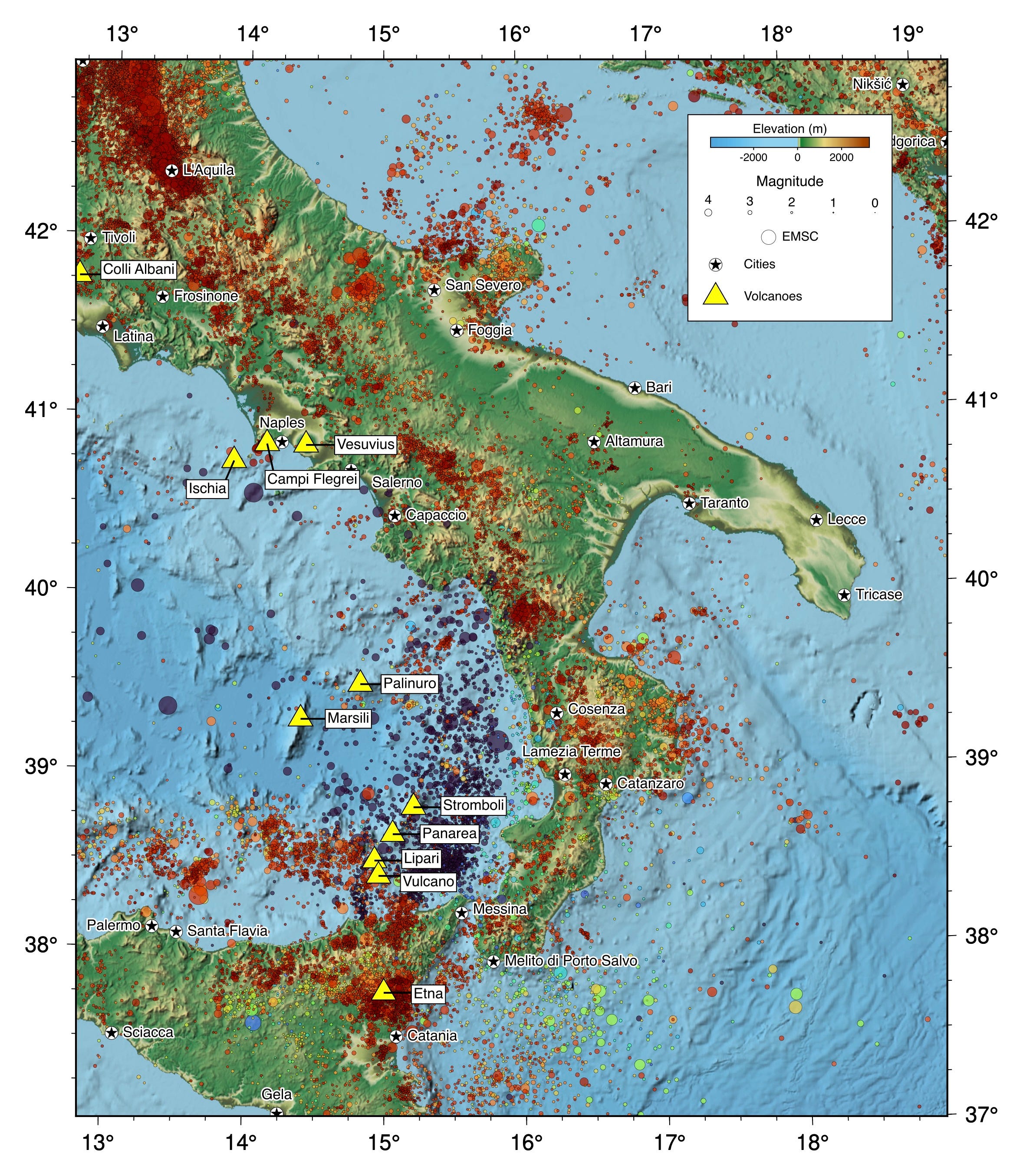
In any case, the volcanoes of the Calabrian Arc have had a major historical influence on the field of volcanology. Two types of eruptions now bear names derived from Calabrian Arc volcanoes: Strombolian (after the volcano Stromboli) and Plinian (after Pliny the Younger, who witnessed and wrote about the eruption of Mount Vesuvius in 79 CE, or possibly his uncle, Pliny the Elder, who died trying to rescue people from the eruption). And of course Vulcano shares its name with the entire discipline, both derived from Vulcan, the ancient Roman god of fire.
The overall volcanic system of which the Campi Flegrei caldera is but a part has been studied in great detail, and it is clear that it has been volcanically active for hundreds of thousands of years. While a small eruption of a secondary volcano would already be a trial, an eruption linked to great caldera itself would be a catastrophe, and thus is a subject of greatest concern. It is therefore unsurprising that any seismic activity at Campi Flegrei tends to raise some alarms.
Here at Earthquake Insights, we usually avoid writing about volcanic earthquakes. That is because earthquakes in and around volcanoes are usually just one dimension of a much larger system. Dedicated observatories look more holistically at the overall system: evaluating ground deformation, gas emissions, geothermal gradients, seismicity, and another seismic signal called volcanic tremor — aimed at assessing what is normal, what isn’t, and when the behavior of the volcano has crossed a boundary into hazardous territory.
That being said, the earthquakes in this region are quite interesting, and when they rise to the magnitude where they themselves cause damage, we get more curious. So, let’s take an outsider’s view of the recent seismicity in this area.
The map and timelines below show recorded earthquakes, as reported by the Istituto Nazionale di Geofisica e Vulcanologia (INGV), since January 1st, 2014. Earthquakes on the map are projected to the right onto a timeline. With this figure, it becomes immediately obvious that this magnitude 4.7 cannot be viewed in isolation: it is part of a long-lived swarm that started weakly in 2015 and intensified significantly in 2023, with a few apparent pulses. The recent magnitude 4.7 is the largest event in the swarm thus far, although a magnitude 4.6 last year isn’t far behind.
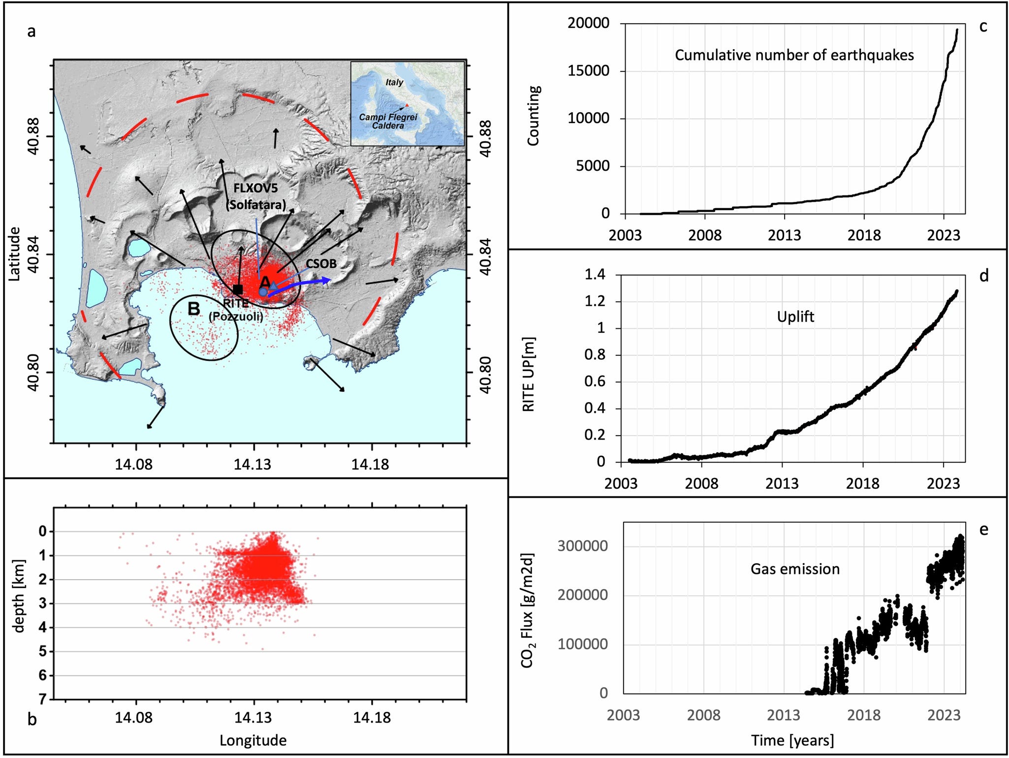
This seismic data is not the only indication of the onset of unrest at Campi Flegrei. In addition to seismicity, the volcano is currently ‘inflating’, and the flux of carbon dioxide has also been increasing. This figure, from Giudicepietro et al. (2025), shows that activity up through 2024. Their seismic dataset is clearly more complete than the INGV data that we show above.
The GPS arrows show radial movement away from the center of the caldera. And this “bull’s-eye” from satellite radar imaging (InSAR) is also very impressive; it shows uplift that extends even beyond the caldera rim.
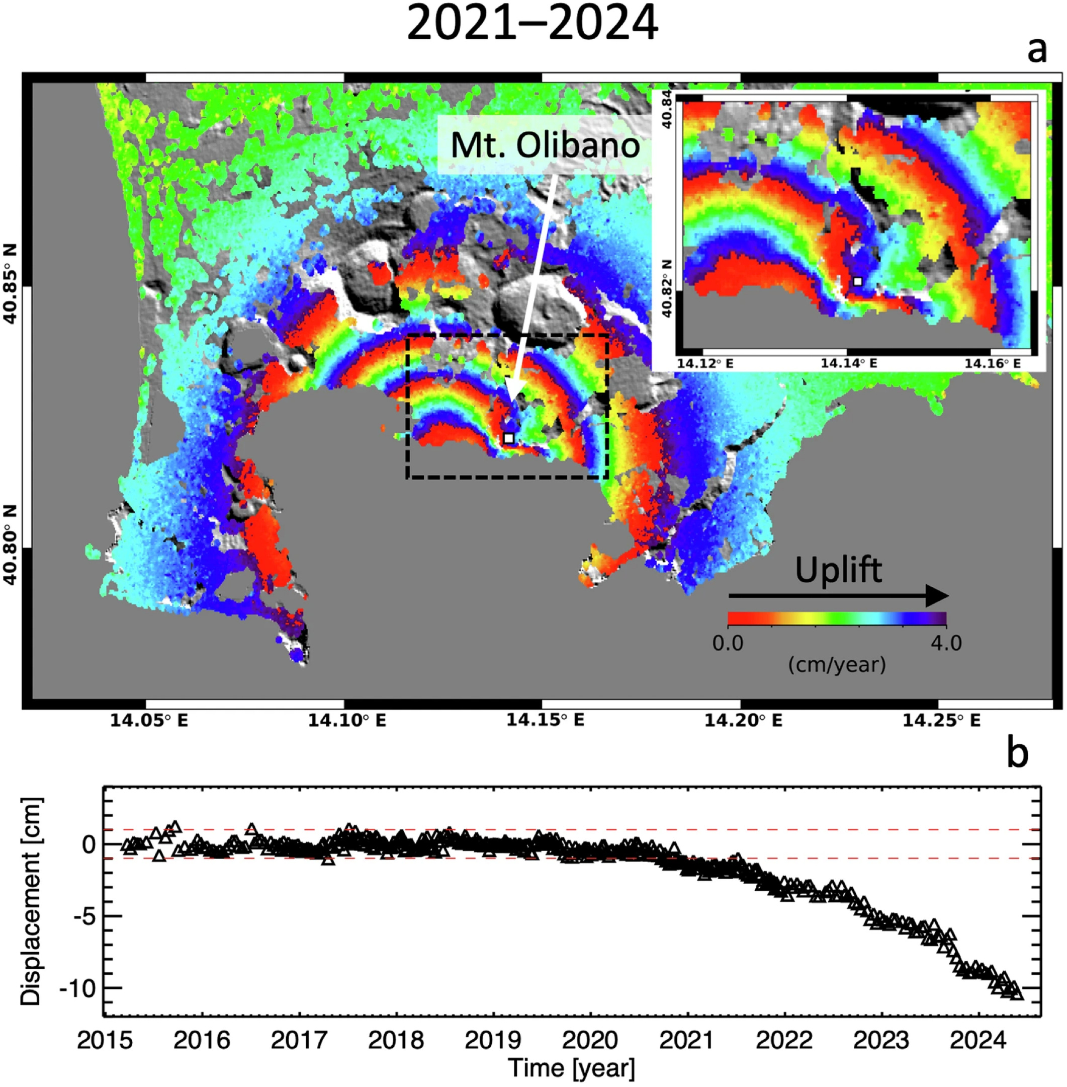
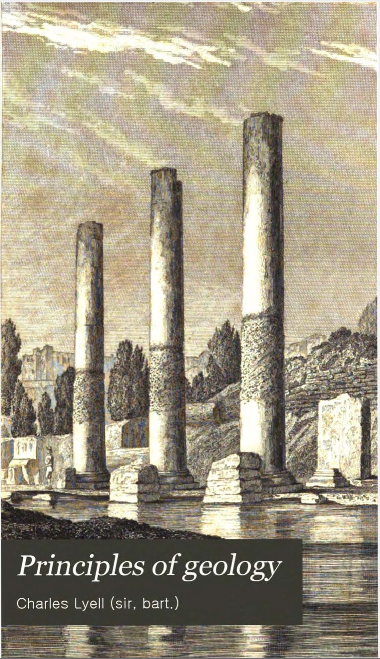
As you might imagine, the heavings of a large coastal volcano will necessarily lead to uplift and subsidence of the shore. This slow process of flooding and emergence along the coastline was most famously discussed by the great Charles Lyell, who visited Campi Flegrei in the 1828 and took note of the Temple of Serapis (although we are told that the correct term is the now the Macellum of Pozzuoli, and it was marketplace and not a temple; archaeologists can freely weigh in). This site is located right smack in the middle of the caldera, basically in the bullseye of the InSAR image above. Lyell noticed that the great standing columns of the ruined temple had been bored into by Lithophaga (rock eaters) — marine boring mollusks. To achieve this, the temple must have been built on land, subsided down below the sea by at least twenty feet, and then risen again into the air; and all within the last 2,000 years, and without causing the pillars to actually fall over.
So great was this observation in Lyell’s mind that he placed an engraving of the temple on the very first page of his magnum opus Principles of Geology, perhaps the most influential book of geology ever written (in three volumes):
If anyone suspects that Lyell’s book makes for boring reading, think again. Regarding the volcanoes of Campi Flegrei, Lyell said:
… geologists seem to have generally conjectured that the whole [volcanic] group sprung up from the ground at once, like the soldiers of Cadmus when he sowed the dragon’s teeth. As well might they endeavor to persuade us that on these Phlegræan Fields, as the poets feigned, the giants warred with Jove, ere yet the puny race of mortals were in being.
Some seriously saucy stuff! A global travelogue, a personal manifesto, a visionary textbook, and a field notebook combined into three volumes. Five stars.
Apparently, 1828 was a busy year: early computer expert Charles Babbage was also scrambling around in the bushes of Serapis, taking copious notes — although he apparently did not meet Lyell there. He published his own interpretation in 1847, featuring sections like “Of the Great Incrustation” and “List of Fragments.” In fact, he made detailed measurements of every column fragment he could find:
He even calculated how much the ground should uplift by simple volumetric expansion if a layer a mile thick was heated 500 degrees (conveniently: 25 feet). To be clear: this is not considered a physically plausible explanation today.
Like Lyell, Babbage interpreted the upheavals at Campi Flegrei as records of a slow and periodic process, perhaps but not certainly punctuated by earthquakes. In 1835, only a few years after Lyell’s book was published, Charles Darwin famously witnessed the dramatic uplift of the Chilean coastline due to a truly huge earthquake. Together, these two observations of coastal uplift — one slow and periodic, another sudden and permanent, would become profoundly important to the eventual scientific acceptance of a truly dynamic, ever-changing, Earth. Neat.
Lyell and Darwin both died long before science could adequately explain how volcanism could cause the periodic uplift and subsidence of the Temple of Serapis. In fact, there are still some pretty fundamental questions today, such as the different roles of magmas, gases, and fluids in the subsurface. That being said, we believe that those two great observationalists would have had no trouble coming up with some solid conclusions, had they the kind of data we have now.
So what is happening beneath Campi Flegrei? We will dip our toes into the deep waters of this subject by looking a few recent papers.
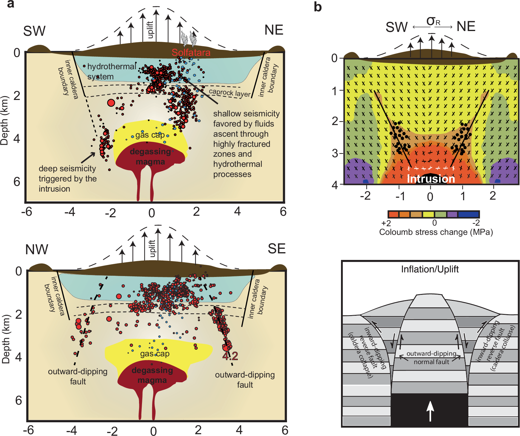
A study of Giacomuzzi et al. in 2025 carefully relocated the earthquakes to generate a more precise image of what is going on. The seismicity, they say, comes into two parts. The shallower earthquakes are related to rising hydrothermal fluids. Those fluids can come straight out of the magma itself via degassing, or they can be crustal fluids that are circulated by the heat. The deeper seismicity traces a ring above the inferred magma, and is related to stresses generated by the magma itself, including possibly new intrusions into the reservoir. The stresses drive plug-like motion of the crust in the caldera interior via slip on ring-like faults.
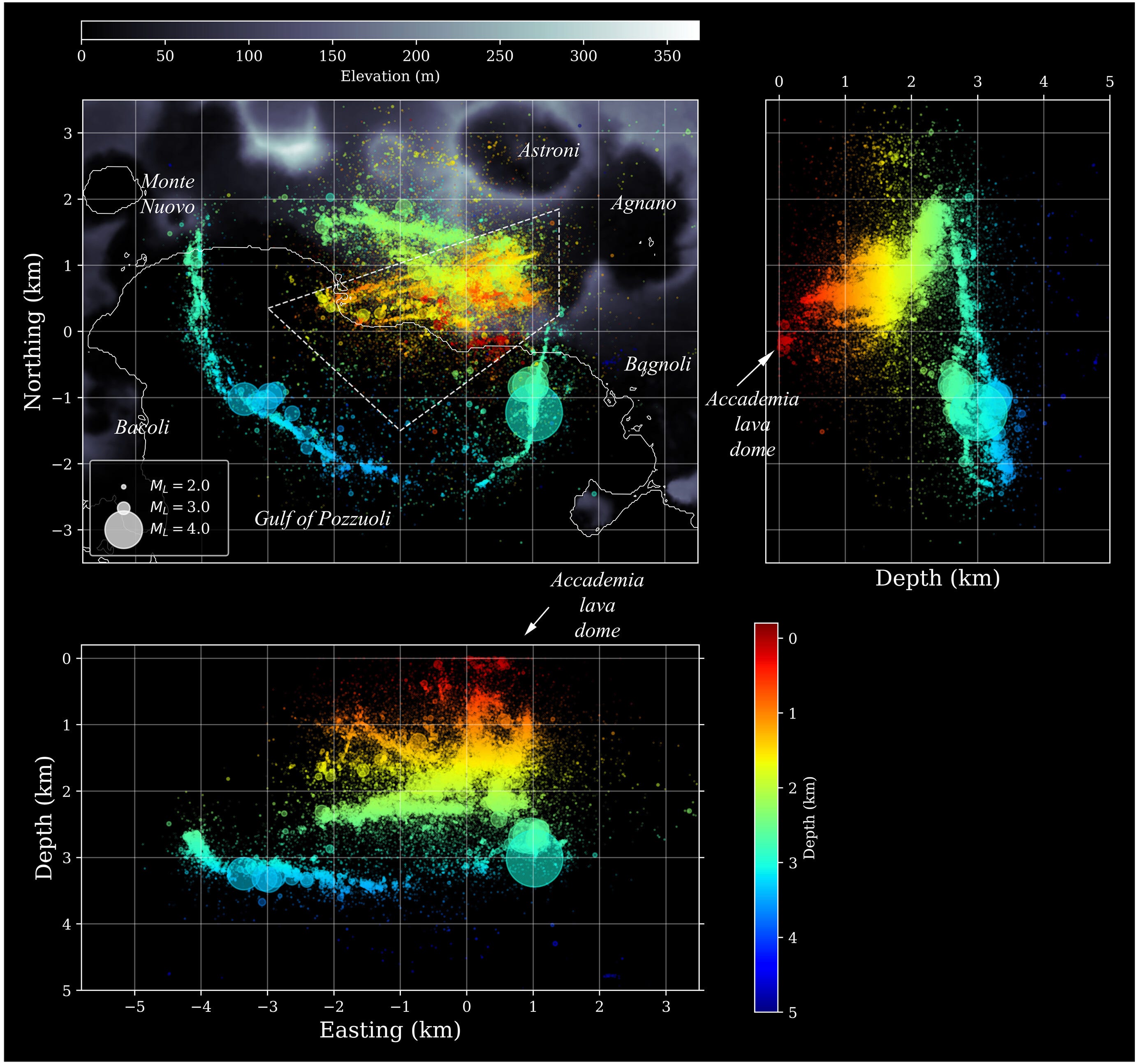
Another study in 2025 by Tan et al. took a deeper look at the seismic data — searching for more, tinier earthquakes in the seismic recordings using machine learning methods. Using this approach, they identified more than 54,000 earthquakes over an ~3 year period — more than four times as many as recorded by INGV, and more consistently located. Those earthquakes provide a remarkable picture of the system, with a clean ring of earthquakes defining the edge of the caldera system, and interior cross-cutting faults oriented east-northeast/west-southwest.
These two collections of earthquakes are also different in type: the outer, deeper earthquakes are mostly thrust-type events, oriented parallel to the ring faults themselves, while the interior shallow earthquakes are overwhelmingly normal-type events, oriented northeast-southwest.
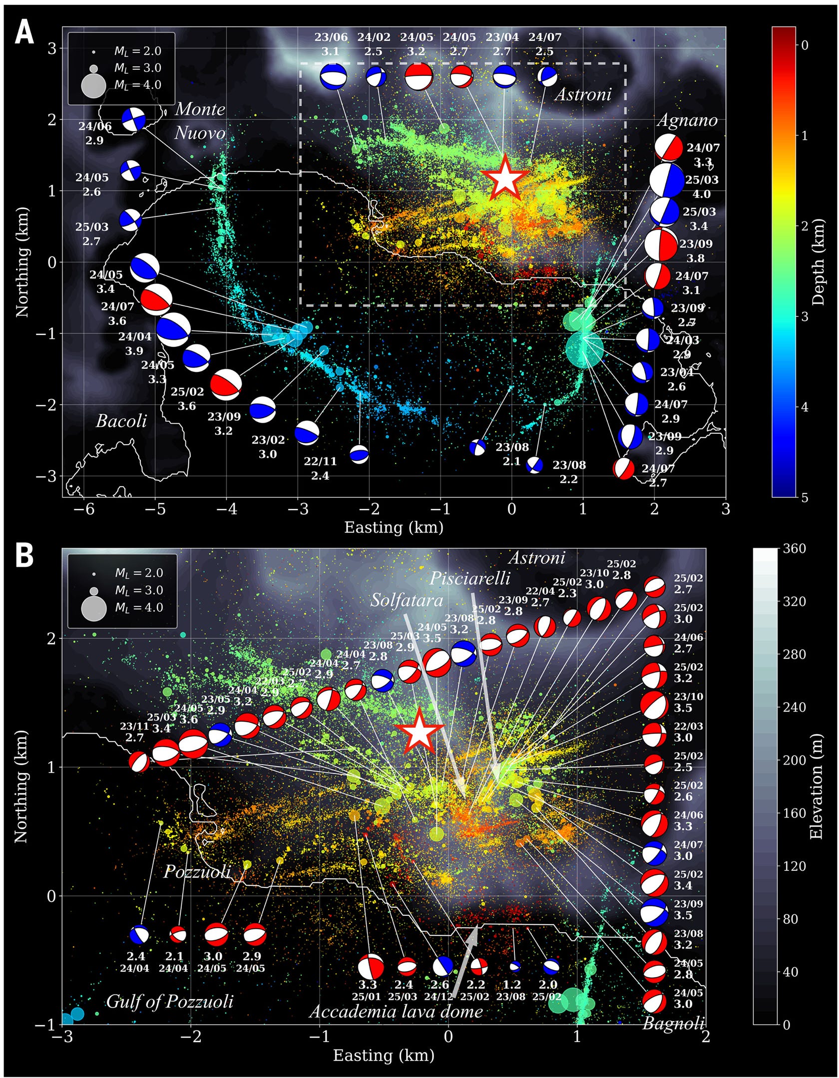
This is a truly spectacular view of a huge and important system, and it is a good representation of the advances made in earthquake detection and location by machine learning techniques.
Based on this, can we guess which fault system hosted this latest magnitude 4.7 earthquake? It turns out that this is pretty tricky, from our point of view.
We have placed the earthquake on the maps above as a star, using the INGV location. This puts it close to both the shallow interior faults, and the northern ring faults. The depth is also not particularly useful: EMSC reports a depth of 2 kilometers; INGV a depth of 3 kilometers — a range that could match either system. The focal mechanism, provided by INGV, shows a normal-type earthquake (white in the middle, like a normal Oreo), which seems like it should point to the interior faults. However, if you look back up at the map, the northern ring faults are the exception to the rule: rather than producing thrust-type earthquakes, they, too, seem to have normal earthquakes.
The previous “large” earthquakes in this system have been ring fault events, presumably because that fault system is both deeper in the crust and perhaps has larger continuous areas capable of rupture. If we had to choose, we would interpret this as a ring fault earthquake along the northern ring fault.
According to the Smithsonian Global Volcanism Program, the last known eruption at Campi Flegrei was in 1538 CE; that eruption formed the Monte Nuovo cinder cone. The last massive eruption was much earlier: ~40,000 years. So eruptions here are geologically fairly common, but historically fairly uncommon.
Activity like we are seeing now, on the other hand, is historically common; this is probably the exact same process that bobbed the Temple of Serapis up and down over thousands of years. This is a large active volcano, and some level of “breathing” is normal — there is magma down there, and a hydrothermal system on top. Movement of the crust does not mean that an eruption is imminent. In fact, measurements of vertical ground displacement from 1905 to 2023 at Puzzuoli port, Rione Terra show that stasis is the rare exception, not the norm. Lyell and Babbage inferred a maximum range of ~5-6 meters of vertical movement; a similar amount of movement has been documented over the last century.
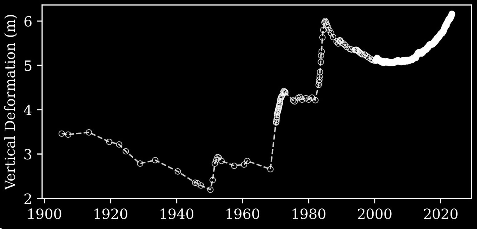
From this record we can see a general pattern: long, slow periods of subsidence separated by short, rapid periods of uplift. There was uplift in the 1950s, then again from 1969 to 1972, and again from 1982 to 1984, each time paired with increased seismicity. This latest period of uplift looks different: it has lasted longer (~2005-present), and is occurring more slowly; the increased seismicity didn’t start right away, but has certainly taken off in the last few years.
With only a few decades of detailed instrumental observation, it isn’t possible to know the full range of expected behaviors. But we can certainly say that many periods of increased seismicity, both here and at other volcanoes, pass without a major eruption.
That does not mean that they pass without consequence. The 1982-1984 crisis caused damage to buildings, roads, and water and sewage lines; people’s lives were disrupted by an evacuation; and the ground uplift affected the functionality of a harbor. The latest magnitude 4.7 caused rockfalls and building damage, and sent some people to the hospital. When earthquakes are shallow and close to populated areas, even small events can have real impacts.
Further, as noted by the INGV, “The three volcanic systems in Campania are currently quiescent but it is possible that they will erupt in the future. Their eruptive style — mainly explosive or mixed — and their location in densely populated areas with infrastructural, historical and artistic heritage of inestimable value, make the Neapolitan, Phlegrean and Ischia areas at high risk.”
Campi Flegrei is monitored by the Vesuvian Observatory; they classify the current state of the volcano as alert level yellow (medium) which is above green, but below orange and red. This classification should be viewed as the definitive authority of present hazard.
And as always, if any of our readers have any corrections or clarifications, please let us know in the comments!
Babbage, C., 1847. Observations on the Temple of Serapis. https://darwin-online.org.uk/converted/pdf/1847_Babbage_Serapis_A3251.pdf
Giacomuzzi, G., Fonzetti, R., Govoni, A., De Gori, P. and Chiarabba, C., 2025. Causal processes of shallow and deep seismicity at Campi Flegrei caldera. Communications Earth & Environment, 6(1), p.70. https://doi.org/10.1038/s43247-025-02045-2
Giudicepietro, F., Avino, R., Bellucci Sessa, E., Bevilacqua, A., Bonano, M., Caliro, S., Casu, F., De Cesare, W., De Luca, C., De Martino, P. and Di Traglia, F., 2025. Burst-like swarms in the Campi Flegrei caldera accelerating unrest from 2021 to 2024. Nature Communications, 16(1), p.1548. https://doi.org/10.1038/s41467-025-56723-y
Lyell, C., 1830-1833. Principles of Geology: Being an Attempt to Explain the Former Changes of the Earth's Surface, by Reference to Causes Now in Operation.
Tan, X., Tramelli, A., Gammaldi, S., Beroza, G.C., Ellsworth, W.L. and Marzocchi, W., 2025. A clearer view of the current phase of unrest at Campi Flegrei caldera. Science, 390(6768), pp.70-75. https://doi.org/10.1126/science.adw9038
Comments
Nothing yet. Say the first thing.
Sign in to join the conversation.