
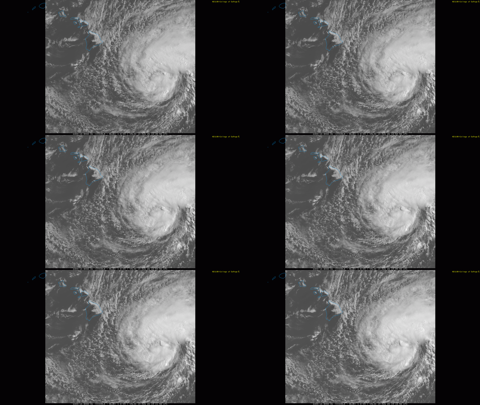
Sunrise over the central Pacific this morning revealed an increasingly better organized Tropical Storm Lala to the southeast of the Big Island of Hawai’i. The most intense storms and winds are in a curved band north of the center, but some thunderstorms have been developing recently closer to the center. Maximum sustained winds are now 60 mph in Lala as it moves west-northwest at 12 mph. A hurricane hunter aircraft just took off from Kona on the western side of the Big Island, and will soon give us a better idea of Lala’s current intensity.
![[Key Messages]](https://substackcdn.com/image/fetch/$s_!6a14!,f_auto,q_auto:good,fl_progressive:steep/https%3A%2F%2Fsubstack-post-media.s3.amazonaws.com%2Fpublic%2Fimages%2F667fa93e-bf23-400b-8b88-ae4b3c109fab_897x736.png "[Key Messages]")
Wind shear has weakened in the vicinity of Lala in the last 48 hours, and conditions are expected to remain favorable for gradual intensification as the storm approaches the Big Island over the next 24 hours. It is forecast to be a category 1 hurricane as it passes over or near the southern part of the island Saturday evening (Hawaiian time).
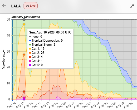
The intensity forecast in the models has come up quite a bit in the last 24 hours, and given the latest trends of increased organization on satellite this seems reasonable. This morning’s Google DeepMind AI (GDM) ensemble actually explicitly shows Lala becoming a category 2 hurricane — and has about a 10% chance of Lala making major hurricane intensity before it reaches the Big Island of Hawai’i. It should be noted that GDM is on the stronger side of guidance — but most models do now show Lala becoming a hurricane before it reaches Hawai’i.
As my colleague Michael Lowry discussed in his Substack post this morning, if Lala were to actually make landfall on Hawai’i as a hurricane it would be the first hurricane to ever strike the Big Island on record, and only the third to strike the state.
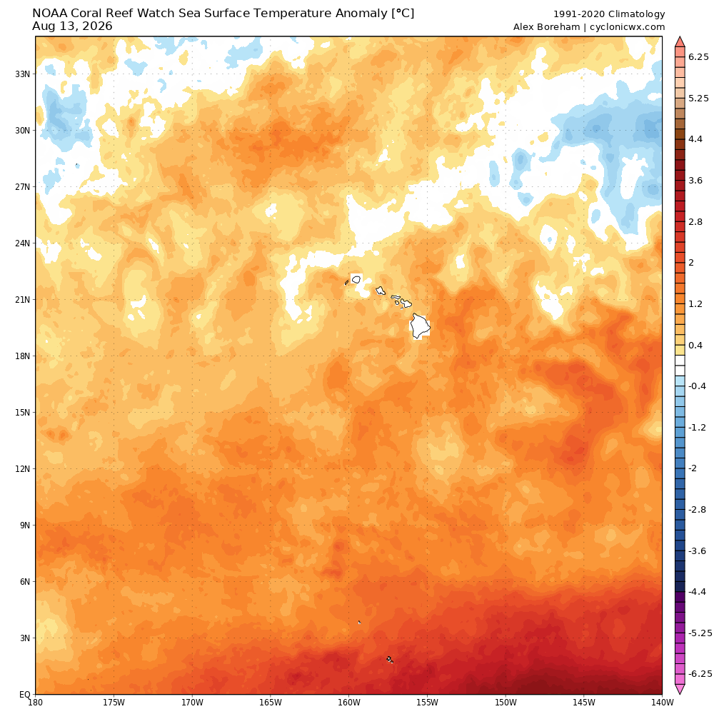
Typically, wind shear in the vicinity of Hawai’i is relatively strong, and combined with cooler sea surface temperatures these factors help “protect” Hawai’i from most direct impacts from strong tropical systems. However, El Nino tends to result in weaker wind shear in the region as we are currently seeing, and abnormally warm sea surface temperatures of 1-2C above normal are providing sufficiently warm oceanic conditions to support a hurricane.
![[Image of U.S. rainfall potential]](https://substackcdn.com/image/fetch/$s_!WQ_6!,f_auto,q_auto:good,fl_progressive:steep/https%3A%2F%2Fsubstack-post-media.s3.amazonaws.com%2Fpublic%2Fimages%2F3ab7e1a2-e932-406b-98fb-1d62063590e0_3300x2550.gif "[Image of U.S. rainfall potential]")
Strong winds — particularly in higher terrain and areas where easterly winds are enhanced by terrain — will be a major concern on the Big Island with Lala, as well as torrential rainfall locally in excess of 2 feet that could cause serious flash floods and mudslides. The rainfall impact will primarily be on the eastern (windward) side of the island where terrain will locally enhance rainfall — the western (leeward) side will have rain shadow impacts from the volcanic mountains of Hawai’i which will result in much less rainfall there.
Lala will likely undergo some temporary weakening due to land interactions with the Big Island as well as some increase in wind shear. As it passes south of the other Hawaiian Islands it will cause rough surf conditions particularly on south facing shores, as well as gusty winds and locally heavy rainfall. A hurricane warning is in effect for the Big Island, a tropical storm warning is in effect for Maui County, and tropical storm watch is in effect for O’ahu and Kauai County.
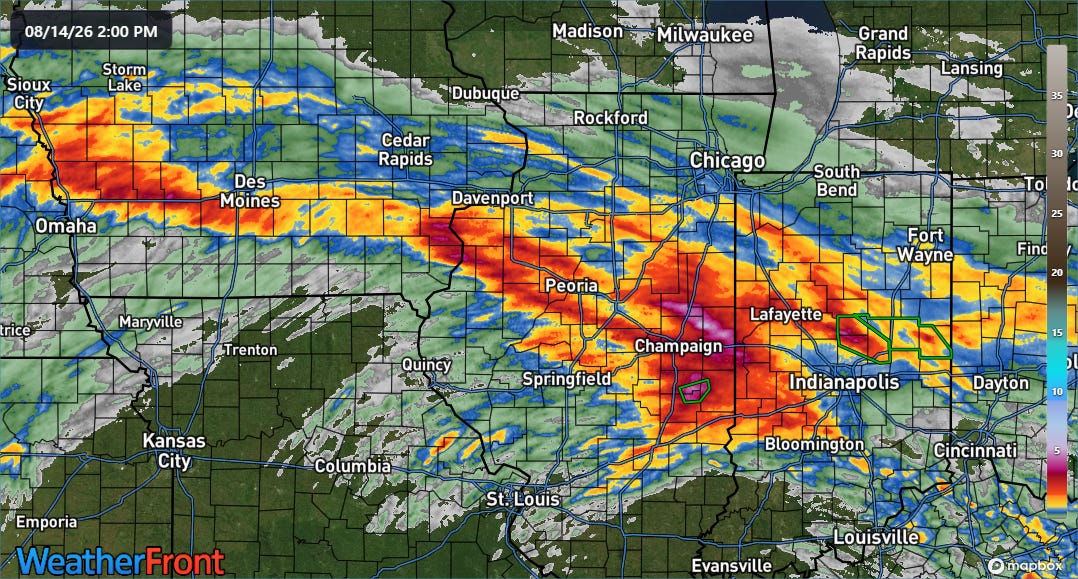
Back in the CONUS, heavy rainfall last night into this morning caused more flooding issues across the Midwest.
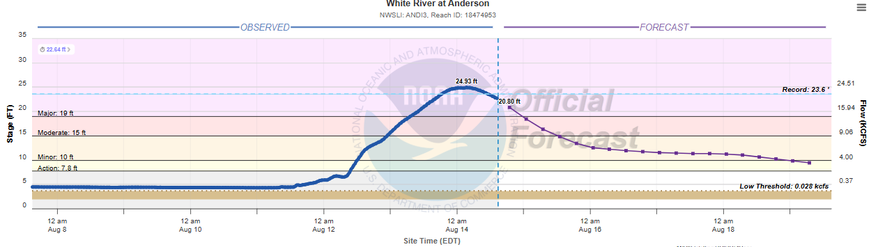
Not only has this caused flash flooding, but days of heavy rainfall are resulting in increasing issues with river flooding. East-central Indiana has been particularly hard hit, with the White River at Anderson shattering its 1913 record level by more than a foot. CBS News reports that entire neighborhoods in Anderson and nearby communities are underwater, resulting in numerous evacuations and water rescues.
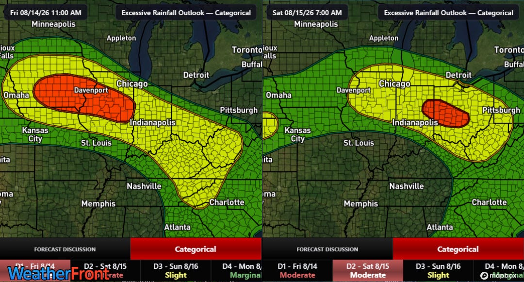
Clusters of thunderstorms with heavy rainfall will continue to develop and move east-southeast across the region. The Weather Prediction Center has moderate (level 3 of 4, red on maps above) risks of excessive rainfall and flash flooding both tonight (left) and Saturday into Saturday night (right).
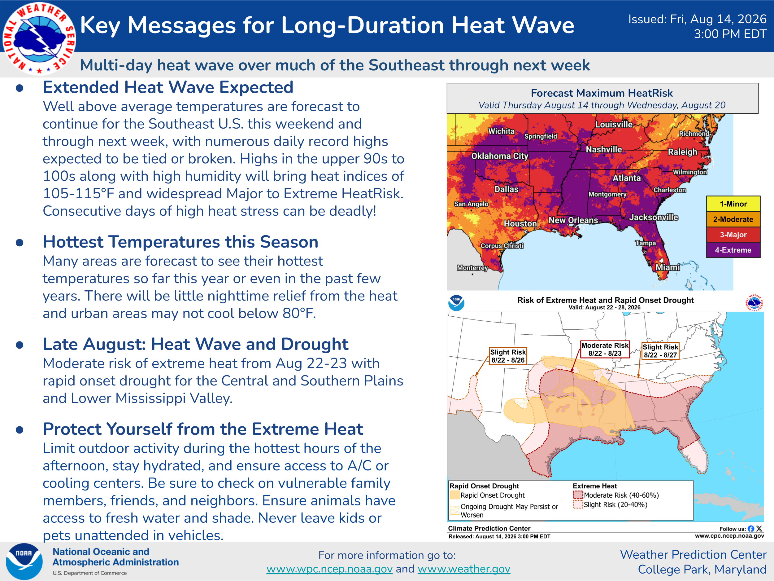
Extreme and at times record heat will also continue to be an issue into the weekend.
Programming note: Given the active weather expected into this weekend, I will likely be doing some Substack chats and possibly a live video or two. As a reminder, participating in these live events is a benefit that paid subscribers receive for their support of Balanced Weather.
Balanced Weather is made possible by the generous support of paid subscribers, who as thanks get access to live Balanced Weather chats and videos as well as the ability to post comments and ask questions on posts. To become a paid subscriber or a free subscriber (also very much appreciated and you will automatically receive new posts in your email), please click below.
No posts
Comments
Nothing yet. Say the first thing.
Sign in to join the conversation.