
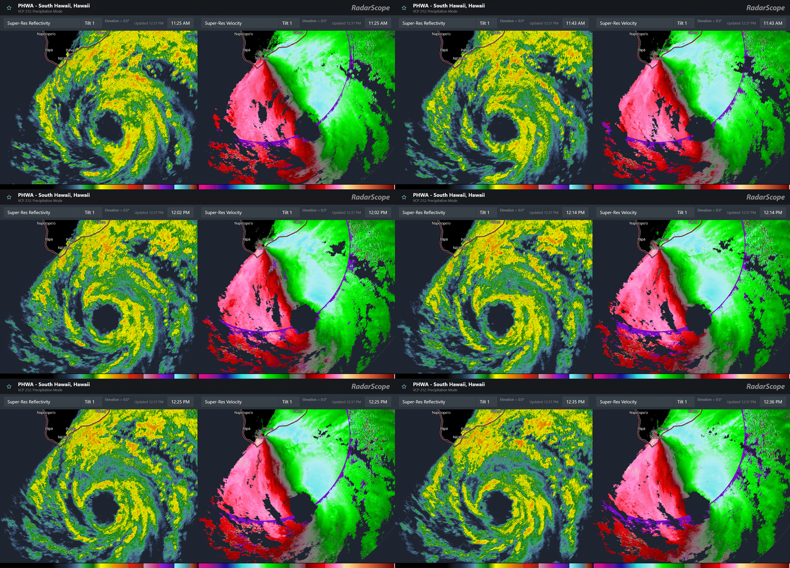
Tropical Storm Lala has been gradually becoming better organized over the last 12 -18 hours to the south-southeast of Hilo on the Big Island of Hawai’i. Colder topped convection has been surrounding the center on infrared satellite, and radar data shows an increasingly organized system with bands of heavy tropical showers surrounding an eye feature.
The South Point Doppler weather radar has been showing increasing winds north of the center, with a large area 65 to 75 mph winds. These winds are several thousand feet aloft, meaning winds of up to 70 mph are likely occurring at the surface in this area. Gradual intensification is expected for the next 12 hours or so, and it will not take much increase in intensity for Lala to become a hurricane.
The loop of velocity data from South Point also shows strong winds of 60 to 70 mph in the outer bands of Lala now reaching the southeast coast of the Big Island. While these winds are also aloft, they will begin to be mixed down in wind gusts by heavier showers — and also as these bands with their strong winds aloft start to impact higher elevations, those winds will be impacting the surface at those higher elevations. This is why even if Lala were not to actually make hurricane intensity, hurricane force gusts will likely still occur, and sustained hurricane force winds could occur at higher elevations.
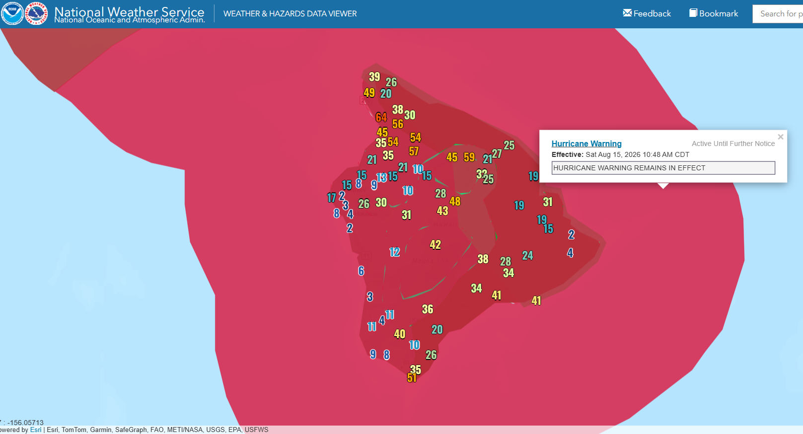
In this current wind gust map, we can see that tropical storm force (greater than 39 mph) gusts are already occurring along the southeast coast of the Big Island. Actually, though, the strongest winds are actually occurring on the northern side of the island — this is likely due to the stronger winds that are hitting the mountains accelerating as they move over the mountains and down toward the coast on the leeward side. These sorts of localized terrain influences will play a big role in the sensible impacts of Lala for Hawai’i.
![[Image of U.S. rainfall potential]](https://substackcdn.com/image/fetch/$s_!Yivd!,f_auto,q_auto:good,fl_progressive:steep/https%3A%2F%2Fsubstack-post-media.s3.amazonaws.com%2Fpublic%2Fimages%2Fb504f917-20f7-46f2-b713-75ba934f674f_3300x2550.gif "[Image of U.S. rainfall potential]")
This includes rainfall and flooding, as the heaviest rain is expected on the windward (eastern) side of the islands. The most impactful rain and flooding is expected on the Big Island with as much as 25” expected in the higher terrain on the eastern side of the island.
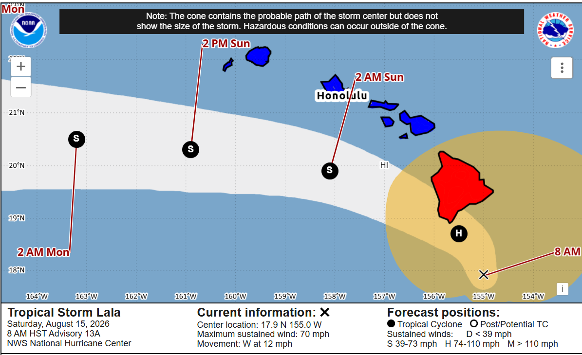
The high volcanic mountains of the Big Island will also likely affect the motion and structure of Lala. As it gets closer to the island, those downslope winds I discussed above will cause lower pressure on the western side of the island which could result in Lala turning more toward the island. The terrain will likely also start causing some weakening as the center makes its closest approach (or even passes over) the southern tip of the island this evening (times on the map are Hawaiian time). Once it passes the Big Island it should resume a more westward motion to the south of the other Hawaiian Islands. Heavy rainfall, flash flooding, large surf (particularly on the the southern coasts of the islands) and tropical storm force winds are expected through the weekend.
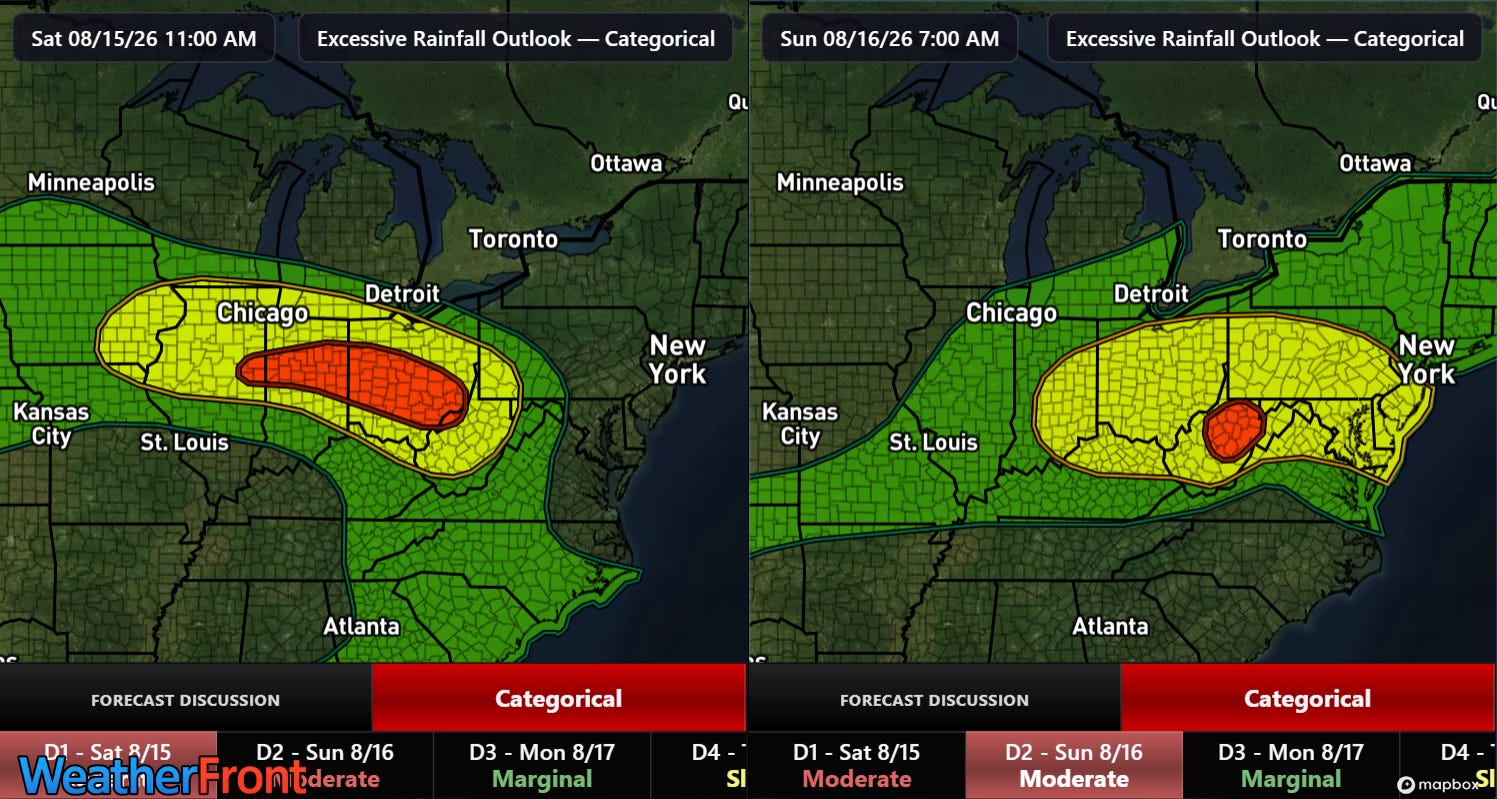
Stateside, the biggest weather stories this weekend will continue to be the heat across the southern United States, and clusters of thunderstorms moving through the Midwest and Mid-Atlantic producing heavy rainfall and additional significant flooding. The Weather Prediction Center continues to have moderate (level 3 of 4) risks of flash flooding in place the next couple of days. Severe weather will also be possible with these storms, with damaging wind gusts the primary risk.
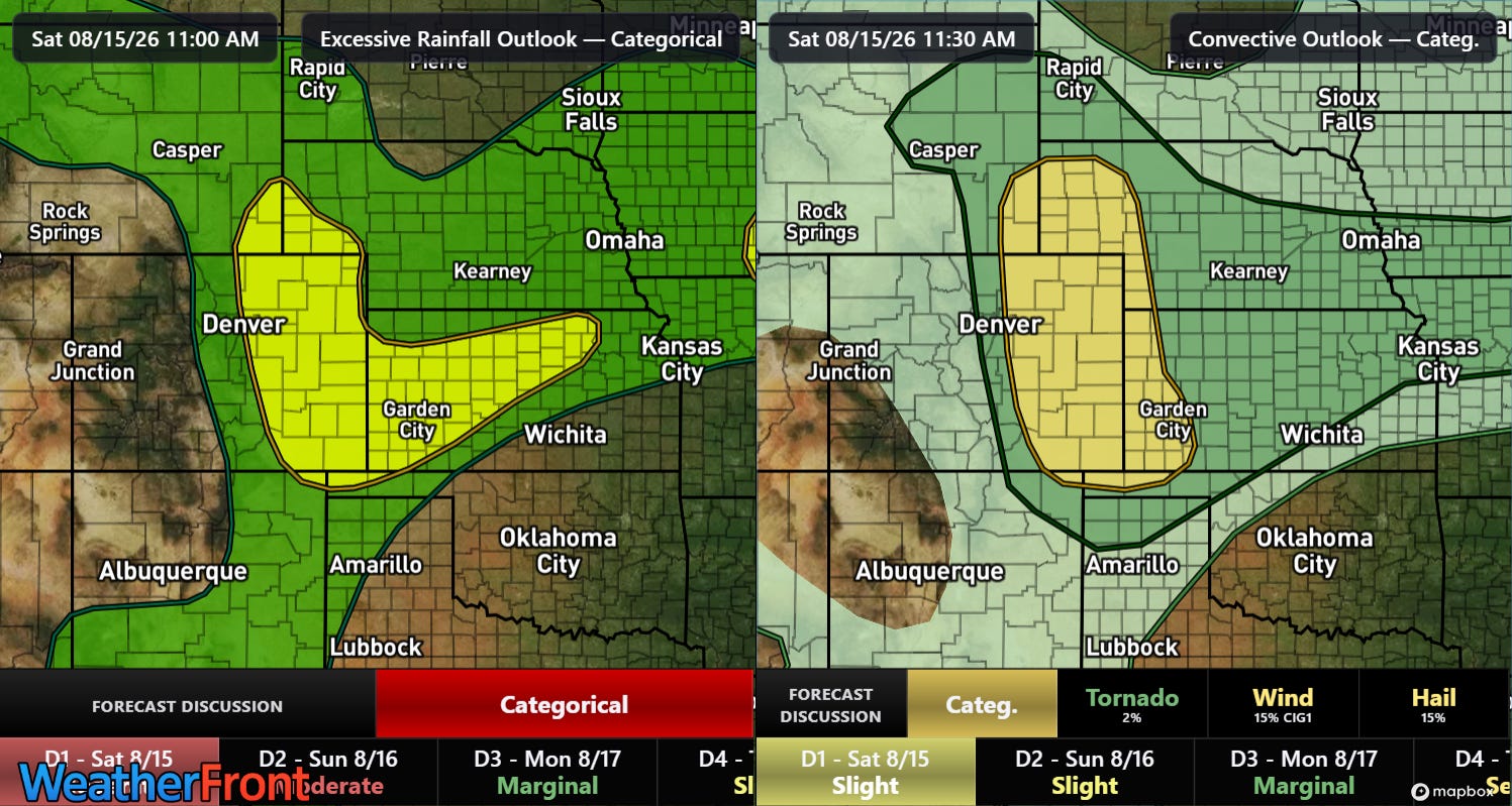
Monsoonal moisture surging up into the Rockies will also bring thunderstorm activity that will have risks of severe weather and flash flooding associated with it, particularly in eastern Colorado and adjoining areas.
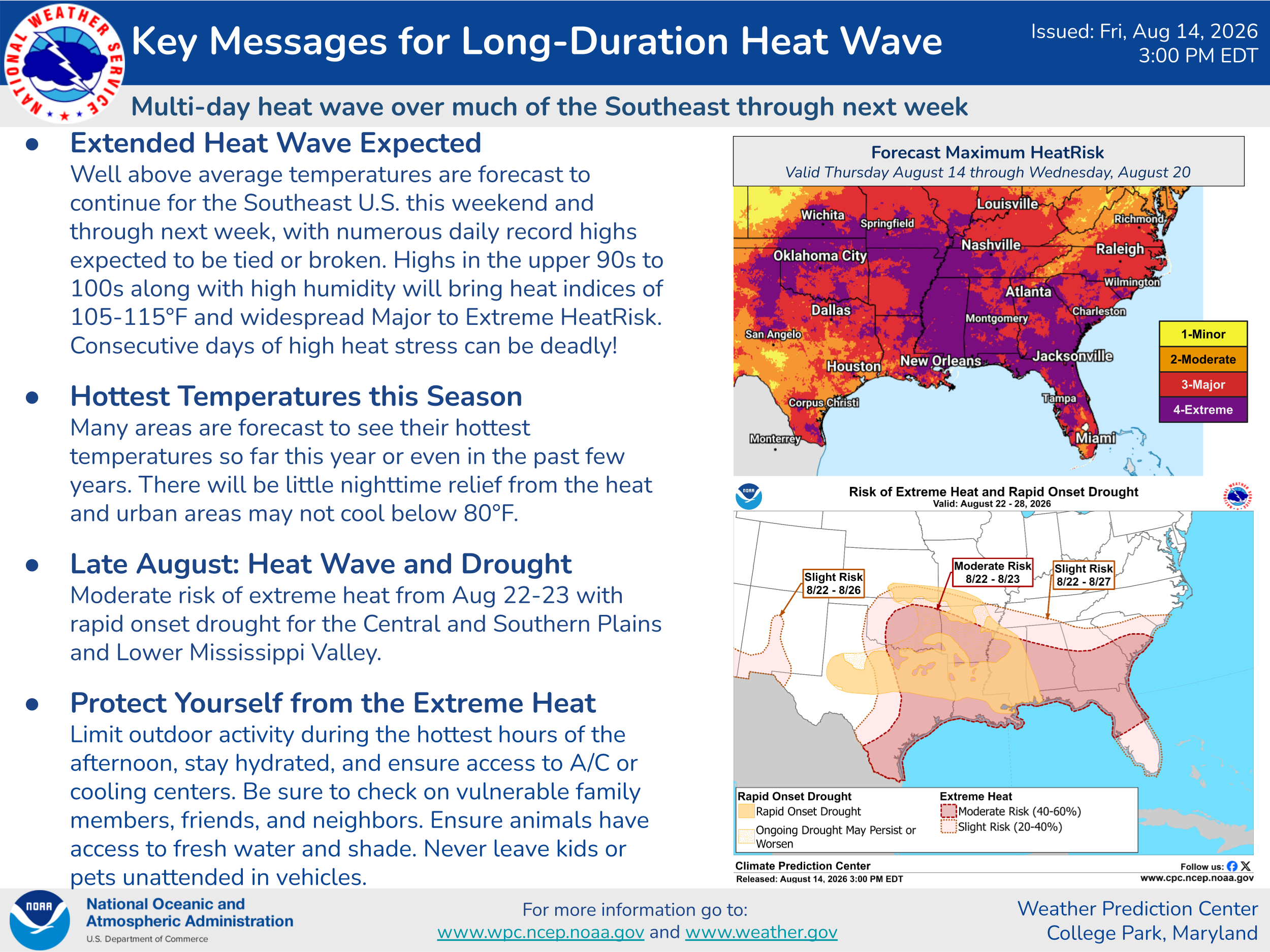
The heat is not going anywhere anytime soon across the Southern US - with major to extreme heat risk and a number of record warm temperatures expected into next week.
Given the active weather expected this weekend, I will be doing some Substack chats and possibly a live video or two. As a reminder, participating in these live events is a benefit that paid subscribers receive for their support of Balanced Weather. Any videos I do will be posted for all subscribers as soon as I can get them processed.
Balanced Weather is made possible by the generous support of paid subscribers, who as thanks get access to live Balanced Weather chats and videos as well as the ability to post comments and ask questions on posts. To become a paid subscriber or a free subscriber (also very much appreciated and you will automatically receive new posts in your email), please click below.
Comments
Nothing yet. Say the first thing.
Sign in to join the conversation.