
In the last two reports, we looked at two very different regional navigation stories. India’s NavIC showed us what happens when a small, strategically important constellation comes under strain. Japan’s QZSS showed the opposite: another regional system, that is able to absorb a launch failure without immediately falling below its service threshold.
China’s BeiDou-3 sits in a different category altogether.
It is a layered PNT architecture built around global MEO coverage, regional GEO and IGSO reinforcement catering short-message services, augmentation, precise point positioning, and a growing terrestrial and space infrastructure around it. That makes it harder to compare cleanly with NavIC, QZSS or even the pioneering GPS. It is also far more interesting to study.
The most recent reason is Iran.

During the 2026 start-stop war with Israel and the United States, open-source reporting repeatedly raised the same question: was Iran using BeiDou to improve the accuracy and resilience of its missile and drone attacks? The careful answer is: possibly, but not conclusively proven. The more important answer is: even the possibility rewrites the regional PNT calculus.
For years, GPS denial had a simple logic: jam or spoof the signal to degrade weapons. Multi-GNSS makes that harder. A missile or drone blending inertial navigation with GPS, GLONASS, BeiDou, and anti-jam antennas is no longer a single-signal target. The advantage is not magic precision. It is just more resilient, with more signals to use, more chances to correct drift, and fewer clean kill switches for electronic warfare.
The National reported analyst claims about BeiDou-capable receivers and Chinese navigation components in Iranian systems. A March 2026 U.S.-China Economic and Security Review Commission fact sheet says China granted Iran full military access to BeiDou in 2021. But none of this proves BeiDou guided specific attacks, or separates it cleanly from GPS, GLONASS, inertial navigation, or other aids. The safer claim is that BeiDou may now be ‘part’ of Iran’s wartime navigation resilience. That alone is significant.
BeiDou-3’s hybrid MEO/GEO/IGSO architecture is not a GPS clone. It is an actively managed, multi-layered system. Through its orbital behavior, we observe this constellation being sustained deliberately and with utmost care.
BeiDou-3 is healthy, not boring
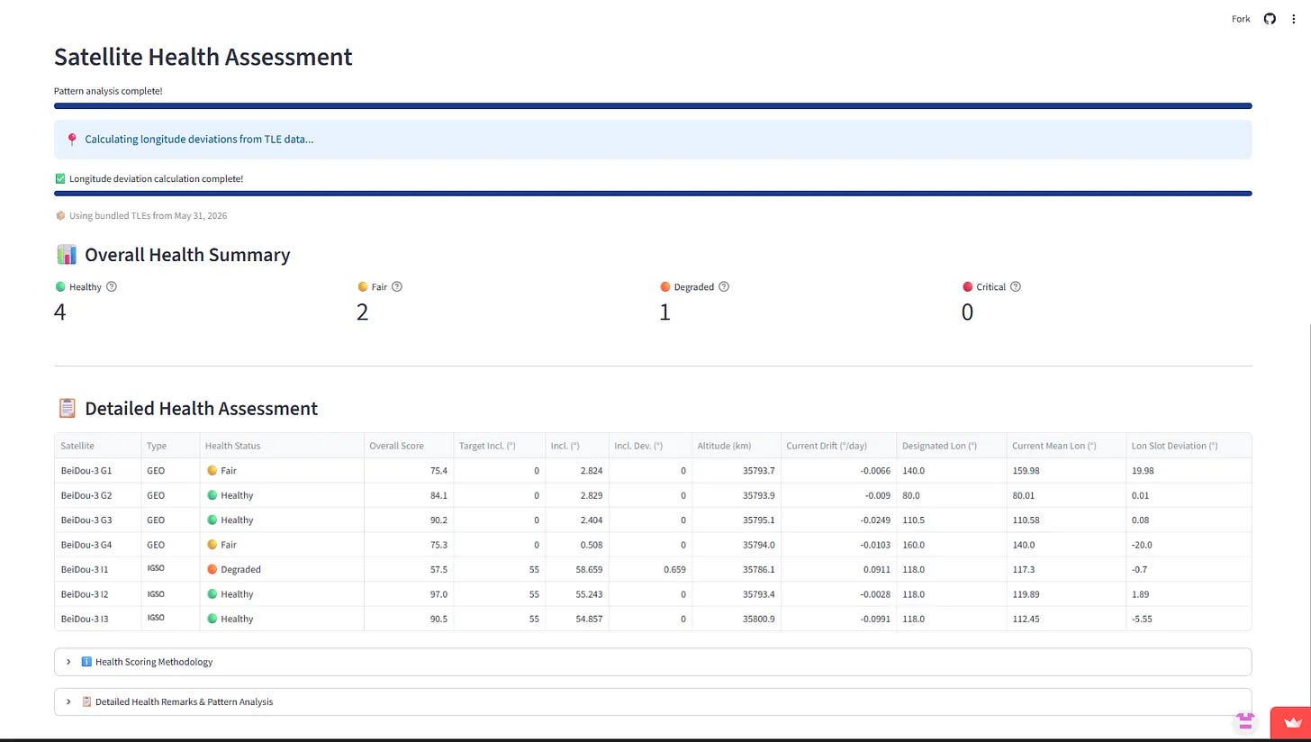
Our GNSS Health Monitor currently focuses on geosynchronous satellites. With NavIC and QZSS covered, it makes BeiDou the next natural target because BeiDou is the only global GNSS that still retains a large regional geosynchronous layer as part of its architecture.
The full BeiDou-3 (BDS-3) constellation design consists of 24 MEO, 4 GEO, and 3 IGSO satellites. The MEO layer provides global service. The GEO and IGSO satellites are there for regional reinforcement, especially over China and the Asia-Pacific. Literature on BDS-3 describes this as a hybrid architecture that supports global PNT while preserving regional services such as short-message communication, satellite-based augmentation, and Precise Point Positioning (PPP).
The health picture is broadly strong. But the interesting part is not the average. It is the contrast between very tightly controlled satellites and satellites that appear to be undergoing relocation or relaxed maintenance.
BeiDou-3 shadows BeiDou-2

The Tarot visualization above illustrates something that is easy to miss if we only look at BeiDou-3 in isolation: BDS-3 GEO satellites are not merely occupying useful longitudes. They are occupying pretty much the same longitude slots as the older BDS-2 satellites. CelesTrak TLEs from June 20-21, 2026 show a near one-for-one pattern:
With reports indicating seven to thirteen BDS-2 satellites slated for retirement — accounts differ on whether this covers an initial tranche or the full campaign — the moves made by BDS-3 satellites need to be interpreted with more nuance. BDS-3 is not simply adding fresh spacecraft to empty real estate. It is adding new capabilities while increasing capacity on legacy services until the transition is complete.
A controlled phase-out looks exactly like this from orbit: keep the working BDS-2 satellites near their original service slots while BDS-3 satellites take on the current architecture’s load, then gradually relax, relocate, or retire the older spacecraft as fuel budgets, service commitments, and replacement confidence allow. Surviving BDS-2 satellites continue broadcasting on their original B1I/B3I signals — the only signals they were ever built to carry — giving BDS-3 a regional backstop through the transition rather than an abrupt, all-at-once handover.
Discovery from Open Data
The strange case of G1 and G4
When we loaded BeiDou-3’s GEO satellites into the health monitor, G2 and G3 scored healthy. G1 and G4 did not — both showed low scores, and for the same reason: longitude slot deviation. But what made this interesting was the direction of each deviation.
G1 is assigned to 140°E. Its measured mean longitude was sitting close to 160°E. G4 is assigned to 160°E and its measured mean longitude was 140°E.
In other words: each satellite is occupying the other’s slot.

The Historical Central Longitude chart make the picture clearer. G1’s longitude history showed a move from 140°E toward 160°E — not uncontrolled drift, with the altitude maneuver signatures (check the dashboard for details) consistent with repositioning burns. G4 showed the mirror image: a departure from 160°E toward 140°E, with the same kind of controlled altitude behavior. The signature: G1 decreases altitude to set up an eastward drift, and G4 increases altitude to set up a westward drift before reversing these drifts to settle into their final longitudes.
The dashboard flagged a health warning because of the reference longitude slots. Orbital data show us that it was a deliberate slot swap.
Details from the Official Notification
The China Satellite Navigation Office (中国卫星导航系统管理办公室), or CSNO, published a new satellite-to-PRN assignment table on the official BeiDou website that fills in for logic that orbital data alone cannot provide. Under the new table, PRN 1 (G4) is assigned to the 140°E orbital slot and PRN 4 (G1) is assigned to the 160°E slot — which is what we would expect from the original design. But crucially, G4 was launched in May 2023 to the 160°E slot to serve as the first backup satellite for the BeiDou-3 system.
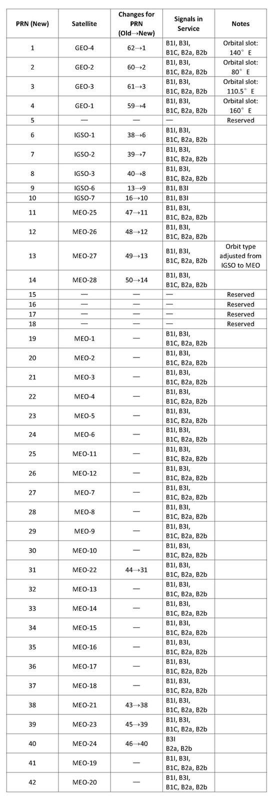
Note: IGSO-6 and IGSO-7 (PRN 9–10) in the above table are legacy BDS-2 satellites still broadcasting B1I/B3I only; BDS-3’s own IGSO layer is IGSO-1/2/3.
This changes how we should read the G4 movement. The 140°E slot was never vacated during this transition — G4’s move maintained continuous occupancy of that position before G1 took over 160°E. G4 departed first, clearing the 160°E slot so it could be re-designated as the GEO spare position; only once G4 had reached 140°E did G1 begin filling 160°E as a holding pattern. The accompanying PRN reassignment — with G4 now holding the prime PRN 1 designation at 140°E — has been communicated to multi-GNSS monitoring stations, ensuring receivers and ground infrastructure reflect the updated satellite-to-slot mapping.
G1: the satellite to watch
G1 is the oldest BeiDou-3 GEO satellite. Its age alone makes it a candidate for one of two outcomes: a maintenance cycle (allowing it to be brought back in a different role), or a retirement sequence ending its life in a graveyard orbit.
China demonstrated its GEO lifecycle management capability when Shijian-21 relocated an aging BeiDou-2 GEO satellite into graveyard orbit in January 2022. The Chinese precedent for actively managing end-of-life GEO assets already exists, making G1 worth tracking.
The stable counterparts: G2 and G3
In contrast to the dynamic relocation behavior of G1 and G4, the G2 and G3 satellites remained stable and tightly controlled. While the former underwent transitions, G2 and G3 displayed disciplined North-South and East-West station-keeping with drift rates near zero throughout the monitoring window. This stability reinforces that the G1/G4 activity is a targeted operation.
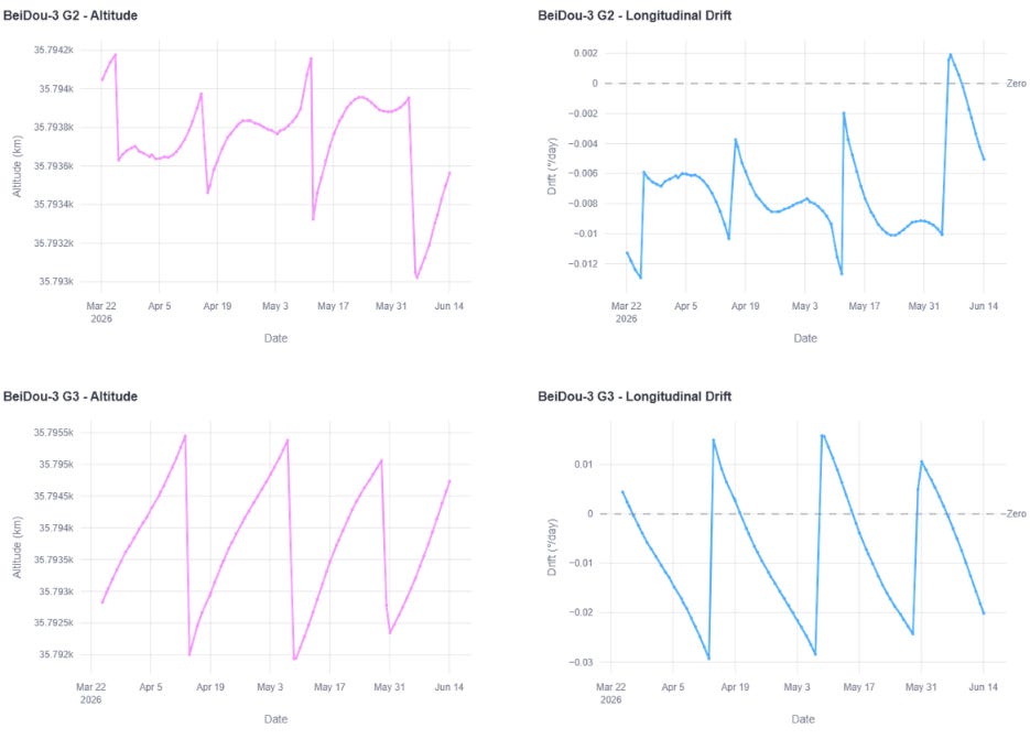
The operational takeaway is already clear from the orbital data and the official notification. China is not leaving its GEO satellites to drift quietly toward end-of-life. Slots are being actively managed, re-designated, vacated on schedule, and protected for future use.
IGSO: one weak satellite, strong geometry
The IGSO layer is less dramatic, but is still important. BeiDou-3’s IGSO satellites are designed to sit in inclined geosynchronous orbits with figure-eight ground tracks, improving high-elevation regional visibility over China and nearby areas. This is one of the reasons BeiDou’s regional architecture differs so much from GPS. A uniform MEO constellation gives broad global geometry. GEO and IGSO satellites add persistent regional presence.
The one weak point in our current monitoring is BeiDou-3 I1. Its inclination has drifted above the intended 55° target and is now outside the ±3° operational band we use to score health. We do not see a major inclination correction maneuver in the observed window.
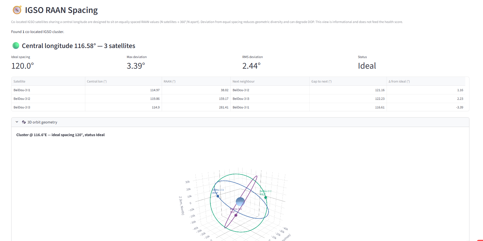
There are two possible explanations:
The benign interpretation is fuel conservation. The operators may be relaxing North-South station-keeping to extend the satellite's useful life, accepting some degradation in the figure-eight ground track — which reduces high-elevation visibility over Chinese territories of interest and widens the regional DOP gap during periods when I1 falls out of sync with the other GEOs and IGSOs.
The less benign interpretation is delayed maintenance or operational degradation.
Either way, I1 is the satellite to watch in the IGSO group.
The broader IGSO constellation, however, remains geometrically strong. The three BeiDou-3 IGSO satellites maintain near-perfect spacing in RAAN, roughly 120° apart. That spacing is a necessary condition for balanced regional visibility, but not sufficient on its own — inclination maintenance and true anomaly phasing also determine whether the satellites stay in sync and continue to fill coverage gaps as designed. Whether I1 requires additional phase-correction burns to maintain that sync with the other IGSOs remains worth tracking.
Conclusion: operational capacity is the difference
Technically speaking, BeiDou-3’s regional layer is healthy but also not static. G2 and G3 show disciplined GEO station-keeping. G1 and G4 show deliberate relocation, service upgrade and continuity management. The BDS-3 GEO satellites appear to be inheriting legacy BDS-2 slots, while the available BDS-3 IGSO satellites line up with the older BDS-2 IGSO family. Even in the weaker IGSO case, I1 looks less like a failure than an satellite to watch in an otherwise coherent regional geometry.
For NavIC: Tasked with giving India a sovereign regional PNT capability, it remains a small GEO/IGSO constellation with limited margin for clock failures, launch delays, and slow replacement cycles. BeiDou, by contrast, has moved from a regional system into a layered global architecture with MEO coverage, GEO/IGSO regional reinforcement, legacy-slot handover, and demonstrated lifecycle management through multiple means. The BeiDou system, to put it plainly, has more operational depth.
With this report, we officially launch the GNSS Health Monitor: a constellation-level live health dashboard. The dashboard tracks these systems as operational constellations, not just as satellite lists. Drill-down to understand attribution of low scores, ranging from station-keeping routines, drift and slot changes to plane geometry, and early signs of degradation or repositioning. Our methodology can be inspected here. The motivation for this effort was originally is to bring transparency to the general public on how the Indian NavIC system is faring. The effort has now been expanded to cover all similar constellations - mainly to help compare how NavIC is being operated against the others fielding such sophisticated space-based systems.
Next stop: MEO-based GNSS constellations.
Please reach out either through comments to this article, or in the feedback window on the GNSS Health Monitor if you have any suggestions, queries, or even (constructive) criticism that will help the team improve and cater to the transparency needs of users, operators, manufacturers, policy-makers and the tax-paying public.
Comments
Nothing yet. Say the first thing.
Sign in to join the conversation.