
Welcome to WeatherTiger’s continuing coverage of the 2026 hurricane season! If you’re a paid subscriber, as always, thanks for your support. You’ll find your subscriber exclusive Florida risk model output behind the paywall at the end of this newsletter, and can expect exclusive tropical threat bulletins daily through late October. Free subscribers, enjoy this complimentary seasonal outlook. WeatherTiger’s Hurricane Watch is a fully reader-supported publication, so if you like what I do, click below to upgrade your account and get the expertise you need to minimize your stress and maximize calm this hurricane season.
In 2026, the salads are trying to kill us[1]. The hurricanes? Not so much.
Not yet, anyway. As expected, it’s been the quietest start in the Tropical Atlantic since 2009, but mid-August nonetheless brings the “Sunday scaries” of hurricane season: an anticipatory dread just ahead of the typical timing of the most impactful storms.
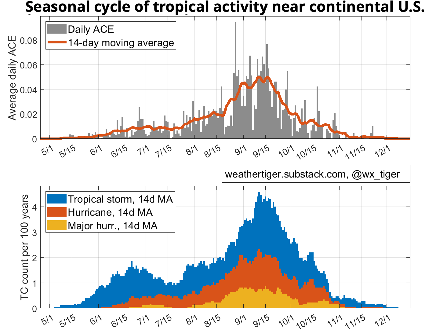
Today, I’m going to be assessing how U.S. landfall risks are shaping up for the late August through mid-October core of hurricane season, in which two-thirds of continental U.S. hurricane activity and 80% of U.S. major hurricane landfalls have historically occurred. But first, let’s discuss current Atlantic tropical activity, which is touching off a wave of jitters as visceral as if it was the night before school starts and you still can’t find a clear plastic binder for your summer book report on The Giver.
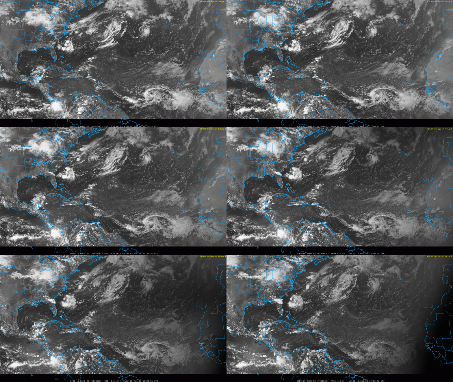
Things are perking up right on time, at least in a relative sense. As of Wednesday morning, Tropical Storm Cristobal became the third named storm of the season in the open waters of the Central Atlantic between Bermuda and the Azores. Cristobal is a weak, short-lived storm with no impacts on any land areas; of more interest is a tropical wave halfway between West Africa and the eastern Caribbean. This wave has some chance of becoming a tropical depression or tropical storm heading into the weekend, at which it time should be close to the Lesser Antilles.
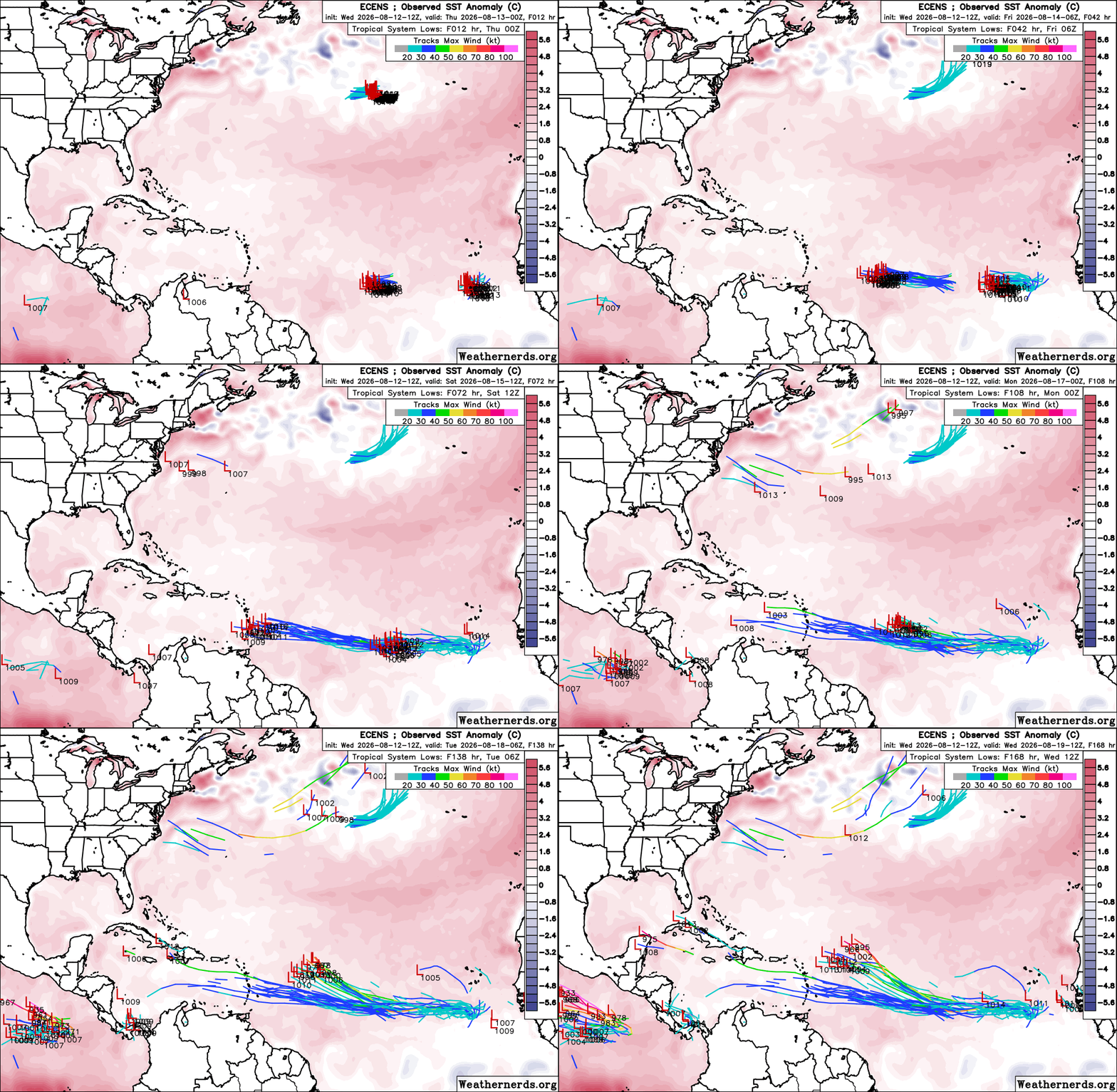
A potential tropical storm near the islands in mid-August is a classic set-up for something to watch in the continental U.S., but my concerns for Florida and beyond are nevertheless very, very low in this case. If it develops, the most likely outcome is that it continues westward into the Caribbean, where wind shear and dry air will rip it to shreds early next week. Alternatively, if the storm was to track a little more northwestward, it could get picked up by a dip in the jet stream in the west-central Atlantic and turn out to sea. Those are the main options as well for a second tropical wave closer to Africa that also has a chance of development this week, though odds tilt more toward a northward, open ocean track with that one if it organizes. I don’t see a realistic scenario in which either wave slips towards the U.S. as a coherent system, but as always, I’ll be watching them diligently and often, the way Wilford Brimley used to check his blood sugar.
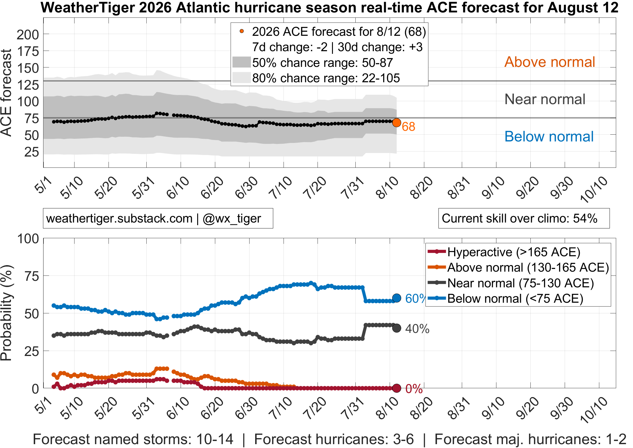
There are lessons for the season ahead in the fate of the current crop of storms and disturbances. It’s no coincidence that we find Cristobal and the gang in either the eastern half of the Tropical Atlantic or the subtropical Atlantic above 25°N. If you’ve read WeatherTiger’s previous 2026 hurricane season outlooks, you know I’ve consistently highlighted a developing El Niño and tepid temperatures in the Atlantic as key reasons why this season is likely to be much quieter than average in general. Those factors continue to hold, which is why our real-time forecast for total Atlantic Accumulated Cyclone Energy in 2026 is hovering around 65% of normal, with a ballpark of 3 to 5 hurricanes and 1 to 2 major hurricanes still ahead of us. There is a 60%+ chance of this year landing in the calmest third of seasons since 1950.
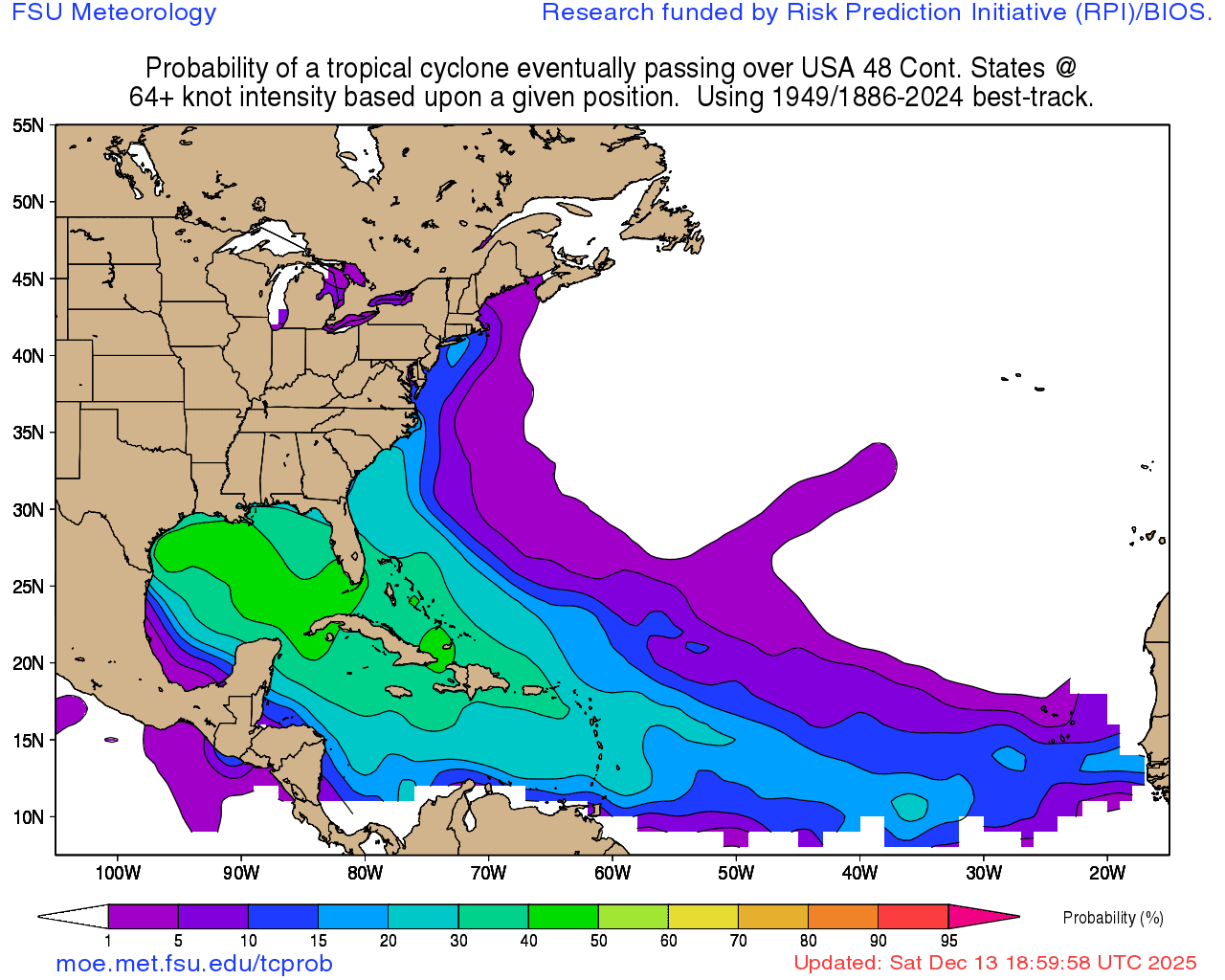
Of course, how many storms form is not what matters. Where hurricanes preferentially develop and move during the August-to-October peak season is what sets high-activity but low-impact years like 2023 and 2025 apart from a psychotic Crash-a-Rama like 2024. Logically, systems developing closer to the U.S. coastline have a better chance of making landfall; a random storm in the Gulf or Caribbean has a 30 to 40% chance of eventual U.S. hurricane landfall, while one in the eastern Tropical Atlantic has about a 10% chance. Cyclones in the central or eastern subtropical Atlantic, like Cristobal, never hit us and can be ignored for most intents and a majority of purposes.
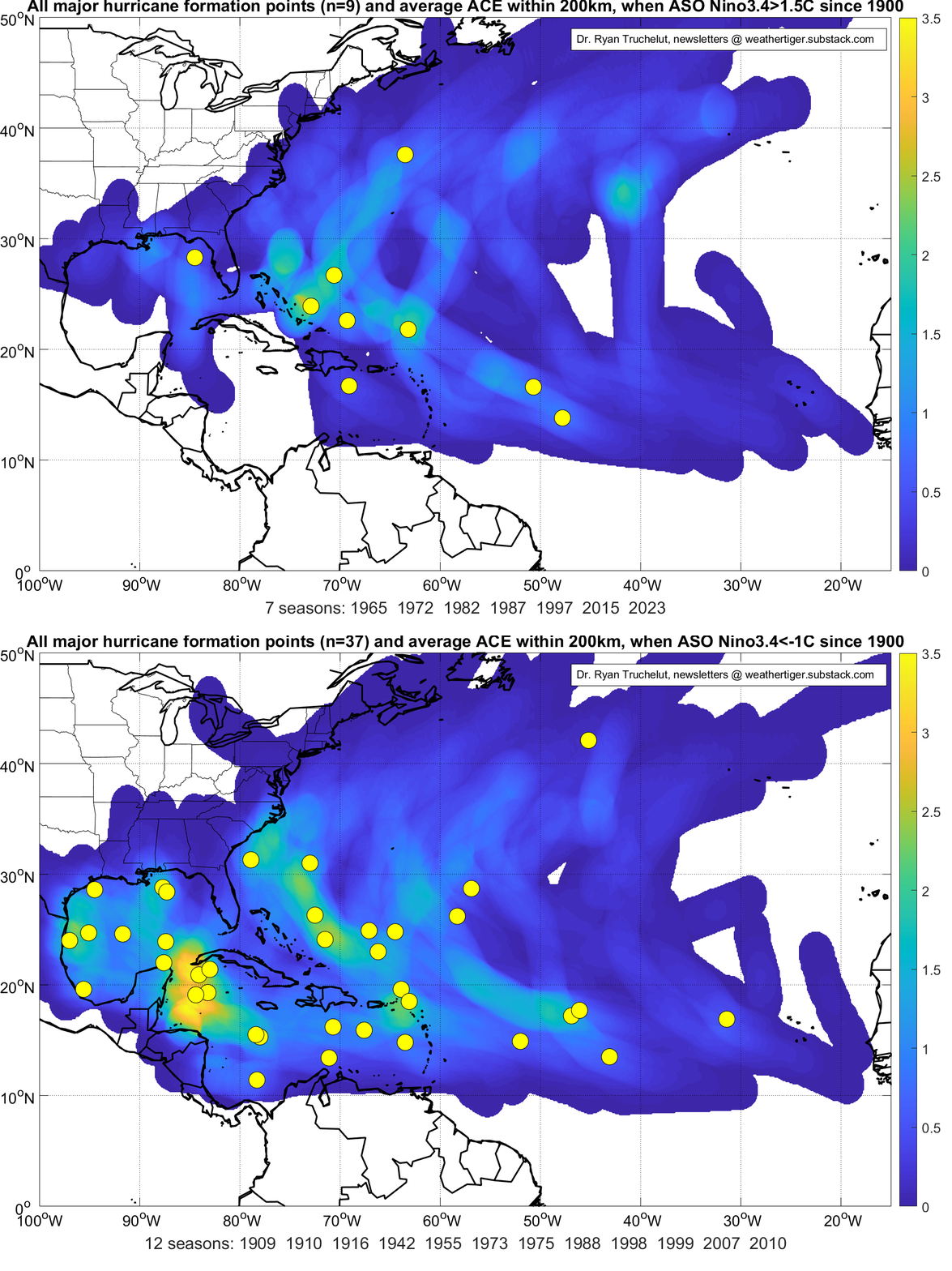
Among its profusion of impacts on global weather patterns, a historically strong El Niño event (read: sea surface temperatures in the Central Tropical Pacific well above normal) like the one rocking and rolling in summer 2026 shuffles not only how many, but where Atlantic tropical storms commonly form. With this El Niño going to extremes like Mr. William Joel and poised to become one of, if not the strongest Niños in the last 175 years, it has consistently produced a signature axis of violent vertical wind shear over the southern Gulf, Caribbean Sea, and central Tropical Atlantic this summer. In other recent strong El Niños, this shear has kept the southern Gulf and Caribbean mostly free of tropical activity all season long, as shown above.
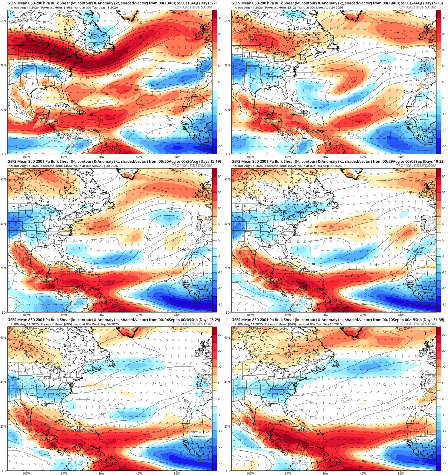
Thus, the fact that this week’s waves have a shot at development in the relatively hospitable (and warming) eastern Tropical Atlantic, but will either turn north or face annihilation in the Caribbean is likely a representative glimpse into September. I have every expectation these harsh conditions will continue; not only is there a strong historical tendency for elevated summer shear to persist through the peak of hurricane season, but long-range models unanimously forecast the wind shear to soon stiffen further as this Red Hulk of an El Niño rages on. That should be particularly helpful in late September and October, when the potential for monsters like Michael, Helene, and Melissa to form in the western and central Caribbean will be limited by unfavorable upper-level winds.
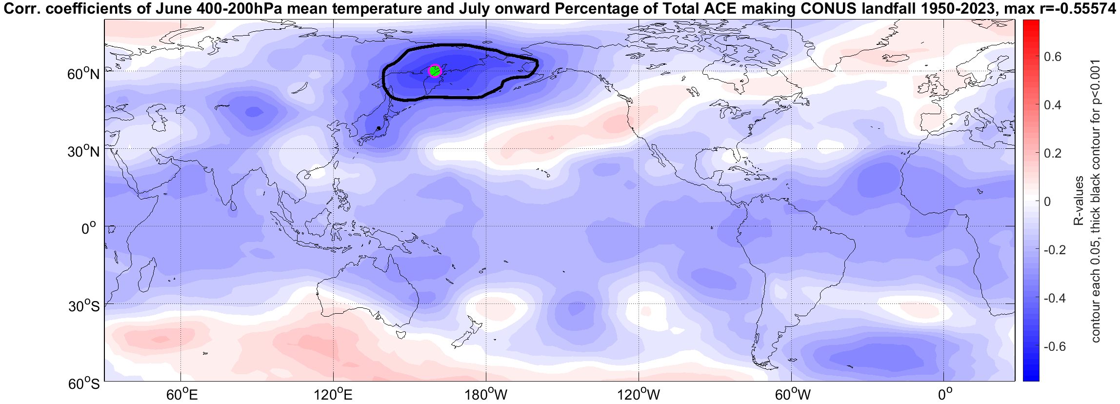
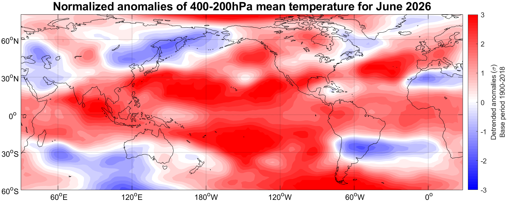
El Niño reduces U.S. landfall risks both through suppressing development, and causing the storms that do form to occur in places where there is a lower chance they ever reach land. The final pieces of the puzzle are the jet stream patterns that steer hurricanes, which are chaotic and defy efforts to be reliably predicted more than about 10 days ahead of time. Occasionally, there are signs that one steering pattern may be dominant over the next few months, usually linked to El Niño or mid-latitude signals like the Pacific Decadal Oscillation (PDO).
A warm PDO, warmer than normal waters from Alaska to California, makes high-pressure ridges over the western Atlantic more frequent, enhancing landfall risks by preventing hurricanes from turning north into open waters. This summer, an intermittent trough of low pressure over the North Pacific has caused a warmer trend along the U.S. West Coast, though a hot subtropical Pacific means the PDO is still in a cool phase overall. That means there’s not much of a steering signal either way in 2026. If a system manages to develop close to home in the Gulf or western subtropical Atlantic, or something beats the odds and escapes eastern Atlantic purgatory, how any potential threat shakes out will come down to luck and which way the wind is blowing at the time, as usual.
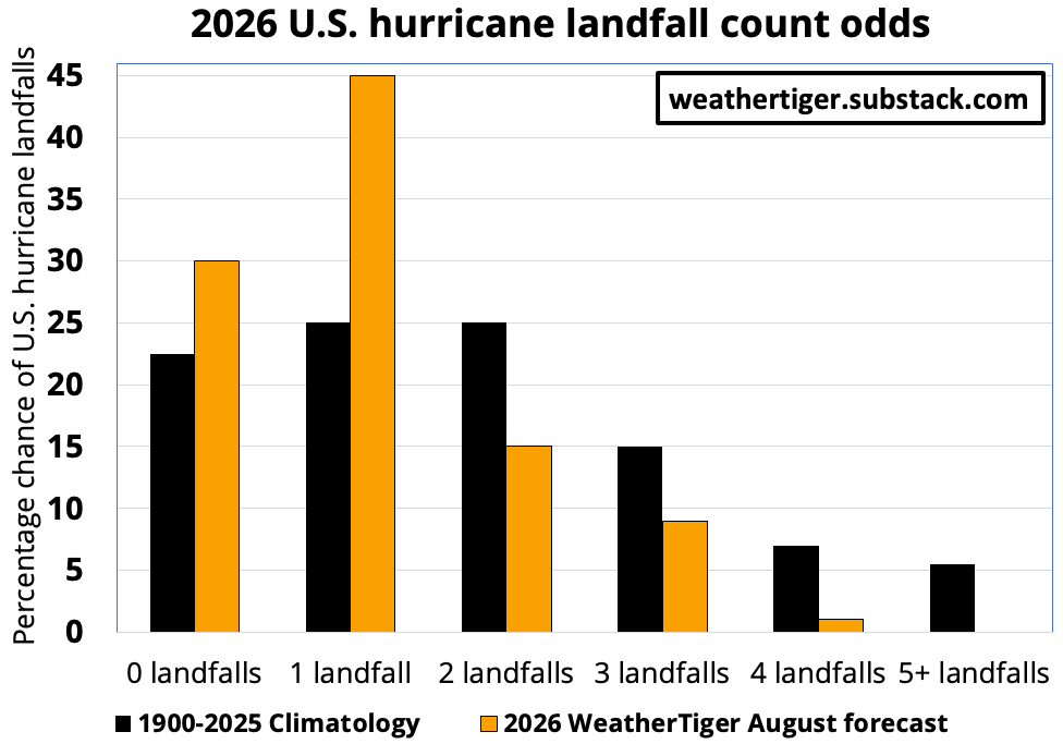
So, with about a quarter of hurricane season in impact terms behind us and only a couple modest brushes with tropical mediocrity to show for it, WeatherTiger’s U.S. landfall risk model projects that at least a couple more named storm strikes are probably still ahead of us in 2026, though odds of stronger hurricanes are significantly lower than in an average year. While there is around a 70% probability of at least one U.S. hurricane impact this season, the chances of two or more hurricane landfalls is 20 to 25%, compared with a whopping 75% chance in our August 2024 outlook. Most likely, we see just one U.S. hurricane landfall over the next few months, or none at all.
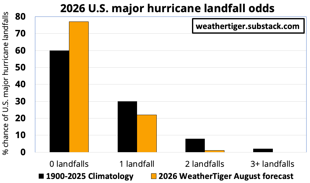
With the pathway to the Gulf Coast for powerful storms impeded by shear, risks of major hurricane strikes are diminished even further relative to norms. The odds of at least one Category 3 or higher U.S. landfall in 2026 are around 20%, versus an average chance of about 40%. There is almost no possibility of the double dose of major misery visited upon the U.S. coast in 2017, 2020, or 2024; the probability of two or more Cat 3+ hurricanes this year is around 1%, compared to a typical 10%. (Supporters, you can find specific odds for Florida’s 2026 hurricane landfall risks behind the paywall below, and daily updates to our U.S. landfall risk model here through mid-October. Machine-readable daily output from our storm and U.S. landfall count modeling for quantitative risk management decision support is also available via WeatherTiger Pro.)
So, it’s mid-August. The beautyberries are turning purple. Spirit Halloween is somehow already open. Objectively, this is the worst weather month of the year, usually for reasons including hurricane anxiety. This August will remain wretched due to staggering southern heat and drought, but my outlook for a clean-ish escape from hurricane season is cautiously optimistic—though everyone from Texas to Maine should always have hurricane kits and evacuation plans in place ahead of potential homegrown curveballs, no matter the long-range forecast. Still, in 2026, the salads may be nauseating, but the U.S. landfall outlook is chicken soup for the Floridian soul (and the souls of all coastal residents). Keep calm, and keep watching the skies.
[1] You don’t win friends with salad, just like Homer Simpson said.
Comments
Nothing yet. Say the first thing.
Sign in to join the conversation.