
WeatherTiger’s Hurricane Watch is a reader-supported publication. Paid subscribers get Florida-focused daily tropical briefings, plus coverage of every U.S. hurricane threat, our exclusive real-time seasonal forecast model, and the ability to comment and ask questions. And check out our WeatherTiger Pro service for market- and trading-oriented data solutions.
One of the traditions of the late Dr. Bill Gray—forefather of seasonal hurricane prediction and my great-great-grand-doctoral advisor—was ringing a bell on August 20 to mark the traditional beginning of the most active six weeks of hurricane season.
A core belief of mine is that Florida deserves a more culturally specific version of this rite of passage. Perhaps dumping some bath salts into the Gulf or releasing unwanted exotic reptiles behind a Waffle House might more effectively dispel ill winds from our fair shores. Whatever ritual one chooses to observe, that peak is here: over 60% of the Atlantic’s total hurricane activity occurs between August 20 and September 30.
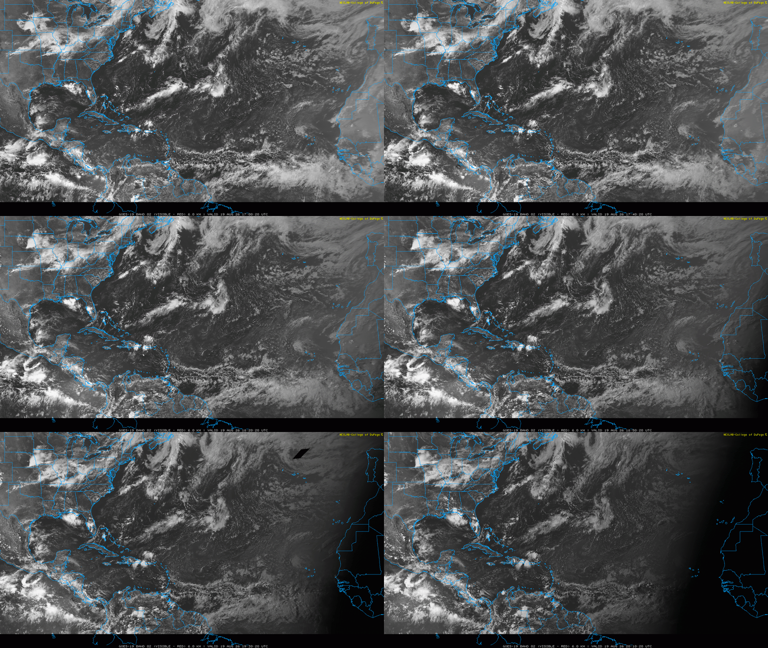
In 2026, the bell tolls for no one. This August 20, there will be no disturbances of note in the Gulf, Caribbean, or Atlantic, and tropical development is unlikely through at least August 25. As discussed in last week’s U.S. landfall risk outlook, the controlling factors are robust wind shear shredding tropical waves in the western half of the Atlantic Basin, and an arid airmass putting the kibosh on convection in the east.
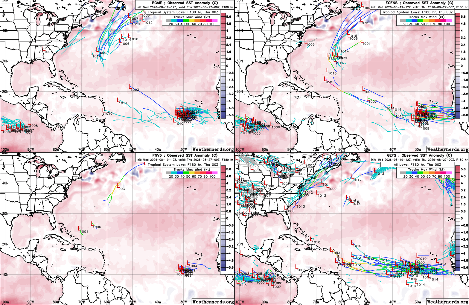
Entering the final week of August, that may change, though not in a way that puts the U.S. or other land areas at risk. A consensus of long-range models suggests that thunderstorm activity will be less limited by sinking air near West Africa in six to ten days, supporting possible slow organization of westward-moving tropical waves. Wednesday afternoon’s A- and B-tier model ensembles all have a healthy majority of members developing a tropical storm well east of the Lesser Antilles towards the end of next week, including around 65% of the typically skeptical Google Deepmind ensemble. That’s a long way off, but realistic given climatology and trends.
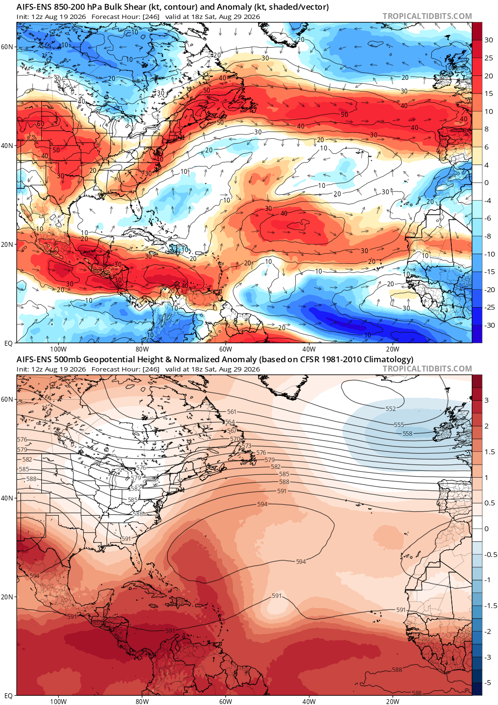
Even assuming eventual development, concerns remain minimal. That’s because the El Nino-induced wind shear from Central America to the Lesser Antilles isn’t going anywhere, and is capable of tearing a strong storm to pieces in days. If any systems dodge that shear by pivoting north of the Antilles, long-range models indicate a likely dip in the jet stream dip near the U.S. East Coast to end August and start September would probably turn anything north well offshore. Much like life itself, there are no guarantees in long-range tropical forecasting, but as of now there isn’t a realistic path for a U.S. landfall threat. There is also no indication of anything developing closer to home over the next week or two, though that can change quickly at this time of year.
The only thing we do know about the next named storm of the 2026 Atlantic hurricane season is that it will be named Dolly, and that I will greet it with copious sheep, Barbara Streisand, and even “Islands in the Stream” references. While 2026’s Dolly (the storm) is not likely to be an unimpeachable national treasure, it will join a long line of pilgrim Dollies stretching back to the beginning of regularly naming tropical storms in the mid-1950s. Flashback!
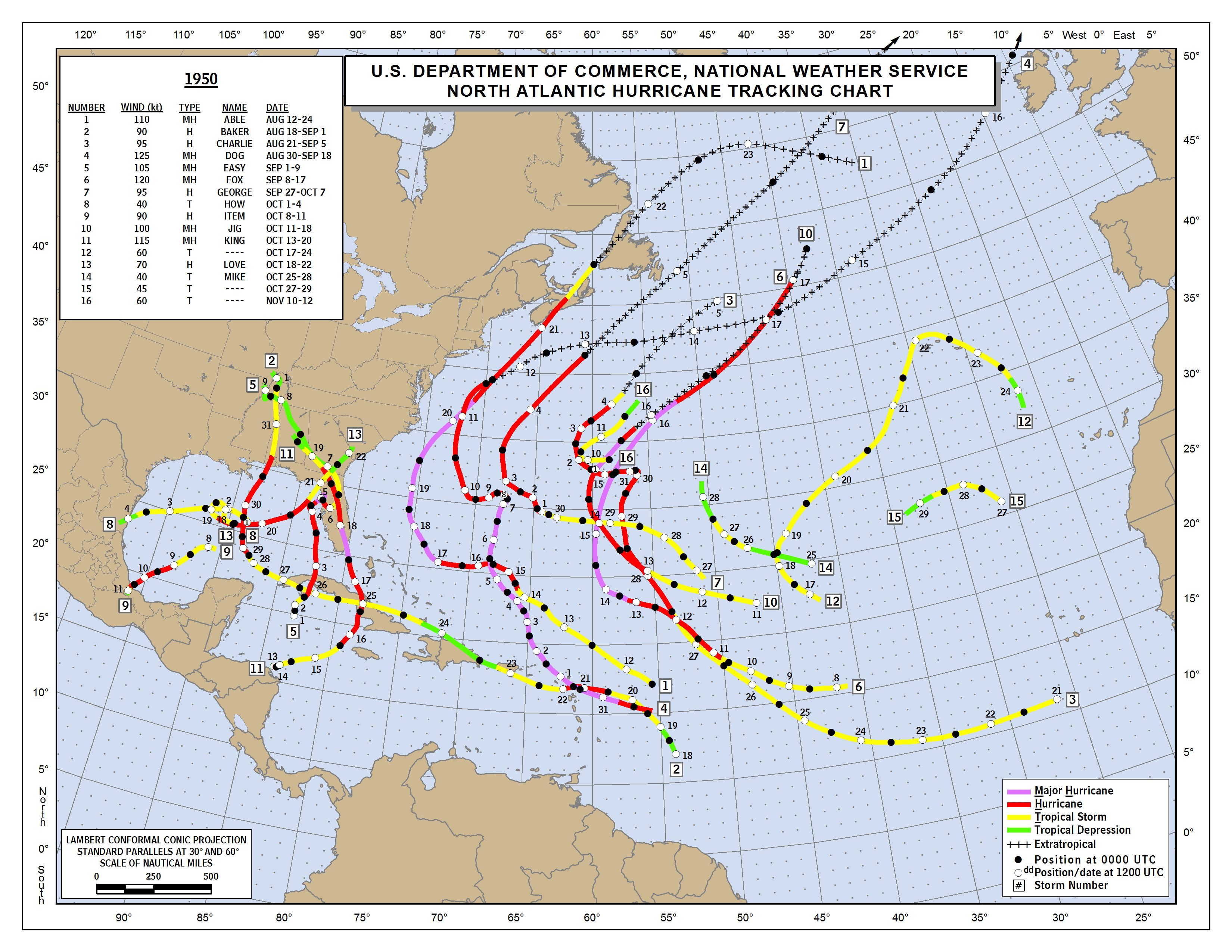
While landfall locations, religious holidays, and descriptive sobriquets (e.g., 1933’s “Yankee Hurricane”) have informally designated individual storms since the 1800s, the official naming of Atlantic tropical cyclones by the U.S. Weather Bureau began in 1950 with an annual repetition of the phonetic alphabet, following the practices of World War II military forecasters. Despite the comedic appeal of Hurricanes Dog, Easy, and King, the system proved confusing to the public and was replaced in 1953 by an all-female name list drawn heavily from the wives and girlfriends of forecasters and early Hurricane Hunters. In fact, Dolly was one of these original WAG, and its next use will be its tenth such iteration since 1953. That will tie Dolly for the second most cloned name (ok, starting a little early), trailing only the 12 instances of Arlene.
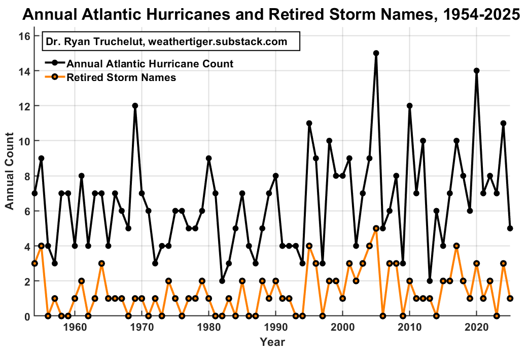
The precise names used each year through the 50s, 60s, and 70s varied somewhat unpredictably, though many repeated several times in that span. However, forecasters quickly realized that reusing the monikers of destructive hurricanes would be confusing and cruel, and thus informally “retired” the most infamous names between seasons. Starting in 1979, the World Meteorological Organization (WMO) assumed responsibility for managing Atlantic hurricane names, locking in a six-year rotation1 of 21-storm lists alternating men’s and women’s names that continues to be used today. Thus, if you mourn the brief candle that was last week’s Tropical Storm Cristobal, you can look forward to spending more time with a new Cristobal in 2032.
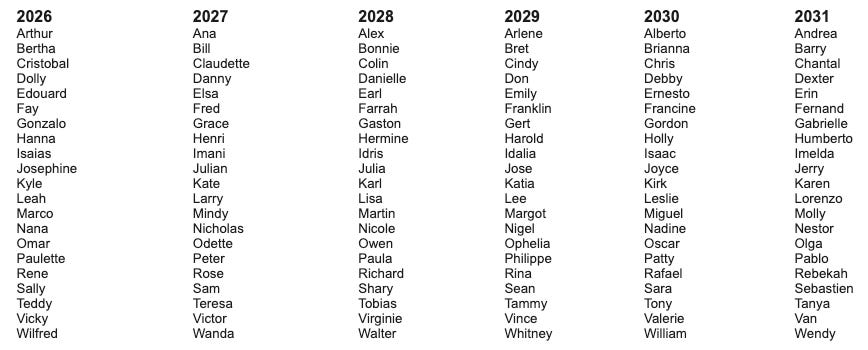
The WMO Atlantic region is beautiful tapestry of English-, Spanish-, and French-speaking nations, and there is an attempt made to balance the languages of origin on these lists. That’s probably for the best, though it is also how you get my desperate struggle to pronounce “Isaias,” which was easily the worst part of 2020. Note also that objective, scientific standards are used to assign names to disturbances, and as the most powerful and anthropomorphized weather phenomena, only tropical cyclones are officially named in the United States. (A variety of private forecast companies give impactful U.S. snow events unofficial names, including WeatherTiger, where we refer to every winter storm as Xtreme Iceblast Xenawarriorprincess for clarity.)
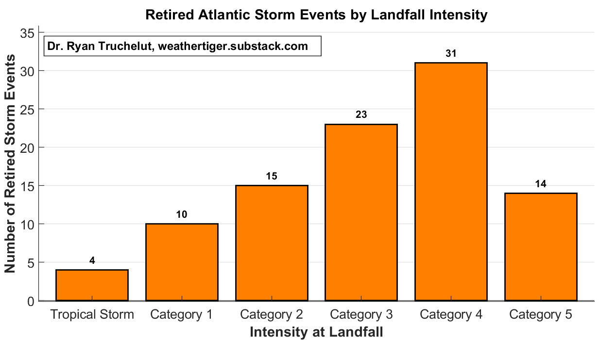
The WMO also manages the process by which hurricane names are removed and replaced. Following each season, each nation’s WMO representatives gather to coordinate their hurricane prediction and mitigation efforts. At this meeting, any country impacted by a storm in the previous year can formally request that name’s retirement, with a name of the same gender and letter then selected to replace it: i.e., Helene will be supplanted by Holly in 2030, and Melissa by Molly in 2031, possibly setting up a Holly-Molly-Dolly triple whammy in the early 2030s. Landfalling major hurricanes are most frequently retired, but Category 1’s or even tropical storms at strongest impact are well-represented amongst the 100 names removed since 1954. That points to the underestimated ability of freshwater flooding from “weaker” storms to nevertheless cause significant death and destruction.
Because retirement is a completely subjective process, it actually provides a unique perspective on risk distribution within hurricane season. The 100 names that have merited expulsion can in an imperfect sense be considered the “worst” storms in human impact terms since 1954, capturing information about societal vulnerability that measurements like Accumulated Cyclone Energy or landfall windspeed omit.
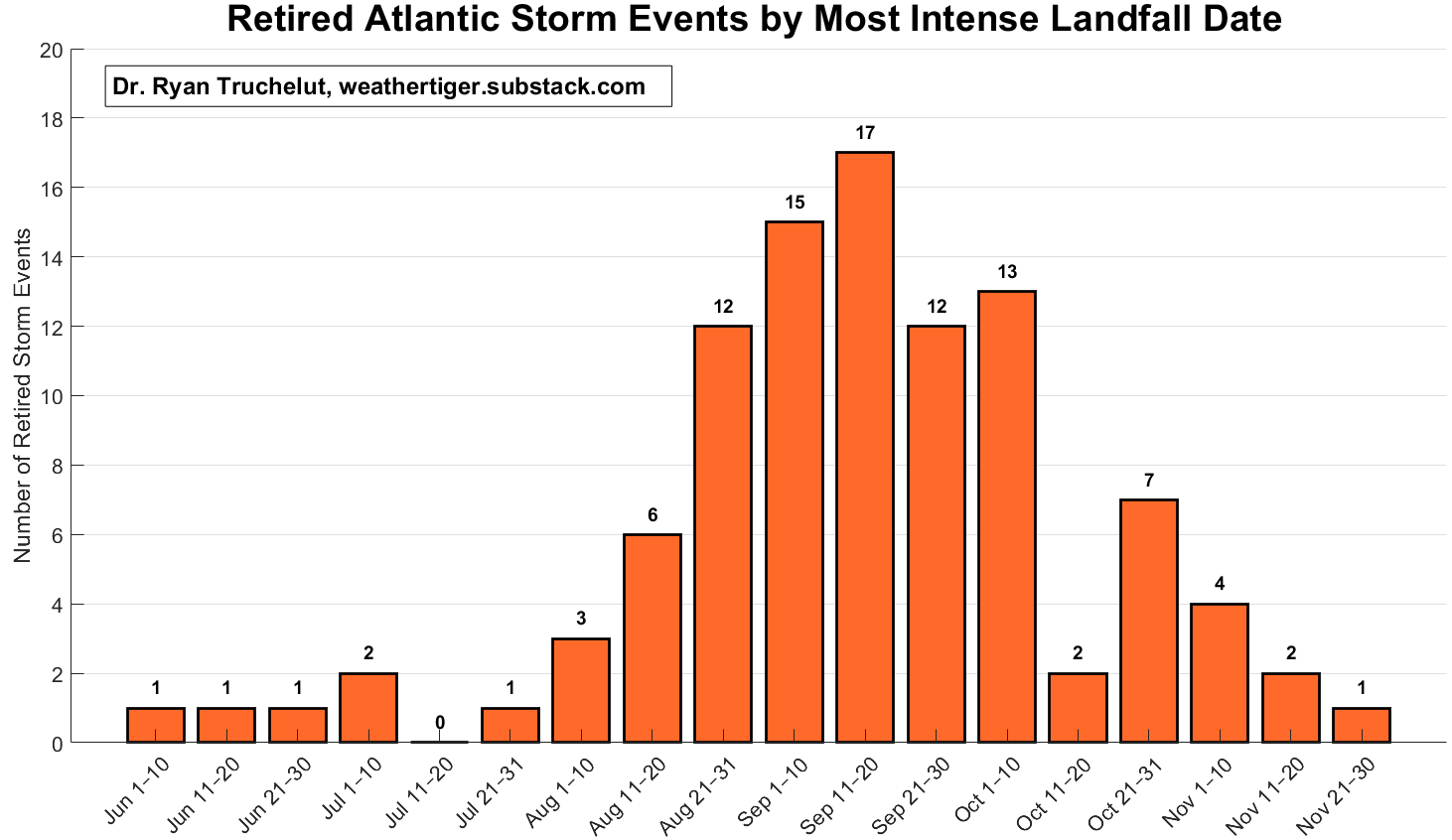
Those 100 worst storms across the Atlantic, Caribbean, and Gulf in the last 70 years, not surprisingly, are highly concentrated during the peak weeks of hurricane season, with a little less than 25% each occurring in August and October, and about 45% in September. So, in terms of historical big dogs, there’s still about 85% of the season left to go. As a final note, Florida is the state to most commonly bear the brunt of a retired storm’s strongest landfall, topping Louisiana and North Carolina by 50%. Turns out everything wants to retire to Del Boca Vista including hurricanes, though for some reason the cost of insurance keeps going up here.
So, this August 20, ring that bell, strike up the band for Tacobell’s Canon in D(oritos), or do whatever Santeria necessary to keep storms infrequent, offshore, and out of the retirement queue over the next couple months. No more than five additional storms would be great, because I really, really, really do not want to have to pronounce “Isaias” again this year. Keep watching the skies.
As of 2021, there is also a bonus seventh list of Atlantic storm names, in case more than 21 named storms occur during an Atlantic hurricane season. This replaced a Greek alphabet overflow system used in 2005 and 2020.
No posts
Comments
Nothing yet. Say the first thing.
Sign in to join the conversation.