
Although the Broadway and Cambie Plans envisioned substantial changes to land use along the Broadway Corridor and along Cambie Street, they did not actually change any land use rules. In Vancouver today, any land use change must be performed through a “rezoning”, a process which (over the course of 12-18 months) formally changes the land use rules of a parcel. What a plan like the Broadway Plan does is control what kinds of rezonings the city may accept. On September 16th, city council will hear a proposal to change the land use rules of many parcels in the Broadway and Cambie Plan areas to match what kinds of rezonings the Plans currently authorize. This is not an actual change in land use rules, but it does matter. For full details, see the referral report.
If you would like to comment, please do so here, and select “1. Standardized Apartment Districts and City-Initiated Zoning Changes to Implement Broadway Plan and Cambie Corridor Plan” as the agenda item. If you would like to speak in-person or over the phone, please do so here, and select “1. Standardized Apartment Districts and City-Initiated Zoning Changes to Implement Broadway Plan and Cambie Corridor Plan” as the agenda item.
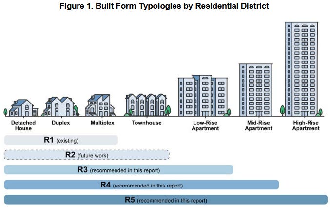
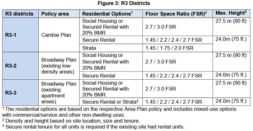
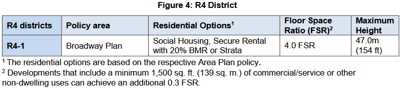
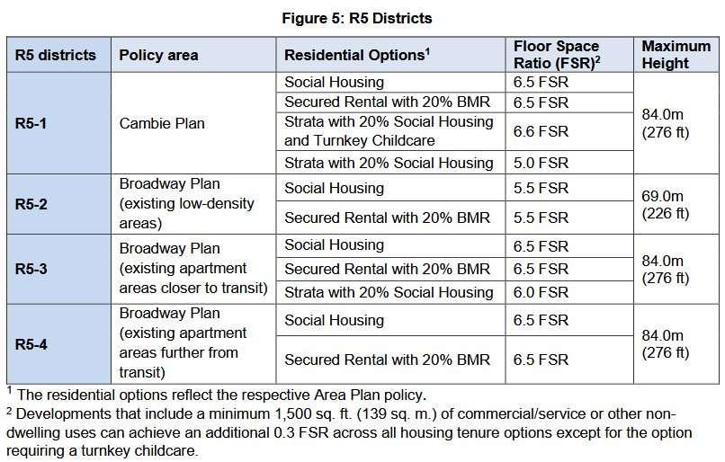
The proposal would create three new zone types: low-rise (R3), mid-rise (R4) and high-rise (R5). These zone types match the rules for what kinds of rezonings city council will authorize in the Broadway and Cambie Corridor areas. This rezoning would allow applicants to save 12-18 months of application time, and potentially millions of dollars of costs for larger projects.
Low-rise residential zones envision up to six storeys, generally as secured market rental, and often with a below-market housing option that grants additional density to the project.
The mid-rise residential zone allows a 12-storey building that is secured market rental with a below-market housing component.
The high-rise residential zone allows a 20-storey building that is secured market rental with a below-market housing or childcare component.
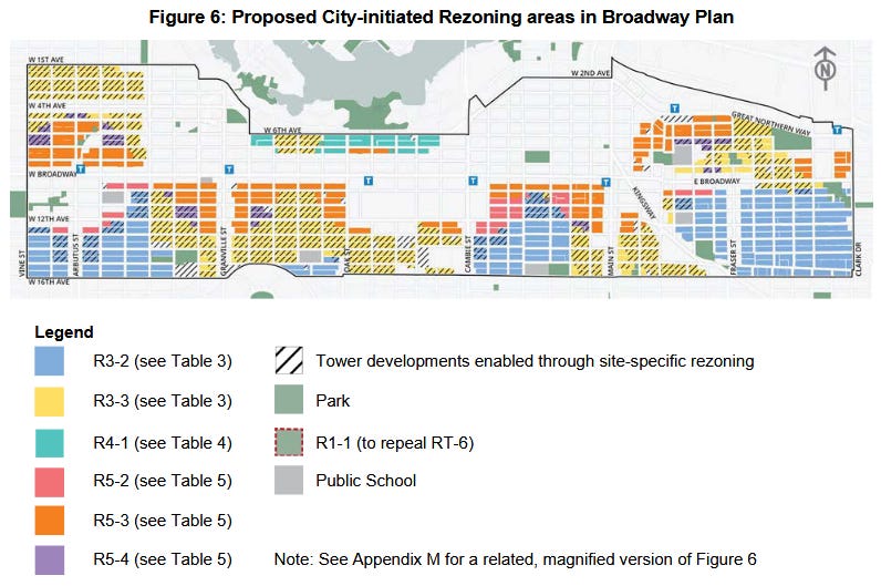
The Broadway Plan area rezoning map is below. This plan envisions by-right low-rise apartments throughout much of the area. Based on this map, it’s clear that R4 and R5 zones are only authorized in areas where Bill 47 forces the city to authorize higher than low-rise density.
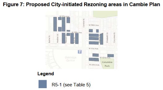
The Cambie Plan area rezoning map is below. Several sites are rezoned for substantial height and density due to the requirements of Bill 47. No other rezonings are present, indicating that the city is also only authorizing heights and densities where required by law.
Rezonings are a major source of uncertainty, delay and cost for new buildings, all of which get passed on to buyers and renters as higher purchase prices and rents. It will definitely help to reduce these burdens. However, the proposed heights and densities are likely not high enough to reliably pay for below-market housing requirements and the enhanced Tenant Relocation and Protection Policy (TRPP).
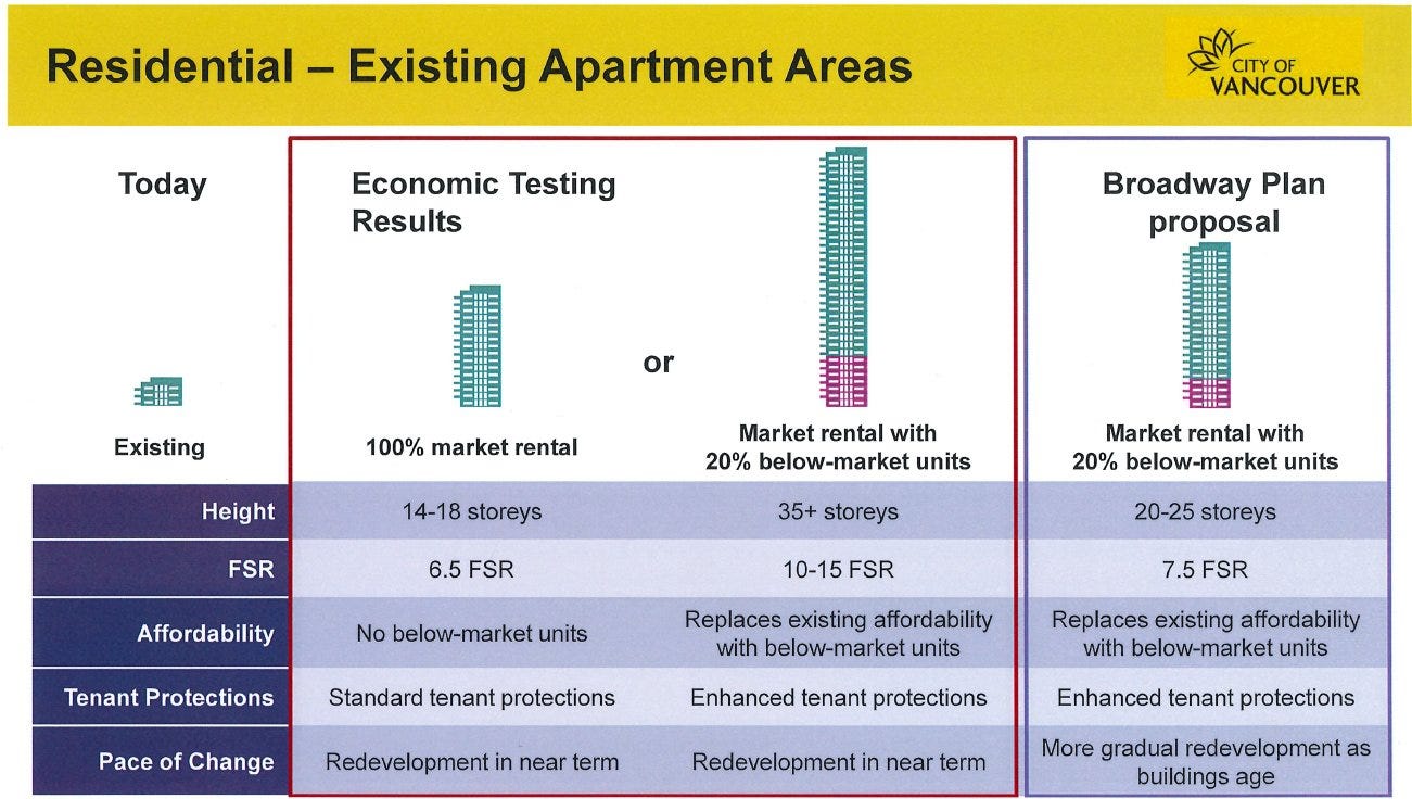
By only allowing heights and densities that are too low to pay for these benefits at current rents, the city is designing a policy that will apply only to a small number of the oldest buildings, unless rents increase. If rents decrease, even those older buildings could cease to be potential sites for new housing. The city could do more to ensure that the zones they have designed for this city-initiated rezoning will remain viable under a wide range of conditions.
No posts
Comments
Nothing yet. Say the first thing.
Sign in to join the conversation.