
Engage Louisa is a nonpartisan newsletter that keeps folks informed about Louisa County government. We believe our community is stronger and our government serves us better when we increase transparency, accessibility, and engagement.
For the latest information on county meetings, including public meetings of boards, commissions, authorities, work groups, and internal county committees, click here.
Monday, June 15
Louisa County Board of Supervisors, Public Meeting Room, Louisa County Office Building, 1 Woolfolk Ave., Louisa, 6 pm. (agenda packet, livestream)
Wednesday, June 17
Community Policy Management Team, Louisa County Office Building, 1 Woolfolk Ave., Louisa, 1 pm.
Board of Zoning Appeals, Public Meeting Room, Louisa County Office Building, 1 Woolfolk Ave., Louisa, 7 pm. (public notice)
Other meetings/events
Tuesday, June 16
Louisa Town Council, Louisa Town Hall, 212 Fredericksburg Ave., Louisa, 6 pm. (agenda packet)
Thursday, June 18
Mineral Town Council, budget public hearing, Mineral Town Hall, 312 Mineral Ave., Mineral, 6:30 pm. (agenda packet)
“Water is a precious commodity and should always be treated as such, but especially during drought conditions. Please do your part to ensure water resources are available for years to come.”
-Judson Foster, chair of the Louisa County Water Authority, in a press release last week announcing mandatory water restrictions for customers served by LCWA’s Zion Crossroads and Lake Anna systems. Read more below.
A segment of one of Louisa County’s busiest roads will close for six weeks starting this Monday, June 15, for road and utility work around a massive Amazon Web Services (AWS) data center campus.
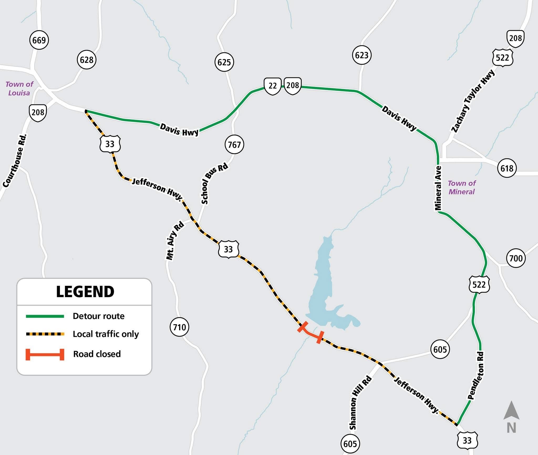
Louisa County said in a statement on Wednesday that a section of Jefferson Highway (Route 33) fronting the Northeast Creek Reservoir and adjacent to AWS’s North Creek Technology Campus will close from Monday, June 15, to Friday, July 31. A larger segment of the road, from the intersection of Route 33 and Davis Highway (Route 22) in the Town of Louisa to Pendleton Road (Route 522), will be limited to local traffic—motorists traveling to a destination along the corridor.
According to the county’s statement, contractors will perform a range of work during the month and a half closure, including installing a new culvert under the road “to mitigate historical flooding”; upgrading a domestic water main that will connect to a new pump station; and installing a modernized guardrail system to “improve motorist protection and reduce the severity of potential off-road incidents.”
The Virginia Department of Transportation’s (VDOT) Culpeper District Office said in a Facebook post on Friday that the work is taking place under a “special permit” and “associated with a private land-development project.” “[It’s] being carried out by their contractor, not as part of any state-funded VDOT maintenance or construction project,” the department said.
Louisa County shared a map showing the work zone and a detour route, which includes Routes 22 and 522 through the Town of Mineral. (See below)
News of the road’s impending closure came as a surprise to many community members. Residents who live on 33 found out about the closure last Monday when signs were installed in the Town of Louisa and near Cuckoo. Clark Construction, the general contractor for AWS’s data center campus, put up the signs, according to a VDOT spokesperson. Mineral District Supervisor Duane Adams, who represents much of the impacted area, also shared the news in a Facebook post Monday afternoon.
Neither Louisa County, VDOT, AWS nor Clark had publicly shared information regarding the closure prior to VDOT putting up the signs. That didn’t sit well with some community members, who sounded off on social media about the lack of information.
“So nice of them to give us a week’s notice, and they will be closing it for 6 weeks! This isn’t a small detour,” one resident said on Facebook.
Other community members voiced concern about how the detour would impact traffic on other roads.
“I expect traffic will be backed up from Louisa to Mineral. I can’t even imagine getting out of School Bus Road or Chalk Level [Road] going in [the] opposite direction,” one resident said.
Another commenter raised concerns about the impact on response times for Louisa County Fire and EMS.
“This is a huge hit on response times for fire/EMS and, in a forward-thinking system, leaders would redo the run order for affected areas. There are a lot of affected residents,” the community member said.
In its statement, Louisa County said that it aims to provide as much notice as possible on community projects. In this case, the county said that notification was provided “once all required permits and project components were finalized.”
The county emphasized that the work needs to be finished in the summer to avoid disruption to Louisa County Public Schools and that tackling the projects all at once “would minimize long-term disruption to the community.”
“The project plan balances execution speed with public safety to minimize impact on local traffic, schools, and residents,” the county said.
Regarding impacts on emergency services, the county said that the Fire and EMS Department is aware of the closure and the detour route.
“VDOT protocol requires direct coordination with Louisa County Fire and EMS prior to any road closure to ensure emergency personnel are fully informed of active detour routes,” the county said.
The road work appears to align with larger transportation upgrades AWS has planned for the sprawling data center complex, which is expected to be developed in three phases over the next 15 years. The tech giant has already submitted plans to the Army Corps of Engineers and the Virginia Department of Environmental Quality (DEQ) to build 18 data center buildings in the first two phases. It hasn’t revealed plans for the third phase.
According to a Buffer and Landscaping Plan provided to the county in late 2023, AWS intends to develop 816 acres of the 1,444-acre property while leaving 628 acres as open space. Of that, about 380 acres is expected to be donated to the county for potential use as a public park.
The company plans to build a public road through the site at its expense. Dubbed Green Bay Farm Road, the corridor appears to enter the campus just west of the Louisa County Water Authority’s water treatment plant, per documents submitted to the Army Corps and DEQ in 2025 as part of a permitting process required by the federal Clean Water Act. It will ultimately connect with Mt Airy Road (Route 644) near the southern end of the property.
AWS representatives told the planning commission in 2023 that the company opted to build a public road, as opposed to a private one, for several reasons. For one, the implementation of public roads impacts how the company can develop the campus based on state permitting requirements. Public roads are also a more practical option for reaching public park land and keeping construction traffic off Route 33 and Mt Airy Road, the company said.
Note: This story has been updated to correct an error related to who installed the road closure signs.
More news on data center development: Check out next week’s edition of Engage Louisa for coverage of a public hearing convened by the Virginia Department of Environmental Quality for a draft discharge permit for Amazon Web Services’ Lake Anna Technology Campus on Kentucky Springs Road (Route 652).
Check out Louisa County’s FAQ about the road closure here.
Amid dry conditions, the Louisa County Water Authority (LCWA) last week issued mandatory water restrictions for residents and businesses served by its Zion Crossroads and Lake Anna systems.
In a press release on Tuesday, LCWA said that “months of dry conditions, with very little rainfall, have caused the Green Springs / Zion Crossroads and New Bridge / Lake Anna Well levels to drop below normal levels for this time of year,” prompting the conservation measures.
“Mandating restrictions is intended to prevent shortages of safe potable drinking water for the County citizens connected to these public water systems,” the authority said.
LCWA taps public wells to serve customers at Zion Crossroads and Ferncliff, including Spring Creek, the Stonegate Apartments and surrounding businesses. It also relies on groundwater to serve customers along New Bridge Road (Route 208) near Lake Anna, including Lake Anna Plaza and surrounding townhomes.
The restrictions include limits on outdoor water use, including prohibitions on the use of sprinklers and irrigation systems, the washing of automobiles other than at a licensed car wash and the washing of streets and sidewalks and the exterior of buildings. The restrictions also prohibit restaurants from serving water unless it’s requested. (See below for more details).
Any violation of the mandatory restrictions will be enforced as a Class 3 Misdemeanor, per LCWA. A Class 3 Misdemeanor is punishable by an up to $500 fine.
“Water is a precious commodity and should always be treated as such, but especially during drought conditions. Please do your part to ensure water resources are available for years to come,” LCWA Chair Judson Foster said.
The restrictions don’t apply to customers who get water from the Northeast Creek Reservoir, a 187-acre surface water source, which serves the towns of Louisa and Mineral and other residents and businesses in central Louisa. The restrictions also don’t apply to residents with private wells though Louisa County earlier this month encouraged residents and businesses dependent on groundwater to “practice mindful water use.”
According to the Virginia Department of Environmental Quality (DEQ), most of the commonwealth is under a drought warning, meaning the onset of a drought event is imminent. In a June 11 Drought Advisory Update, the department said that, despite recent rainfall, “moderate and severe dryness persists statewide,” with soil moisture levels significantly below normal.
“Groundwater levels continue to decline and are expected to continue declining as summer begins and increased evapotranspiration, and higher water withdrawals impact well levels,” DEQ said. The agency noted that nearly all the state’s reservoirs are “within normal ranges.”
Water supply plans and concerns about data center development
LCWA’s announcement was met with a strong response on social media, mostly from residents concerned about the impact of ongoing data center development on the public water supply.
Amazon Web Services (AWS) is developing a pair of data center campuses in the county’s Technology Overlay District: one adjacent to the North Anna Power Station near Lake Anna and the other across the street from the Northeast Creek Reservoir in central Louisa. Both campuses will ultimately rely on water from the reservoir to cool their computer equipment, not the Zion Crossroads or Lake Anna wells.
AWS’s Lake Anna campus has one data center building that the company says has reached “substantial completion.” The campus is expected to rely on private wells for cooling until an 11-mile waterline to the reservoir is finished, likely by early 2027. AWS is paying for the line, but it will be operated and maintained by LCWA. The campus near the reservoir doesn’t have any data centers in operation.
County officials have repeatedly insisted that there’s plenty of water in the reservoir to serve the campuses, meet the needs of existing customers and accommodate future growth.
Economic Development Director Andy Wade has previously said that the campuses would tap the reservoir for, on average, 630,000 gallons of cooling water per day in the form of raw water that won’t be treated. The company is expected to use more than 7 million gallons per day at full buildout and peak demand. Wade has said that peak demand refers only to the hottest days of the year.
According to a capacity study conducted three years ago, the reservoir has a daily safe yield of 3.2 million gallons a day with current customers drawing between 300,000 and 500,000 gallons daily. Wade has said the study accounted for periods of significant drought.
It’s unclear what mechanisms are in place to ensure AWS doesn’t exceed any average daily water withdrawal threshold shared with the county.
The county’s third data center campus, EdgeCore Digital Infrastructure’s complex at the Shannon Hill Regional Business Park, will rely on water from the James River when its data centers go online. EdgeCore has submitted a site plan to the county but hasn’t started construction. The company has said that it will utilize a closed-loop, chilled water system to cool its equipment, which uses far less water than the industry standard.
The James River Project, which has been decades in the making and cost the county more than $60 million, is the long-term solution to water concerns around Zion, one of the county’s fastest growing areas. When complete, likely by the fall of 2027, the line will channel millions of gallons of water per day from the river to a treatment plant at Ferncliff then to residents and businesses along the Interstate 64 corridor. The infrastructure will relieve LCWA of its reliance on groundwater to meet demand in the area.
According to minutes from LCWA’s October 2025 meeting, the authority is eyeing additional infrastructure to serve customers at Lake Anna. Its board submitted a $5 million request to Louisa County to install a water tower off New Bridge Road and to drill a new well or wells. The county hasn’t included the request in its Capital Improvement Plan.
Mandatory Water Restrictions for LCWA’s Zion Crossroads and Lake Anna customers
No watering of outside shrubbery, trees, lawns, grass, plants, home vegetable gardens, or any other vegetation, except from a watering can or other container not exceeding three (3) gallons in capacity. No sprinklers, irrigation systems or any other method of outside watering. The only exception is for commercial greenhouses or nursery stocks, which may be watered to preserve plant life before 7:00 am or after 8:00 pm.
No washing of automobiles, trucks, trailers, or any other type of mobile equipment, except at a licensed commercial car wash facility.
No washing of sidewalks, streets, driveways, parking lots, service station aprons, exteriors of homes or apartments, commercial or industrial buildings or any other outdoor surface except where mandated by federal, state, or local law.
No operating of an ornamental fountain or other structure making a similar use of water.
No filling of swimming or wading pools requiring more than five (5) gallons of water, or the refilling of swimming or wading pools which were drained after the effective date of the declaration of emergency. There are some exceptions to prevent structural damage. Please contact the LCWA business office for additional information.
No fire hydrant use for any purpose other than County related business and suppression of fires.
No serving of water in restaurants, unless requested.
No operation of water-cooled comfort air conditioning that does not have water-conservation equipment in operation.
Any additional use restrictions as deemed necessary.
The Louisa County Board of Supervisors on Monday night will convene for its second June meeting with five public hearings on tap. Here’s a quick preview.
Supes to hold public hearing on CUP requirements for transmission infrastructure
Supervisors on Monday night will hold a public hearing and consider adopting an amendment to county code that establishes conditional use permit (CUP) requirements and performance standards for electrical transmission facilities.
The proposed ordinance would strengthen existing CUP requirements for substations and apply to all associated “switching stations, and related infrastructure for electric transmission lines operating at 69 kilovolts or greater,” per the draft. That includes new transmission facilities and expansions and modifications of existing facilities “that materially increase capacity and footprint.”
The proposed amendment wouldn’t apply to the transmission lines themselves. The power to approve large transmission lines and their routes lies with the State Corporation Commission (SCC) while localities, via local zoning authority, retain the power to approve supporting infrastructure.
Deputy County Administrator Chris Coon said in a memo to the board that though the suggested code changes come amid “regional discussions” of the Valley Link Transmission Company’s proposed Joshua Falls to Yeat transmission line, they aren’t tied to one specific project and would apply broadly to all future transmission infrastructure proposed in the county.
“As regional demand for electric transmission infrastructure continues to increase, localities are increasingly impacted by large-scale infrastructure proposals that can have long-term effects on land use patterns, rural character, and community development,” Coon said, adding, “The proposed amendment ensures Louisa County has a defined, transparent, and defensible process for reviewing transmission-related infrastructure, rather than relying on case-by-case determinations without established criteria.”
The Joshua Falls to Yeat project is a proposed 765-kilovolt (kV) transmission line slated to travel some 115 miles from just outside Lynchburg to southeastern Culpeper. Under development by the Valley Link Transmission Company, a partnership between Dominion Energy and several other utility companies, the project is designed to harness bulk power generated in the Ohio River Valley to meet burgeoning regional demand in Northern and Central Virginia, driven largely by data centers.
The line, the biggest ever proposed for construction in Dominion Energy territory, is slated to travel through Louisa for about 20 miles along one of two preliminary routes, slicing through farms and forests and passing just a few hundred feet from some homes.
The project has roiled residents and county leaders who’ve argued that Valley Link is sacrificing rural communities for economic development to the north. They’ve vowed to fight the project when it’s considered by state regulators. Valley Link is expected to submit its application and preferred route to the SCC this fall.
The draft ordinance articulates standards for electric transmission infrastructure, requiring applicants to demonstrate that proposed facilities comply with the county’s Comprehensive Plan; minimize impacts on adjacent properties and surrounding communities; and are compatible with existing land uses in its vicinity. They also require applicants to evaluate alternative routes, including using existing transmission corridors and co-locating within existing utility easements.
In addition, the standards include a provision related to buffering and setbacks, requiring “reasonable separation” from homes, public facilities and agricultural operations. The draft says that the board of supervisors would set minimum standards based on voltage.
The amendment also sets standards for environmental protection, like minimizing land disturbance, and requires a construction management plan, among other provisions.
The board at its June 1 meeting adopted an addendum to the 2040 Comprehensive Plan establishing preferred corridors for transmission lines and guidelines for the infrastructure. Among other provisions, the addendum prioritizes the use of existing right-of-way and utility easements for electric, gas, water and telecommunications infrastructure, public right-of-way along roads and “previously disturbed or developed linear infrastructure corridors.”
The addendum also encourages new transmission line corridors to avoid or minimize impacts on residential areas, agricultural and forestal lands, scenic and environmental resources, conservation easements and historic sites and recommends that developers underground the infrastructure when possible.
Coon said in his memo that the proposed CUP ordinance would operationalize the addendum.
“The Comprehensive Plan establishes policy direction, while the CUP ordinance provides the regulatory framework through which those policies are applied during project review,” he said.
Supervisors to hold four public hearings on additions to Ag/Forestal Districts
Supervisors will hold four public hearings to consider adding 1,803.8 acres to the county’s Agricultural and Forestal Districts (AFD). The hearings will cover landowners’ requests to expand the Gold Mine Creek AFD in northwestern Louisa by 253.6 acres; add 59.8 acres to the Trevilian Station AFD in western Louisa; expand the Shelton’s Mill AFD in the eastern end of the county by 157.5 acres; and add 1,332.9 acres to the Indian Creek AFD in south-central Louisa.
AFDs are a conservation tool that allow landowners to voluntarily prohibit development on their property for 10-year periods. In return, participating parcels are assured enrollment in the Use Value Taxation program, colloquially referred to as “land use.” The program places a special assessment on land used for agriculture, horticulture or forestry based on its “use value,” instead of its fair market value, translating into substantially lower tax bills.
In addition, AFDs place restrictions on local governments’ ability to enact ordinances that “would unreasonably restrict or regulate farm structures or farming and forestry practices,” per state code.
VDOT to present quarterly report
A routine quarterly update from the Virginia Department of Transportation (VDOT) might be the marquee item on Monday’s agenda, thanks to a surprise announcement of a major road closure.
Louisa County residents last week found out that a slice of Jefferson Highway (Route 33) near Amazon Web Services’ North Creek Technology Campus will close for six weeks, from Monday, June 15, to Friday, July 31. (See article above).
The closure will allow private contractors to install a modern guardrail system along the roadway and to upgrade a culvert and replace a water main that run beneath the road. The road work hasn’t been publicly discussed at recent board of supervisors’ meetings.
Residents along Route 33 and other community members were notified of the closure last Monday when signs were posted in the Town of Louisa and near the intersection of Routes 522 and 33 at Cuckoo. Mineral District Supervisor Duane Adams also shared the news in a Facebook post Monday afternoon. That was followed by about 24 hours of silence from the county as residents pressed for more details.
After publicly acknowledging the closure on Tuesday, the county provided a map with a suggested detour route and other information late Wednesday afternoon.
The slow rollout of project specifics and the limited public notice are likely to be topics of discussion during the update.
The presentation will also serve as an introduction to Craig Simpson, the new resident engineer for VDOT’s Louisa Residency. Simpson is filling the job previously held by Scott Thornton who last month took another position with the department.
Simpson previously served as the assistant district traffic engineer for VDOT’s Fredericksburg District, where he oversaw traffic engineering studies and safety projects. Before that, he worked in the Warrenton Residency as both an assistant resident engineer for land use and as a land use engineer, per a VDOT press release.
In his new role, Simpson will oversee highway maintenance and operations, land use, and emergency response for more than 3,100 miles of state-maintained roads in Louisa, Orange and Fluvanna counties. He’ll helm a staff of more than 79 employees and serve as the department’s primary liaison with local government officials.
An Orange County resident, Simpson holds a bachelor’s degree in civil engineering from Virginia Tech and a master’s degree in engineering management from Old Dominion University.
The Louisa County Planning Commission on Thursday continued a discussion about potential changes to the zoning code aimed at slowing residential growth, preserving agricultural land and protecting the community’s rural character. (meeting materials, video)
At a work session prior to its regular meeting, commissioners and county staff focused on changes that would limit by-right residential development in the county’s eight designated growth areas and lower density thresholds.
Deputy County Administrator Chris Coon pitched the proposals as a way to facilitate a Transfer of Development Rights (TDR) program that would allow landowners with property in agricultural areas to sell their development rights to folks looking to increase the density of a project in a growth area, effectively channeling growth to where the county wants it. Coon also emphasized that putting additional guardrails on growth within the areas designated for it would help ensure the community’s infrastructure and services can keep up.
The proposals are part of a larger growth management strategy being crafted by the commission and county staff, most notably Coon and a two-man work group comprised of Cuckoo District Commissioner George Goodwin and Mountain Road District Commissioner Todd Hicks.
The board of supervisors tasked the commission earlier this year with identifying ways to slow residential growth, especially in the county’s agricultural areas where new homes are usurping farms and forestland and, some say, threatening the community’s rural character.
Over the last five years, the county has ranked among the five fastest growing localities in the state based on percentage of population growth, a statistic that has alarmed county leaders and community members alike. According to staff, more than half of the roughly 430 homes the county’s adding each year are built in rural areas.
County leaders have also insisted that residential growth is ballooning the budget, a consequence of an increased demand for services and strains on infrastructure.
“Without change, residential buildout occurs by-right, service demands continue to increase and then the preservation goals become harder to achieve as we move forward,” Coon said in a presentation to the commission on Thursday.
The commission last month heard details of the first phase of a potential plan to curb new home construction on agriculturally zoned parcels outside of growth areas, in part, by limiting new parcel creation. Staff has identified the creation of new parcels—essentially dividing or subdividing larger tracts of land—as a key indicator of future growth and emphasized that it fragments farmland, making it difficult to continue agricultural operations.
In an effort to limit the number of new parcels and, in turn, slow growth, the work group floated upping the minimum lot size for new parcels in A-1 and A-2 zoning outside of growth areas from 1.5 acres to as many as 15; increasing road frontage requirements for new lots from 200-300 feet to 450; and hiking setback requirements for new and existing lots to push new homes farther off the road.
Alternatively, the commission discussed establishing both a minimum and maximum setback, which would limit residential development to a small band near the front of a parcel, theoretically preserving the rear for agriculture.
Coon has said the proposals would help curb new home construction by limiting divisions and, depending on what setback method was adopted, help ensure large swaths of farmland are still viable. They would also preserve rural character by pushing homes away from roadsides and farther apart.
Amid criticism that the proposals would raise the cost of housing at a time when affordable housing is scarce and strip landowners of their property rights, the work group has emphasized that the potential changes are one piece of a larger growth management plan, which aims to channel growth into areas that can support it and potentially offer denser and more affordable housing options. The plan would also include components to incentivize landowners to preserve their property by offering them a way to realize economic value elsewhere.
That’s where a TDR program would come in, which the work group touched on at Thursday’s meeting and will delve into more next month. Coon described the program as a market-centered approach to land preservation in which landowners with property in agricultural areas could sell their division rights to developers hoping to pursue projects in growth areas, essentially limiting future development on the rural parcel while directing growth where the county wants it.
Following procedures laid out in state code, Coon said the county would establish sending zones, where division rights could be sold, and receiving zones where developers could buy them, with the former encompassing property in rural areas and the latter taking in land in growth areas.
As Coon described it, property owners with land in a sending zone who want to sell one or multiple division rights that they hold by-right would notify the county. They’d then be placed on a list that would be provided to developers interested in acquiring division rights and could sell them if they chose.
Coon noted that if a landowner didn’t like a project, they could opt not to sell their development rights, effectively giving rural landowners leverage over what’s developed in growth areas.
To help facilitate the program, the work group pitched increasing the minimum lot size in residential zoning inside the county’s designated growth areas from 1.5 to 2.5 acres with additional density possible via TDRs.
“Instead of granting the higher density of 1.5 acres in R-1 and R-2 [zoning], it would be 2.5 acres. But if they purchase development rights, then they could get back to the 1.5 acres…That means the parcel that they purchased it from [in the rural area] can divide at least one less time depending on how many [division rights] they purchased,” Coon explained.
In addition, the work group proposed lowering the residential density permitted in a Planned Unit Development (PUD), from a maximum of 10 dwelling units per acre (DUA) to a base density of .75 DUA while allowing for more density through the TDR program and/or by offering affordable housing, preserving open space, upgrading infrastructure or providing other public benefits identified by the county. PUDs require approval by the board of supervisors.
Coon said that lowering base density, while offering avenues to increase it, provides a mechanism to manage growth and ensure that developers address community needs.
“If somebody comes in the door with a 100-acre parcel, they can build 75 units right out the gate [with an approved PUD]. But, depending on what they’re willing to contribute to Louisa County, the higher the benefit, the higher density they’d be able to get. That’s something that we’ve also talked about—making sure people cover their impacts,” Coon said.
But Coon acknowledged that decreasing by-right density would effectively increase housing costs if nothing else is done. He suggested that the ability to ensure housing costs don’t skyrocket and the county is able to support more diverse and affordable options, like apartments and townhomes, hinges on the success of the TDR program and density bonus initiative. That means monitoring the programs closely should they be adopted and tweaking them when necessary, he said.
Hicks and Goodwin agreed.
“If you’re going to slow growth, one byproduct is going to be increased cost per unit. It’s pretty hard to get away from that, but we’ve established and put in here enough variables that we can watch what’s going on and [make changes]…If the market is not acting the way we want it to act, we can take a look at those incentives, increase or decrease depending on how things are reacting,” Goodwin said.
“I don’t believe that [slowing growth and preserving rural character] lowers the cost of housing. When we are preserving rural character, we are making availability less so the natural reaction to that action is the cost goes up…Implementing [strategies like the TDR] into it gives us the possibility for affordable housing that many say does not exist right now,” Hicks said.
Hicks urged patience with the process and noted that the county would likely need more staff to administer a TDR program and ensure its successful.
The work group also floated ideas to balance commercial and residential growth. Coon noted that the county has attracted far more new homes than businesses in recent years and struggled to find ways to ensure that developers who promise to bring commercial and residential space deliver the former in a timely manner.
To achieve a better balance, the work group suggested requiring Planned Unit Developments to be mixed-use and tying the number of dwellings permitted to the amount and type of commercial space.
As an example, Coon said that 10 dwelling units could require 4,000 square feet of commercial space while 100 could require 40,000 square feet. In addition, the work group recommended issuing no more than 25 percent of the certificates of occupancy for residential units until the commercial development is delivered.
“I think we all can agree that we have a substantial amount more homes than commercial entities right now,” Coon said, noting that the commercial component of the PUDs would be designed to create a complete community that could limit vehicle trips by providing local services and employment opportunities alongside residences.
It’s unclear how this proposal would work with the density bonus initiative and whether it would stymie developers’ ability to effectively deliver diverse and attainable housing options. Based on market factors, developers could have difficulty attracting commercial entities, for example.
Coon said the county would have to closely monitor its commercial requirements to ensure it hasn’t erected hurdles that developers can’t clear.
At a work session next month the commission will take a deeper dive into exactly how a TDR program could work and how companion preservation programs, including what county staff has called a “termed” Purchase of Development Rights (PDR) program, might operate.
Agricultural Development and Land Conservation Coordinator Maggie Brakeville has pitched the latter program as a mechanism to preserve farm and forestland in the near and intermediate term and potentially serve as a bridge to permanent conservation easements. Under the program landowners would agree to forgo development on their property for a set period and, in exchange, receive compensation from the county.
Coon and commissioners have said that their goal is to provide a comprehensive growth management plan to the board of supervisors for consideration, which accounts for rural preservation, growth management and affordability.
Hicks emphasized the importance of public involvement, noting that the commission is considering significant changes to the rules that dictate what property owners can do with their land, and they need feedback from those who live here and would be directly impacted.
“This is a big deal, and everybody should be highly focused on it,” he said.
Any changes to the zoning code would require public hearings in front of the planning commission and the board of supervisors and an affirmative vote by the latter body.
Other business
In other business, the planning commission at its regular meeting held three public hearings and recommended the board of supervisors expand the Green Springs, Ellisville and Gold Mine Creek Agricultural and Forestal Districts by a combined 427 acres. (meeting materials, video)
During their work session, commissioners continued a discussion of how to define “campground” in county code as the use has become a de facto way to provide housing to workers in the county for temporary jobs. Check out an upcoming edition of Engage Louisa for more on that topic.
Click here for contact information for the Louisa County Board of Supervisors.
Find agendas and minutes from previous Board of Supervisors and Planning Commission meetings as well as archived recordings here.
Click here for contact information for the Louisa County School Board.
Click here for minutes and agendas for School Board meetings. Click here for archived video.
Click here to access past editions of Engage Louisa.
No posts
Comments
Nothing yet. Say the first thing.
Sign in to join the conversation.