
This article applies the trigger point methodology to a public case: Alberta’s boreal fire regime. As with Tehran, the Peneda-Gerês and the Vinalopó, the aim is to read the system breaks, locate the couplings that still hold, and find the points where a small input propagates into recovery. The principle carries across any coupled hydrological-ecological system that has degraded without yet crossing an irreversible threshold.
Most fire stories begin with a drying climate. This one, however, cannot, because Alberta’s climate, measured the ordinary way, has not dried.
Total precipitation across the province is flat. Rain intensity is flat. Annual streamflow in the near-natural basins is flat. And the variable that ought to settle the matter, the count of dangerous fire-weather days, the hot-dry-windy afternoons that fire scientists tally directly, shows no significant trend at nine of ten long-record stations across the boreal and oil-sands belt (1980–2025).
Set against that: 2023 burned more of Canada than any year in the observational record. 2025 rivals it. 2011 and 2021 sit close behind. Alberta’s burned-area record is not a rising line. It is a short list of enormous years.
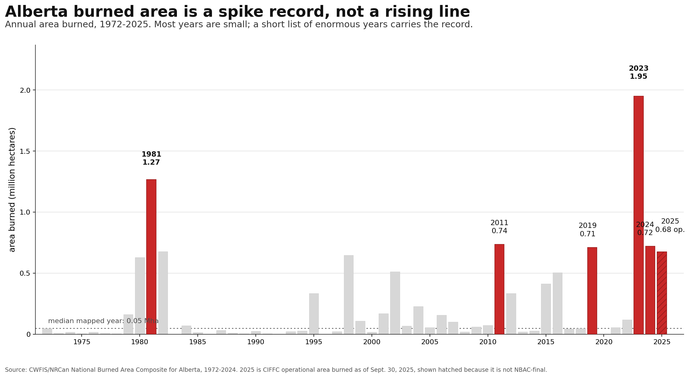
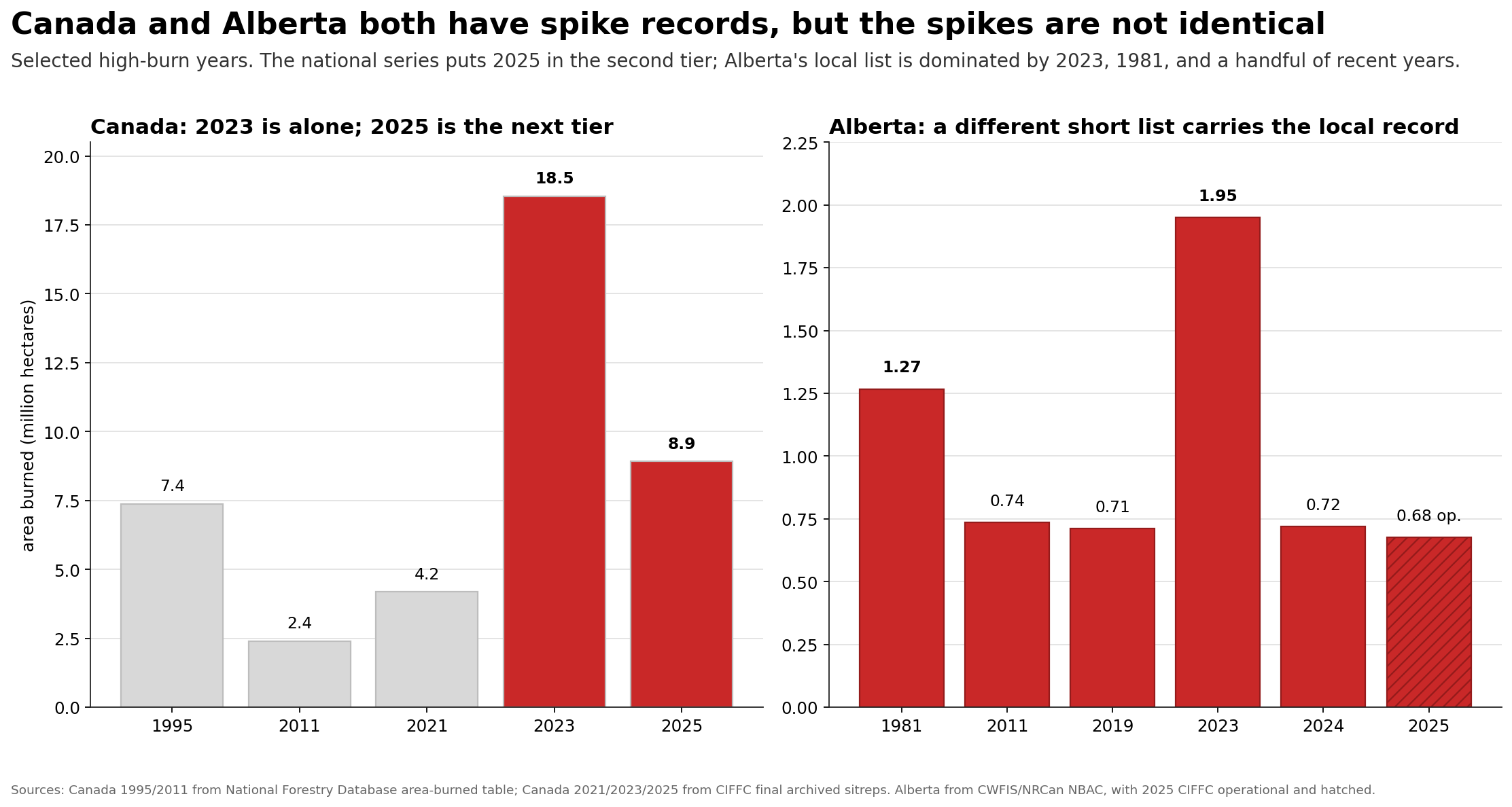
A flat climate and a worsening fire regime are supposed to be incompatible. but in a wet boreal environment they are not, and the reason they are not is the entire diagnosis. The water cycle did not break on average. It broke at its tails and its seams, and fire is the one hazard that lives entirely in the tails and seams the averages cannot see.
That distinction matters because it corrects the larger Alberta water story. The diagnosis here is not that Alberta is simply drying out, or that the province has crossed into a permanently water-poor climate. The broader tests point the other way. Rain totals are not collapsing. Rain intensity is not rising into a new monsoon-like regime. Near-natural anchors such as the Crowsnest still hold their long record within a stable envelope. The water cycle is still supplying water.
What changed is where that water can be held.
In the south, the old prairie-pothole and grassland sponge has been converted into one of Canada’s highest-value farm belts: roughly $84.6 billion in farm capital across the irrigation census divisions, about 45% of Alberta’s farm assets. On the surface the belt is green because water is imported, stored, allocated, and applied, not because the prairie became a naturally wet landscape.
The South Saskatchewan system is almost fully committed: about 4,369 million cubic metres a year allocated against a ceiling near 4,400, with roughly 71 percent of committed use in irrigation. In an ordinary year that system can look stable.
In a paleo-class drought, which the tree-ring record show has already happened in 1550s and earlier, the gap becomes roughly 1.4 to 1.7 billion cubic metres, enough to force irrigation cuts on the order of 45 to 56 percent under the stress-test assumptions. That is pressure without a rainfall collapse or water cycle collapse.
The same is true on the flood side. Drain the prairie-pothole surface and the land does not lose the rain; it loses the ability to keep it. Roughly 64 percent of settled-area slough and marsh wetlands are already gone. In the dose-response literature, 50 percent drainage cuts depression storage from about 125 to 81 mm, and near-complete drainage more than doubles flood-relevant runoff. So a May-July burst that once ponded, infiltrated, or recharged the shallow system becomes water delivered too fast to the channel. Flood and drought are not opposites here. They are two symptoms of the same lost holding function.
The mountain edge adds a third version of the same mistake. The clean headwater warning is not a simple decline in annual precipitation. At Crowsnest, the live signal is phase and timing: more water arriving as rain rather than stored snow, with the natural flow envelope still broadly holding. Converted lowland surfaces can also change the air’s boundary-layer behaviour, raising cloud base and fuel dryness along the path, but the defensible claim is narrower than “the Rockies stopped getting rain.” The lever is timing, phase, storage, and condensation height, not a provincewide rain failure.
Now and here is the most critical part, when we carry the same logic northwards. We reach the boreal forests, which are naturally fire-prone, and were never a wet machine that could not burn. What held them was the wet brake: saturated fen peat, flood-pulse recharge, peat/forest evapotranspiration topping up dangerous air, and low ignition density in intact wetlands. Oil-sands roads, pads, ditches, seismic lines, and dewatering do not have to dry all of Alberta to matter. They only have to lower the water table or convert the surface at the ignition point. On the worst afternoons, warm Pacific/ridge air arrives already thirsty; peat and forest can moisten it, cropland cannot; drained fens can ignite. That is the through-line: the water cycle still works, but the land no longer always holds water in the places and hours where holding is the difference between buffering and combustion.
Stated at the province scale, it is one diagnosis wearing two faces. Drain the prairie sponge and the south floods; drain the boreal fen and the north burns. Too much connection in the first, too little holding in the second, both the same buffer failure read in opposite directions. Water security here is a question of timing and holding, not of how much rain falls, and that is the sentence the rest of this piece spends on the northern face.
Comments
Nothing yet. Say the first thing.
Sign in to join the conversation.