
The theory is that Lehi landed on the tip of Baja, and the Nephites and Lamanites moved north from here, and are the main ancestral population of the Uto-Aztecs. Baja is the land of Promise of the Book of Mormon.
Their web page is https://achoiceland.com/ with many well written articles and David Rosenvall recently made a guest appearance on Stick of Joseph:
I’ve read about 80% of their articles.
This theory has a lot more going for it than I expected. In the end it has some problems and doesn’t quite match. I feel it could be though without God massively re-arranging things, and the only other place for which that could be said is North Chile/Peru.
1. There is gold, silver, copper ore here.
2. The climate is almost right. With a little more rain it would be paradise for the Mediterranean agriculture package as the land of promise is depicted. Its plausible that there was more rain during BoM times, and the current aridity was part of the curse on the land when they rejected Jesus.
3. It’s isolated from the stuff going on elsewhere in America but could lead to a diaspora and the Lehites being an ancestral group of native Americans. I really dislike the theories where Nephites are a drop in a bucket of indigenes.
4. The shape, including one river is correct. I note they tend to rotate Baja in their maps, so it runs straight up and down instead of slightly to the side as in north-south oriented maps. I was expecting the narrow neck to be more like a chokepoint, but I suppose it’s within the reading.
5. The arguments that the land depicted in the book of Mormon is fairly dry and without major rivers are convincing. They also argue that there was more rainfall in Book of Mormon times, without considering what the River Sidon (Rio San Ignacio) would look like under those conditions, let alone other possible waterways.
6. In the video the guy mentions genetic links between dates and olives in baja and those in Oman. That could be a clincher, but I’d want to see the Institute they referenced findings, and what a plant geneticist thinks about this. It may be nothing after all, like the X haplotype around the Great Lakes.
They’ve followed up on the Book of Mormon was translated around 1600 theory and use Oxford English Dictionary definitions from that time period.
borders: geographical demarcation, could be mountains
curious: skilled, complex
fountains: spring or small body of water
isle: a small island or peninsula
round about: an arc or circle of a central feature
both: more than one, not necessarily two
They have helpful list of words they suggest using a 1600 Oxford English definition: barges, by times, chariots, curious, dearth, destructions, flatter, fevers, flocks, fruit, great (cities), highways, isle, machinery, marvelous, measure, mighty (cities), mists, morrow month, reckon, sakes, serpents, signs, silks, sojourn, tarry, thrash, timber, towers, vapors, waters, wilderness and wonders
I’d already gotten the gist of some of these words, but its nice to have it in writing in an official source.
1. It feels very cramped to me. Everything is much closer than I’m comfortable with. For example, in the Great and Lasting War two and occasionally three fronts are depicted. With the geography proposed you would have the different armies being 3-4 days march from each other, which in the historical examples I’m familiar with leads to armies coalescing into one for obvious reasons. (The corps system is a notable counterexample, but its purpose was for foraging. In the G&L war they were relied on supply lines.)
2. They rely on Brian Stubbs work on Uto-Aztec and Semitic + Afro-Asiatic similarity to suggest that Uto-Aztec language family represents the post Book of Mormon times diaspora. This is wrong because they go much further than Stubbs who is only arguing evidence of significant contact, not that Uto-Aztec descended from Book of Mormon languages. As for his theory, one should keep in mind that he is comparing cognates from multiple languages to proto Uto Aztec and Nahua which multiplies the number of cognates needed to make a convincing case.
3. Ruins, especially of high roads and fortifications. There are some, but the walls shown are not the large earthworks with robust stone on top of them I’d expect. The roads are cleared paths (broad to be sure) but not built up higher than the surrounding terrain I would expect with the 1600s word ‘highway’
4. Found animals, grains, and fever remedies - Vague, other than suggesting that we ought to count animals found in La Brea tar pits, which includes elephantids, camelids, and lots of other species generally thought to have been long extinct by Book of Mormon times.
5. Ocean currents - the route for Jaredites makes sense. The route for the Nephites is vague. The truth is if you are starting at Oman with inexperienced mariners and navigators that don’t know how to tack &c, so you would want to stick with prevailing currents and winds, the best way to get to the Americas is head south to the westerlies, which will take you quickly and naturally to the S. Pacific American Coast. The natural strongest current in the ocean is east to west winds on the equator (Trade Winds) and west to east winds near the poles (the westerlies). Oceans in the N. Hemisphere thus tend to have a clockwise whirl and oceans in the south have a counterclockwise whirl. From Oman you follow the E→W trade wind til it gets close to Africa where it will head south because of the continent. Then you pick up a westerly near the pole which takes you south of Australia and New Zealand until you pick up the northward current running along the west coast of S. America. The “roaring fourties” were first used in 1611, halving travel time from Europe to Java. From the Middle East to S. America was not a common route during the Eurocentric age of sale but a north Chile landing site would not be difficult for a ship “running the easting down” starting from Oman.
Their proposed route Baja California is against the trade wind, then through unknown straits, islands, and shoals, not to mention pirates and potentially hostile natives (Close reliance on the Liahona would have been essential, and something Nephi would have mentioned). But once you break into the North Pacific, then yes baja would be a natural landing site.
God could have overruled nature and arranged so the current and winds were behaving in unusual ways to make this voyage happen. In my opinion God only overrules nature under specific circumstances for specific purposes and generally wants us to know that he is doing it. God loves nature, I bet he would just go off autistically about the 2 million beetle species he created if he had time and ran into a fellow enthusiast. Whatever corner of nature you sperg out on, I’m sure God was there sperging out on it before you (Abraham and the Stars). Or as GK Chesterton speculates he is like a little child who seeing the sun rise excitedly shouts again, again, do it again and enjoys the millionth iteration as enormously as the first, while appreciating variations on the theme of a light fog, or crisp dry air, or some dust suspended in the air. The song Morning has Broken really captures this, and I quite enjoy the Cat Stevens cover.
I see I’ve wondered off topic, so I guess I have said everything I had to say on the Baja theory. Let’s bring this to a close.
I ask myself why I, and others, are drawn so much to trying to find the BoM lands. I think it is threefold:
Proving it or at least having something much more plausible than current theories, would remove the shame and ridicule we sometimes face from the world for believing something which appears ridiculous to them.
A desire to have all branches of knowledge fit together well and reinforce each other. I realize that scientific and historic critique is the wrong frame to evaluate religious truth, but it seems to me that truth ought to circumscribe into one whole, and I have faith that it will, even if we cannot do that in our current state. That said, this exercise tends to sharpen the understanding of geography, history, agriculture and such. It is a hook encouraging learning.
A hope that upon proving it, others would then convert. Part of me wonders how non-believers would react if we got not just a likely setting for it, but undeniable proof. But we see Jesus doing miracles in the New Testament, but him mostly rejecting the kind of belief that that inspired. OTOH, a lot of the converts during the meteoric rise of Christianity in the first few centuries of our Lord cited witnessing miracles as the reason for their conversion, so it’s not as if this motive is entirely wrong.
I suppose if God wanted to prove not just the Book of Mormon but his own being, he would. And I belief that he will, but for the purposes of this life to be fulfilled it is better we live in ambiguity. And he ultimately will allow or not allow proof of the Book of Mormon to come forth, according to his own purposes.
Understand the stories in the Book of Mormon better. Knowing the map and distances has an effect on some of these things. I would love to know the general aesthetics too.
A day after publishing this I ran into an argument that God is intending to reveal BoM geography to good effect at the right time: David Whitmer’s Prophecy About Book of Mormon Geography
Something that has stuck with me for a while is one of th articles lamenting how we can’t just plug in latitude and longitude to find out where the promised land was. Then the site turns around and does just that in other articles.
Latitude - this is given based on the assertion that the fact that seeds grew abundantly, all from Israel and possibly Arabia. It meas that they were in a very similar climate. Assuming the Book of Mormon geography may have been drastically re-arranged in the cataclysm 33 AD recounted by the book, we’ll ignore the fact the Mediterranean type climates seem to typically occur on a west coast.
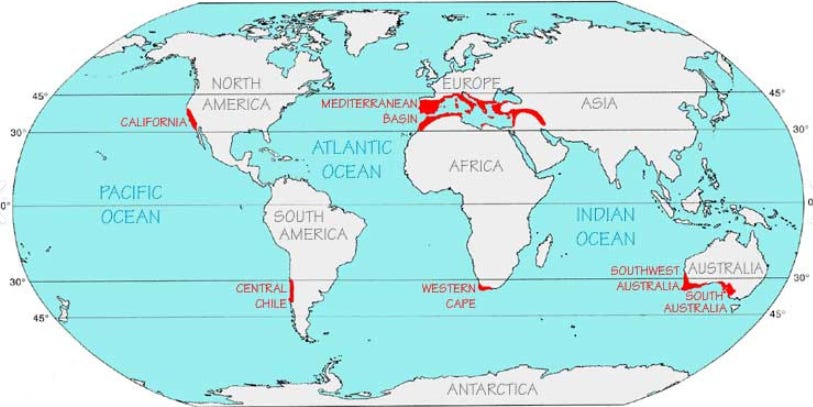
Since Israel and Arabia are on the hotter side, I’m going to go with lower boundary here and say the landind site (Land of First Inheritance) is probably around 30 degrees latitude +/- 5 degrees. The rest of book of Mormon lands are north of this location. I’m going to discount possibilities such as they are in a tropical area but at a higher cooler elevation because the account does not mention any further traveling after landing, and I think having to journey through a sweltering jungle to higher elevations of what was supposed to be a ‘choice land’, would have been sufficiently faith trying to merit attention in Nephi’s account.
I note the description of all the seeds flourishing abundantly without mention of pests or weeds hindering their progress implies they are acting like invasive species which makes it likely they are in a smaller landmass, and not close to an area where large scale agriculture is (or was) taking place.
Longitude - To calculate this we take an event that happened simultaneously in the Old World and in the Land of Promise, as pointed out in the website. This is the crucifixation of Jesus Christ, which happenened around 3 PM in Jerusalem*, which is reported to have been followed shortly afterwards with the sun darkening and an earthquake which tore the veil of the temple in half. *The ninth hour = nine hours after sunrise, which is roughly the hour between 2:30 and 3:30 PM.
In the Book of Mormon lands the death of Christ was signaled by storm and violent destruction.
20 But behold, as I said unto you concerning another sign, a sign of his death, behold, in that day that he shall suffer death the sun shall be darkened and refuse to give his light unto you; and also the moon and the stars; and there shall be no light upon the face of this land, even from the time that he shall suffer death, for the space of three days, to the time that he shall rise again from the dead.
21 Yea, at the time that he shall yield up the ghost there shall be thunderings and lightnings for the space of many hours, and the earth shall shake and tremble; and the rocks which are upon the face of this earth, which are both above the earth and beneath, which ye know at this time are solid, or the more part of it is one solid mass, shall be broken up;
Helamen 14
And its reported that there were three hours of storm, and then darkness fell, but in the prophecy both started at the time of his death. So he died three hours before dawn, and the darkness was only noticed after dawn failed to come. So the land of promise is 12 hours before the promised land.
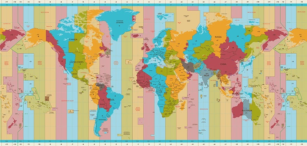
This gives us the first green and second yellow zone from the left of this map. Eastern Polynesia. I suppose you could make an argument that these have the places where natives recieved the book of mormon as expected based on the prophecies in it, (I consider the S. America miracle to mostly have taken place among the more European descended, so a subset of that gathering.) Jacob did say they were on an island of the sea. And they did liken the words of Isaiah unto themselves focusing on passages that talked about the islands of the sea, which is a good description of that corner of the world.
The topography doesn’t match, but it is in a tectonically active region. Perhaps once Samoa and Tonga were part of a larger island like New Zealand that has since sunk beneath the sea.
Or perhaps I should recheck my assumption. If we say the notice about darkness falling just means it happened during daylight and that is when he died, and the storm is before that, say when he was sentenced to death, then we are nine hours before. That puts us in Northern Mexico- CA time zones. That looks good for baja, and an fairly empty region of the South Pacific that sit on an underwater ridgeline with only Easter Island. I have to consider the amusing possibility that the Land of promise has since sunk beneath the waves except for Easter Island.
The underwater topography looks roughly like an H laying on its side.
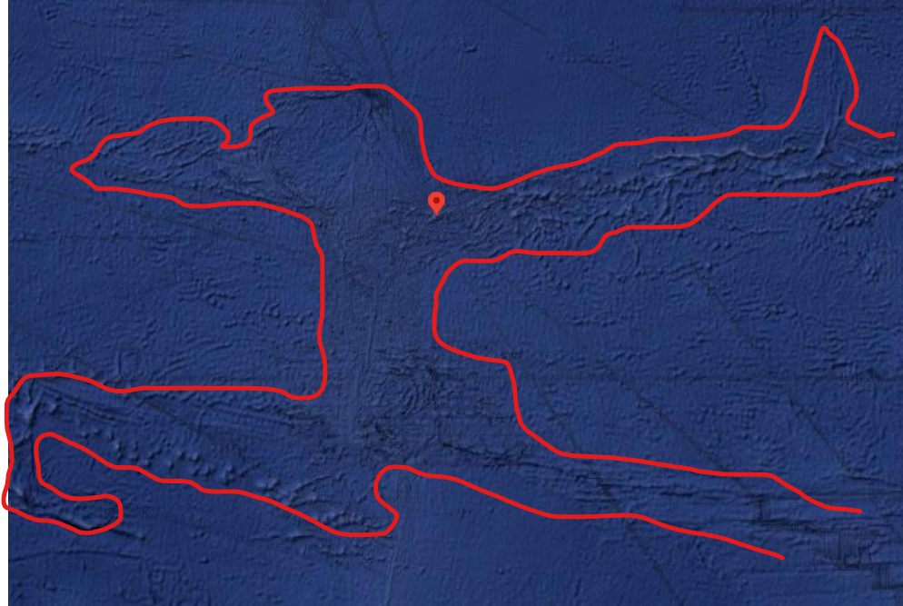
Not what I was expecting the land of promise to look like but more like than many models I have seen.
A lot rests on my assumption of what “at the time of his death” means.
No posts
Comments
Nothing yet. Say the first thing.
Sign in to join the conversation.