
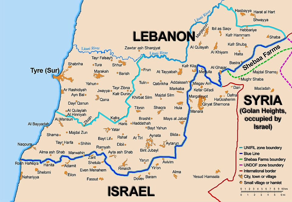
The Israel-Lebanese border is weird, even by the standards of a world full of weird borders. Known as the Blue Line, it heads east from the Mediterranean at Rosh HaNikra, twisting and turning until it reaches Malkia, from where it suddenly heads north to Metula, wrapping itself around the top of the Galilee Panhandle before it reaches the Syrian border. Unlike many borders, it contains no natural boundaries to distinguish between the two countries it divides. The most obvious natural boundary, the Litani River, lies nearly 30km to the north. Why, then, did this not mark the border between Israel and Lebanon?
The border was originally determined between French Syria and British Palestine in the Paulet-Newcombe Agreement of 1923, following the Sykes-Picot Agreement and various other negotiations. Following their conquest of Palestine, the British wanted the Litani to form the northern border, and for it to stretch across to the Banias springs on the slopes of Mount Hermon. As David Eshel writes in his article ‘The Israel-Lebanon Border Enigma’: “It is unfortunate, in view of subsequent events, that this viewpoint with its far-reaching strategic implications was a casualty of lengthy political haggling and was ignored.”
The border was never fully delineated, and at first made little difference to the lives of those living on either side, who continued to cross freely. The majority-Shi’ite south of Lebanon remained neglected and more closely integrated with northern Palestine. Eshel writes: “The result was twofold: on the one hand, the traditionally good neighborly relations between Jews, Christians and Shi’ite Muslims remained close, but on the other, the lack of governmental control produced a haven for irresponsible elements, such as smugglers and armed Arab bands infiltrating into Palestine.”
This situation intensified when the Arab Revolt broke out in 1936. South Lebanon now became an area for recruitment and cross-border raids. In 1937 Sir Charles Tegart, previously a member of the Secretary of State’s Indian Council, was sent to Palestine to suppress the revolt; in his first report he noted that the border could not be effectively defended because of the topographical conditions. To improve this situation, a frontier road and concrete blockhouses were built.
During the War of Independence, the Lebanese army attacked and captured two small Israeli villages along the border; in May 1948 Palmach commandos destroyed a bridge over the Litani, while Ben-Gurion spoke of conquering the area up to the river. In October 1948, during Operation Hiram, Israel took control of the border region and subsequently remained in southern Lebanon until the armistice agreement in March 1949. During this period, some of the Christian and Shi’ite village heads asked for protection from Israeli forces against Sunni Muslim marauders; this request was rejected. “Years later Israelis were to look back on those missed opportunities with great longing, but by then it was too late, the border had turned into a battlefield,” Eshel writes.
Following the armistice agreement, controversy remained over the Har Dov/Shebaa Farms area, although there were other complex issues, for example the Alawite village of Ghajar. Despite its weirdness, though, the Blue Line has proved surprisingly durable. Israel occupied southern Lebanon following the First Lebanon War; one month after its withdrawal in May 2000, the UN Security Council endorsed UN Secretary-General Kofi Annan’s assertion that Israel had “withdrawn its forces from Lebanon in accordance with Resolution 425.”
For some Israelis, though, the Litani remains the holy grail. Avigdor Lieberman, for example, said that “everything between the Litani and Israel must be under the control of the IDF,” a feeling that has only increased since October 7 Meanwhile, a group called Uri Tzafon (named after a biblical verse that means ‘Awaken, O North’) has demanded Israeli civilian settlements in south Lebanon. Eliyahu Ben Asher, one of the founding members, says: “what is called ‘southern Lebanon’…is really and truly simply the northern Galilee.” While geographically speaking he is correct, the chances of the group realizing their dreams are slim, although as Akiva Eldar notes, “they [the settler movement] planted seeds, which grew into trees, which grew into a jungle.”
What, then, has happened along the Blue Line since I published the original version of this piece eighteen months ago? First, on 27 November 2024, a ceasefire took effect, ending fourteen months of fighting. Built on UN Resolution 1701, it called for Israel to withdraw south of the Blue Line, the Lebanese army to deploy south of the Litani, and Hezbollah to disarm. In practice, though, it was doomed from the start. Hezbollah didn’t back down, Israel kept troops on five hilltop positions inside Lebanon, and fighting continued, although in August 2025 the Lebanese government did commit to a state monopoly on arms and a timetable for Hezbollah’s disarmament, although predictably Hezbollah refused to accept this.
On 2 March 2026, two days after the joint US-Israeli strikes on Iran, Hezbollah fired on Israel in solidarity with Tehran, and Israel responded with a full-scale air and ground campaign known as the 2026 Lebanon War. Israeli forces pushed roughly ten kilometers past the Blue Line, and Lebanese officials reported hundreds killed. A ten-day truce began on 16 April 2026, but occasional fighting continued for months afterwards.
Recently, on 26 June 2026, Israel, Lebanon, and the United States signed a trilateral framework agreement in Washington. According to this agreement, both sides recognized each other’s sovereignty and declared their intent to end the state of war between them. The Blue Line, meanwhile, was given a neighbor in the form a Yellow Line – a security zone stretching around ten kilometers into Lebanese territory that Israel says it will hold until Hezbollah is disarmed. A trilateral Military Coordination Group (MCG4L) was set up to oversee implementation, and two pilot zones were designated for an initial Israeli withdrawal and Lebanese army deployment.
The Lebanese army took over its first pilot village, Zawtar al-Gharbiyrh, in late July 2026, but there are still tensions, and some involved in the talks have compared the arrangement, unfavorably, to the 17 May 1983 agreement between the two countries that linked Israeli withdrawal to a Syrian withdrawal that never happened, leading to the deal’s collapse. And late last month, the IDF blew up a Hezbollah tunnel system beneath the Beaufort Ridge in southern Lebanon after Hezbollah targeted an unmanned bulldozer with an explosive drone.
So it is ironic, then, that an awkwardly assembled colonial border has come to be seen as unmovable, particularly as it has undoubtedly helped Hezbollah continue its war against Israel. If one were to start from scratch, the Blue Line would not have been delineated in the way it has. Whatever the outcome of the embryonic deal between Israel and Lebanon, the smart money is on it remaining in place.
No posts
Comments
Nothing yet. Say the first thing.
Sign in to join the conversation.