
SpaceX SPCX 0.00%↑ has emerged as a high-profile supporter of NextNav’s NN 0.00%↑ proposal to reorganize the lower 900 MHz band for terrestrial 5G-based positioning, navigation and timing services, a move analysts say strengthens the company’s case at the Federal Communications Commission.
In an August filing, SpaceX urged the FCC to impose faster, technology-neutral buildout requirements on scarce low- and mid-band spectrum and specifically cited NextNav’s 900 MHz plan as an opportunity. Analysts noted the endorsement carries weight. “It is no small matter that SpaceX has implicitly endorsed the FCC action that NextNav is requesting,” MKI Global Partners said, adding that the support “should contribute to continued momentum for the Notice of Proposed Rulemaking.” B. Riley Securities called the backing significant given SpaceX’s resources and political influence, suggesting the company could become a leading candidate to put the spectrum to use.

NextNav wants to enable a ground-based 5G network that would complement and back up GPS while supporting broadband uses. The company argues the reorganized band could deliver national security, public safety and economic benefits at no cost to taxpayers. SpaceX’s interest appears tied to its own terrestrial and direct-to-device ambitions, which would benefit from low-band spectrum’s strong propagation characteristics.
The proposal continues to face strong opposition from existing users of the lower 900 MHz band. RFID equipment makers, security and alarm system providers, utilities and other Part 15 device operators have argued that higher-power 5G operations could cause harmful interference and force costly equipment changes. NextNav has submitted technical studies and conducted real-world demonstrations claiming coexistence is feasible, but critics maintain the testing is inadequate and the risks remain significant.
The FCC has advanced a draft Notice of Proposed Rulemaking on PNT technologies into interagency review, including examination by the White House Office of Information and Regulatory Affairs. Timing for any formal NPRM or eventual Report and Order remains uncertain. Some analysts view this fall as a possible window for progress on the NPRM, though a final decision is expected to take considerably longer and is not guaranteed.

We’ve updated our media kit and low-cost advertising rates. Please contact us at info@driverlessreport.com for more information…or go to our updated Advertising Page.
Wireless giant AT&T T 0.00%↑ alongside rival carriers T-Mobile TMUS 0.00%↑ and Verizon VZ 0.00%↑, is seeking to overturn and claw back tens of millions of dollars in fines imposed by the Federal Communications Commission over location privacy violations. The telecom operators argue that the administrative forfeiture orders issued by the regulatory agency are nonbinding following recent Supreme Court precedents restricting federal agency authority. The legal filings represent a coordinated effort by the telecommunications industry to challenge federal administrative enforcement mechanisms and avoid substantial financial penalties.

The dispute stems from a long-running federal investigation into how mobile carriers handled sensitive customer location data. In 2020, the FCC proposed more than $200 million in combined penalties against AT&T, T-Mobile, Sprint, and Verizon after discovering the companies sold customer real-time location data to third-party data aggregators without obtaining clear consent. Regulators found that the aggregators subsequently resold access to bounty hunters, bail bondsmen, and unauthorized location-tracking services, exposing millions of mobile subscribers to severe privacy and safety risks.
AT&T and its industry peers contend that the administrative process used by the commission to levy the penalties violates constitutional separation-of-powers principles. Citing recent landmark decisions by the U.S. Supreme Court that limit the judicial power of federal regulatory agencies, the carriers argue that the FCC lacks the statutory authority to issue binding monetary forfeitures without providing a jury trial in a federal district court. Consequently, the operators maintain that any payments remitted under the orders should be refunded or formally vacated.
Privacy advocates and consumer protection organizations have sharply criticized the carriers’ attempts to escape financial liability, warning that dismantling regulatory enforcement mechanisms undermines consumer safety. Critics argue that allowing major telecom providers to retroactively evade penalties sets a dangerous precedent for corporate accountability, particularly regarding the handling of sensitive personal data. They emphasize that the location data shared by the carriers compromised individual physical safety and violated fundamental consumer trust.

Expert nationwide installation services for fleet technologies.
Google GOOG 0.00%↑ is expanding the capabilities of its navigational ecosystem by integrating direct food ordering functionality into Ask Maps, its conversational artificial intelligence assistant. The update allows users to search for local dining options, browse menus, and complete restaurant orders directly within the mapping application using natural language prompts. By combining geographic location data, merchant inventory systems, and payment processing, the feature aims to transform the navigation platform from a discovery tool into an end-to-end transactional hub for daily consumer activities.
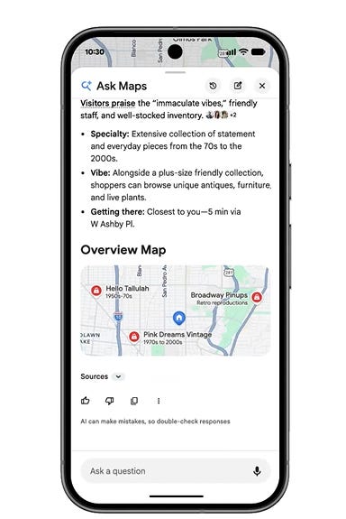
The conversational food ordering feature builds on a broader series of updates rolled out to Google Maps throughout 2026 aimed at embedding artificial intelligence across everyday navigational workflows. Earlier this year, the platform introduced advanced lane-level guidance powered by computer vision, enhanced 3D Immersive View coverage for major transit hubs, and real-time charging site diagnostics for electric vehicle drivers. Furthermore, Google expanded its generative AI discovery tools globally, enabling users to query complex localized prompts such as finding specific ambient dining settings or niche retail items within a defined radius.
The integration simplifies the multi-step process traditionally required to order food online, removing the need to toggle between separate food delivery applications and web browsers. Users can initiate requests using voice commands or text, specifying dietary preferences, price points, and preferred pickup or delivery windows. “By bringing conversational food ordering directly into Ask Maps, we are eliminating friction between local business discovery and action,” said Miriam Daniel, vice president and general manager of Google Maps. “Our goal is to make visual and conversational exploration seamlessly actionable, allowing users to go from asking a question to completing a transaction in seconds.”
To fulfill orders, Google has partnered with a network of national food delivery platforms and point-of-sale aggregators, ensuring broad merchant coverage across urban and suburban markets. The system leverages existing Google Pay infrastructure to handle checkout securely, matching user preferences with participating local restaurants. Merchants featured on the platform retain control over their menu listings and pricing while gaining direct access to consumers seeking immediate dining solutions within the mapping interface.
The feature is rolling out initially to Android and iOS users in select metropolitan areas across North America before expanding globally later this year. Google plans to continue expanding the transactional capabilities of Ask Maps, with future updates scheduled to introduce venue ticketing, service appointments, and hotel reservations directly within the conversational interface.

Are you ready for your next Trade Show? JB Media is your one-stop shop for printing, promotional products and corporate wearables. Let us help you prepare for your next show! Visit our website, e-mail us at Service@JimBrownMedia.com or call us direct at (720) 588-0493.
The American Geographical Society has selected Charlie Trimble, founder of Trimble Inc. TRMB 0.00%↑, to receive its O.M. Miller Cartographic Medal for his pioneering role in transforming GPS into a commercial technology that reshaped mapping and geospatial industries.
The medal, one of the society’s highest honors, recognizes individuals whose work has significantly advanced cartography and the geographic sciences. Trimble will receive the award on Sept. 15, 2026, during the society’s Globe Signing Ceremony at the Explorers Club in New York City.
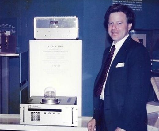
“Charlie Trimble helped transform GPS from an emerging technology into one of the defining innovations in modern geography,” said Lee Schwartz, CEO of the American Geographical Society. “His early vision for the commercial potential of precise positioning laid the foundation for modern mapping, navigation and countless industries that rely on geographic intelligence.”
Trimble said the recognition was deeply meaningful. “Growing up, Sputnik sparked my fascination with science and engineering, and years later, GPS represented one of those rare technologies with the potential to fundamentally change the way people worked,” he said. “Bringing that vision to life took an extraordinary team, and it’s been incredibly rewarding to see the impact GPS has had across so many industries.”
In the late 1970s, when GPS remained an experimental military system, Trimble recognized its commercial potential. He founded the company in 1978 and, six years later, introduced the world’s first commercially viable GPS receiver. Under his leadership, Trimble went on to pioneer Real-Time Kinematic positioning, which delivered centimeter-level accuracy and expanded GPS use across surveying, construction, agriculture and transportation.
"Charlie had the courage to invest in GPS long before the world understood its potential," said Rob Painter, president and CEO of Trimble. "He saw an opportunity where others saw uncertainty and helped turn an experimental satellite system into technology that transformed industries. That willingness to take risks, innovate and think decades ahead continues to define Trimble today."
News tip? Send them to kdennehy@driverlessreport.com. Go to www.locationbusinessnews.com for more news. Location Business News is looking for your company’s news, products and use cases to feature in each issue.
PlanetiQ Completes Major Milestone for Next-Generation of GNOMES Satellites. “PlanetiQ has completed manufacturing and environmental testing for its next-generation GNOMES satellites. Equipped with the company's proprietary Pyxis sensors, the new spacecraft will expand PlanetiQ's on-orbit constellation to capture higher volumes of global radio occultation data across multiple satellite navigation networks.”
U.S. Space Force and Japan Successfully Launch U.S. Sovereign Space Domain Awareness Payload. “A U.S. Space Domain Awareness payload hosted on Japan's Quasi-Zenith Satellite 7 (QZS-7) successfully launched on a Japanese H-3 launch vehicle from Tanegashima Space Center in Japan on August 10, 2026. This is the final of the two launches that are part of the Quasi-Zenith Satellite System-Hosted Payload (QZSS-HP) program, the first bilateral U.S. Japan cooperative space effort focused on national security.”
EUSPA’s First GNSS and Secure SATCOM User Technology Report. “As new GNSS frequencies and signals become available for civilian applications, receivers’ manufacturers are keeping up to speed by upgrading their receivers’ baselines, thus addressing most of the 110 GNSS satellites in Medium Earth Orbit. This advancement in receivers’ technology is well supported by the international coordination among GNSS, RNSS, and SBAS providers that has led to the adoption of open access signals with compatible frequency plans, common multiple access schemes, and modulation schemes.”
Ericsson, MediaTek Demo Sub-30cm Positioning Over Commercial 5G Network. “Ericsson ERIC 0.00%↑ and MediaTek have successfully completed a world-first end-to-end (e2e) test of high-precision outdoor positioning. Using standardized 3GPP technology for GNSS RTK, the partners demonstrated positioning accuracy down to a ten-of-centimeters directly over a commercial 5G network.”
Saab and Royal Navy Test Giraffe 1X Radar Network Without GPS Timing.
CHC Navigation Publishes 2025 ESG Report, Reinforcing Its Commitment to Sustainable Development.
Skyband Develops LEO-Powered PNT Unit to Validate GPS on Aircraft.
SuperCom Wins Third Electric Monitoring Contract in Texas, Displacing Incumbant. “SuperCom's PureOne is an all-in-one GPS tracking bracelet designed for continuous indoor and outdoor location monitoring.”

Spire Global Awarded $3.7 Million NOAA Contract for Satellite Weather Data.
Independent Irish RTK Network Brings Nationwide Precision Positioning.
Neros Raises $250 Million Equity Round at $2.5 Billion Valuation.
The FCC Moves to Retroactively Ban Drones With Lidar Obstacle Avoidance. “Many photographers and videographers will be surprised to learn that the FCC considers camera drones with lidar obstacle avoidance, like the consumer-grade Air 3S, Avata 360, and Mini 5 Pro, to be weapons of war.”
AI Drone Firm Launches Dedicated U.S. Federal Team for GPS-Denied Navigation.
Cedar Electronics Selects TomTom Orbis Maps to Enhance Speed Awareness Across the United States. “TomTom [TOM2] has announced that Cedar Electronics has selected TomTom Orbis Maps for integration into its Escort and Cobra radar detector products in markets where these features are supported.
By leveraging TomTom’s speed limit data, Cedar Electronics can validate and maintain up-to-date posted road speed information across the United States.”HERE Technologies achieves AWS AI Competency. “HERE Technologies has announced that it has achieved the Amazon Web Services (AWS) AI Competency in the AI Software category. This specialization recognizes HERE as an AWS Partner that helps customers and the AWS Partner Network advance services, tools and infrastructure pivotal for implementing AI technologies, including generative and autonomous AI systems.”
Researcher Tricks Apple’s Find My Into Sharing Location Data with Linux. “However, the 22-year-old researcher, who goes by ‘Zerotistic,’ devised a way to enroll a Linux-based machine into the iNetwork, tricking Apple AAPL 0.00%↑ into sending the people-location data it exclusively reserves for [their] devices.”
360maps Now Supports AR Navigation Connecting Indoor and Outdoor Spaces.
NEW Low-Cost Advertising Rates For 2026! Advertising starts at only $150 per issue. Please contact us at info@driverlessreport.com for more information…or go to our updated Advertising Page.
Japanese Self-Driving Startup Plans U.S. Office, Targets $10 Billion IPO Valuation (Wall St. Journal subscription). “Japanese autonomous-driving startup Turing is looking to enter the U.S. market, with a potential listing there within the next five years that would value the company at about $10 billion, its top executive said.”

Japanese AV company Turing is heading to the United States (Turing). Uber Partners With China’s Pony.ai for 2,000 Robotaxis in Europe.
Tesla Wins Nevada Robotaxi Permit But Fleet Is Capped at 10 Vehicles. “The Nevada Transportation Authority approved Tesla TSLA 0.00%↑ for a maximum initial fleet of 10 fully autonomous vehicles. Tesla had applied to operate as many as 5,000 vehicles across Clark County during its first year.”
NHTSA Takes Major Steps in Establishing an Autonomous Vehicle Framework.
Uber, Waymo Go From Robotaxi Partners to Competitors and Waymo Gets The Green Light Across California.
Self-Driving Trucks Are Already Hitting The Road In California.

Element Submits Proposal to Acquire FleetPartners Group. “FleetPartners shareholders would receive cash consideration of $3.80 per share, representing a total equity value of approximately $578M million.”
Walmart to Deploy 90 million Wiliot IoT Tags By End of 2026.
Geotab Launches Unified Investigations Solution to Reduce Fleet Liability Costs.
Samsara’s Tiny Tracker Offers 45-Day Visibility for Any Shipment and Samsara Asset Tag and Asset Tag XS provide GPS asset tracking for fleets.
Linxup Partners with LEEO to Enable Fleets to Meet Telematics Standards. “New integration connects fleet operators to required GPS tracking, dash cam equipment as part of LEEO insurance purchase process.”
Motive Launches AI-powered System to Track and Manage Maintenance Workflows.
Trimble Announces Second Quarter Results and Raises Full Year Guidance. “Trimble TRMB 0.00%↑ reported total revenue of $972 million for the second quarter, marking an 11 percent increase year-over-year. Annualized recurring revenue reached a record $2.51 billion, driven by strong growth across its core operating segments. Despite operational gains, the company recorded a GAAP net loss of $471.7 million due to a non-cash $562 million goodwill impairment in its Transportation and Logistics unit. Following the strong underlying performance and non-GAAP earnings beat, Trimble raised its full-year revenue outlook to between $3.90 billion and $3.95 billion.”
Gravis Robotics raises $200M from SoftBank to Retrofit Excavators. “Its Gravis Rack, which packages an AI chip, cameras, a lidar sensor and rear vehicle masts carrying GPS/GNSS RTS gear, clips onto machines from Caterpillar CAT 0.00%↑, John Deere DE 0.00%↑, JCB and Hitachi and turns them into autonomous units.”
NextNav Reports Second Quarter 2026 Results and Operational Highlights.
Munich-Based NavVis Raises €74.5 Million to Build its Spatial Data Engine and Accelerate AI Roadmap.
Ituran: Strong Q2 Results Reveal The Data Opportunity Hidden Inside Its Telematics Network.

The D-Day Visitor’s Handbook: Your Guide to the Normandy Battlefields and WWII Paris by Kevin Dennehy and Steve Powers. The guidebook uses location technology from what3words to locate monuments, museums and other attractions. Get your guidebook today.
Send your news releases to kdennehy@driverlessreport.com. Go to www.locationbusinessnews.com for more news and an archive of stories.
Trimble TRMB 0.00%↑ has expanded its CenterPoint RTX Fast network correction service across Brazil, Paraguay and Uruguay, delivering near-instant, sub-centimeter GNSS positioning via L-band satellite and IP delivery. The expansion allows operators in agriculture, surveying, civil construction and automotive industries to achieve continuous, high-precision positioning without relying on costly physical base stations, the company said. Powered by a continuously operating reference station network monitored 24/7, the service slashes signal convergence times to as low as one minute across challenging Latin American terrain. The cloud-delivered solution eliminates physical hardware risks like theft, vandalism and weather damage while supporting autonomous field robotics and precision farming.
Contact: Trimble, https://positioningservices.trimble.com/en.
JAVAD GNSS has introduced a new family of tightly integrated GNSS and inertial navigation system (INS) products designed to maintain accurate positioning in contested environments. The new product line pairs the company’s multi-constellation GNSS receivers with commercial and defense-grade inertial measurement units (IMUs) using a custom interface board that manages electrical connections, time synchronization, and data paths.
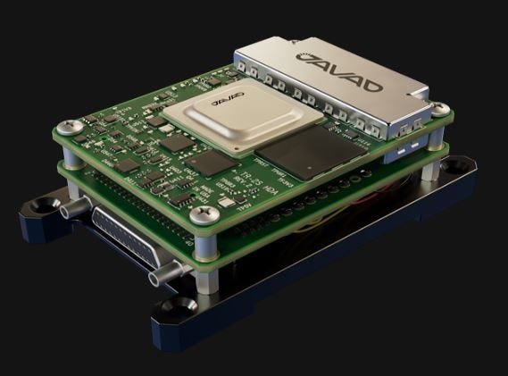
By delivering continuous position, velocity, and orientation data when satellite signals are jammed, spoofed, or denied, the turnkey systems target demanding applications across aerospace, defense, autonomous vehicles, and robotics. The pre-assembled hardware stack offers integrators a flexible, configurable layout that can be deployed as-is or reconfigured to meet specific platform space constraints, the company said.
Contact: JAVAD GNSS, sales@javad.com, www.javad.com.
HERE Technologies has partnered with Octave Intelligence OCTV 0.00%↑ to deliver advanced location intelligence capabilities into Octave OnCall Dispatch, Octave’s computer-aided dispatch solution for incident response operations. The partnership combines Octave’s dispatch and incident management expertise with HERE’s mapping data and location services to help providers respond to incidents faster, operate more efficiently and deliver improved safety outcomes for road users, the company said.

In other company news, HERE and New South Wales Rural Fire Service, the world’s largest volunteer fire service with more than 68,000 volunteers, are demonstrating how advanced location intelligence can help emergency responders navigate more effectively across some of Australia's most challenging and remote landscapes.
Contact: Vanessa Lee, HERE Technologies, vanessa.lee@here.com.
All OEM7 receivers come with access to the NovAtel Application Suite as part of managing hardware. Graph is the latest addition to the suite, and empowers users to analyse NovAtel receiver data through interactive plots and mission trajectories, the company said.
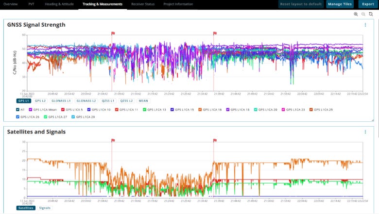
Graph includes a Project Wizard with integrated file validation, and a Position Overview to see mission data in context on a geographic map. Users can visualise and compare across time-series plots, including position, velocity, time, heading and attitude, tracking and measurements, and receiver status, the company said.
Contact: Hexagon|Novatel, communications@novatel.com.
Infinite Electronics has launched a new lineup of Pasternack multi-constellation GNSS antennas featuring advanced anti-jamming technology to support unmanned aerial vehicles in congested environments. Engineered to MIL-STD-810 standards, the ruggedized antennas improve positioning, navigation, and timing performance across multiple global navigation systems and frequency bands.
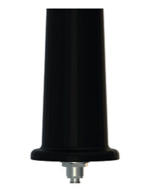
The hardware features specialized interference mitigation designed to suppress low-elevation jamming sources and reject adjacent-band signal interference, the company said. Infinite Electronics will officially showcase the new antenna series alongside its broader portfolio of RF and microwave components at the Commercial UAV Expo in Las Vegas.
Contact: Infinite Electronics, www.infiniteelectronics.com.

Create a FREE ManyMe Account.
CSafe has launched the CSafe Connect Mobile App, bringing its cloud-based shipment tracking and management capabilities to iOS and Android devices. Designed for pharmaceutical manufacturers, freight forwarders, and airlines, the mobile application allows operational teams to monitor container conditions and real-time GPS locations directly from warehouse floors, tarmacs, and transit hubs.
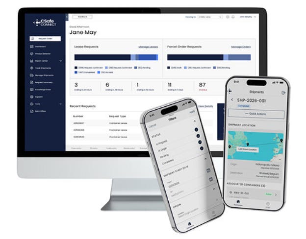
Users can place and manage lease orders, access shipment data on demand, and receive instant alerts to quickly address potential temperature or location issues in transit. By extending desktop functionality to mobile devices, the tool aims to safeguard sensitive pharmaceutical payloads and reduce the risk of product loss across global supply chains, the company said.
Contact: CSafe Marketing, marketing@csafeglobal.com.
Diesel Laptops and Trucker Path have launched a joint promotional bundle aimed at reducing operational costs and downtime for truck drivers and small fleet operators. The limited-time offer provides a $100 discount on the Diesel Decoder diagnostic hardware, which connects via Bluetooth to a smartphone to read manufacturer-specific fault codes and perform maintenance commands in under a minute.

The package also includes 30 days of complimentary access to Diesel Repair Professional, providing mobile access to technical repair documents and wiring diagrams. Additionally, users receive a 30-day subscription to Trucker Path Diamond, offering AI-enhanced trip planning, truck-specific GPS routing, and real-time parking availability across North America.
Contact: Trucker Path, www.truckerpath.com.
L3Harris Technologies named Sam Mehta president, CEO, and board member; Lewis Hay III, independent board chair; and Christopher Kubasik stepped down as CEO, chair, and board member after alleged code-of-conduct concerns.;
The GPS Innovation Alliance endorses the confirmations of Gen. Douglas Schiess as U.S. Space Force Chief of Space Operations; Adam Cassady on his confirmation as U.S. Ambassador-At-Large for Cyberspace and Digital Policy; and Danielle Thumann Severs on her nomination to serve as a FCC commissioner.
KORE Appoints Roi Ross as Chief Growth Officer to Lead Its Global Growth Strategy.
Teletrac Navman names Pankaj Sharma vice president of product management.
Clay Tucker has been named business development manager at Geotab.
Teletrac Navman Appoints New Vice President of Product Management.
David McIntosh has been named strategic telecom manager – APAC at Geotab.
Chief Operating Officer. Advanced Navigation.
Associate Vice President, EMEA Sales (Remote). Geotab.
Director Sales. Honeywell Aerospace.
Senior Electrical Engineer (HW Design). ANELLO Photonics.
Systems Engineering Director, Resilient Navigation. RTX.
Senior Customer Success Manager. Mappedin.
Director, Enterprise Architecture. HERE Technologies.
Director Applied Science ADAS. TomTom.
Director, Sales and Business Development, Autonomous Platforms and New Mobility. Swift Navigation.
Senior Business Development Consultant. Swift Navigation.
Senior Manager Business Development New Markets. Swift Navigation.
Senior Product Manager, Mobile Ecosystem. Swift Navigation.
Senior Product Marketing Manager, Mobile Ecosystem. Swift Navigation.

Click HERE to Join our growing Location Business News LinkedIn Group!
No posts
Comments
Nothing yet. Say the first thing.
Sign in to join the conversation.