
Today I drove to Punchbowl.
I’d been meaning to go ever since I started writing this piece - Punchbowl is the kind of place that turns up in Sydney food writing as shorthand for something authentic and slightly inaccessible, the Lebanese heartland of the city’s south-west. I went, naturally, for booza: traditional Lebanese ice cream.

It was only after sending my mum this photo (obviously to make her jealous) that I found out this place had a personal history. The owners used to have an ice cream shop directly below where my taita (grandmother) lived in a small coastal town near Tripoli in Lebanon. She would lower a basket from her window with money in it and the owner would send up a tub of booza. It was only later buying pastries in Punchbowl that my grandmother suddenly recognised the owner. And now, by pure coincidence, I had bought my booza from that exact shop.
Walk through Punchbowl, Lakemba, Cabramatta, or Marrickville and the food tells you who arrived and when. Sydney is not unique in that, London also has Brick Lane, Brixton, Southall, Peckham’s Rye Lane. Every city with a significant migrant history has neighbourhoods where you can read the waves of arrival through the shop fronts. The difference isn’t whether these neighbourhoods exist, it’s whether they survive. Brick Lane, once the heartland of Bangladeshi settlement, now hosts a Cereal Killer Café and a Brewdog. The Vietnamese strip on Mare Street in Hackney has been thinning for a decade. In Sydney, the same communities that arrived in the 1970s and 1980s are still commercially present in the same suburbs.
That contrast became this piece: why is London slowly being replaced by chains while in Sydney locals can keep their doors open? I retrieved my scraped dataset of 17,127 London restaurants to find out.
The obvious explanation is that London has worse landlords, or worse food, or worse taste. I’m going to argue something different. London is losing its Brick Lanes precisely because it is the kind of city urbanists say you need: walkable, transit-rich, dense and mixed-use. And Sydney’s independent culture has survived because Sydney is, by almost every metric we use to measure good urbanism, badly designed. The car-dependent strip, the quarter-acre block, the Sunday penalty rate, just about every feature a planner would want to fix is exactly what protected the booza shop in Punchbowl.
I’ll show you the data and what we can do about it.
Let’s start with the obvious question: are chains replacing independents in London because they’re actually better?
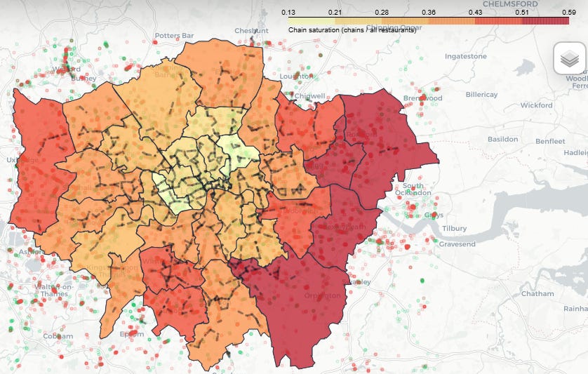
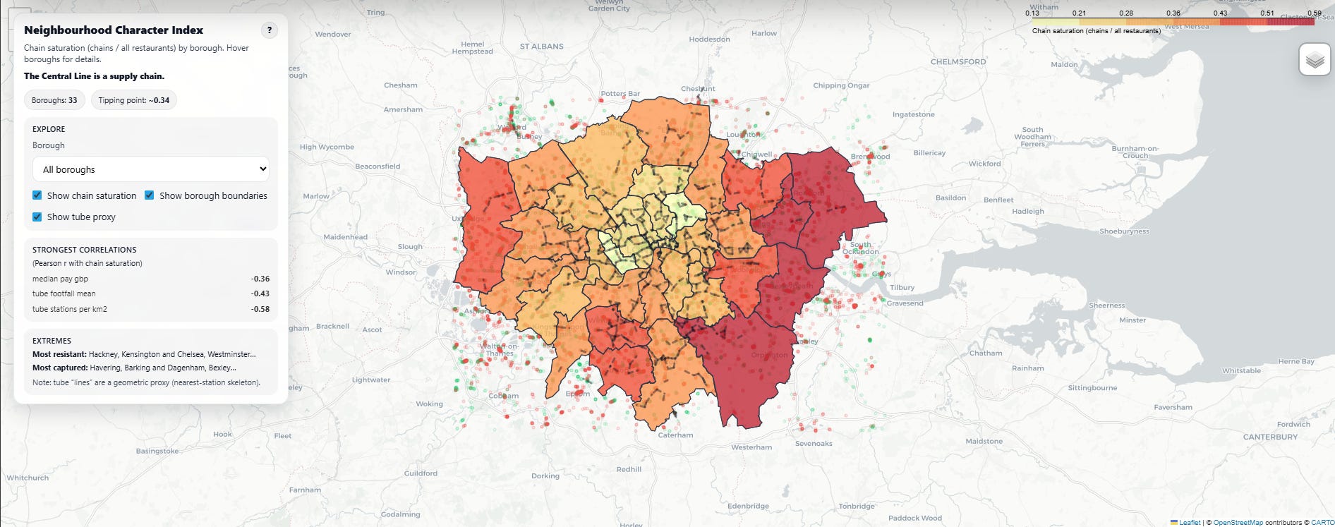
To find out whether a restaurant is a chain or not, I flagged any restaurant brand appearing in 2+ locations across 2+ London boroughs, then manually checked the top 100 to catch false positives. (There are a lot of unrelated pubs called “The [Neighbourhood] Arms.”) This gave me 6,828 chain locations and 10,241 independents. Chains are roughly 40% of London’s restaurant fabric in this dataset, though with stark variation by borough. Hackney, Kensington and Chelsea, and Westminster are the most resistant; Havering, Barking and Dagenham, and Bexley the most captured.
To test survival, I briefly pretended London’s restaurant market was a meritocracy and Google ratings were reliable (this is a huge assumption, as I argued and even tried to correct for in my previous piece on Google Maps, now also out as a Guardian it’s complicated documentary), making survival purely a function of quality. I ranked all rated restaurants from lowest to highest and found where the major chains land. Subway: 10th percentile, McDonald’s: 18th, Greggs: 23rd. Even the “nice” chains such as Wagamama, Nando’s, barely crack the median. If ratings determined survival, these brands would be struggling to stay open. There are over 10,000 restaurants Londoners like better than Pret. Yet Pret has 200+ locations.
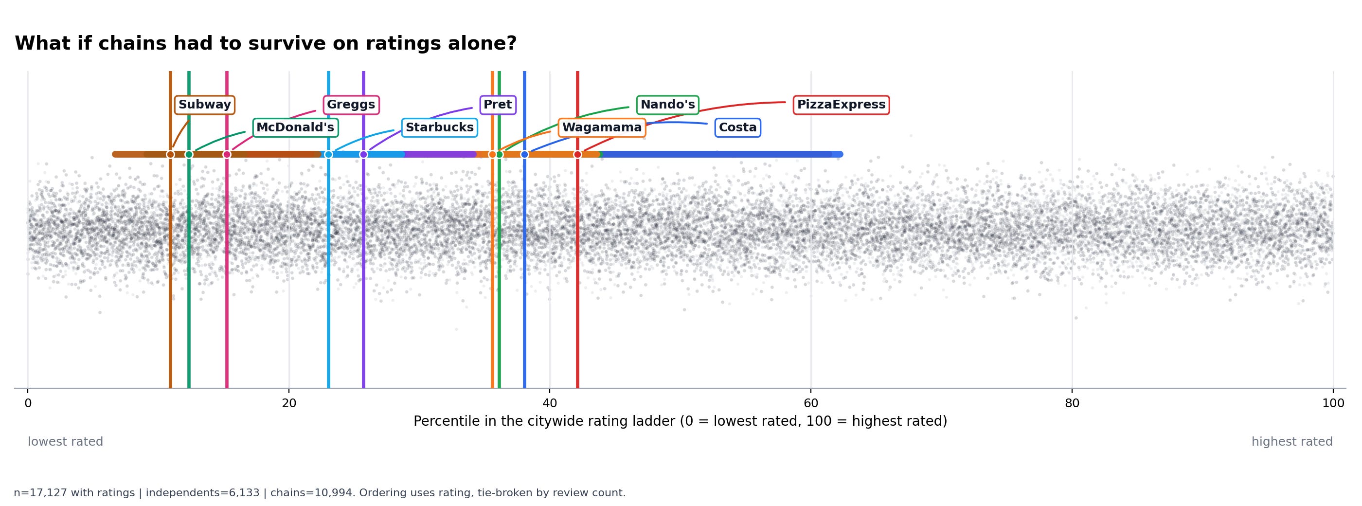
The horizontal bars tell another story: chains don’t just have mediocre averages, they have mediocre ranges. A Starbucks is a Starbucks wherever you go and they’re not selling good coffee, instead they’re selling the certainty that it won’t be bad coffee, at a location you’ll pass whether you meant to or not.
So chains don't dominate because they're better. They dominate because they can afford to be worse, which means the question is what kind of place lets them get away with being worse.
I trained a gradient boosting classifier to predict whether a restaurant is a chain or an independent based on structural features (no names, no menus). Gradient boosting is the default for this job because it handles tabular data and messiness well, and it reveals which features matter most. Some of the features:
Distance to the nearest Tube station (TfL published coordinates)
Foot traffic (station usage stats)
Estimated annual rent (Valuation Office Agency rateable values)
How many other restaurants cluster within 200 metres
Whether it sits on a main road or a side street (OpenStreetMap)
The model predicted correctly 78% of the time. A machine can tell, reliably, whether you’re walking into a Pret or a family-run Thai place just by knowing where it is. The top three features, by a distance: proximity to a Tube station, nearby restaurant density within 200m, and station footfall.
Read those features carefully, because together they describe a very specific kind of place. Not zone 1, where competition is brutal and customers are discerning enough to walk an extra block. Not the far edges of outer London, where the pedestrian volumes simply aren’t there. The chain sweet spot is the in-between band: walkable enough that footfall clears margin, transit-connected enough that customers arrive in pass-through commuter mode, dense enough that a 200m radius generates customers but not so distinctive that being unmemorable becomes a liability. That’s exactly the pattern in the borough map. Hackney and Westminster resist because their customers are choosing; Havering and Bexley get captured because their customers are just passing through.
The unifying claim is this: chains follow legibility. A city becomes legible to a site-selection algorithm when it has been organised into walkable, transit-connected high streets with predictable pedestrian volumes. That legibility is what good urbanism produces and simultaneously what makes a city capturable.
The strongest predictor of chain resistance is the absence of the conditions that make a place computable. Areas with very high station density have fewer chains because the competition is too good. Areas beyond reliable transit have fewer chains because the volumes don’t exist. Everywhere in between is exposed.
See this for yourself by looking at the chain saturation index or “character” index I build for every London borough: the percentage of restaurants that are chains. I’ve also added a few extra rabbit holes for exploration.
Take Blank Street. You’ve seen them: the tiny shopfronts, the mint green branding, the queue of people who needed coffee 30 seconds ago. Blank Street raised ~$120M in VC funding to sell... coffee. The pitch wasn’t “better coffee.” It was: small footprint, high-traffic locations, automated La Marzocco Modbar machines ($20k Italian espresso systems now operated by algorithm), minimal staff. They’re a real estate arbitrage play disguised as a coffee shop. The coffee is the justification for the lease, not the product.
VC money is patient in ways independent capital isn’t, e.g., they can run a location at a loss for two years to build brand density. They can sign a lease that makes no sense this year because they’re betting on the neighbourhood in five. Your local café has to make rent this quarter.
Critically, Blank Street’s model requires a continuous pedestrian corridor. It cannot exist in Houston. It cannot exist in Sydney. It can only exist in a city that planners would describe as functioning well. Walkability is what makes their model possible.
And chains don’t just appear in legible places, someone lets them in. I tried to investigate landlord behaviour directly using the UK Land Registry’s CCOD dataset (every property owned by a company). In practice it was a nightmare: addresses don’t align cleanly, and the big estates own properties through dozens of opaquely-named subsidiaries. I eventually admitted defeat (btw, if any GIS masochists want to take this on, please do.)
What industry reports make clear is how the game works. Commercial landlords aren’t just looking for the highest rent. They want covenant strength: chains can show corporate accounts, family businesses just show faith. Brand fit: yes, landlords use the word “curation” now, I wish I was joking. And tenant improvement: will you spend £500k fitting out the space, effectively giving them a free upgrade when you inevitably close? An independent Vietnamese restaurant with a 4.8 rating fails most of these tests. A VC-backed coffee chain passes all of them. This is why leases have shortened from 15–20 years to 3–5 today. Landlords don’t need your loyalty when the next legible tenant is already calling.
This is the mechanism by which London loses its Brick Lanes. Not in one dramatic moment, but through a hundred individual lease decisions on walkable high streets that capital has learned to read.
In 2000, Starbucks entered Australia with enormous confidence: 84 stores by 2008, then a single retreat that closed 61 of them. The remaining rump survives mostly in airports and tourist traps, propped up by jetlagged Americans who’ve never had a decent flat white (sorry!). This is usually told as a story about Australian taste but it’s actually a story about urban form refusing to become legible.
Post-war migration to Sydney followed the railway lines west. Lebanese families in Punchbowl and Lakemba. Vietnamese communities in Cabramatta. Greeks in Marrickville. Italians in Leichhardt. They settled there not because the suburbs were charming, but because they were affordable: the quarter-acre block pushed property costs outward, and the western train lines made it liveable without a car.
What they then built is the opposite of a walkable high street. These suburbs run on strips: low-density commercial corridors along arterial roads. A car tyre shop, a Lebanese grocer, a Vietnamese bakery, a café with a handwritten sign. The strip is structurally illegible: the pedestrian catchment that makes a Pret viable simply isn’t generated by a road designed for cars. Looking at Sydney, beyond 400 metres from a Westfield, chain presence essentially disappears. The strip belongs to the independents because no algorithm can read it.
Three compounding factors locked this in.
Sydney’s population density is roughly 40% of London’s across a comparable geographic footprint. The pedestrian volumes that activate chain site-selection don’t exist outside the Westfields, which is exactly where the chains cluster and exactly where Australians use chains contentedly, when they want to.
Sunday penalty rates mean a chain’s Sunday shift costs 175% of base rate, compressing the labour arbitrage the chain model depends on. The unit economics that make a Pret work in London don’t work the same way in Sydney even when the location does.
And the duopoly paradox: over 65% of Australia’s grocery market sits with Woolworths and Coles. Australians use chains readily when the category doesn’t reward distinctiveness. Hospitality escaped that consolidation because food quality is discernible, and because the strip gave independent culture room to raise the standard before chains could establish themselves. By the time Starbucks arrived in 2000, the answer to “where would I even put one?” was already “the airport.”
The uncomfortable corollary: if Sydney decided tomorrow to upzone the inner west, build mixed-use development along the strips, and run good public transport down Canterbury Road, the booza shop’s days would be numbered.
This is the awkward bit. The standard urbanist policy menu including denser zoning, more walkability, better transit, mixed-use everywhere, is good for almost everything we care about (climate, congestion, housing, public health) except for the independent commercial culture this piece is about. The answer can’t be “less walkability”. It has to operate on what fills the walkable spaces, not on whether to have them.
So the targets are landlords and capital, not pedestrians.
Regulate the landlords, not just the tenants. San Francisco has “formula retail” restrictions: chains need special planning permission in certain neighbourhoods. It’s imperfect and litigated constantly, but it exists. The UK has nothing equivalent. Our 2020 Use Class E changes went the opposite direction, giving landlords more flexibility to chase the highest bidder.
Make ownership transparent. The Land Registry data I used is free but buried. What if Deliveroo and Google Maps showed “This restaurant is on land owned by Shaftesbury Capital PLC” the way they show hygiene ratings?
Consider commercial rent stabilisation. Yes, I know… rent control is the policy that unites economists in opposition. But commercial rent stabilisation for small retail isn’t the same as residential. It’s been tried in New York for small retail and the sky didn’t fall. At minimum, we could restrict rent increases for existing tenants past certain tenure thresholds.
Protect fragmented ownership. This is the corollary of the whole argument. The neighbourhoods most resistant to chain capture in London tend to have messy, distributed landlord structures and Sydney’s strips have this by accident, Soho and Spitalfields have it by historical fluke. Planning policy could actively discourage portfolio consolidation on designated high streets, treating fragmentation as a public good rather than a market failure to be tidied up.
None of this is simple and it’s highly political. But “the market decides” is also a political choice, one that favours the people who already own the land, and that compounds, gradually and irreversibly, into a city where no one recognises you from your hometown 14,200 kms great circle or by air about 15,500 depending on the flight path and all the current diversions (yes, I actually spent quite some time calculating the distance between Punchbowl and the town in Lebanon).
I’m not per se saying that chains are evil though. I like reliable wifi and a guaranteed seat sometimes and consistency has value and convenience is real. But when a restaurant closes, we tell ourselves stories. Such as: the food wasn’t good enough, they didn’t adapt, the market decided, etc. The market didn’t per se decide though. The market is a landlord choosing between someone who makes great pho and a VC-backed coffee robot and taking the bigger number. The market is a site-selection algorithm that can only see a city once it has been organised into shapes it can read.
My grandmother lowered a basket from a window, and a tub of booza came back up. That is not just a charming family anecdote. It is a tiny model of what cities are for: proximity, trust, memory, repetition, recognition. A city goes beyond just being a housing market or a transport network. It is also the chance that, 14,200 km from where a story began, someone still recognises the taste of home.
The problem is that we keep building cities where the easiest thing to finance, lease, scale, and insure is also the least likely to remember us.
If you found this interesting, the same structural logic applies to pub closures, supermarket deserts, and the political economy of the high street. Subscribe so you don’t miss the next rabbit hole. And if you’d like to keep this Substack alive, buy me a coffee and subscribe:)
No posts
Comments
Nothing yet. Say the first thing.
Sign in to join the conversation.