

0:00
-7:52
After the birth of my daughter, one of the clinic’s advisors2 gifted me (Anastasia) Undrowned: Black Feminist Lessons from Marine Mammals by Alexis Pauline Gumbs. I learned the story of the Omacha, or the Amazonian Boto dolphin. I was struck that these dolphins die in captivity from sleep deprivation. As someone who oscillates in my own bouts of insomnia, I felt tender in learning why these poor beings could not sleep. They need to be held by the river banks so they can rest and breath at the same time. They understand the importance of boundaries as support systems for safety and transition. Their story among other others3 made clear that an examination of boundaries as something real but also imagined was needed to contextualize the clinic’s work around relationship to ourselves, each other and place.
Legal boundaries do not grant rights in land, but they identify the limits of any rights created and claimed. In other words, boundary work (in the legal sense) literally creates the physical map outlining our relationship to each other and our ecologies. This is the legal fiction that overlays property law. Without property boundaries, we cannot ascertain property rights.
The origins of the conventional system of boundary making in the United States comes from English tradition of beating of the bounds. Usually at the behest of the church, a community would walk (or in some rural parts of the British Isles still walk) town perimeters and collectively agree on the boundary lines. To mark the shared agreement of a boundary, a local child would sometimes be hung upside down and hit on the head with a large rock, encouraged to explore a stinging nettle bramble or pushed into a frigid stream.4 In the event there was a future dispute on the boundary line, the local child would be called to testify and record their memory of place based on that moment of violence.5 Pain association it seems was a considered a reliable memory aid.
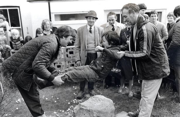
Though children no longer play such an active role in boundary making, there are two main forms of modern land surveying that evolved from the beating of bounds: (1) the metes and bounds method and (2) the rectangular method.
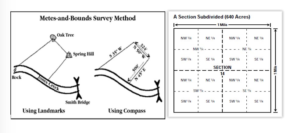
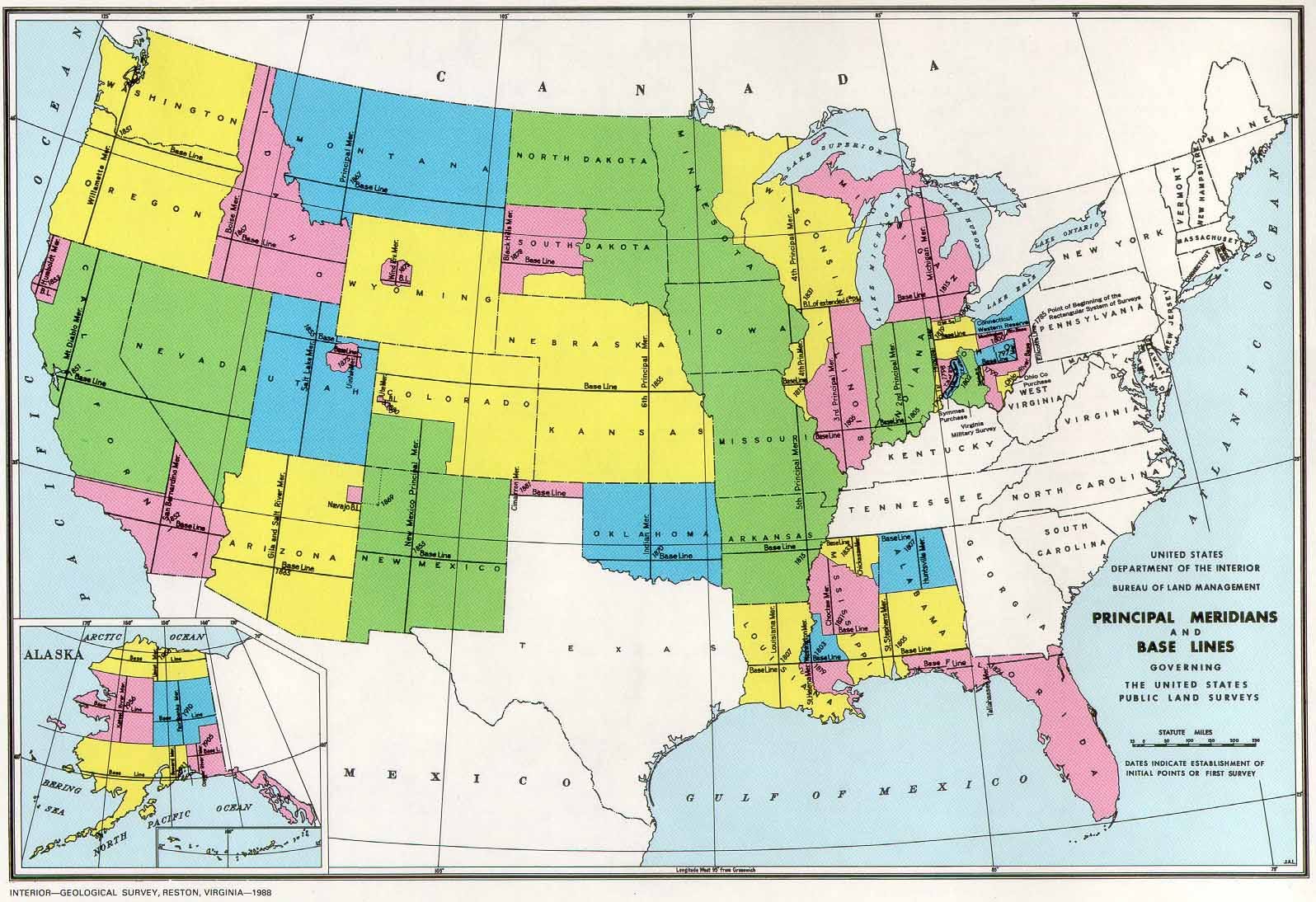
A metes and bounds description starts from a point of beginning and traces the outline of the property's boundary lines until the line is closed. The result is that the land boundaries can take all sorts of shapes. This is because the surveyor measures in distances, angles, and landmarks. This variety of surveying occurs most often in “state-land states.”6 Before the original 13 colonies became territories under the federal government, the land was surveyed, controlled and distributed by the then-governing entities, such as the colonial governments.
In contrast, the rectangular surveying method divides lands into square townships of thirty-six identically-numbered sections of 640 acres or one square mile each. These lines are based on principal meridians (North to South coordinates) and base lines (East to West coordinates). This rectangular system was created by federal legislation used in “public domain states” to homogenize our boundary making process.7
In present times, surveying is done by state-licensed land surveyors. These people are generally employed either by the government and private individuals. Their work generally falls into drawing original surveys or retracing old boundary lines. Maybe somewhat obviously, the object of an original survey is to create boundary lines. Whereas, the object of a retracement is to find the evidence (“footsteps”) of the original surveyor and then to redescribe the footsteps by today’s standards.
Once the surveyor creates the original boundary lines, those invisible borders exist forever, at least until modified by law. The term of art for this is unassailable or free of error. As a result, most of the work of modern land surveyors is that of retracement.8
Notably, attorneys and judges have little to no say in boundary making unless there is a dispute between the parties affected by the line. To those of us that are not land surveyors or engineers, modern boundary making in the United States really seems to have been reduced to a mathematical equation. If you look at the legal description on a document from any land-based transaction, it really does look like a problem set from 9th grade geometry:
This formulaic approach of property descriptions and legal boundaries creates rigid governance structures, missing the spatiality and dynamic relationality all life forms have to land.
Many know in their bodies that the earth honors boundaries of constant transition in remarkable ways. I’ve had the word ecotone stuck in my head for a little over a year now. The word describes the place of convergence between two distinct ecological communities like a wetland or grassland.9
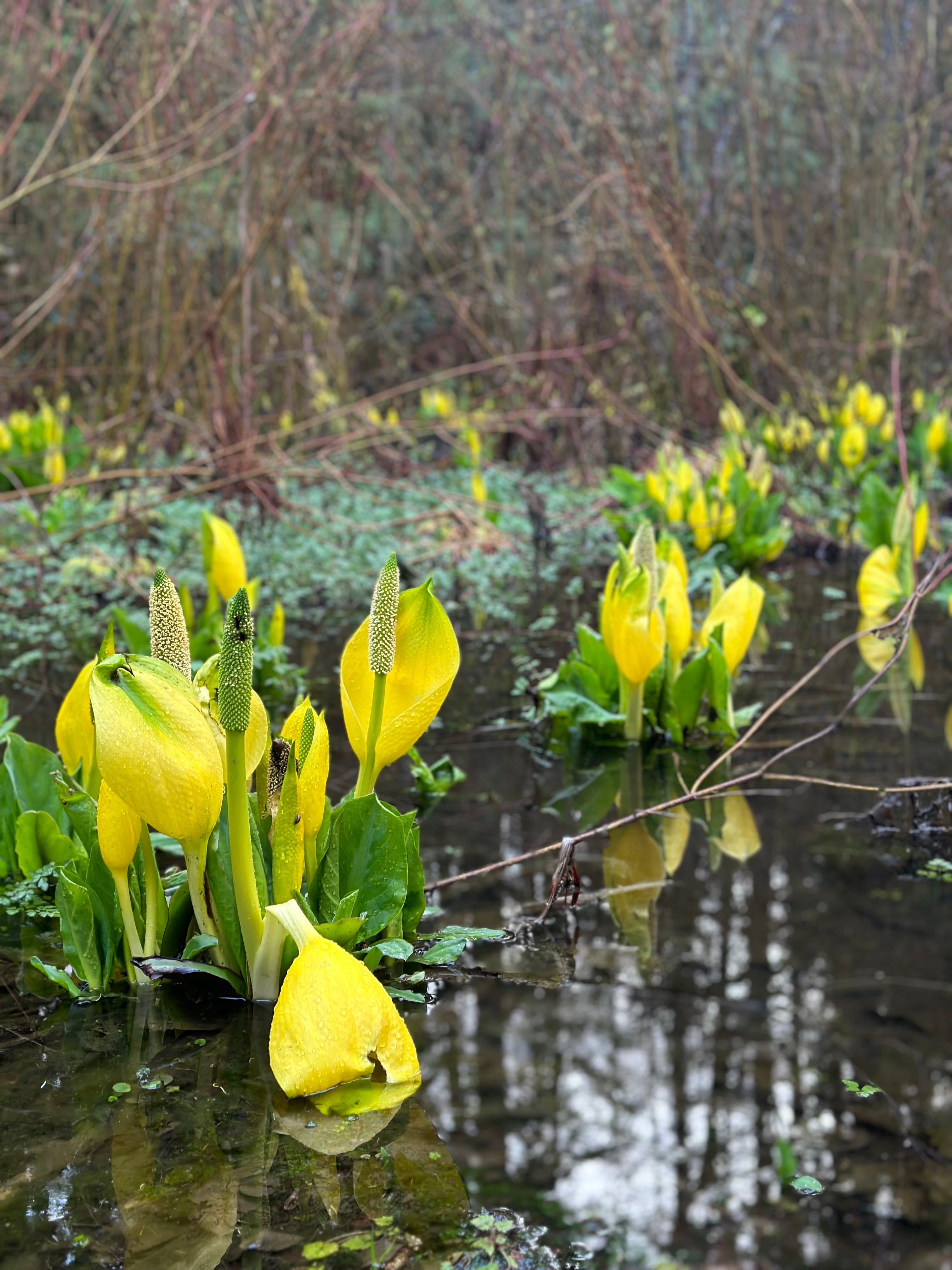
What makes ecotones so special is that they tend to generate diversity via, but not limited to, the hybridization of new species and hold the literal space for transition. Though there are exceptions, the inherent diversity provides benefits to that community since the “populations in ecotones are potentially pre-adapted to changing environments, they may be more resistant to climate change [and] biotic invasions... "10
Perhaps I’m naive (and maybe being a bit reductive myself?) but I gravitate towards these small ecological niches to guide the clinic’s work around boundaries. This human way of boundary making through surveying and then subsequent written legal documentation is inherently flawed as it assumes we can actually “own” anything. Everything at every moment is in transition: birthing, living, dying or something in between. Artificial quadrants and unseen walls do not protect humans from this fact. Nonetheless, I’m still stuck on what this translates to in modern times: How can we capture that intangible quality of knowing a place so intimately it feels like an extension of ourselves? What does it mean to be a neighbor to human and more-than-human kin? How can the overculture adapt beyond modes of objectifying and commodifying land and specie? Is it possible to be safe with each other?
Like most of the questions we ask ourselves, there are no answers, only more wonder-filled questions and daydreams. The prayer being that each question brings us a trace closer “to finding our collective heartbeat.”11
Omacha is the word for the boto dolphin in Tikuna. They are also known as muje o muñé in Piaroa; muña o muñap in Puinave; panábë in Guahibo; jamana o pirarihuara in Yucuna; jíamana in Huitoto; wi?wi in Siona; panabü in Sikuani. For more information, visit: https://omacha.org/delfines-de-rio/.
Forever thank you to you, Jen Calkins!
Other treasures include the lifecycle of moss, conversations with mentoring friends, the naturally hybridized peonies of the Mediterranean and my daily practice of visiting swamplands.
Wilks, J., Customs Uncovered: Beating of the Bounds. Tradfolk. https://tradfolk.co/customs/beating-the-bounds/ (last visited April 19, 2023).
Brown, Curtis M. 1908-, Walter G. 1930- Robillard, and Donald A. Wilson. Brown's Boundary Control and Legal Principles 7th ed., Wiley, 2013.
Connecticut, Delaware, Georgia, Kentucky, Maine, Maryland, Massachusetts, New Jersey, New York, North Carolina, Pennsylvania, Rhode Island, South Carolina, Tennessee, Texas, Vermont, Virginia, and West Virginia.
Alabama, Alaska, Arizona, Arkansas, California, Colorado, Florida, Idaho, Illinois, Indiana, Iowa, Kansas, Louisiana, Michigan, Minnesota, Mississippi, Missouri, Montana, Nebraska, Nevada, New Mexico, North Dakota, Ohio, Oklahoma, Oregon, South Dakota, Utah, Washington, Wisconsin, and Wyoming.
Some basic surveying language used to create or retrace boundaries:
A line invisibly divides land into separate “parcels” explained only by its relationship to other visible markers like a wall, a ditch, a crooked fence, or a hedge.
A corner is at the end of a boundary line or at a change in direction. To define a line, there must be two corners one at each end of the line. The corners must be created by the survey and noted in legal documents (like a deed).
A monument is a physical manifestation set at or near a corner. A corner does not have to be monumented. Monuments may be classified as either natural and artificial.
Surveyors make a distinction between a boundary line and a property line. Boundary lines between lands are created in several ways, yet until written documents (e.g., deeds) or legal statutes or principles attach, property lines are nonexistent. However in many instances, the boundary and the property line are the same thing.
Kark, S., Effects of Ecotones on Biodiversity, Science Direct. https://www.sciencedirect.com/topics/agricultural-and-biological-sciences/ecotones (last visited April 19, 2023).
Kark, S., Effects of Ecotones on Biodiversity, Science Direct. https://www.sciencedirect.com/topics/agricultural-and-biological-sciences/ecotones (last visited April 19, 2023).
This is phrase that Meadow Vindel-Carder so eloquently said in our last advisory gathering. Haunting me ever since.
No posts
Comments
Nothing yet. Say the first thing.
Sign in to join the conversation.