
Welcome or welcome back to History Buzz! We’re back after a hiatus and looking forward to sharing new stories with you in 2026.
If you’re a subscriber to the Buzz, thank you! If you’re new here, or you haven’t become a subscriber yet, hit that subscribe button to have History Buzz delivered directly to your inbox. If you can, please consider a paid subscription to support the research and writing that make History Buzz possible.
Are you a bike rider? Do you have a favorite local ride?
Recently I came across this article in the Andover Townsman written about a bike ride taken on July 21, 1899. The unknown author was a reporter for the Andover Townsman and had written a series of articles for the Andover Townsman describing bicycle excursions around Andover. The author titled the series - Some Things That May Be Seen On An Andover Bicycle Trip.
The article is reprinted here with the description of what the author saw during his ride on July 21, 1899, and my observations and history of some of the places as they exist now are printed in bold and italic print.
The ride was made on a chainless bike that was on loan from H.F. Chase. The author on this ride was accompanied by a friend with a camera.
We started our ride from the Square at 8:30 on a most perfect day when all of nature seemed to smile wheeling down Essex Street, where the steepness of the hill and the location of the Boston and Maine railroad crossing midway between the square and Abbott Village makes the going rather dangerous and necessitates the one’s wheels be well under control. We pass the station on the left, cross the train tracks, dip down the second descent and after passing through Abbott Village, in the hollow with Smith and Dove’s Manufacturing Company on the left, we turn to the right and begin to climb Cogswell’s Hill. This is a rather steep ascent, and many may prefer to walk rather than attempt the climb.
As you turn right at the bottom of Essex St, we know this road as Shawsheen Road but in the late 1800s it was known as Village St. The house at # 29-33 was where the Marland and Cogswell families lived. Mr. Francis Cogswell was a treasurer of the Marland Manufacturing and president of Boston and Maine RR.
From the top of this hill there is a fine view of the town in its lower portion and the Shawsheen Valley with Marland Mills in the foreground to the left. To the right, in the middle distance is Carmel Woods. Still farther to the right one can catch a glimpse of St Augustine’s church and Episcopal church and the institutions on the “hill”. Down in the valley just below the foot of the hill floating on the water are hundreds of lovely pond lilies.
Today you cannot see this view but in 1899 there were few trees and buildings to block your view of this area.
After several moments spent taking in the view, we proceed up the next hill on foot, past the handsome and well-kept estate of Peter D. Smith, then mounting our bikes, we rode along until a short distance beyond his place we dismount again to inspect a grove of stately pines and sturdy oaks, belonging to Mr. Smith, on the right side of the road.
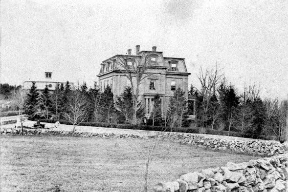
Peter Smith was one of the owners of the Smith and Dove Manufacturing Company. The estate stood until 1948 when it was demolished. Today we now know this area as the Smithshire Estates.
We pass the West Parish Church Parsonage on the right just before we come to the West Parish Church on the opposite side of the road
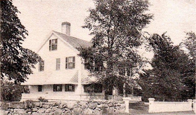
The first parsonage was located at 197 Shawsheen Road. This home belonged to Samuel Jackson, the first minister of West Parish church. When Rev Jackson retired in 1855, the deacons of the church bought his home, and it served as the parsonage for 67 years.
The walls of the West Parish Church are built of stone to the eaves, giving it the name of “the stone church”. It was built in 1826.
The roads so far have been very good although it has an uphill climb nearly all the way. Having arrived at the West Parish center from which radiate five different roads. We sat down on the veranda at Hardy’s home and admired the scenery while Mrs. Hardy very kindly served us some of her excellent ice cream.
Standing at the Easterly corner, at the Hardy’s, a clear stretch uninterrupted by forests or hills gives one a fine view of that portion of Tower Hill in Lawrence which included the water tower. Pine groves, trees in groups, and the green sides of the hill dotted here and there with fine homes lend their attraction to all.
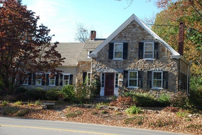
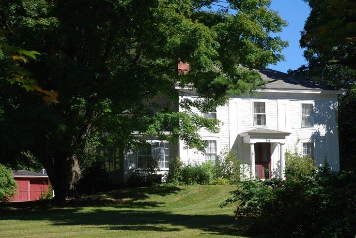
This lovely home, at 183 Lowell Street, was built in 1846 and constructed of local granite that was taken from a quarry located off Cutler Road near Oriole Drive. The West Parish Church, Chapel, and stone walls were also built from stone from the same quarry. Frank Hardy was the owner of Hardy Brush Company which was in the barn behind the house.
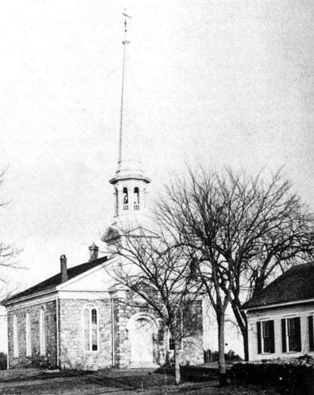
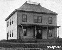
Before we proceed on our ride, we will mention the buildings located nearby. Besides the church built in 1863 and vestry, the Grange Hall is also close by and on the same side of the street as the Hardy Home.
The Grange Hall was dedicated in 1896 and was moved to 210 Shawsheen Road when William Wood needed the land to create a new entrance to the cemetery. After many different uses the grange building was razed in 1972 for a parking lot.
The old cemetery was passed next to the left.
The West Parish Cemetery was established in 1692 and enlarged in 1849, 1878, and 1908. The West Parish Garden Cemetery website has a wonderful map describing the cemetery. The original main gate was across from 215 Lowell Street.
The Paul Hunt Farm was located at 215 Lowell Street.
This address, 215 Lowell Street, was also the location of a Militia Training Ground. This farm at one point had 100 acres and included 221 Lowell Street.
Then comes the Carruth farm a little way beyond the foot of the hill. This is where Col. Sumner Carruth lived. Colonel Carruth had an honorable and praiseworthy record of service. He was colonel of the 35th Massachusetts regiment and later was Brigadier General of the 1st Massachusetts Regiment. He was wounded several times and at one time was taken prisoner by the enemy but was later exchanged.
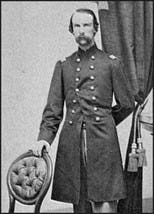
The location of Colonel Carruth’s home is near the intersection of Lowell Street and Greenwood Road. Colonel Carruth was 1of 4 brothers who were all raised on a farm in the West Parish and were served in the Civil War.
As the author continues his journey, he makes no mention of farms that he would have passed before he arrived at Bailey’s Shady Side Grove.
The Wild Rose Farm was located at 274 Lowell St which is now a housing development.
The Clover Farm was located at 309 -310 Lowell Street and became Rolling Green now the Hamilton Green Apartments and across the street is the IRS.
A bit further down the road where Raytheon is located were apple orchards and farms.
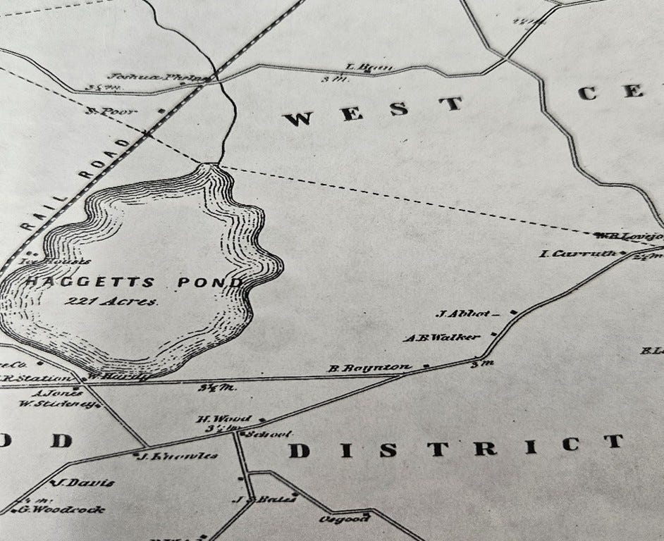
Passing the Boynton place turn in the road we soon come to Shady Side Grove on the shore of Haggett’s Pond.
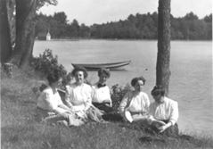
S. Gilman Bailey who lived at 381 Lowell St. was the owner of Shady Side Grove. It was a popular daytime picnic area. There was a dance hall, a bowling alley and a dining hall. In 1889 the town of Andover took control of Haggett’s Pond as its major source of drinking water and swimming was banned. However, it remained a popular summer spot for a few more years. In 1901 a fire destroyed most of the buildings and shortly after the fire, Mr. Bailey sold the property to William Wood.
Riding down into the grove we left our bikes and walked to the edge of the water in order to obtain an interrupted view. Around the shore of the pond which is almost circular in shape are cottages of several local people. To the extreme right is the cottage of W. K. Morrison of Lawrence, then comes “King Villa” owned by W.W. King also of Lawrence, Oak Bluff owned by Dr. Nathan Russell and E. N. Winslow of Lawrence, Parkhurst belongs to J. H. Campion of Andover and W.D. Currier of Lawrence in that order. Farther around the opposite shore is Cochichelwick the camp of Charles Goddard paymaster of the Lawrence Corporation and its smaller neighbor “the Wigwam” occupied by Mr. Goddard’s son, Herbert. Around to the left is B. Frank Smith “Lake View Lodge” and a boat house belonging to John L. Smith. Still farther to the left Alderman E. B. Peirce of Lowell, Hermitage, and then comes the boat landing behind which is the station. The pumping station is the Chase house located near the site of an old garrison house.
At the top of Bald Hill is the nursery of the Andover fruit farm located on land leased by B. Frank Smith for a number of years. The farm has also bought another piece of land at the foot of Wood Hill which is also under cultivation.
It was pleasant to stand in the shady pine grove and listen to the wind through the grand old pines while all one’s worries and troubles seemed to “take unto themselves wings and fly away.”
Time is flying and we still have the most interesting feature of our ride before us.
Time is flying and we still have the most interesting feature of our ride before us, to call on Paul B. Follansbee whose house and ground are located to the right across the railroad tracks at Haggett’s station on Lowell Road.
Arriving at the Follansbee estate we passed up the long winding drive from the road and found Mr. Follansbee sitting in his doorway engaged in reading the New York and Boston papers and he at once made us welcome as he is always glad to receive visitors. After a preliminary chat during which time he told us that nearly all the trees in the front had been planted by him. Particularly pointing out one huge elm which he said he carried in 1845 on his shoulder for 75 or 80 rods before planting it and telling of the squirrels which inhabited the different trees. Our host is truly a child of nature in his love for all things pertaining to it. He invited us to inspect his museum. It would take a volume to enumerate a quarter of the peculiar and valuable things to be found in this room. Suffice it to say that Mr. Follansbee has made a study and collection of stone implements belonging to the prehistoric man and to the Indians who later inhibited this continent and has hundreds upon hundreds of different kinds of stone implements, arrowheads and other curiosity which he is always willing to show to visitors.
Mr. Follansbee who is well into his eighties accompanied us on a tour of the premises. Probably not a place in this vicinity very likely not in America similar to that of our host. A pretty path starts from a corner of his greenhouse giving no hint until you have traversed it some little way of the beauties that await us on every side however as we proceed growing things seemingly of every known variety shrub, trees, climbing and running plants bestrew the path on either side in apparently endless profusion. Here there is a whole grove of maple trees that Mr. Follansbee raises for sale at the market.
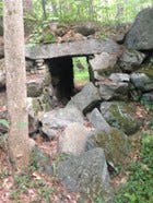
Finally, we come upon a rustic well at the side of the path with an old-fashioned well sweep. Then we came upon the rockery artificially constructed but looking very natural with its caves and nooks. This was all blasted out of the ledge at this spot and considerable labor at its present location. Near here is also the observatory reached by a winding path through the shrubby, affording from its point of advantage a charming view of Haggett’s Pond and West Parish through its rifts of trees.
In 2015 AVIS purchased the site of the “Turtle Mound” (a large stone mound of glacial field boulders) which is part of the Follansbee estate. This AVIS site is located on Lakeside Circle. The Turtle Mound is a rock garden created by Paul Follansbee and his son John. It was one of the attractions on the estate to bring customers to their nursery business.
This picture is from the AVIS website about the Turtle Mound.
While one could linger here for many hours constantly discovering something new, something strange and always something interesting we found that the noon hour was fast approaching and we must not remain longer in this enchanted nook. After a short inspection of the greenhouse, we thanked Mr. Follansbee for his kindness and took our leave, retracing our course to the town Square. The distance to Mr. Follansbee was almost 5 miles, making the entire trip about 10 miles easily within the power of almost any bike ride.
This bike ride today would certainly look different. There is the IRS, Route 93, Raytheon, churches, traffic lights, many more homes, and of course Barron’s Country Store just to name a few additions since 1899.
Thank you for reading! Please leave a comment and let me know if you have taken this bike ride, or perhaps you have additional information to add to this story.
~Barbara
Andover Townsman July 21, 1899
Andover Preservation Website
Andover History and Culture Files
AVIS
Comments
Nothing yet. Say the first thing.
Sign in to join the conversation.