
THE U.S. STATE DEPARTMENT seems to have lost its bearings,1 which is just another indicator of what happens when we rely too heavily on technology to tell us what to do and where to go.
I confess, I am as fond of GPS as the next person to get from point A to point B. Yet, when I am going nowhere, one of my favorite activities is perusing maps. Here are some of my favorite bits of cartographic trivia that may just change your perspective on what is where.
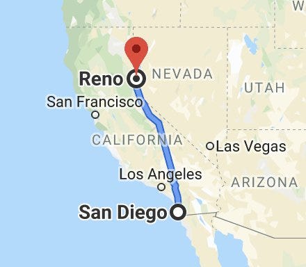
IN SAN DIEGO, CALIFORNIA, you can perambulate the sandy shores of the Pacific Ocean. In Reno, Nevada, nestled in the Great Basin Desert on the eastern side of the Sierra Nevada Mountain Range, you’d need to hike due west 200 miles (322 kilometers) to dip your toes in the world’s largest body of water. Yet, Reno is farther west than San Diego, by about 141 miles (227 kilometers). And that is why, on the West Coast, the surf is up down to the east of Reno.
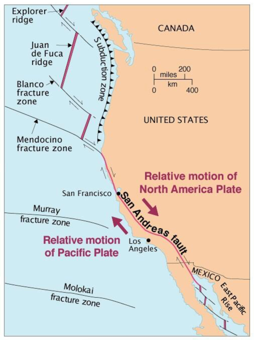
HALF OF ICELAND is a part of North America. A part of California is apart from North America. Still following me or is this where we part ways? The North American tectonic plate extends from the San Andreas Fault in California to the Mid-Atlantic Ridge, a mostly submerged mountain chain of basalt rock in the Atlantic Ocean.
There, the island of Iceland is really just a massive volcanic plateau that is elevated above sea level. One half of the land lies on the North American plate, the remainder rests atop the Eurasian plate. In the Thingvellir National Park, you can hike through a canyon that demarcates the two different plates.2
In California, the Pacific Plate and the North American Plate meet up at the infamous San Andreas Fault,3 which separates the state longitudinally for 800 miles (1,300 km) from Cape Mendocino to the Salton Sea.
There are residents in Daly City (just south of San Francisco) who can wave to neighbors on another tectonic plate. Palmdale and San Bernardino in the southern part of the state also sit astride the fault, and these three municipalities are the only cities in the world with over 100,000 inhabitants that are divided in such a manner.4
The San Andreas can extend up to six miles (10 km) deep into the mantle and span a few meters to two kilometers in breadth. This meandering seam in the earth, however, doesn’t split the Golden State neatly in two. It is akin to an artery, with about a dozen or so faults branching off as veins, and thousands of capillaries linked to those veins. They are all fractures-in-waiting of different magnitudes and time schedules.
The entire San Andreas Fault System (SAFS) covers an area of 10.2 million acres (4.1 million hectares), a little larger than the size of Switzerland. Some 90 percent of the earthquakes in California — of which I’ve experienced more than my fair share5 — are a result of the activity of this system.

What’s driving it all, though, is the determination of those larger lithospheric masses — the Pacific and North American plates — intent on going their separate ways. As a result, the sliver of California along the coast is inching toward Alaska, while the rest of the state is ambling more or less to the southwest. In a mere 11-15 million years, Los Angeles (on the Pacific Plate) and San Francisco (on the North American plate) will be at the same latitude. I’m not sure how that will affect real estate prices.
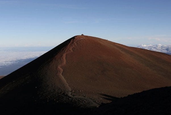
WHEN MEASURED FROM base to peak, a dormant volcano in Hawaii is the highest mountain in the world. Mauna Kea reaches 33,000 feet, or over six miles (10 kilometers) vertically. Of course, the peak known to Westerners as Mount Everest — but to the Nepali as Sagarmatha, which means “forehead of the sky”6 — still takes the prize for the highest ascent above sea level. Even then, Mauna Kea is no slouch, with 2.5 miles (4 kilometers) rising above the surface.
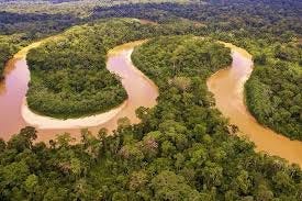
THERE ARE 165 MAJOR RIVERS in the world. Of all that fresh water released, the Amazon accounts for 20 percent of the volume. That is more than the next seven largest rivers combined. The Amazon River’s discharge equals 4.77 trillion gallons (18 billion cubic meters) per day, enough to fill Lake Erie in that time frame (25 to 26 hours, to be more precise).
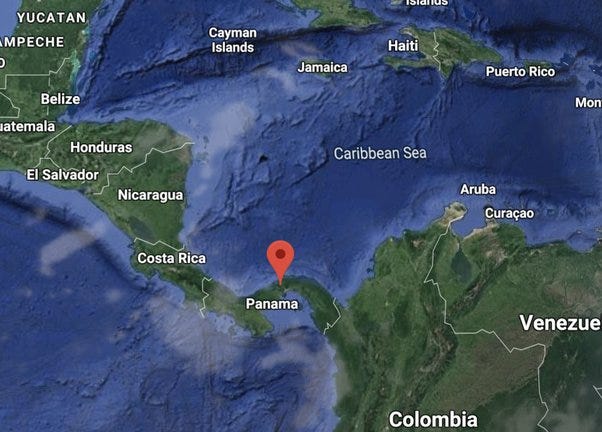
THE PANAMA CANAL is one of the most amazing feats of human construction, especially given the time frame when the project was completed, over 110 years ago.
Let us suppose you want to travel through this testament to human ingenuity, from the Atlantic Ocean to the Pacific Ocean. In which direction would you be moving?
East to west? Not quite. Actually, not even close. You would be heading southeast. The isthmus through which the canal was carved takes an abrupt turn before connecting the Americas.
THE CLOSEST POINT BETWEEN the continental United States and Africa is not in Florida. You may be thinking that there’s some sort of catch, that you would have to travel south to some remote island in the Florida Keys. For Florida, that would be true, sort of. It is an island off the Florida coast, but not part of the Keys. The closest point in the Sunshine State to Africa is at Singer Island, in Palm Beach County, separated by 4,085 miles (6,574 kilometers) from El Beddouzza, Morocco.
For the closest point between the U.S. and Africa, you need to head north, all the way up to Maine. (And if you are not thoroughly confused yet, consider that once upon a time sailors in Boston referred to Maine as “down east.”7 ) On the shore of West Quoddy Head in the town of Lubec, Maine, you stand a mere 3,154 miles (5,075 km) from El Bedouzza.
Now, you may be asking yourself: If there is a West Quoddy Head, shouldn’t there be an East Quoddy Head? And wouldn’t that be closer still? Yes and yes. But East Quoddy Head is not in the States. It’s in Canada.
But wait, there’s more. If you continue farther north in Canada, the closest point between Africa and the North American Continent is in New Foundland, where the town of Cape Spear is separated from El Beddouzza by a mere 2,431 miles (3,912 km). That’s about half the distance of the closest point in Florida.
Cape Spear also holds the distinction of being the first place in North America to greet the sunrise.8
WEST AND EAST Quoddy may be separated by an international border, but consider this: the city of Istanbul is bifurcated by the Bosphorus Strait, the boundary between Europe and Asia. It is the largest but not the only metropolitan region with the distinction of spanning two continents. The city of Suez, Egypt, straddles the African and Asian land masses.9
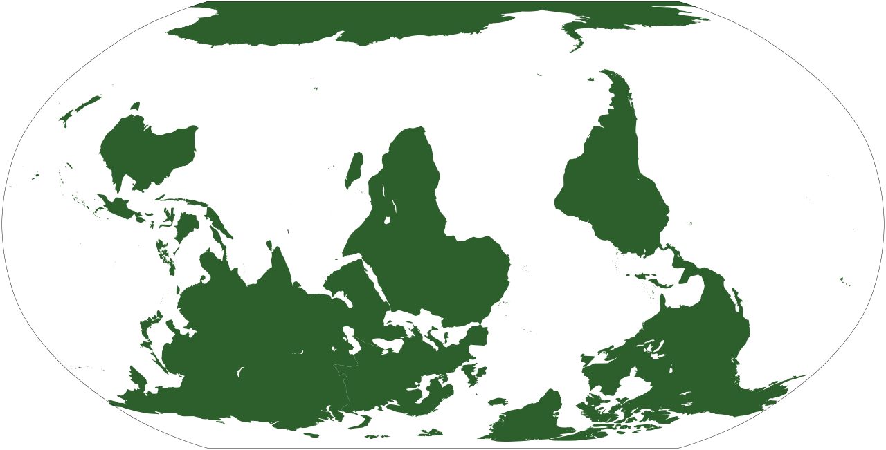
AND FINALLY, I WOULD be remiss if I didn’t point out that, even though I am referring to places in the north as “up” and places to the south as “down,” there really is no such thing, relative to space.
That concludes my fun facts for today, which are collectively worth their weight in Bitcoin, and intended soley to provide a momentary diversion from witnessing the collapse of the world in real time, all via your smartphone. You may now resume doom scrolling.
First and foremost, thank you for taking the time to read this article.
Subscription is free and always will be. I do not want your money.
Now, on the other hand, if you don’t want your money either, feel free to donate to one of your favorite causes, and tell them I sent you. If you’re looking for a charity to support, I recommend this GoFundMe campaign to help victims of the earthquakes in Venezuela. It is run by a friend in Caracas. Any amount will help. Thank you.
During an AIDS conference in Rio de Janeiro in July 2026, the U.S. State Department displayed a map of Africa that mislabeled virtually every country on the continent.
The country of Iceland also includes about 30 other islands, only four of which are inhabited. The main island contains 99.5% of the country’s population. Greenland and parts of Siberia — the territory located east of the Chersky Range — are also part of the North American plate.
For more on the San Andreas Fault, check out this field guide by David K. Lynch.
If you include the suburbs of the greater metropolitan region of Reykjavik, Iceland, it would also qualify as being bifurcated by two major tectonic plates: the North American and Eurasian plates. It should also be pointed out that Tokyo, Japan, with 33 million residents, is situated atop four fault lines layered over each other — the Pacific at the bottom, the Philippine in the middle, and then the Eurasian Plate sharing top spot with the Okhotsk Plate, but there is no vertical “wall” separating them. The fault lines are situated in somewhat of a stair-step pattern.
I was in San Francisco when the deadly 6.9 magnitude Loma Prieta Earthquake hit in October 1989. I was in Los Angeles in July 2019 to experience the 7.1 magnitude Ridgecrest temblor. I have rode out too many earthquakes to count during my 40 years in the state, but the first shaker I ever felt was in Portland, Maine in 1979. It was a 4.0 magnitude and the epicenter was a bit north, in the town of Wiscasset, the site of a nuclear power plant.
The compound Sanskrit word sagarmatha can be broken down to Sagar (सगर), meaning “atmosphere” and Matha (माथा), meaning “top” or “forehead.” Tibetans and Sherpas refer to Mt. Everest as Chomolungma, meaning Mother Goddess of the World.
The term “Down East” was coined by sailors in Massachusetts in the 18th century to refer to Maine, as well as the maritime provinces of Novia Scotia, New Brunswick, and Prince Edward Island, because the prevailing breezes to reach those destinations was downwind, and, of course, to the east.
In the continental United States, the first place to accept the sun’s rays alternates between three spots in Maine: West Quoddy, Cadillac Mountain in Arcadia National Park, and Mars Hill (also a mountain peak). I’ve seen the sunrise atop Cadillac Mountain. It’s quite spectacular.
There are three cities in Russia that straddle the Ural River, which some cartographers consider the natural point of separation between Asia and Europe. Not all agree about the Ural River as the boundary, however. National Geographic considers the Emba River in Kazakhstan as the continental divider. To be clear, these cities straddle geopolitical lines, not geological. Experts in the earth sciences consider Europe and Asia as one continent.
No posts
Comments
Nothing yet. Say the first thing.
Sign in to join the conversation.