
New Zealand is back in the freezer, with fresh snow warnings, widespread frost and another closure of the Desert Road.
The latest polar southerly sent temperatures plunging Monday: Aoraki/Mount Cook fell to -8C (17.6F), Tekapo to -5C (23F) and Queenstown to -4C (24.8F); and snow shut the Desert Road (SH1) between Rangipo and Waiouru.
Looking ahead, MetService issued another Desert Road snowfall warning Tuesday, running from 9am through 3am Wednesday.
The chill extends well beyond the mountains. MetService says persistent southerlies are drawing cold air directly from the Southern Ocean, with widespread overnight frosts and possible black ice across parts of the country.
Westerlies should bring a temporary moderation Friday, but the polar boundary is forecast to return to the South Island over the weekend.
This all comes barely ten days after New Zealand’s exceptional early-August freeze, when Taumarunui dropped to -7.2C (19F)—its coldest temperature on record—and Rotorua hit a new all-time low of -5.6C (21.9F).
Winter, evidently, still has plenty left in the tank.
The extraordinary summer chill north of 80N has persisted deep into August.
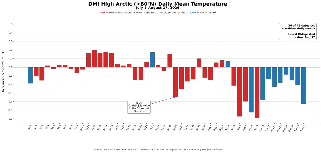
An audit of the Danish Meteorological Institute’s High Arctic temperature series finds that 36 of the 48 days from July 1 through August 17 set record-low daily means for their respective calendar dates—75% of the period.
One striking reading came on July 26, when the mean fell to -0.347C—the coldest July value in the DMI record:
This all follows a record-smashing June:
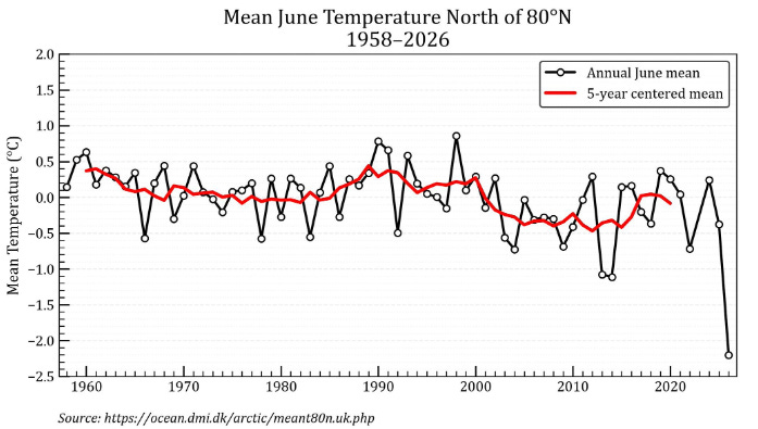
The run of daily records has eased since August 9, but the broader freezing summer trend remains. 2026 is on course to become the High Arctic’s coldest summer on record (data back to 1958), potentially by a substantial margin.
The climate-change machine that dominated academia, politics and policy for decades is showing signs of exhaustion.
Comments
Nothing yet. Say the first thing.
Sign in to join the conversation.