
On August 26, a catastrophic flash flood tore through the Nepal-China border region after a huge ice-rock avalanche—perhaps a large section of a glacier—crashed into the Lhende Khola. This mountain debris temporarily blocked the river before a violent surge of water, mud, and boulders ripped downstream. The result was tragic. Reuters is reporting at least 95 dead in Nepal, while the Associated Press puts the combined Nepal-China toll at at least 98, with hundreds still missing (as of 12:50 pm 8/26). More than 300 of those unaccounted for are foreign travelers, and rescue teams are still struggling to reach areas cut off by destroyed roads, bridges, power lines, and communications. Given the number still missing and the difficulty of reaching entire stretches of the valley, the death toll is very likely to rise.
The immediate cause of the disaster was local: part of a Himalayan glacier collapsed into a river and unleashed a devastating flood. But the event also provides a vivid example of the much larger tectonic forces that make the Himalayas one of the most violently active geological regions on Earth—and it happens to bear directly on my latest project, a plate-tectonic map-calculator that puts special focus on the Himalayas.
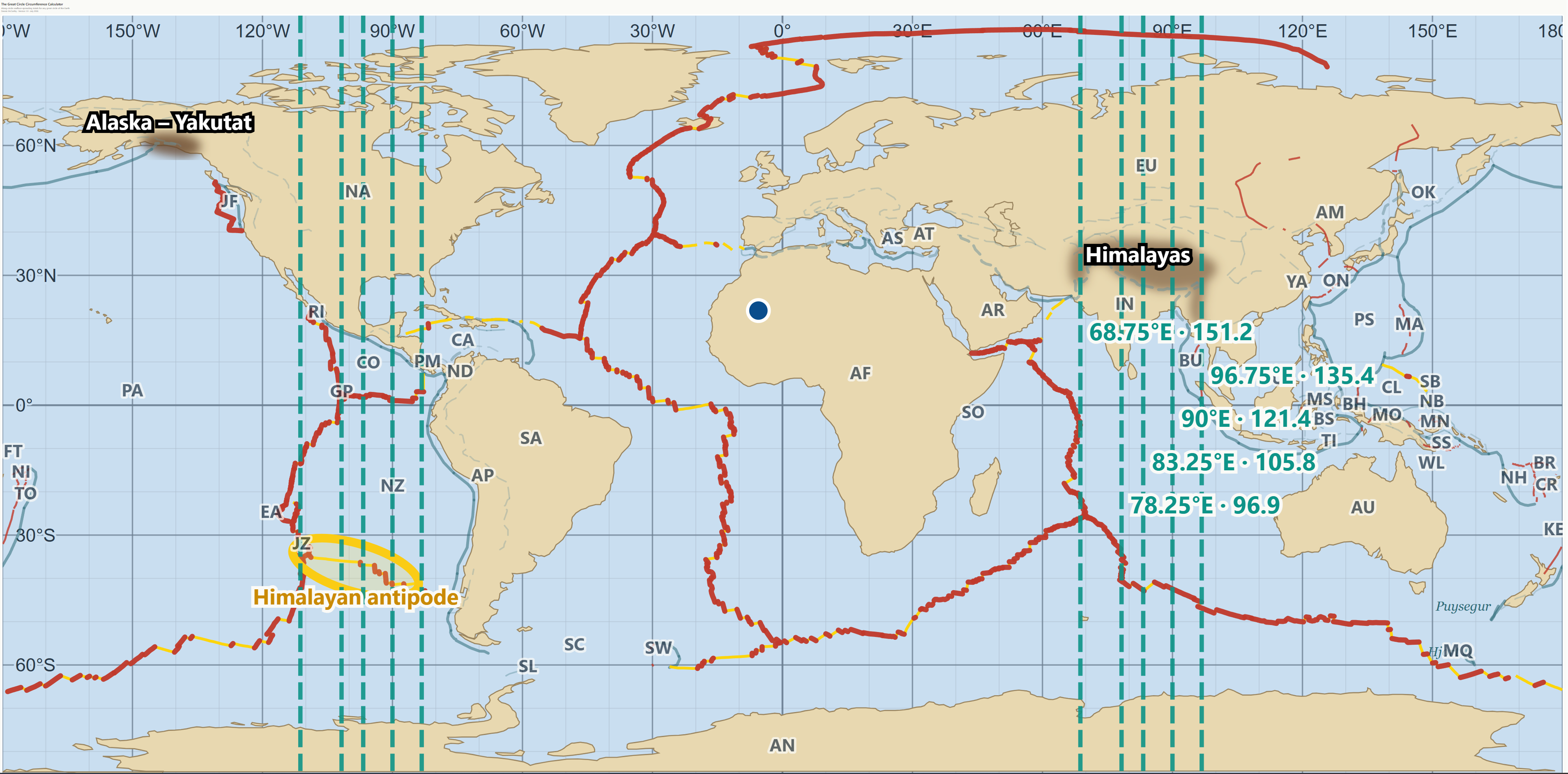
I created the calculator as a companion to an article I have been writing for The Journal of Geophysical Research. It traces individual great circles around Earth and totals the spreading and convergence rates—in the direction of that great circle— encountered at every plate boundary. Because Earth maintains an approximately spheroidal shape, this is not an optional balance: Extension that adds too much seafloor along a great circle must ultimately be offset by shortening elsewhere along that same circumference.
What is remarkable is where the largest north-south spreading totals occur. As seen in the map above (a screenshot from the map calculator), the longitudinal great circles passing through India, Nepal, Tibet, and the Himalayas show the highest north-south spreading rates around those same circumferences—in some cases roughly 100 to 150 mm/yr. Somewhere along these longitudinal great circles, all this extreme emplacement of new crustal material year after year requires compensation.
The problem?
The problem is that there are not enough deep-sea trenches along these longitudes to absorb it all through ordinary oceanic subduction, where dense oceanic lithosphere can sink back into the mantle. So a large part of the compensation is occurring on land, where India is being driven into Eurasia and two buoyant continental masses are crushing together.
The result is the highest mountain ranges and most intensely deforming continental regions on the planet. The Himalayas are, in effect, taking up an extraordinary amount of crustal shortening that elsewhere would more commonly be accommodated at oceanic trenches.
The physical consequences are immense. The collision is continually thickening and fracturing the crust, driving uplift, generating powerful earthquakes, and creating slopes of extraordinary steepness and instability. The mountains are not static monuments. They are part of an active deformation zone, and that persistent deformation helps explain why this region is so prone to earthquakes, landslides, rockfalls, glacier collapse, and catastrophic debris flows.
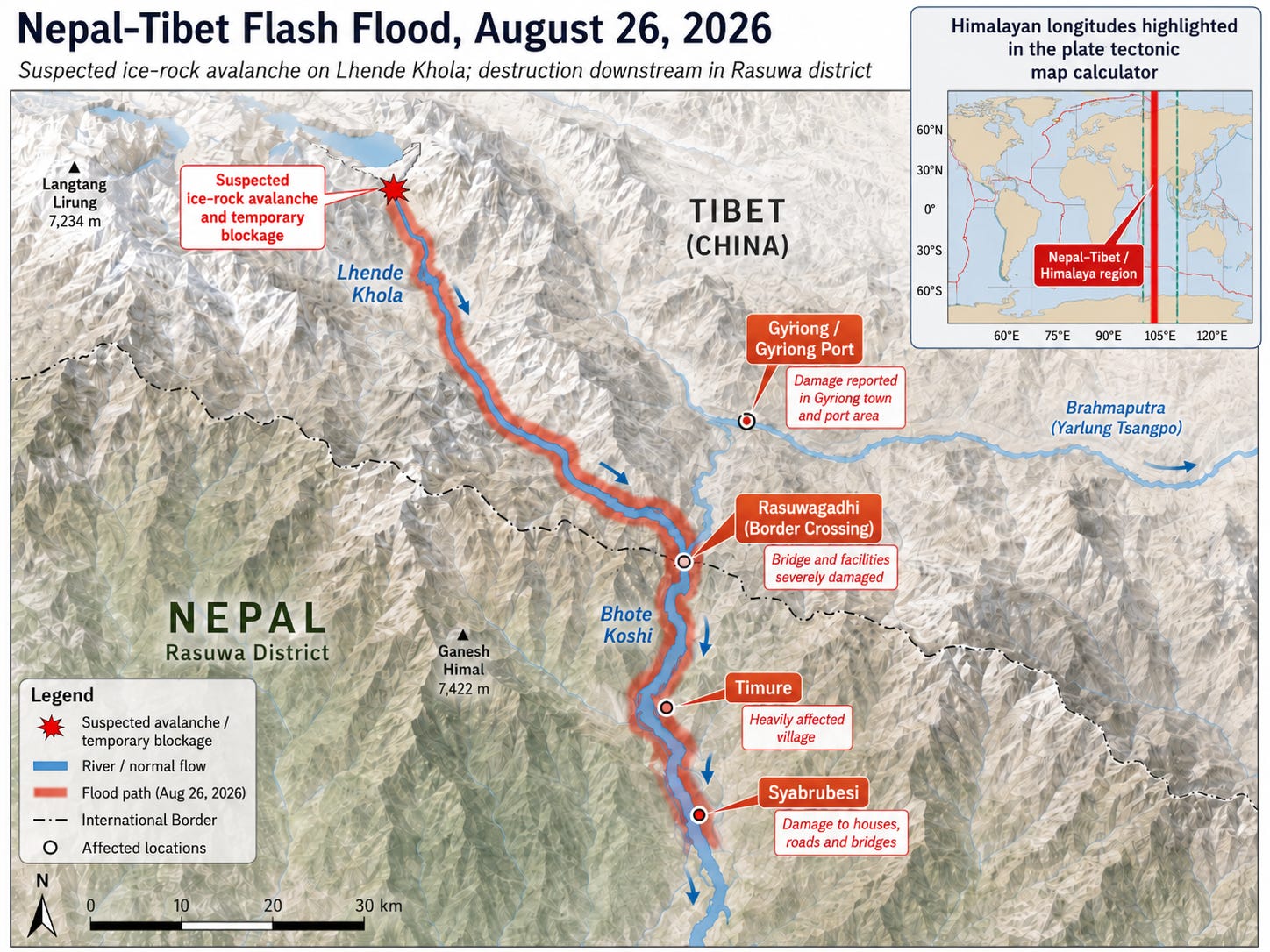
The Nepal-China flash flood was one horrifying expression of this larger global tectonic system. While initial reports suggested an earthquake may have caused the landslide, it turns out that it was the ice-rock landslide itself that generated the long-period seismic waves that some had assumed was an earthquake. But that does not mean the landslide or crumbling glacier was unrelated to plate tectonics. The extreme height of the Himalayas leads to glacier development at higher elevation, and its jagged steepness can promote collapse. Likewise, a Nature Geoscience study mapped more than 15,000 Himalayan landslides and found that landslide erosion is directly coupled to tectonic rock uplift and river incision. In rapidly uplifting terrain, slopes approach a critical or “threshold” steepness; further uplift and river incision are then accommodated increasingly through landsliding rather than indefinitely steeper slopes.1
The immediate trigger for the flash flood was an ice-rock avalanche into the Lhende Khola, but the landscape in which that avalanche occurred is being shaped by global forces. Exceptionally high north-south spreading along mid-ocean ridges must be balanced by convergence along those same circumferences, and an extraordinary share of that convergence is concentrated in the India-Eurasia collision zone. The flood was a local disaster occurring within a landscape continually stressed and reshaped by global plate motions.
Isaac J. Larsen and David R. Montgomery, “Landslide Erosion Coupled to Tectonics and River Incision,” Nature Geoscience 5 (2012): 468–473. https://doi.org/10.1038/ngeo1479.
Comments
Nothing yet. Say the first thing.
Sign in to join the conversation.