
If you’ve ever walked along a five-foot sidewalk separated from four lanes of 45-mph vehicular traffic by only a narrow strip of grass, you’ve experienced the fundamental flaw of legacy suburban road design. 🛣️Strong Towns calls this a “stroad” :
For decades, standard engineering manuals operated on a simple principle: prioritize vehicular throughput, apply rigid lane-width templates, and attempt to calm traffic after the fact. 🚗💨
As Manheim Township moves forward with implementing the Rooted & Renewing 2035 Comprehensive Plan, adopted in September 2025, an important issue is: 🧭 How do we transform corridors like Lititz Pike (Route 501) and Oregon Pike (Route 272), connect our village cores, and manage growth without repeating the auto-centric mistakes of the late 20th century? This is complicated because some roads are maintained by PennDOT, others by Lancaster County, and the Township.
The answer is collaboration and Context-Based Design (CBD). 📐
Context-Based Design—often integrated into Context-Sensitive Solutions (CSS)—flips traditional roadway engineering on its head. 🔄 Instead of forcing a one-size-fits-all cross-section onto every arterial or collector, CBD starts with a simple question: What is the surrounding land character, and how should the street serve the people living, working, and walking there? 🏡🚶♀️
Under a context-driven framework:
🎯 Target speed replaces design speed. Roads aren’t built wide to accommodate speeding; they are engineered with visual cues, narrower lanes, and tight corner radii to naturally enforce safe speeds. 🚘
⚖️ Access balances mobility. In dense commercial hubs or residential centers, pedestrian accessibility, micro-mobility, and public space take priority over peak-hour Level of Service (LOS) for vehicles. 🚶♂️🛴
🌳 Rights-of-way adapt. Sidewalks, sidepaths, street trees, and bike lanes are tailored to the specific “transect” or character zone they pass through. 🌿
We don’t need to reinvent the wheel. We can look to proven frameworks from other state highway agencies and right here in our own backyard: 💡
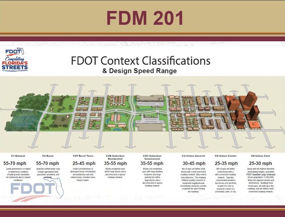
☀️ Florida DOT’s Context Classification System: FDOT replaced binary urban/rural labels with an 8-Zone Context Matrix (C1-C6). A corridor running through a rural town (C2T) gets a completely different design kit—lower target speeds, curb extensions, wide sidewalks—than an urban highway or industrial park. 🏞️

Source: Florida Department of Transportation 🦀 Maryland DOT SHA’s Context-Driven Guide: MDOT utilizes Short Trip Opportunity Areas (STOAs). By mapping areas where non-motorized short trips naturally occur (near schools, transit hubs, and commercial centers), MDOT gives planners and engineers explicit policy clearance to prioritize active transportation over vehicular delay. 🏫
🛣️ PennDOT’s Smart Transportation Guidebook: Developed jointly with NJDOT, PennDOT’s guidebook formalizes context typologies (Rural, Suburban Neighborhood, Suburban Corridor, Suburban Center, Town/Village). Crucially, it provides policy justification for 10- to 11-foot lanes in town centers and suburban corridors, sets target operating speeds based on the desired land-use context, and integrates accommodations for Plain Community non-motorized travel (horse-and-buggy shoulders and multi-use sidepaths). 👨🌾🛞
📍 Lancaster County Planning Commission (places2040 & Complete Streets): Lancaster County’s places2040 plan and Complete Streets Guidebook emphasize building “complete places, not just moving vehicles.” The County’s Active Transportation Plan (ATP) specifically targets suburban retrofits along corridors like Lititz Pike to turn commercial strips into multimodal avenues. 🚲
🏙️ City of Lancaster Complete Streets & SALDO: The City of Lancaster became the first local municipality to adopt a formal Complete Streets policy. It embedded Complete Streets requirements directly into Article VIII (Traffic and Transportation) of its Subdivision and Land Development Ordinance (SALDO)—requiring private developers to build interconnected, context-sensitive multimodal networks and green infrastructure (bioswales, rain gardens) by default. 🌧️🌱
Manheim Township’s Rooted & Renewing 2035 plan lays out clear mandates for our transportation network:
🚸 Enhanced Multimodal Safety: Filling gaps in pedestrian and cycling networks.
🏡 Village Core & Hub Connectivity: Reconnecting historical centers like Neffsville and Oregon Village, as well as active corridors near the Lancaster Amtrak station / Northern Gateway. 🚆
📑 Proactive Growth Management: Aligning municipal land development ordinances with land use goals via the Future Character Area Map (FCAM) and Official Map. 🗺️
These goals cannot be achieved using outdated subdivision and road/streets design standards. To turn Rooted & Renewing 2035 into reality on the ground, Manheim Township should look at three immediate implementation steps:
Township staff and the Comprehensive Plan Implementation Committee (CPIC) should map MHT roadways against our Future Character Area Map. A road running through a Traditional Neighborhood or Mixed-Use Corridor must automatically trigger PennDOT Smart Transportation design controls like 10-foot lanes, street trees, and protected sidepaths. 🌳🚲
Following the City of Lancaster’s ordinance model, we should update Article VIII of MHT’s Subdivision and Land Development Ordinance (SALDO). Incorporating Context-Based Design parameters ensures that private developers build context-appropriate infrastructure and green stormwater management by default—rather than relying on ad-hoc negotiations or variance requests. 🏗️
Let’s adopt MDOT’s STOA methodology and Lancaster County’s Active Transportation Plan locally. By mapping 1-mile radii around our schools, township parks, and commercial clusters, MHT can target high-visibility crosswalks, traffic calming, and grant funding where active transportation trips naturally occur. 🚶♀️🎒
A shift toward Context-Based Design isn’t just a technical exercise for engineers and public works staff. It requires:
🏛️ Elected Officials & Commissioners who understand that lowering target operating speeds protects residents and yields higher economic productivity. 📈
🛠️ Staff & Consultants empowered with performance-based design tools, PennDOT Smart Transportation, the National Association of City Transportation Officials (NACTO), and US Federal Highway Administration (FHWA) flexibility guides. 📓
📣 Residents are equipped with walk audit toolkits from the American Association of Retired Persons (AARP) and interactive section generators (like Streetmix) to provide constructive feedback during public hearings. 📱💬
Street design is land use in motion. 🛣️ If we want Manheim Township to be a vibrant, connected, and safe community in 2035, we need to stop designing our streets for cars passing through and start designing them for people who live here. 🏘️❤️
🏙️ NACTO - City Limits: A consistent, scalable approach to setting safe, context-appropriate speed limits.
🏡 AARP Livable Communities: Information, walk audit toolkits, and inspiration for local leaders so communities can be livable for people of all ages.
🚲 Blue Zones - Road Diets: Repurposing streets to enhance safety, active transportation, and neighborhood health.Other Resources:
Comments
Nothing yet. Say the first thing.
Sign in to join the conversation.