
Happy Saturday! I wanted to use the release of the latest Debris Ballers podcast episode yesterday that I contributed to as an opportunity to take another look at the growth of artificial intelligence (AI) and machine learning (ML) in meteorology. The episode focuses on the July 27th Appleton, WI tornado. As part of the discussion, we also talked about the Nadocast AI severe weather forecast system, which I highlight frequently in this podcast as it produces quite skillful severe weather probabilistic forecasts.
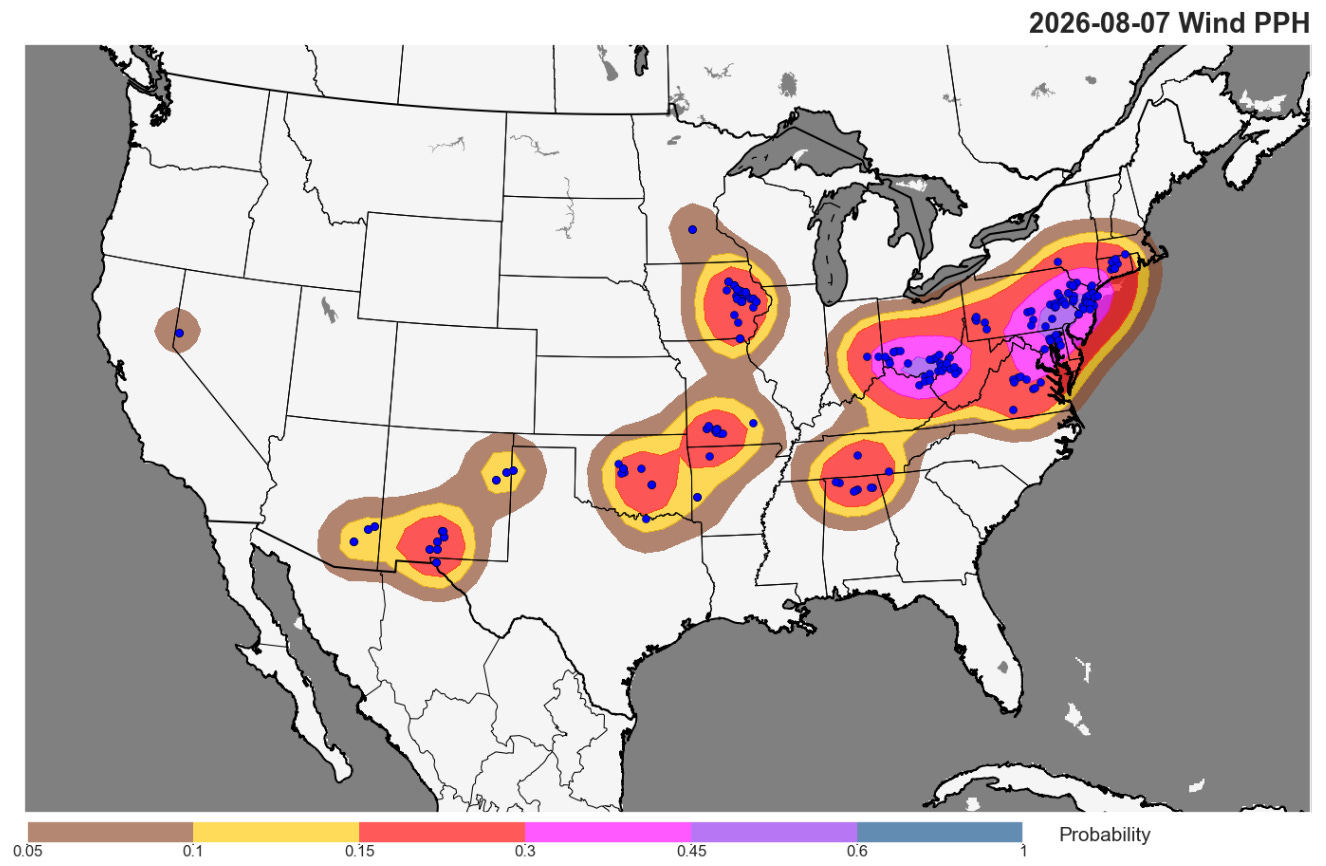
An example of Nadocast’s utility came just yesterday. It was a relatively active day of severe weather across the country, with over 300 reports of severe weather. Severe storms moved through the New York City tri-state area around rush hour, downing trees and powerlines and knocking out power to tens of thousands of customers per PowerOutage.us.
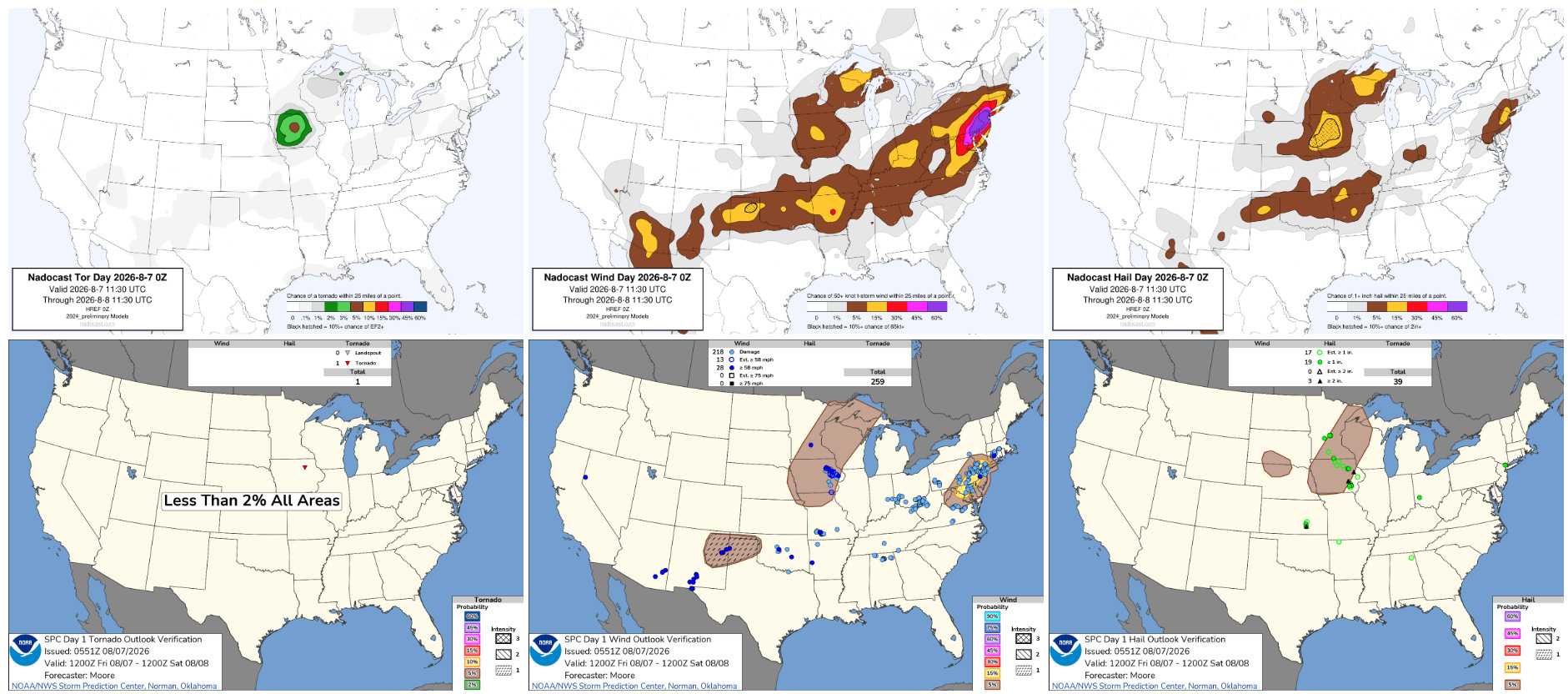
While certainly not perfect, Nadocast probabilities did a decent job of identifying the severe wind potential in the Mid-Atlantic — along with other areas of severe storms farther to the southwest across the Ohio Valley, Mid-South and Southwest.
I have been looking at Nadocast pretty much every day for the last couple of years. It certainly has its biases — being trained on storm reports, it can overdo probabilities in areas of high population where reports are more numerous and underdo probabilities in low population areas. It can also show too high of focused probabilities in areas of severe weather threat with nebulous atmospheric forcing — similar to yesterday across much of the US.
There are now a number of AI/machine learning based severe weather forecast systems, including systems developed by scientists at the National Center for Atmospheric Research (NCAR) and Google DeepMind GDM). While these AI severe weather forecast systems have not been the breakthrough the GDM tropical cyclone forecasting system has been — that model had the best forecast skill in the Atlantic basin last year — there is no doubt in my (and other meteorologists I talk to regularly) mind that these systems are producing useful guidance. For example, for yesterday’s severe weather the various AI systems in the previous days gave me a good indication that Friday would be an active day, as well as some of the general areas I should be focused on. We discussed in the Debris Ballers podcast how on the day of the Appleton tornado, Nadocast gave solid signals of the enhanced tornado risk across Wisconsin and northern Illinois.
We also discussed in the podcast that the future of Nadocast is uncertain. The NWS is on the cusp of making a major change to its short term, high resolution ensemble forecast system, moving from the High Resolution Ensemble Forecast system (HREF) to the REFS system. Nadocast was trained on the HREF, and while I understand that a version of Nadocast essentially just running using REFS as input instead of the HREF was tested with some success in the NOAA Hazardous Weather Testbed (HWT) this spring, how skillful this approach might be is quite unclear.
To me, this is an example of the massive evolution that the field of meteorology is starting on — and our potential lack of readiness for it. While AI/ML generated severe weather forecasts are not yet ready to fully “take over” forecast production, in my opinion these skillful early efforts show that with additional years of focused development, that is clearly the direction we are headed.
Right now, though, as far as I can tell there is no “focused” development — the various efforts are happening in many different groups in the public, academic and private sectors. I have little doubt that the private sector is going to continue to push forward aggressively with their development efforts. To me, the public sector, i.e., NOAA, needs to very quickly spin-up some sort of focused organization with a focus on coordinating and leveraging AI/ML development efforts to benefit public weather forecasts and warnings. Perhaps entities within NOAA such as the NOAA Center for AI are farther along in this than I realize — but even if so, it seems to me given the rapid progress being made across the weather enterprise, these needs to be an (the?) absolute top priority for the agency.
While the community is working to get its arms around the development aspects of AI, I think those of us making forecasts and communicating weather information to the public need to be working to better integrate guidance from the current AI forecast systems into what we do. At a minimum, anyone who is communicating severe weather forecasts should be looking at the AI guidance as a routine part of their forecast process and taking it into account
And it is not just severe weather forecasts. Systems like NOAA/CIMSS ProbSevere, NSSL/CIWRO TORP, and StormNet are producing useful guidance today that can help meteorologists with severe weather warnings. Warning-scale automated guidance such as this has been in development at NSSL and evaluation in the HWT for more than a decade, and has been showing potential to improve severe weather warnings for at least 10 years.
The skill of these ML based systems has continued to improve in the last decade, and as I discussed in this recent Debris Ballers podcast, ProbSevere tornado probabilities in the hour prior to the (initially unwarned) Appleton tornado were showing high levels (45-60%) that were concerning. To me, we are doing the public a disservice by not utilizing these systems more aggressively in the NWS warning program — at a minimum to help forecasters identify and analyze storms of heightened concern. All of these systems generate real-time guidance that is available publicly — what is needed is a coordinated effort to integrate it into operations and to train meteorologists in how to utilize it and encourage its use.
I have been deeply involved in operational meteorology for almost 40 years, and I have very little doubt that we are on the verge of a transformative decade as to the skill of forecasts and warnings due to AI/ML. I think human meteorologists will continue to play a critical role as this transformation happens — but their role will change dramatically. Operational meteorologists will play much more of a role in communicating and contextualizing this AI/ML guidance rather than actual forecast production — and the role of research and development meteorologists in maintaining these AI/ML systems and conducting research in support of new science and techniques will grow. As I said, I think the private sector is already fully heading down this road. If these new forecast and warning systems are to fully benefit the public, the academic and private sectors will need to as well.
Programming note: I am posting semi-regularly again — but family commitments and travel after the passing of my mom will mean those posts will not be as frequent or consistently timed as they typically have been.
Balanced Weather is made possible by the generous support of paid subscribers, who as thanks get access to live Balanced Weather chats and videos as well as the ability to post comments and ask questions on posts. To become a paid subscriber or a free subscriber (also very much appreciated and you will automatically receive new posts in your email), please click below.
Comments
Nothing yet. Say the first thing.
Sign in to join the conversation.