
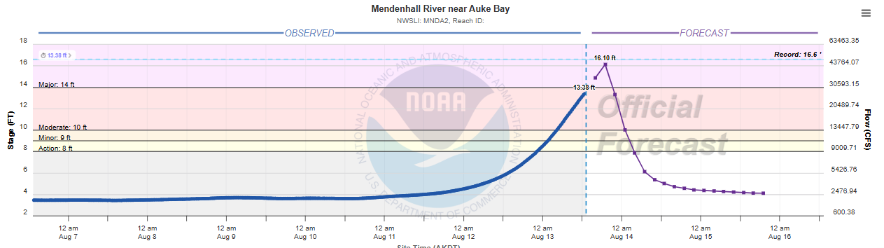
Starting off today with a quick update on the glacial outburst flooding impacting Juneau. The glacial lake in the Suicide Basin arm of Mendenhall Glacier continues to drain into the Mendenhall River, and the river continues to rise, now approaching major flood stage at the gauge near Juneau. The crest is anticipated to occur in the next several hours and has been lowered slightly to around 16.1 feet, about a half a foot below the record reached in last year’s glacial outburst.
Roads and bridges in the anticipated flood zone have been closed and evacuations of homes urged. Officials have again constructed flood barriers to help reduce flood impacts as was done in 2025. Federal, state and local leaders are working on potential long term solutions to mitigate the now annual glacial outburst flooding, including the potential for the Army Corps of Engineers to dig a tunnel that would drain Suicide Basin as Sen. Lisa Murkowski discussed with media in Juneau on Wednesday.
After a very busy few days of severe weather and flash flooding, last night saw a large complex of strong thunderstorms move across Iowa, producing widespread heavy rainfall and some strong wind gusts including a few reports of damaging winds. That complex is now moving east-southeast toward central Indiana and get ting some intensification from daytime heating. A severe thunderstorm watch is now in effect — and a sight (level 2 of 5) risk of severe storms including damaging winds, large hail and a few tornadoes will exist with these storms into southwest Ohio.
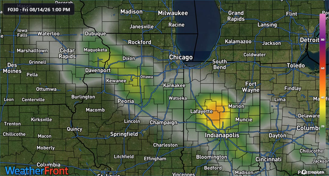
Heavy rainfall and flash flooding may be even a greater concern. The morning high resolution ensemble forecast (HREF) shows relatively high probabilities of areas of 5+” rainfall across the entire region from eastern Iowa through southwest Ohio through Friday morning (above) as this complex and other storm clusters develop and move through.
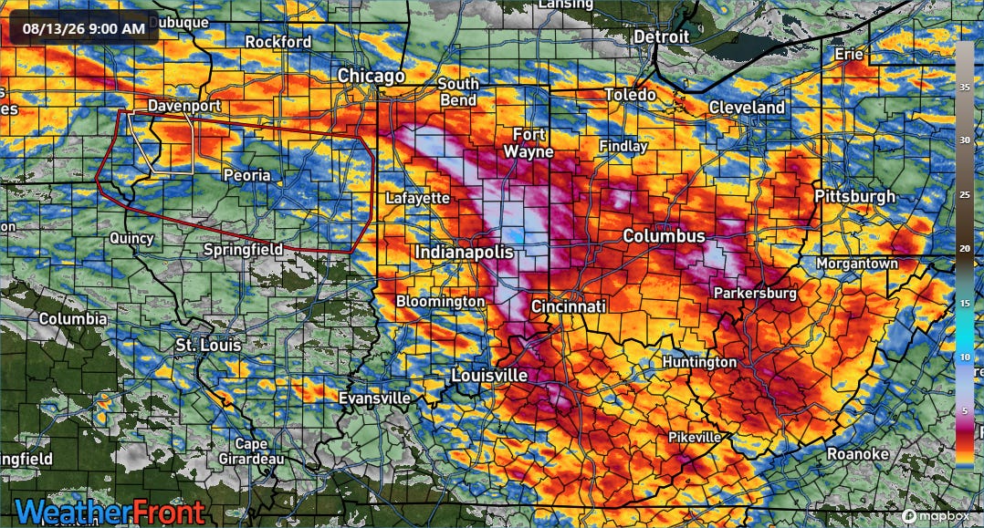
This region has been impacted by heavy rain and flooding this week — particularly parts of Indiana where the MRMS multi-sensor 72 hour rainfall estimate (above) shows a large swath of 5 to as much as 11” of rain. Serious flooding has impacted east central Indiana as I discussed in yesterday’s newsletter, and a number of rivers in the region are in major flood stage.
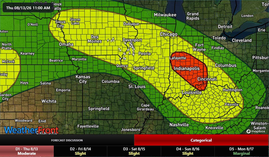
The anticipated additional heavy rainfall over the next 24 hours will likely cause additional (potentially significant) flooding impacts, and a moderate (level 3 of 4) risk of excessive rainfall is in place across much of Indiana through tonight.
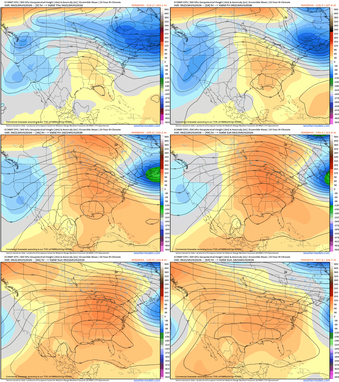
The overall pattern of an intense dome of high pressure centered across the south central and southeast United States will be lasting into early next week — and as a result the general setup of clusters of strong thunderstorms rotating around it across the Midwest, Ohio Valley and central Appalachians will continue.
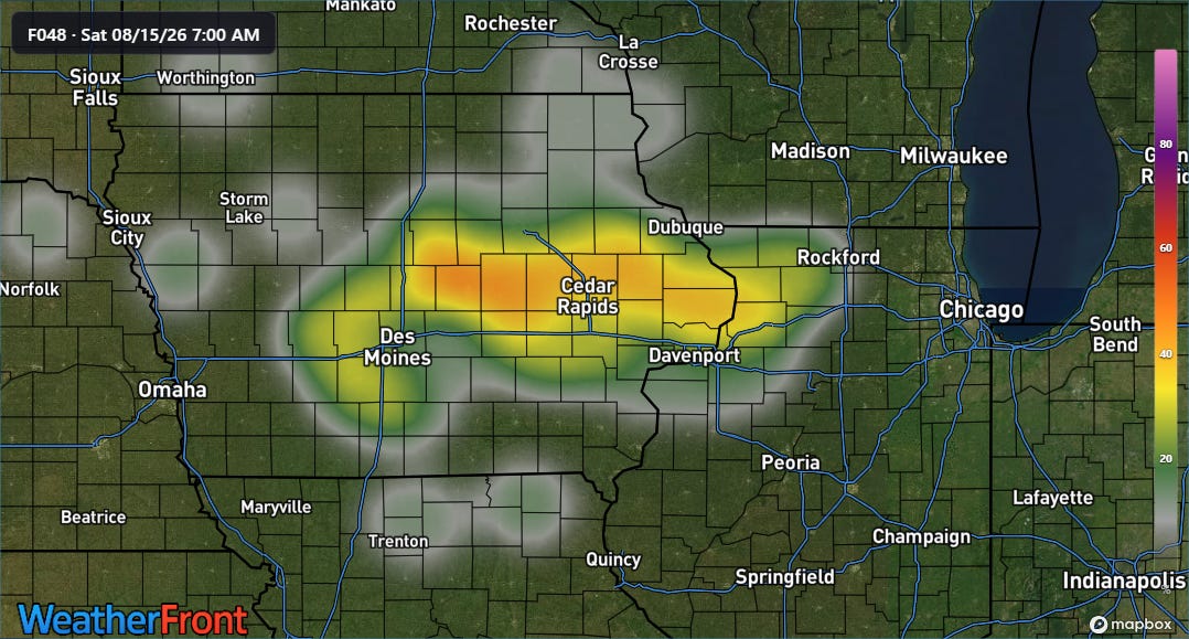
The morning HREF shows significant probabilities of 5-inch plus rainfall across Iowa and northern Illinois Friday into Friday night (above), which given recent rains could cause flash flooding.
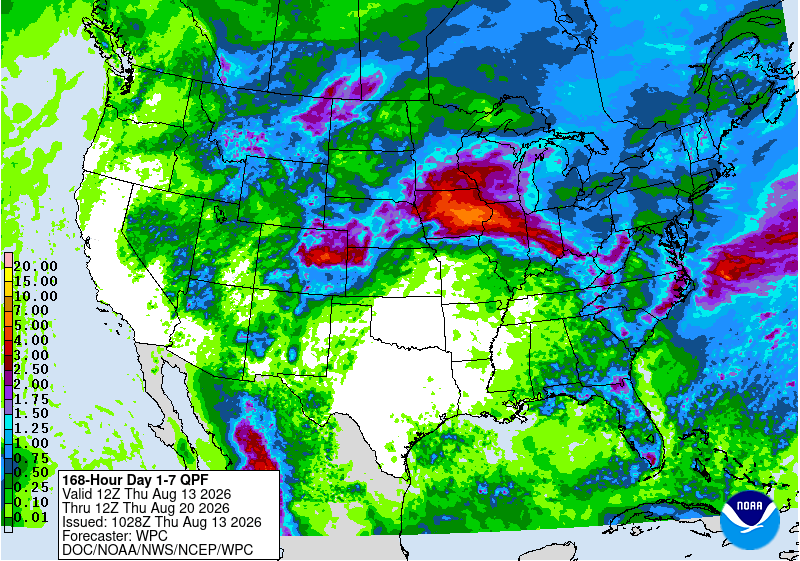
Monsoonal moisture will also bring some risk of heavy rainfall and flash flooding to parts of the Rockies and Southwest.
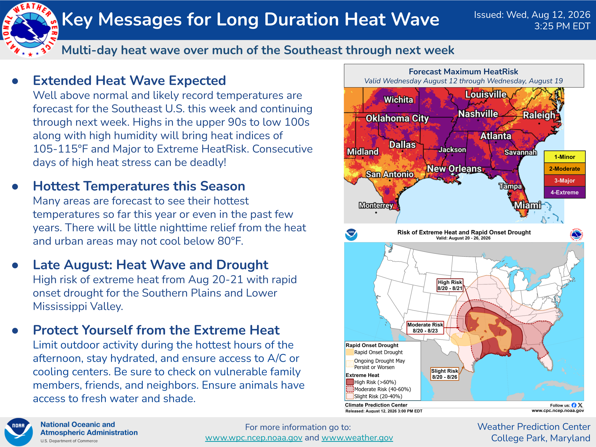
Not to be minimized is the heatwave that this upper level high pressure area will be bringing to much of the central and southeastern parts of the country for the next many days. As noted in the key points above from the Weather Prediction Center, some areas will see record high temperatures and/or the highest temperatures in the last few years. Combined with continued unseasonable humidity and abnormally warm low temperatures, serious heat stress is expected.
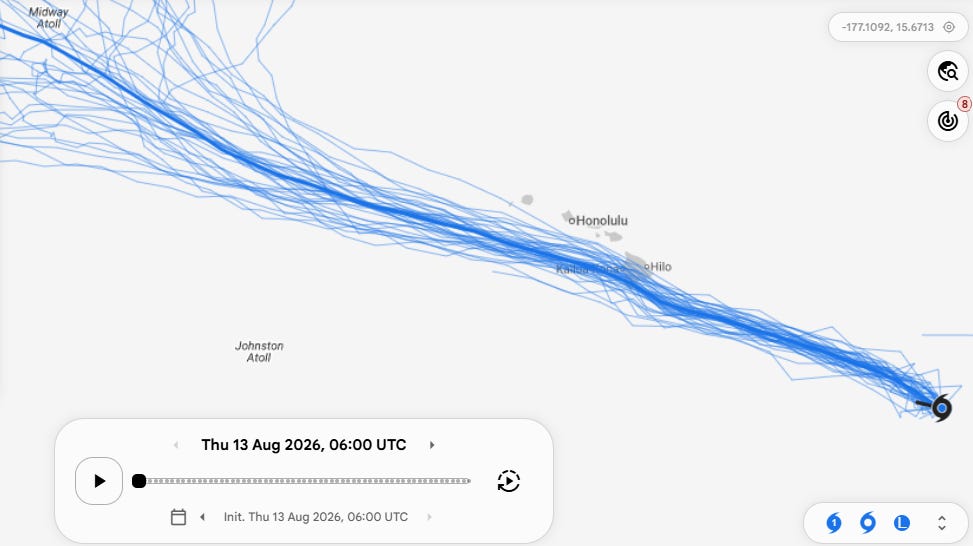
In the tropics, Tropical Storm Lala has formed in the central Pacific about 700 miles east-southeast of the big island of Hawai’i. It is expected to move west-northwest over the next few days and pass near or over said island this weekend.
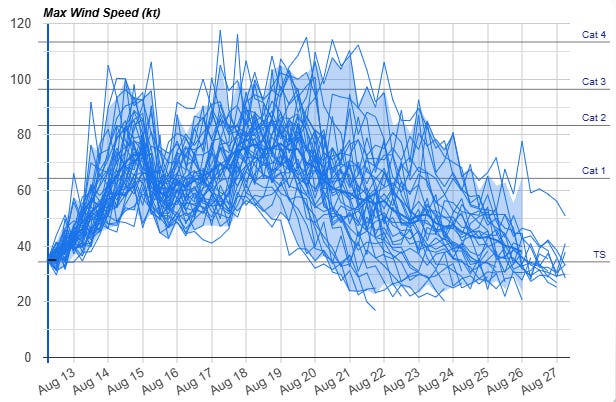
Conditions are generally favorable for intensification of Lala, and a consensus forecast from the Google DeepMind AI system suggests that Lala will be a strong tropical storm or category 1 hurricane as it passes the “Big Island.” A hurricane watch is in effect for the island. While Lala is expected to pass south of the other Hawaiian Islands and should weaken a bit, the islands will be on the stronger right side of the storm and should experience strong winds, heavy rain and high surf this weekend into early next week.
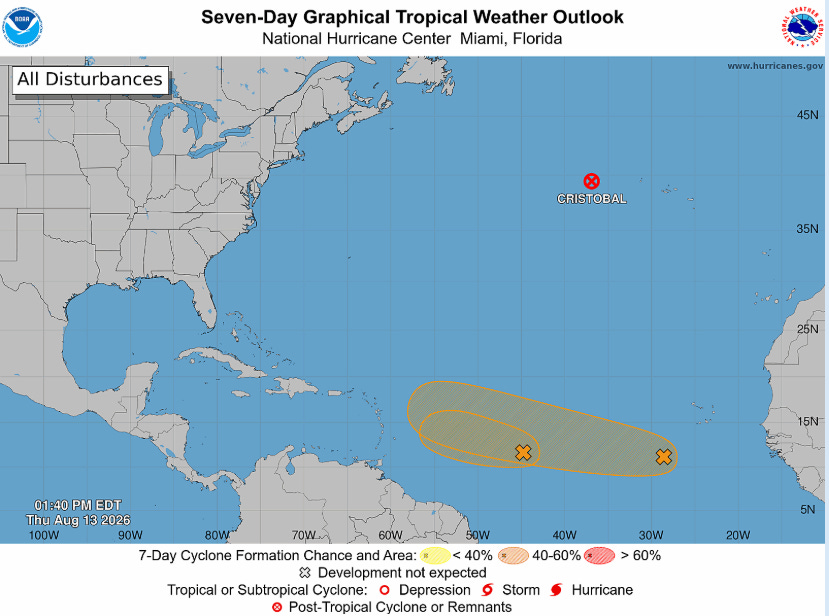
In the Atlantic, a low pressure system west of the Azores briefly obtained sufficiently organized thunderstorm activity to become Tropical Storm Cristobal yesterday, but has already degenerated into a remnant low. The westernmost system in the deep tropical Atlantic that we have following appears to have missed its window for development, and NHC has started to lower the probabilities for it. The models also seem to be less enthused about the easternmost system as well — not surprisingly given the increasingly strong El Nino in progress and overall hostile conditions in the Atlantic. We will keep an eye on them both though.
Programming note: Given the active weather expected into this weekend, I will likely be doing some Substack chats and possibly a live video or two. As a reminder, participating in these live events is a benefit that paid subscribers receive for their support of Balanced Weather.
Balanced Weather is made possible by the generous support of paid subscribers, who as thanks get access to live Balanced Weather chats and videos as well as the ability to post comments and ask questions on posts. To become a paid subscriber or a free subscriber (also very much appreciated and you will automatically receive new posts in your email), please click below.
No posts
Comments
Nothing yet. Say the first thing.
Sign in to join the conversation.