
As I expected, my post yesterday about the demise of the Central Pacific Hurricane Center brought me quite a bit of input from meteorological colleagues both within and outside of NOAA. NOAA colleagues seemed mostly aware of this change, and indicated that it was part of the broader reorganization that the agency has been pursuing in 2026.
This evolution was part of a series of changes to operational NWS entities that also included the absorption of the Climate Prediction Center by the Weather Prediction Center that I talked about in a late February post. From talking to various sources, it also included moving the Center Weather Service Units that provide crucial weather support to the FAA’s air traffic control system from under local Weather Forecast Offices — the organizational structure they were in during my entire NOAA career — to being a part of the national Aviation Weather Center. The NWS also combined the Environmental Modeling Center with the Meteorological Development Lab into a new NWS Office of Modeling and Development.
While NOAA colleagues I talked to mainly knew about these changes, most of the external colleagues I talked to were much less aware. These modifications may seem bureaucratic in nature, but I do think they have tangible implications on how the NWS produces forecasts and warnings and conducts its scientific work that are important for the broader meteorological enterprise to have awareness of — some potentially positive, some not so much.
For whatever reasons — political pressure, overwhelmed staff, or others — NOAA/NWS has not publicized these (and other) organizational changes in ways that I would expect based on my career experience. In fact and for what it’s worth, if you ask Gemini if the CWSUs are part of AWC, you get a response that no they are not, they remain independent entities under the broader NWS operational structure. If you ask if CPHC still exists as an independent entity, Gemini tells you not only that it is but also that it is actively monitoring and issuing forecasts for Lala. In my own searching, I was able to find one webpage that noted the new Office of Modeling and Development, but otherwise was not able to find any public information about recent NWS changes.
Perhaps all of this is just indicative of how federal science is going to be managed in our “new” environment. As someone who worked in a period of (mainly) open communication and collaboration among the public and external parts of the meteorological enterprise, I think it is counterproductive — and frankly depressing.
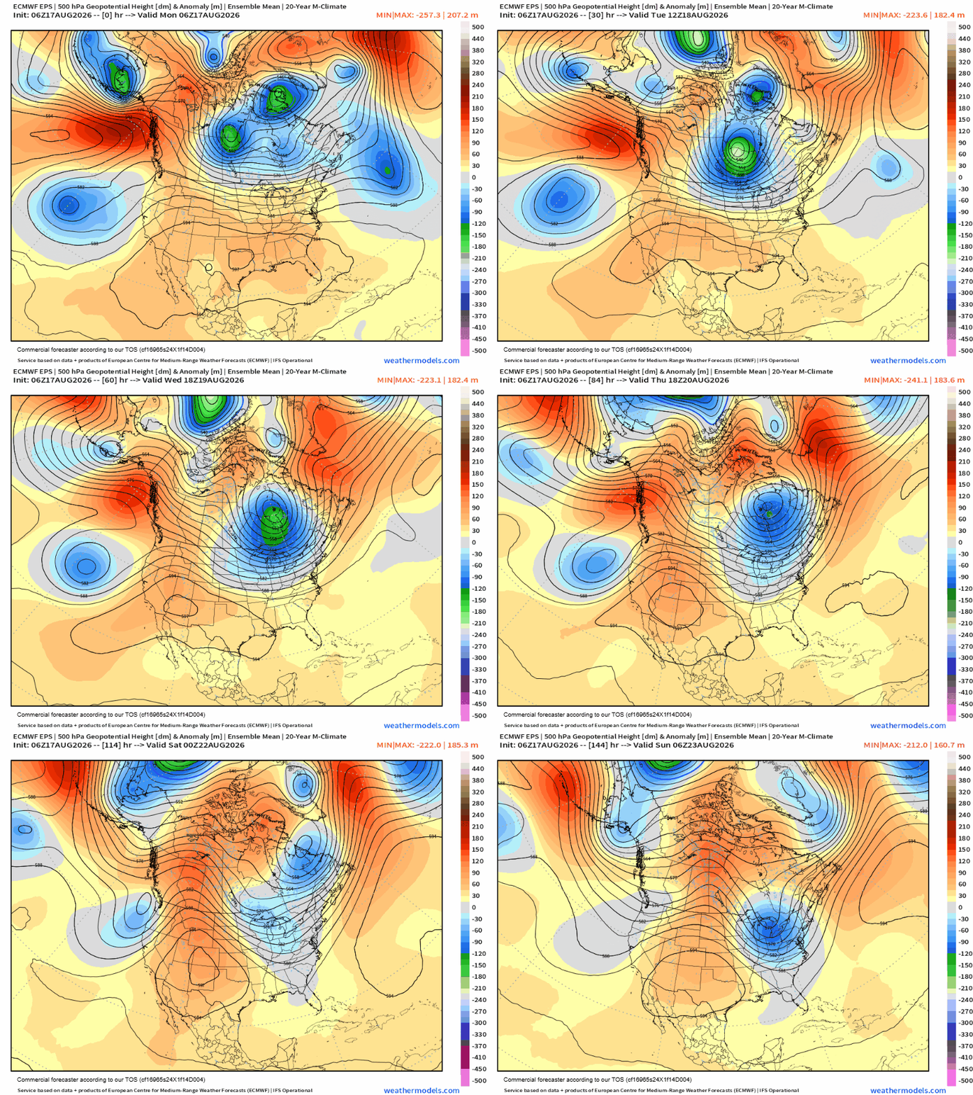
Looking at weather, we have a pattern change afoot this week back toward something we have seen frequently in the last couple of summers: an upper level trough of low pressure developing across the Northeast while an anomalously strong (at times near that magic 6000 m level at 500 mb) area of upper level high pressure across the Intermountain West and Southwest.
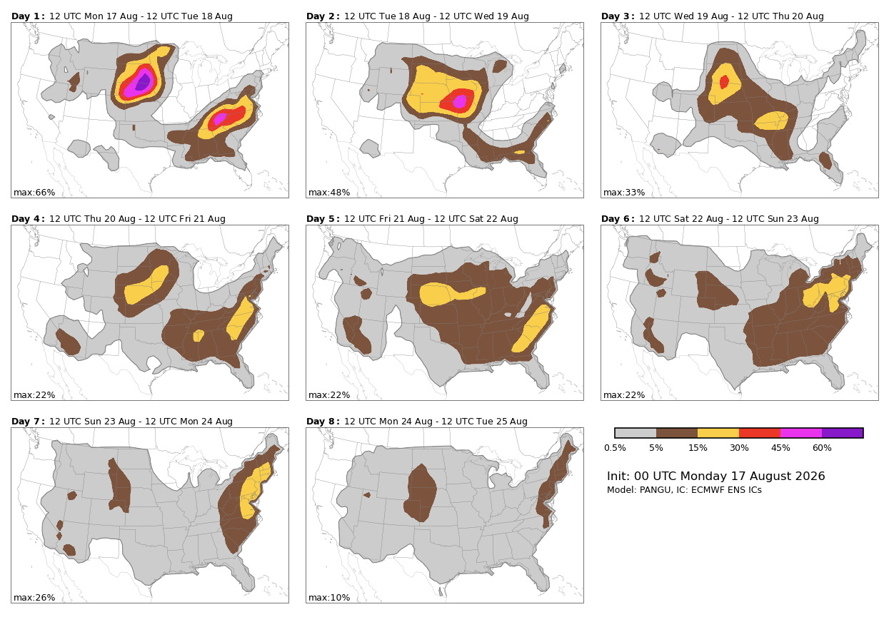
The evolution of the upper level pattern will result in some shifting in the pattern of thunderstorm activity across the Midwest and East that brought the record flooding and repeated severe weather to Indiana and surrounding areas the last 7 to 10 days. However, clusters of strong thunderstorms will continue to be an issue along the northeast edge of the building heat dome across the West, as well as to the east of the developing trough over the Northeast. Some severe weather risk (shown above) and flash flooding risk will continue to be a concern with these storms.
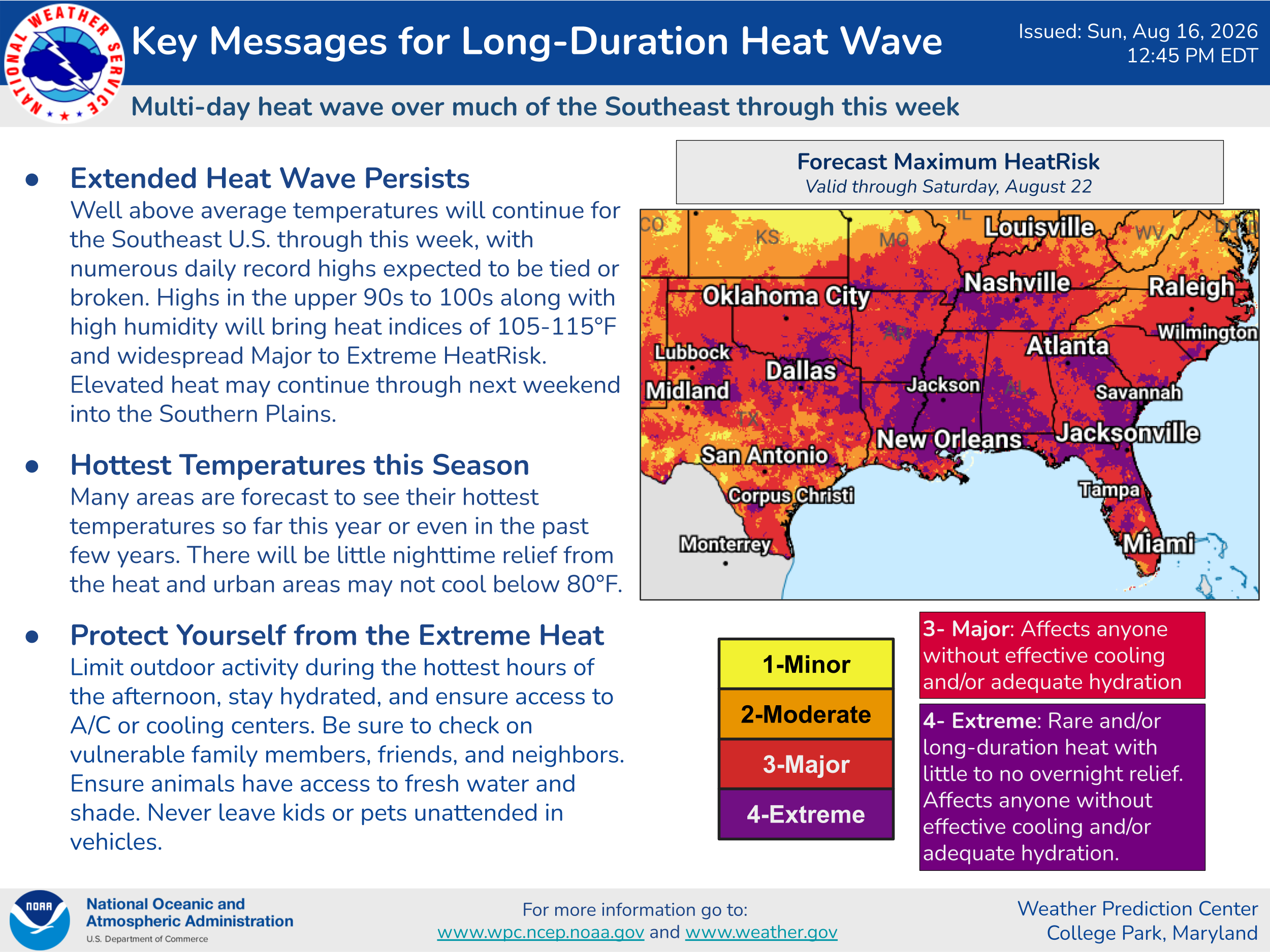
Significant and at times record heat will continue much of this week across the southern US. The combination of above normal temperatures and humidity will result in widespread major to extreme heat risk.
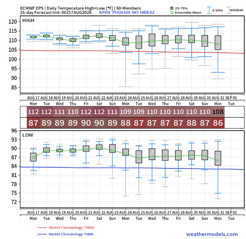
Unusual heat will also be returning to parts of the West as the upper level high pressure builds.
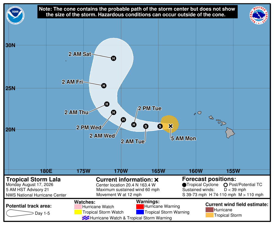
In the tropics, Lala will continue to pull away from the main Hawaiian Islands as it gradually intensifies and recurves over the central Pacific.
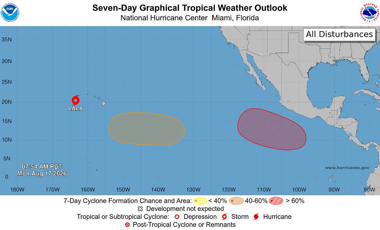
Two additional systems are possible in the central and eastern Pacific this week, but as of now they do not appear to pose any threat to land (at least in the next several days). After the demise of the couple of disturbances we were watching last week, the Atlantic appears as if it should have a quiet week again this week. My colleague Michael Lowry has a good summary this morning on the impacts of Lala to Hawai’i and the quiet Atlantic.
Balanced Weather is made possible by the generous support of paid subscribers, who as thanks get access to live Balanced Weather chats and videos as well as the ability to post comments and ask questions on posts. To become a paid subscriber or a free subscriber (also very much appreciated and you will automatically receive new posts in your email), please click below.
Comments
Nothing yet. Say the first thing.
Sign in to join the conversation.