
Welcome to a new week — and what looks to be a busy week of weather impacts. Before I get too deeply into that, I want to follow-up on my weekend post about the rapid growth of artificial intelligence (AI) and machine learning (ML) in meteorology. My colleague Daniel Swain highlighted in a LinkedIn post yesterday a new essay in the Bulletin of the American Meteorological Society raising doubts about the ability of AI approaches to replace physics based numerical weather prediction models. Daniel’s post and a quick skim of the essay made me want to give a quick addendum to my AI/ML post.
I am sure that I am oversimplifying this — but in my mind AI/ML in operational forecasting can be lumped into two general categories: AI “emulators” which actually replicate the longstanding physics based numerical weather models and produce predictions of the atmosphere itself, and AI/ML post-processing systems which take model predictions of the atmosphere and generate forecasts of hydrometeorological impacts. The latter category has been in development for many years, and was what I was primarily discussing in my post over the weekend.
Emulators — which include systems like Google’s GraphCast, Huawei’s Pangu-Weather, and NOAA’s HRRRcast and WoFScast — are a relatively newer effort, but are also showing serious promise. These systems appear to be able to produce reasonable forecasts of the atmosphere at a fraction of the computing resources, which opens to the door to possibility of rapidly updating ensemble forecast systems with thousands of members. However, as the BAMS essay I linked above notes, there remains plenty of scientific debate about the ability of these systems to truly be able to replicate the full spectrum of atmospheric outcomes given their training on past weather data.
Regardless of whether emulators can fully replace physics based models going forward, it seems clear that the combination of continually improving atmospheric models and rapid advances in AI/ML are going to yield a serious revolution in hydrometeorological predictions and how they are generated in the coming years.
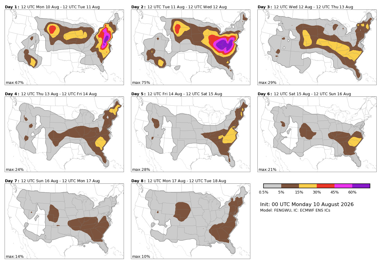
The AI/ML severe weather forecasting systems are portending an active period of severe thunderstorm activity this week. Disturbances in increasing northwesterly flow in middle and upper levels of the atmosphere on the north side of the strong upper level high pressure system over the southern US will bring complexes of southeast moving strong thunderstorms along a stationary front draped across the Midwest, Ohio Valley and Mid-Atlantic regions. Given the impressive levels of heat and humidity feeding these storm complexes, they will have the potential to produce swaths of significant straight line wind damage — and low level wind shear along the front could support a few tornadoes as well.
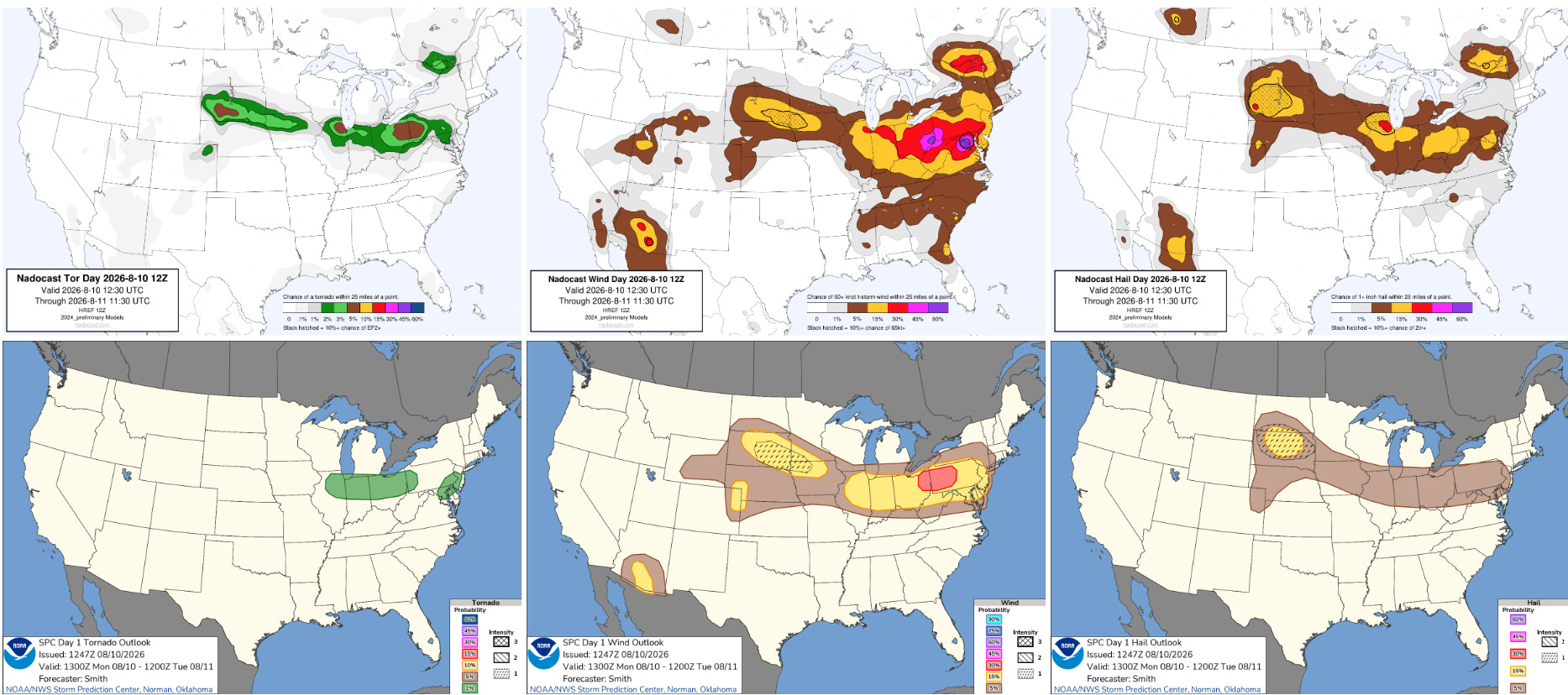
The heightened risk of severe storms will start today, with areas from the southern Great Lakes into the Mid-Atlantic at the greatest risk.
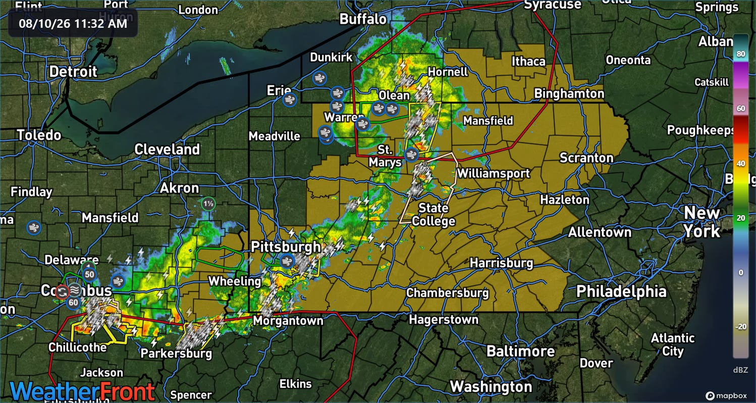
Severe weather has already been ongoing across parts of this region this morning, with a severe thunderstorm watches (orange shading) and warnings in effect and a number of reports of severe winds. More than 70,000 customers are without power in Ohio due to these storms per PowerOutage.us.
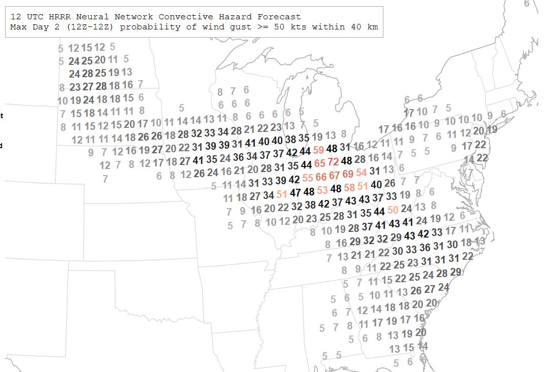
Tuesday looks even more concerning across this general region, as a particularly strong disturbance will drop southeast across the region with the potential for an intense complex of severe storms with widespread damaging winds. The NCAR day 2 probabilities above particularly highlight areas from southern Lake Michigan southeast into West Virginia.
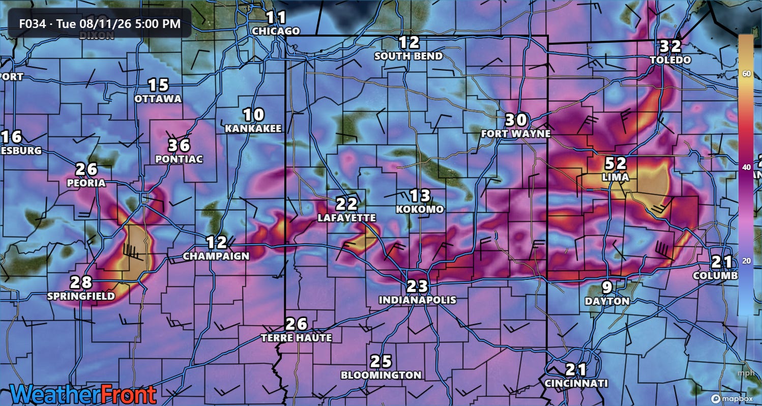
The exact timing, location and evolution of storm complexes for Tuesday are obviously hard to pin down — however, several of the high-resolution model forecasts are explicitly showing swaths of wind gusts of 80 to as high as 110 mph, indicating the potential for a high end severe wind event from storms across the region.
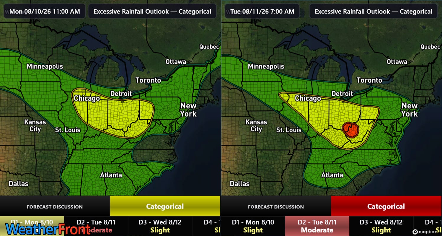
Flash flooding will also be a serious concern with this weather setup, as it will support the training of storms with torrential rainfall rates over some locations. The Weather Prediction Center has highlighted the same general region from the lower Great Lakes into the central Appalachians for the risk of flash flooding — including a moderate (level 3 of 4) for parts of West Virginia and southern Ohio on Tuesday and Tuesday night.
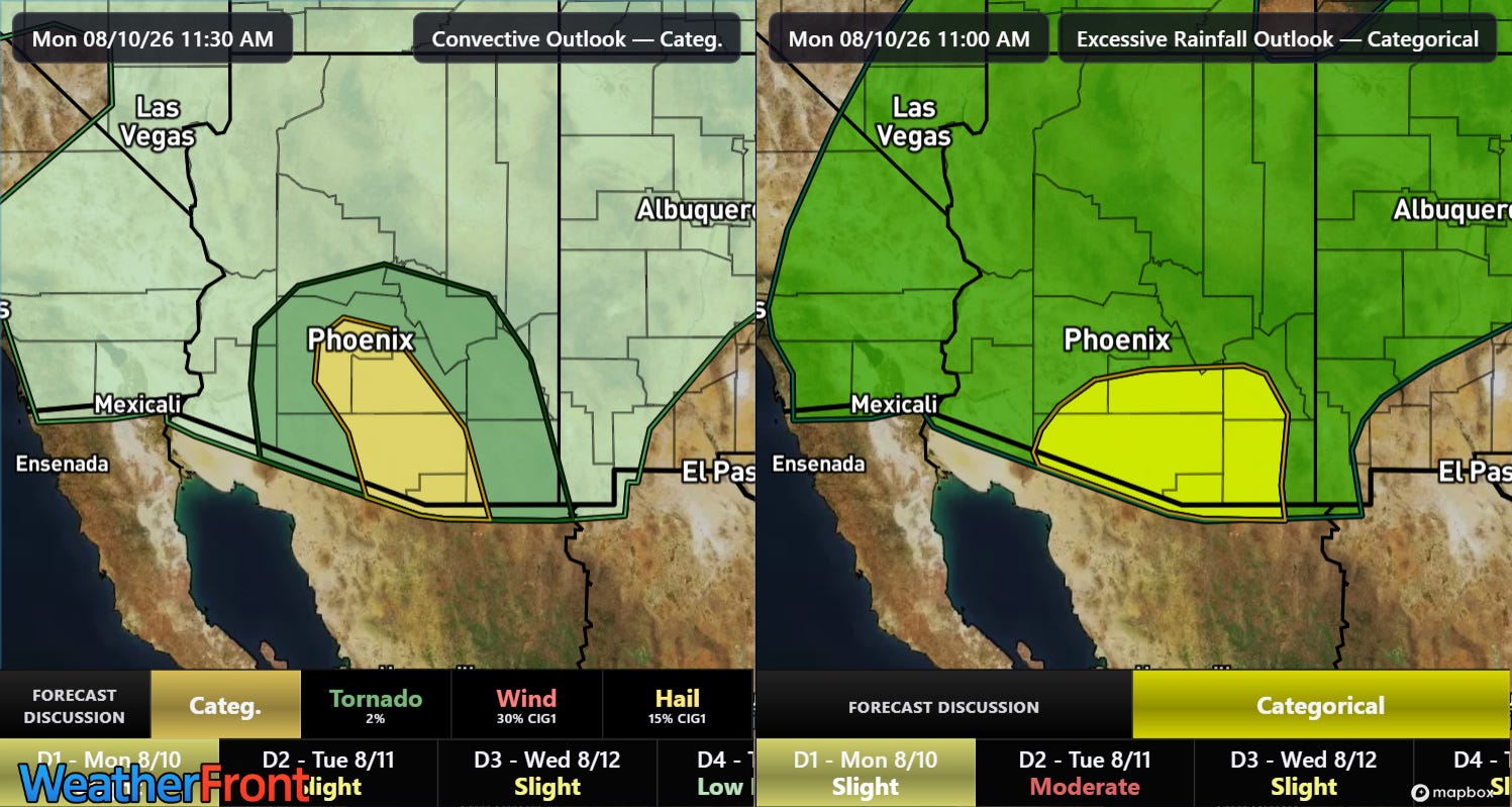
After a busy day of thunderstorm activity Sunday, southern Arizona will see more monsoon thunderstorm activity this afternoon and evening, with the potential for severe winds and flash flooding.
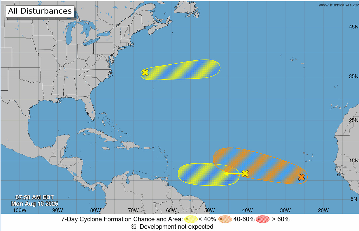
In the tropics, the Atlantic is finally showing some signs of life, with the National Hurricane Center monitoring three areas of interest. However, conditions in the basin are still not particularly conducive to development, and only the easternmost one currently south of the Cabo Verde islands shows much potential to develop into an actual tropical cyclone. Even if it develops (NHC currently shows the probability of it becoming a cyclone at 60%), it is unlikely to be a long-term, intense system with both the European ensemble and Google DeepMind forecasts showing it dissipating by early next week as it encounters strong upper level wind shear near and northeast of the eastern Caribbean.
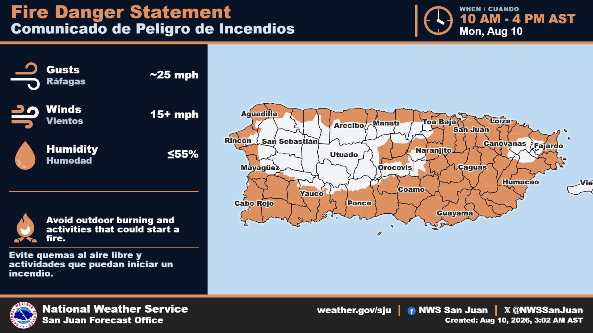
Of greater concern in the eastern Caribbean than tropical activity is continued extreme heat and fire danger in areas like Puerto Rico and the Virgin Islands. NBC News reported this morning on the growing humanitarian crisis in Puerto Rico due to water shortages and rationing due to ongoing severe drought.
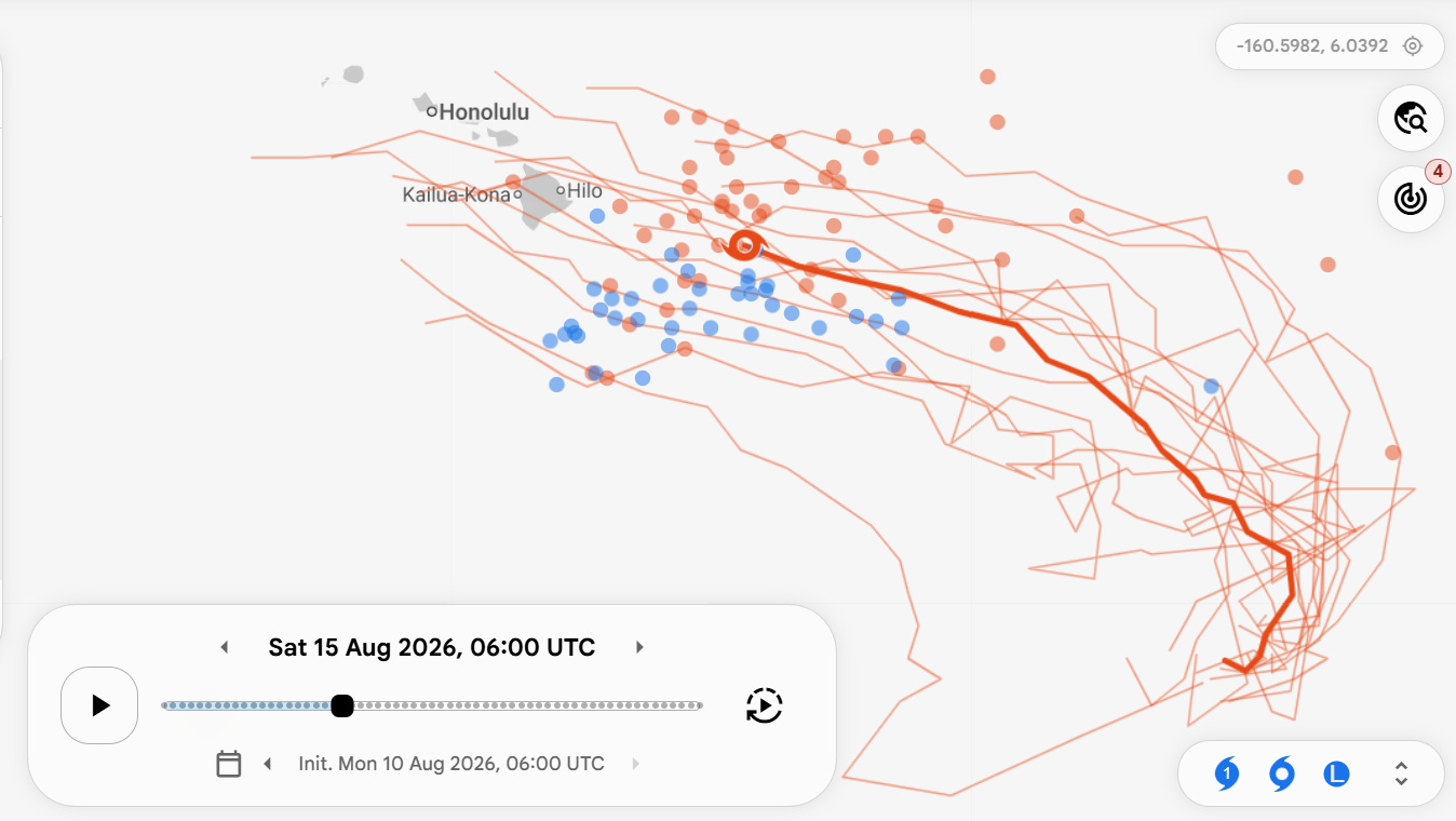
The western Pacific is currently quite active, with three ongoing tropical cyclones after Typhoon Dolphin made landfall in eastern China causing significant impacts and forcing hundreds of thousands to evacuate. The Central Pacific Hurricane Center in Honolulu is monitoring a disturbance (Invest 93C) about 1100 miles east-southeast of Hawaii which is shows a high (90%) chance of developing into a tropical cyclone this week. This system is expected to gradually intensify and move in the general direction of the Hawaiian Islands by this weekend — this is obviously a system we will be watching closely this week.
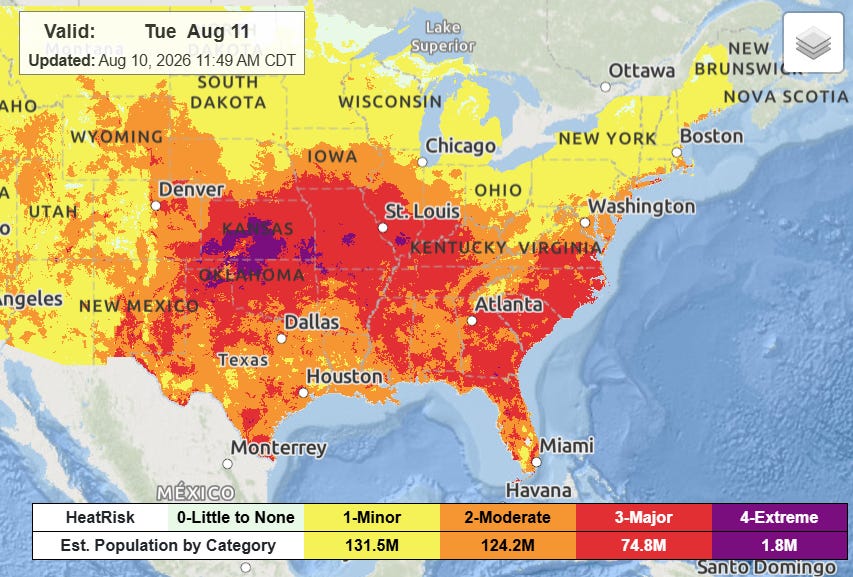
Last, but certainly not least, I need to highlight that major to extreme heat stress is going to be a serious problem under a building dome of upper level high pressure across the central and southeastern United States for the next several days. Visit https://www.wpc.ncep.noaa.gov/heatrisk/ for daily forecasts of heat risk across the country.
Programming note: Given the active weather expected this week, I will likely be doing some occasional live videos and Substack chats. As a reminder, participating in these live events is a benefit that paid subscribers receive for their support of Balanced Weather.
Balanced Weather is made possible by the generous support of paid subscribers, who as thanks get access to live Balanced Weather chats and videos as well as the ability to post comments and ask questions on posts. To become a paid subscriber or a free subscriber (also very much appreciated and you will automatically receive new posts in your email), please click below.
No posts
Comments
Nothing yet. Say the first thing.
Sign in to join the conversation.