
📚Copper Creek to Cumberland Gap: A Russell County Migration Research Guide is waiting in the Resource Library.
🔍 Free Members: Learn more about the benefits of Free vs. Paid. Click here.
🌲This newsletter runs on courthouse records and coffee. If this research saves you a trip to the archive, you can Buy Us a Coffee. 💚 ☕
🌲🌲🌲🌲
Appalachian Genealogy & History is a reader-supported publication. To receive new posts and support my work, consider becoming a free or paid subscriber.

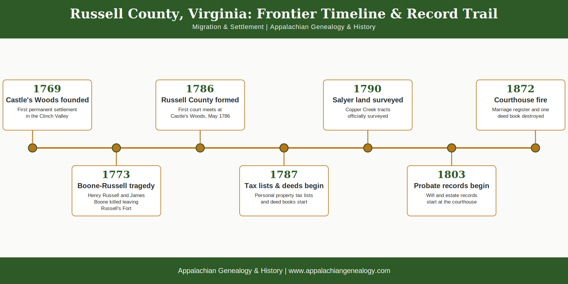
On the morning of October 8, 1773, Captain William Russell loaded a train of packhorses at his home in Castle’s Woods with farming tools, seed, and a few books, the family Bible among them. His seventeen-year-old son Henry rode out that day with James Boone, the Mendenhall brothers, a young man named Drake, and two of the Russell household’s enslaved men, Charles and Adam, bound for a meeting point three days south in Powell Valley (Drury and Clavin 2021). None of them made it that far. Two nights later a war party surprised the camp on Wallen’s Creek, and when Captain Russell reached the site the next afternoon, his son’s body lay among the dead with several painted hatchets left beside it, a declaration of war (Hamilton, n.d.).
Historical Context
The road existed because a Cherokee headman had agreed to move it. At the Congress of Lochaber in October 1770, more than a thousand Cherokee gathered at Alexander Cameron’s South Carolina plantation to negotiate with British Indian agent John Stuart over where the line between Cherokee land and colonial settlement would fall. When surveyors reached the spot where the new boundary was supposed to run, they found a cluster of Virginia families already squatting on the wrong side of it, north of the Holston River. Attakullakulla looked at the situation, said he pitied the settlers too much to make them move, and let the line shift west to take them in (Becoming America 250, n.d.; Encyclopedia Virginia 2025).
The boundary held, and settlers kept crossing into the valley behind it, Captain William Russell’s own household among them despite what he had buried on that road twelve years before. By 1785 the Clinch and Powell valleys held enough people that the ride to Washington County court for every land dispute and debt suit had become its own kind of hardship, and Russell, by then a delegate in the Virginia General Assembly, carried his neighbors’ petition into the House of Delegates himself. On January 2, 1786, the legislature cut a new county out of Washington County and put his name on it. The first court met that May in William Robinson’s house at Castle’s Woods, and the county it governed ran from Clinch Mountain clear to the Cumberland Gap (Wikipedia, “Russell County, Virginia,” 2026). When the marshal rode through counting heads in 1790, he tallied 3,338 people across all of it (VAGenWeb Russell County Project, n.d.).
The county’s own reach did not last. Lee County split off first, in 1792, and five more counties followed over the next seven decades, so a family’s deed might sit in a Russell County book while their grandchildren’s deeds sit in Wise, Buchanan, or Dickenson County without anyone in the family ever crossing a river (Wikipedia, “Lee County, Virginia,” 2026; FamilySearch Research Wiki, n.d.). The records themselves mostly survived that redrawing, carried into new courthouses with the neighborhoods they described. Fire did the damage the county splits never managed. When it reached the Russell County courthouse in 1872, eighty years after the first court convened, it took two things: the original marriage register and a single deed book. The other deeds, the order books, and the wills that came before them survived (Russell County Public Library, n.d.).

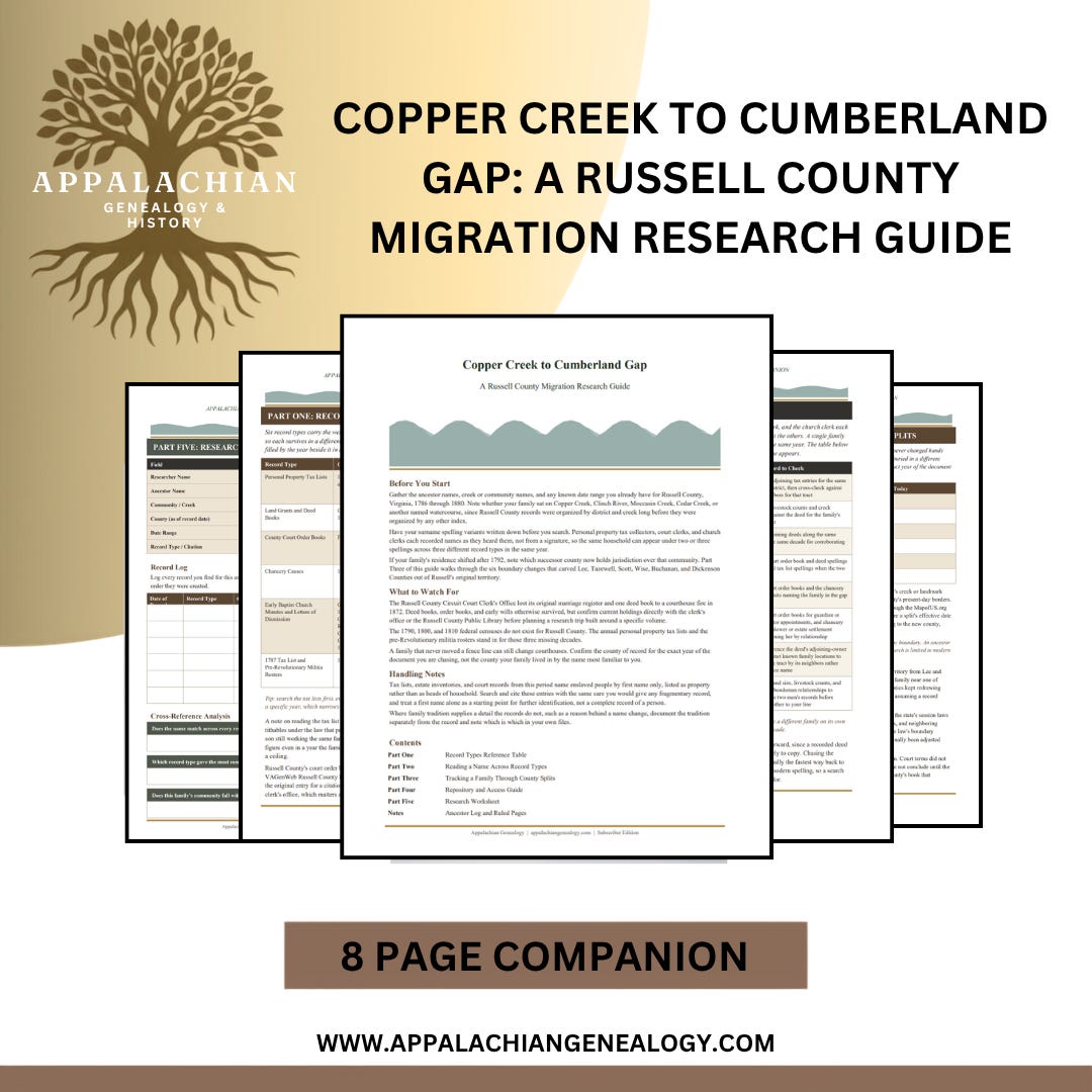
Copper Creek to Cumberland Gap: A Russell County Migration Research Guide
Somewhere on Copper Creek in 1787, a tax collector wrote “Stills, Isaiah, one horse, five cattle” and rode on to the next farm, never knowing he had just carried three years of a fugitive’s borrowed name into the permanent record. Russell County broke off from Washington County that same decade, but it did not sit still afterward. Six more counties split from its territory before 1880, so a family whose fence line never moved could still end up with a deed in one courthouse and a grandchild’s estate settlement in another. This guide moves through the record types that carry a Russell County migration story: the annual tax lists that stand in for three missing censuses, the deed and court order books that never stopped running through every split, the chancery causes where a family’s own sworn testimony survives, and the church letters of dismission that can name the exact place a household went next.
8 page PDF research guide includes:
Six-record-type reference table covering personal property tax lists, land grants and deed books, county court order books, chancery causes, early Baptist church letters of dismission, and the 1787 tax list and militia rosters that stand in for the missing 1790, 1800, and 1810 censuses
Signal interpretation table for catching aliases, spelling variants, and scribal substitutions across tax lists, deeds, and court order books
County-split tracking table for the six counties carved from Russell between 1792 and 1880, with the courthouse each now calls home and how to confirm jurisdiction by date
Repository and access guide scoped to Russell County and its six successor counties, including Virginia Untold for enslaved and free Black ancestors
Research worksheet with an ancestor identification block, a six-record-type entry log, and cross-reference analysis prompts
Notes pages
Appalachian Genealogy & History is a reader-supported publication. To receive new posts and support my work, consider becoming a free or paid subscriber.
Genealogical Connection
📜 Personal property tax lists ran every year from 1787 to 1850, and they will drop your family into a single year with everything they owned attached, horses, cattle, every enslaved and free person in the household, in exactly the decades no census survived to back them up.
🗺️ Land grants and deed books run continuously from 1787, and they will walk one tract of ground through every owner it ever had, corner call by corner call, straight back to the first survey stake driven into it.
⚖️ County court order books start in 1786, years before any comparable record does, and they catch admissions, road crews, and militia appointments while the ink was still wet on the county itself.
📖 Chancery causes at the Library of Virginia are where a paper trail goes when it runs cold everywhere else: testimony-heavy equity suits over land, estates, and debts, full of sworn statements nobody bothered to put in an ordinary deed.
⛪ Early Baptist congregations, Glade Hollows in 1788, Stony Creek in 1802, Russel in 1805, Castlewoods in 1806, Copper Creek in 1808, kept letters of dismission for every member who moved on, so church minutes can name where a family went when the county records just show them gone.
🪖 The 1790, 1800, and 1810 federal censuses are gone for this county, every one of them. The 1787 tax list and the pre-Revolutionary militia roster are what stand in their place.
If the Boone-Russell story from the start of this post has you wanting the fuller picture, Bob Drury and Tom Clavin's Blood and Treasure: Daniel Boone and the Fight for America's First Frontier opens with that same October morning and follows the Wilderness Road on into Kentucky. It's a New York Times bestseller, currently in print in hardcover, paperback, and audio, and it's the actual source behind this post's opening scene. Note: As an Amazon Associate, we earn a commission if this link is used to make a purchase.
From the Archives
Whoever rode the tax route on Copper Creek in 1787 wrote the names down as he reached each farm, not letter by letter, and that year three of them landed close together on the page: Osborn, then Stills, then Stapleton. The middle entry reads “Stills, Isaiah,” one horse, five cattle, nothing else, no more than the law required a man to declare (Russell County, Virginia, Personal Property Tax List 1787).
There was no Isaiah Stills farming on Copper Creek. Family tradition says a Tory reputation had followed Isaiah Salyer out of North Carolina close enough on his heels that for three years he answered to a name he’d borrowed rather than sign his real one where a magistrate might read it. The alias lasted exactly as long as the danger did. On March 26, 1790, with the new federal constitution ratified and whatever had been chasing him gone quiet, the Russell County surveyor wrote out sixty-six acres on the north side of Copper Creek, nearly opposite Joshua Penick’s dwelling house, close enough to Penick’s front door that a man could stand at one property line and see the other, cornering a tract that belonged to Isaiah’s own father, and now the name on the paper was close enough to real that his descendants could still find him two centuries later: Isaiah Salyard (Russell County Deed Book 1, 1790).
He never moved far after that. His brothers farmed the ground beside him, his sisters married into the families on the same creek, and when he died on Molls Creek in December 1818, four generations of Salyers were already root-bound into that stretch of Russell County deep enough that none of them left (Early Settlers in Russell County Historical Marker 1982; WikiTree 2023).
This post is free for everyone. If we just helped untangle something in your own research, buying us a coffee is the easiest way to say thanks and keep the lights on.
˗ˏˋ☕ˎˊ˗
Why It Matters
For a researcher chasing a Salyer, Saylor, or Sallyer ancestor out of Russell County, that one tax entry under an alias is the difference between a documented decade and a dead end. Search the 1787 tax list for “Salyer” and nothing comes up. Search for “Stills” and there he is, one horse and five cattle exactly where the deed books say he should be two years later. The same caution holds for any family that crossed into Russell County in those first uncertain years after 1770: check the deed books against the tax lists against the court order books, because a name that looks settled in one record can carry a different spelling, or a different surname entirely, in the next. The Russell County Public Library holds transcribed deed books covering 1787 through 1814, the exact years the 1872 fire spared, and running those transcriptions against the original tax rolls at the Library of Virginia is often the only way to catch an alias before it disappears into the next county over.
Copper Creek still runs through Grassy Creek the way it did in 1787, past a church and a roadside marker that remembers six names carved out of one family’s decision to stop walking.
💬 Did your family pass through Russell County on their way somewhere else, or did they stay put? Tell me which county they landed in next.
If this post gave you something to think about or a new trail to follow, consider restacking it. Every restack puts Appalachian Genealogy in front of someone who might be looking for exactly this. It takes one click and it means more than you know.
❤️ And if you found value here, a like helps too.
🌲🌲🌲🌲
📚 Resource Box:
Chancery Records Index (Library of Virginia) - searchable digital images of Russell County chancery causes for when a family’s paper trail runs cold elsewhere.
Virginia Chronicle: Digital Newspaper Archive (Library of Virginia) - a nearly complete run of the Lebanon News from 1935–2000, plus the Honaker Herald and Honaker Press, all full-text searchable.
Local History (Russell County Public Library) - transcribed deed books, tax lists, digitized yearbooks, and a photo archive held at the Lebanon and Honaker branches.
The First Massacre on Powell’s River (Russell County VAGenWeb, by Emory L. Hamilton) - Hamilton’s full firsthand account of the 1773 killing, including his correction of where the state marker actually got the location wrong.
Russell County, Virginia Genealogy (FamilySearch Research Wiki) - the single best hub for every major Russell County record collection, with direct links to each one.
🌲🌲🌲🌲
Sources
Claiborne Progress. 2022. "Settlers along the Wilderness Road: Part 2."
Drury, Bob, and Tom Clavin. 2021. Blood and Treasure: Daniel Boone and the Fight for America's First Frontier. New York: St. Martin's Press.
Early Settlers in Russell County Historical Marker. 1982. Virginia Department of Historic Resources marker series, Grassy Creek, Russell County, Virginia.
Encyclopedia Virginia. 2025. "The Treaty of Lochaber (October 18, 1770)."
FamilySearch Research Wiki. n.d. "Russell County, Virginia Genealogy."
Hamilton, Emory L. n.d. "The First Massacre on Powell's River." From the unpublished manuscript Indian Atrocities Along the Clinch, Powell and Holston Rivers.
Russell County, Virginia, Deed Book 1. 1790. Russell County Circuit Court Clerk's Office, Lebanon, Virginia.
Russell County, Virginia, Personal Property Tax List. 1787. Transcribed online at New River Notes.
Russell County Public Library. n.d. "Local History."
VAGenWeb Russell County Project. n.d. "Russell County Virginia Genealogy."
WikiTree. 2023. “Isaiah Benjamin Salyer Sr., 1752 to 1818.”
Wikipedia. 2026. "Russell County, Virginia."
Wikipedia. 2026. "Lee County, Virginia."
Thank you so much for supporting our publication.
The mountains remember because people like you refuse to let them forget.
🎙️ The Podcast - free for everyone
📺 The Videos - free for everyone
📚 The Resource Library - downloadable research companions included with every paid subscription
Appalachian Genealogy & History is a reader-supported publication. To receive new posts and support my work, consider becoming a free or paid subscriber.


Comments
Nothing yet. Say the first thing.
Sign in to join the conversation.