
1. Headline
The National Oceanic and Atmospheric Administration (NOAA) recently warned of a “super” El Nino developing in the eastern Pacific Ocean off the coast of South America, noting that it is likely to strengthen further through the end of the year — with the potential to become the strongest on record by a wide margin. El Nino and La Nina events are notorious for their impacts to weather around the world. Thus, the preceding headline raises eyebrows for those of us involved in agriculture. How do conditions like this get created? What is the forward risk? After a careful review of the main system drivers that impact planetary weather, we find just as complicated a picture as ever. That said, it is clear that regenerative practices offer producers more of a fighting chance relative to conventional operations. Additionally, thoughtful support efforts around the margins can add further resiliency to operations.
2. What does this mean?
Weather has always been a key risk for agricultural producers growing crops outdoors. However, this topic is becoming a bigger and more expensive concern nowadays. We’ve written previously about what amounts to strong evidence in the form of rising U.S. crop insurance payments that shows how increasingly chaotic weather events are destroying more farm production each year. To be sure, conventional agricultural practices lack sufficient resiliency in the rapidly warming world in which we now live. On top of longer droughts and harder rainfalls, forecasters are now calling for a “super El Nino” to be in place later this year into 2027. What does this mean for farmers in the U.S. and around the world? How can producers fortify their production systems to withstand climate change-induced weather extremes, ahead? In this report, we take a look at the world’s key climate systems along with what their broader interactions mean for the farming sector.
Once upon a time, we recall an environmental sciences professor telling us that “weather is how the atmosphere behaves at any given point in time. Climate, on the other hand, is a longer-term facilitator of these patterns.” Thus, in order to understand weather, one must first understand climate.
The Earth’s climate is extremely complex; however, its primary drivers include the following:
Incoming solar radiation from the sun
Earth’s revolution and rotation
Surface features of the land (latitude, altitude, proximity to water, etc.)
Composition of the atmosphere (e.g., rising CO2 levels)
The hydrologic (water) cycle is a major factor for the Earth’s climate, along with weather at any given point in time. Incoming solar radiation (heat) drives this cycle by evaporating water from oceans, lakes, rivers, and soil, with water also moving from plants to the atmosphere via the process of transpiration as the sun shines its rays on our planet. As liquid water evaporates or transpires, it forms water vapor and clouds, with water droplets eventually gaining enough mass to fall back to Earth as precipitation. Thus, the hydrologic cycle is, in effect, the sun’s energy moving from the ground to the atmosphere back to the ground. The sun’s energy also moves around our planet via the process of convection.
The Earth’s climate is influenced by three major convection cells: Hadley, Ferrel, and Polar. These three convection cells help to equalize the incoming solar radiation received on Earth by transporting excess thermal heat energy from the equatorial regions to the poles. This process ultimately helps produce wind around the planet.
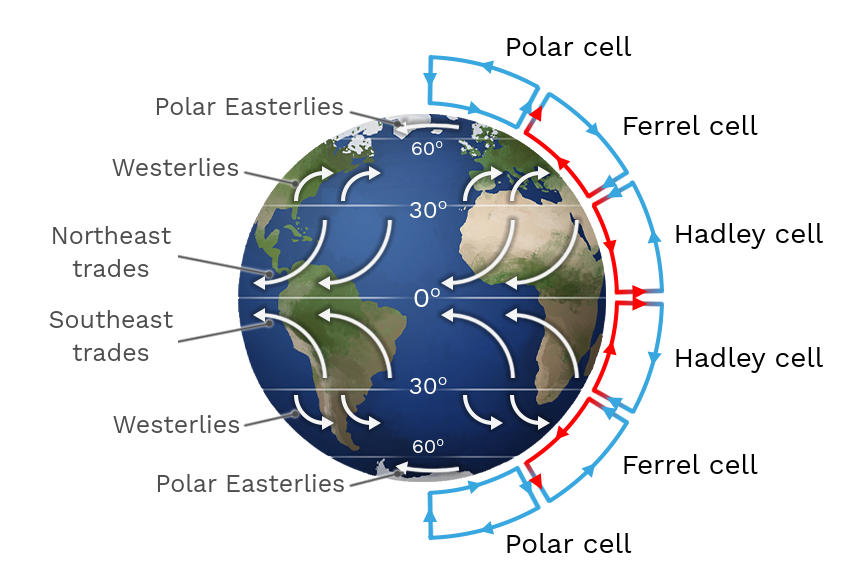
Incoming hot air at the equator rises up towards the Earth’s poles, whereupon cold air eventually comes back down towards the equator. Where air is rising, the pressure is low. Where air is descending, the pressure is high. Together, this interplay creates high- and low-pressure systems that influence specific weather dynamics (storms) in specific locations at given points in time.
Global wind patterns help carry this heat and these storms around the planet. The two major global wind patterns are the trade winds and the westerlies. Trade winds are below 30 degrees latitude around the center of the planet, while the westerlies are above 30 degrees latitude outside of the Tropics. Trade winds tend to blow west while the westerlies tend to blow east. While most heat moves around the planet from various wind patterns, ocean currents also have a say in the process, transporting the remaining 10%-20% of global heat distribution.
Although brief and rudimentary, the foregoing information provides an important base as we move to discuss the idea of climate oscillations. The latter is a grouping of long-term, large-scale patterns that exist within Earth’s climate system described above, contributing to events of extreme weather in the form of droughts, floods, and storms. It is, therefore, climate oscillations that strongly influence weather by shifting atmospheric pressure, altering wind patterns, and redirecting the flow of moisture and heat into different geographies for sustained periods of time.
The most well-known climate oscillation is that of the El Nino Southern Oscillation (ENSO), typically characterized in terms of an El Nino or La Nina event. However, there are eight other prominent climate oscillations that compete with ENSO to influence climate variability and weather around the world. Below, we take a brief look at all nine major climate oscillations and their current readings before moving into our takeaways for the farming sector writ large.
El Nino Southern Oscillation (ENSO)
The ENSO cycle is a pattern that involves 3-7 year changes in the temperature of Pacific Ocean waters off the coasts of Peru and Ecuador. Under normal conditions, trade winds from the east transport colder air to the warmer areas of the central Pacific Ocean. An El Nino event takes place when these trade winds weaken, leading to a warming of sea surface temperatures (SSTs). A La Nina event takes place when these trade winds strengthen, leading to below average SSTs. Thus, El Nino years are generally warmer for the planet overall while La Nina years are generally cooler for the planet. Current reading: strong El Nino developing.
Arctic Oscillation (AO)
The AO describes how pressure patterns are distributed over the Arctic region and middle latitudes of the Northern Hemisphere. It is a short-term change, usually taking place on the order of days to weeks, however it has a strong influence on the shape of the polar vortex, impacting pressure systems and the strength of the trade winds and the westerlies. A negative phase for the AO leads to weaker westerlies and trade winds, pushing colder air further south. This usually means colder and wetter winters in the U.S., Europe, and Asia. A positive phase for the AO leads to stronger westerlies and trade winds, meaning warmer winters in the U.S., Europe, and Asia. The AO can many times impact the North Atlantic Oscillation (NAO), another oscillation that we discuss next. Current reading: slightly negative; trending more negative.
North Atlantic Oscillation (NAO)
The NAO is an irregular fluctuation of atmospheric pressure over the North Atlantic Ocean that can have a strong effect on winter weather in the Northern Hemisphere. The oscillation can occur on a yearly basis or be as long as decades apart. When the NAO is positive, there is higher than normal pressure in the central-eastern Atlantic Ocean alongside lower than normal pressure to the north, over Iceland. This generally results in warmer, wetter conditions for northern Europe and eastern North America lasting into spring. A negative NAO leads to the reverse outcome, with colder conditions generally experienced in eastern North America and northern Europe. Current reading: very slightly positive; trending negative.
Antarctic Oscillation (AAO)
The AAO is also known as the Southern Annular Mode (SAM) and is a pattern of atmospheric variability concerning the north-south movement of the westerly wind belt that circles Antarctica. The AAO is the main climate driver for Australia and tends to shift on a bi-weekly basis. In its positive phase, weaker-than-normal westerly winds lead to higher pressures over southern Australia which, in turn, tend to foster greater rainfall in southeastern Australia during the spring/summer and drier-than-expected conditions across the whole of the country during the winter. In its negative phase, stronger westerly winds and lower pressure systems over southern Australia create conditions for dry months across the spring and summer in southeastern Australia along with stronger storms and rainfall across a wide swath of the country in the winter. Current reading: positive; trending towards neutral.
North Pacific Oscillation (NPO)
The NPO is a north-south fluctuation of winter atmospheric pressure and sea surface temperatures over the North Pacific Ocean, occurring on monthly timescales. Although more volatile relative to oscillations like ENSO, the NPO is very influential as it relates to winter air temperatures and precipitation across Canada, the United States, and parts of Mexico — more so than ENSO. When the NPO is in its positive phase, warming episodes take place across a majority of the North American continent, with more precipitation across the U.S. Midwest. A negative phase for the NPO can generally lead to cooler conditions across North America, with drier conditions in the U.S. Midwest. Current reading: positive.
North Pacific Gyre Oscillation (NPGO)
The NPGO is the oceanic expression of the NPO. It is also closely linked to the Pacific Decadal Oscillation (PDO), another oscillation that we discuss next. Variations of the NPGO can stay present for years at a time, making it a more reliable indicator relative to other oscillations. Given that the NPGO is an oceanic expression, its differing cycles tend to have more influence on marine ecosystems relative to air temperatures or storms. However, a positive NPGO can play a part in strengthening east Asian summer monsoons while leading to drier conditions in central regions like the middle and lower Yangtze River Basin. A negative NPGO can lead to the reverse conditions. Current reading: negative1.
Pacific Decadal Oscillation (PDO)
The PDO is a recurring pattern of varying ocean and atmosphere interactions within the mid-latitude Pacific Ocean basin, taking place over multiple decades (however, these phases have been shortening over time). During its positive/warm phase, above-average sea surface temperatures (SSTs) extend from the western coast of North America down to the equator, leading to warmer/wetter conditions in the eastern U.S. and cooler/drier conditions in the Midwest and west. During the PDO’s negative/cold phase, much of the U.S. is usually warmer than normal, with above-average rainfall in the Midwest. Current reading: negative.
Atlantic Multidecadal Oscillation (AMO)
The AMO is an alternation between long-period phases (60-80 years) of warm and cool ocean waters in the North Atlantic Ocean. During the positive/warm phase, above-average SSTs are seen over the North Atlantic Ocean and below-average SSTs are seen in the south. In the U.S., this can create conditions where droughts are more frequent and severe across the Midwest, while rainfall and storm activity around Florida can increase, all else equal. During the negative/cool phase, below-average SSTs are seen over the North Atlantic Ocean and above-average SSTs are seen in the south, creating conditions where rainfall is heavier across the Midwest and storm activity around Florida is more limited, all else equal. Current reading: slightly positive.
Indian Ocean Dipole (IOD)
The IOD is defined by the difference in SSTs between two areas — a western pole in the Arabian Sea and an eastern pole in the Indian Ocean south of Indonesia. Variations can take place across weeks or months, affecting the climate of Australia and other countries near the Indian Ocean basin. A positive IOD consists of low-pressure systems and warmer SSTs in the western Indian Ocean relative to the east. This can lead to intense rainfall in east Africa and India along with severe drought in southeast Asia and parts of Australia. A negative IOD consists of high-pressure systems and cooler SSTs in the western Indian Ocean relative to the east. This can lead to intense rainfall and flooding in southeast Asia and Australia along with drier conditions in east Africa and India. Current reading: negative; trending positive.
What does all of this mean for U.S. weather heading into the Northern Hemisphere’s winter, and beyond? The nine major climate oscillations agree on some anticipated weather impacts, ahead, while others are in direct conflict with each other. In instances where disagreement occurs, we are told to rely on stronger oscillations and/or their readings, however this is more art than science. And that realization is of course the main takeaway for any observer and, certainly, those of us involved in agricultural production. Nothing is a given. The global climate system is extremely complex and volatile. Uncertainty abounds — now, and in the future. But that doesn’t mean that we can’t use data and analysis to our advantage. And it doesn’t mean that we can’t try to plan, accordingly.
To start, current and trendline readings for the nine major climate oscillations suggest forward weather conditions as showcased in the U.S. map graphic below. To be clear, this is a best guess of conditions based upon comparative strength of current/forecasted oscillation reading strength along with their comparative strengths/capabilities relative to one another. Some climate oscillations may strengthen or weaken relative to others, ahead, leading to different outcomes compared to those presented below. Likewise, the current mix of readings could produce different outcomes relative to those expected simply due to nuances that human beings can’t measure or comprehend in real-time.
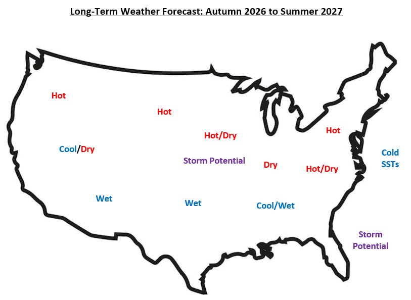
On its own, a “super” El Nino has the potential to severely exacerbate the expectations showcased above. Additionally, although an El Nino event typically means reduced risk for Atlantic storms around Florida, other readings like the AMO and a separate climate pattern called the Madden-Julian Oscillation (MJO) suggest that an El Nino event could effectively be “overridden” in this instance, supplying a counterweight that actually yields heightened storm activity off the Florida coast. This example helps color the sizable complexity of predicting future weather.
The complexity of the global climate system coupled with the potential for “super-sized” climate oscillations in the future are exactly why conventional farming practices no longer make sense for the American and global agriculture industry. Conventional agriculture is based on large-scale monocropping practices, widespread synthetic chemical application, and intensive tractor tillage, all of which destroy a soil’s microbiology and, therefore, its ability to defend itself from water and wind erosion. This, in turn, leads to pest and disease pressures for the crops planted into the ground, requiring greater levels of chemical applications that enflame an altered atmosphere and its global warming profile.
Regenerative agriculture practices like agroforestry are much more resilient in the face of climate change, working to rebuild microbiology in our soils, diversifying crop types on the farm, restoring biodiversity and protecting against pests and disease. Soil is better prepared for volatile wind and rainfall patterns, holding together and sequestering incremental carbon from the atmosphere to reduce global warming concentrations in the atmosphere. All of this said, the implementation of regenerative agriculture practices is no panacea for the increasingly chaotic weather impacts, ahead. Although risk is reduced in regenerative systems, ongoing threats remain in place — especially early on during farm transitions. This is why additional risk mitigation strategies are so important, to include novel insurance mechanisms, shared cost funding programs, early-transition practice overlaps, diversified supply chains, and scientific research.
3. Key takeaway
Since the mid-20th century, the world’s leaders have shown an inability to effectively partner on mitigating human-induced climate change. Thus, it is up to other parts of society to adapt to climate change as a new reality. In the agriculture sector, this means converting operations to regenerative practices like agroforestry in an effort to fortify soils and protect crop production. This is only part of the picture though. Climate oscillations like the El Nino Southern Oscillation (ENSO) will only get bigger and stronger in the decades to follow, requiring adjacent adaptive measures like insurance, cost sharing, multi-practice interventions, diversified supply chains, and ongoing plant genome research.
4. Where to find us
Check us out on our homepage or come connect with us on LinkedIn.
We’re an investment fund that raises money from long-term investors to pay farmers and landowners to plant trees on their properties alongside crops and/or animals, returning nutrients to the soil and our food while delivering attractive, uncorrelated returns to investors.
Thanks for reading Food For Thought from Agroforestry Partners! Subscribe for free to receive new posts pertaining to regenerative agriculture.
Last reading is from December 2025.
Comments
Nothing yet. Say the first thing.
Sign in to join the conversation.